Höckelsburg – Wikipedia
| Höckelsburg | ||
|---|---|---|
 |
||
| Alternative (n) | Heckelsburg, Hoekesborg (1486), Hoebelsburgk (1555), Hugelsburg (1587) | |
| Stands | Germany | |
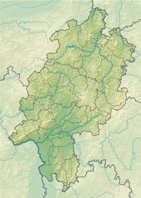
| Location | Herzhausen (Vöhl) | |
| Time of origin | between iron time and Latène time | |
| Burgstype | Höhenburg, Wallburg | |
| Conservation state | Wallreste | |
| Constant position | Rural Fliehburg | |
| Geographical location | 51 ° 12 ′ N , 8 ° 53 ′ O | |
| Altitude | 407 m ü. Nhn | |
|
||
The Höckelsburg is an output and probably created between the Iron Age or the Celts and is located about 1.5 km north northwest of Herzhausen, but in the district of Thalitter, both parts of Vöhl in the Waldeck-Frankenberg district (Germany).
The remains of the presumably former Fleihburg are located in the northern part of the Kellerwald-Edersee nature park in a forest area on the summit of the Höckelsburg (also Heckelsburg). The elongated and north-south direction has a height of 407 m ü. NN And lies between the valleys of the Itter in the east and the Wennenbach in the west. The federal road 252 from Frankenberg to Korbach runs along its eastern flank, in the valley of the Itter.
You can reach the system by parking about 1 km north of Herzhausen on the rest area on the B 252, taking the bridge over the Itter to the west and then turning shortly before reaching the Wennebach Valley (north). After reaching the height, forest paths lead south to the former castle. The less arduous ascent leads over the Höhenweg, which turns to the left (south) from Immighauser Straße west above Thalitter and leads through the field and forest far above the Ittertal to Höckelsburg.
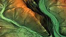
The mountain falls very steeply on both sides and on its south tip. This elongated triangular tip of the mountain is essentially level and north by a way that was caught up across the mountain ranges across the ride-up wall, but a path was broken during the forestry development. The wall was originally likely to have been a wall of about four meters and mostly consisted of graywackstones and bars. In the middle, there are relatively light, tuff -like porous, sometimes sintered stones that are sintered and interspersed with white quartz grains, so that one also speaks of a “slag wall”. Here, in order to destroy it, attackers apparently laid a large fire on the wall, which led to the slag and sintering of the gray wackers and the slump in the wall.
Neither the time of construction nor that of destruction are known with certainty, but it is assumed that the system was built about 500 years before the beginning of the Christian era, at the beginning of the Latène period and that it was built by the chat about a hundred years before our era was destroyed.
Since the Fleihburg was later in the border area between Chatten and Saxony, it may have served as a refuge again after its destruction and in the Saxon Wars of Charles.
The facility should not be confused with the Hünselburg, which is about 7.4 km further southeast below Basdorf, which is also regarded as a Celtic complex. Both are confused several times in the literature. [first]
- ↑ Hünselburg, Waldeck-Frankenberg district. Historical local lexicon for Hesse (as of December 14, 2012). In: State History Information System Hesse (Lagis). Hessian State Office for Historical Regional Studies (HLGL), accessed on December 14, 2012 .


Recent Comments