Square of Independence (Quito)
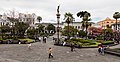
The Plaza de la Independencia , also known as big square , is the main square of the city of Quito (Ecuador), located in the old town. This is the Plaza Mayor of the capital, political and historical center of Ecuador, and symbolic seat of the president of Ecuador. It is the referential point of the city height, located at 2818 m s. n. m. Its main characteristic is the monument to Independence (Quito), dedicated to the heroes of the Independence of August 10, 1809, a date remembered as the first shout of Spanish -American Independence, which rises in the center.
The surroundings of the square is flanked to the west by the Palacio de Carondelet, south by the Metropolitan Cathedral of Quito, to the north by the Archbishop’s Palace of Quito and several buildings, and the East by the Municipal Palace of Quito.
The quadrilateral of the square is delimited by García Moreno, Chile, Venezuela and Espejo streets. The square has an approximate area of 8100 m², as its four sides measure approximately 90 m linear each.
Although the first place in the colonial city was the one that is now known as Benalcázar square, it was always considered provisional while a suitable route for the novel Spanish Villa de Quito was built. It was in the early seventeenth century, in 1612, when the powers of the city moved around the Plaza Grande, as they decided to call it for being the largest at that time.
Creature [ To edit ]

Initially, it was only an esplanade of appetized land in which in 1564 a water source was placed to supply the vital liquid to the neighbors, the work of Governor Hernando Salazar. [ first ] Being larger than the provisional square, and the land of the way to be still unemployed, some institutions decided to place themselves on their flanks. This is how the Catholic Church acquired land on the north and south sides, where it would build the main temple of the city (Primada Cathedral) and the headquarters of the Archdiocese (Archbishopal Palace).
The first town council of the city reserved for Francisco Pizarro a land in the northwestern corner of the square, next to the current Archbishop Palace, where his brother Gonzalo built a residence (the only private one that lasts until today), and which would later be called Pizarro Palace. [ 2 ] Other families, also of founders of the town, occupied the western end, but after the earthquake of 1627, they were overthrown by the severe damage that occurred in the structures, and instead the palace of the Royal Audience was built, currently currently known as Carondelet Palace.
Finally, on the eastern side the building of the Cabildo de la Nasiente City was built, construction that was also collapsed in the 1970s to build the building known as the Municipal Palace; While fulfill the same functions as the original, it is a modern edification.
XVI to the 19th centuries: the Spanish square [ To edit ]
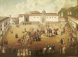
For several centuries after the foundation of Quito, the Plaza Grande was not about anything more than a large cobbled esplanade with a beautiful water source in the center, around which an impromptu bullring was sometimes built to celebrate some festivities offered by the Cabildo on behalf of the Spanish Crown. Unlike other colonial cities, there is no evidence that in the Plaza Grande there have been constructions of importance of indigenous people. The square also served as a market, and was known as Plaza de la Cathedral.
Just initiated the 18th century, the place was thought of as a true main square, in the style of European cities. The Spanish government conceives the landscape square, to serve as a garden for the Carondelet Palace. The Palace finished off its stairs in the square and the passage of carriages was prohibited through the western end of the same, which it collided with Carondelet.
The Baron of Carondelet orders the remodeling of the Royal Palace, around 1802, placing on the facade a large colonnade that becomes the framework of the square, as well as the construction of the atrium of the cathedral and the neoclassical temple with which the entrance to that church.
At the beginning of the 19th century, the square is reforming again, the stairs are removed from the palace, which now ended up in the side streets of the same, and the passage through the then called street of the 7 Cruces (current García Moreno) was enabled again.
Modern era: the French Park [ To edit ]


At the end of the 19th century and until the mid -twentieth, the Plaza Grande – who during the colony was a simple esplanade – was converted into a French -style garden, with a gate that surrounded her and several covers on the sides. This was an initiative of President Gabriel García Moreno, because before his government he continued to use the square as a market. From that time they date the oldest trees, especially the palm trees that are seen in front of the Archbishop Palace.
Around 1890 the water source built in the seventeenth century was replaced by a monument to Isabel la Católica, and the discarded structure was sent to the central square of Sangolquí, where it is located until today. [ 3 ]
In 1903, President Eloy Alfaro ordered the construction of a monument to commemorate the centenary of the first cry of independence in the country. The sculptural team would be located in the center of the square instead of the previous one of Isabel la Católica. The sculpture was commissioned to Francisco Durini, which was based on previous sketches of Juan Bautista Minghetti and his father Lorenzo Durini Vasalli. It was finished placing in the center of the square where the source was previously, which was moved towards the southwest.
In a public act held in 1906, the President of the Republic and the mayor of the city reveal the monument they baptized as a monument to independence and change the colonial name of the square for that of Plaza de la Independencia.
The model of converting the old Spanish inheritance square into a plotted park with a enclosure and covers, also a work by Francisco Durini in 1910, was emulated in other Ecuadorian major squares, such as that of Ibarra (Pedro Moncayo Park), Latacunga (Vicente Park León), Riobamba (Pedro Vicente Maldonado Park), Ambato (Juan Montalvo Park), Cuenca (Abdón Calderón) and Guayaquil (Seminary Park).
Around 1945, the gate and their gates were removed to give free access to the square, in addition the four metal batteries were replaced by the current carved stone. [ 4 ] Some of the gates were sold to individuals and are preserved in ancient mansions of the northern center of Quito.
The square is flanked on the four sides by different buildings, all, with the exception of the municipality, were originally built in the colonial era. All all, with the exception of the Pizarro Palace, they are public. These buildings are:
In addition, in the outer corners of the Plaza Grande team, there are four more buildings:
-

-

-

High view of the square from the East.
-
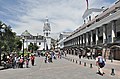
The Plaza Vista from the northwestern corner.
-
-

View from the entrance of the cathedral.
-
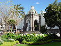
Carondelet arch, from the cathedral, towards the square.
-

-

-

References [ To edit ]
Bibliography [ To edit ]
external links [ To edit ]
Recent Comments