Ringwall Alteburg (Lorsbach) – Wikipedia
| Ringwall Alteburg | ||
|---|---|---|
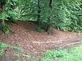
 The forewall in the southwest |
||
| Alternative (n) | Ringwall Schlingswald, Alteberg | |
| Stands | Germany | |
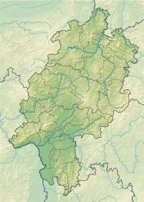
| Location | Hofheim am Taunus-Lorsbach | |
| Time of origin | Iron Age | |
| Burgstype | Höhenburg, Ringwallanlage | |
| Conservation state | Wallreste, reading foundation | |
| Geographical location | 50 ° 7 ′ N , 8 ° 24 ′ O | |
| Altitude | 297.4 m ü. NN | |
|
||
In which Ringwall Alteburg it is a ring wall system with an additional section attachment in today’s district Schlingswald , northwest of today’s Hofheim-Lorsbach in the Main-Taunus district in Hesse. The remains of the previously suspected early medieval, but in the recent finding, but iron -age rampart with high -altitude settlement are still well emerged as a ground monument in the landscape.

The Ringwall Altburg is around 500 m northwest of Lorsbach, on one 297.4 m ü. NN High, wide, east to the Schwarzbach valley, the mountain spur of the so -called Jewish head . The ridge is framed by steep sloping pages. Only in the southwest there is a flat transition to the mountain massif and the Langenhain plateau. The spur rises approx. 130 m above the Schwarzbach valley.
The system itself has a largely oval shape and measures 290 m in an east-west direction with a maximum expansion of 130 m in the north-south direction and, only seen the ring wall, takes an area of at least three hectares. [first] On the southwest side there was the highest risk of attack due to the flat transition. Accordingly, a section wall was upside down on the accessible mountain back. The actual ring wall system, largely expanded from an upcoming rock in the west to the southeast, was a double Graben Wall system. In the south, however, the outer wall is partially destroyed by modern road construction. On the eastern edge, which goes north from the way back to the north, the remains of a strongly flattened Annex wall, which run further to the east, should still be visible.
There is a shallow ditch in front of the outer wall. The wall itself reaches a height of about 1.5 m above the trench sole.
The more massive, inner wall is an approximately 1.0 m deeper. The wall rises over the sole of this trench by about 5.5 m. From the inside, this wall is only about 1.8 m high. On the south side, the wall flattened out of the inside view, whereby the exterior embankment is preserved to the northeast.
There are no remains on the north side, although it can be assumed that the system was also secured here.
A goal system cannot be found. It is conceivable that the gate was in the no longer perceptible north wall.
Further southwest there is an upstream section. This has a length of up to 165 m and runs in a slightly curved shape. The ditch reaches a width of 10 m at a depth of 1.5 m. The wall rises about 4.0 m over the sole of the trench.
The facility is developed via a historic circular hiking trail.
Larger amounts of find material were recovered in the 1970s. Some finds are assigned to urn field culture. The dating of most finds is essentially late Hallstattital or Frühlatène -Age (7th to 5th centuries BC).
The reading finds were mostly found on the inner southwestern wall area. A margin of a conical kink wall shell could be dated into the late Bronze Age (1300–800 BC). Of the 400 other wall shards, 356 of the older Iron Age (650–400 BC) could be assigned. The rest of the ceramic find of edge and ground shards can also be classified in the area of late Hallstatt period until spring time. All shards are assigned to handmade vessels. The ceramic finds show that the bowls, bowls and pots were provided with impressions and all -round bulges. 41 grinding stone fragments and 3 kg of hut clay with lichen work prints show a longer human settlement. [2] Iron finds (till lance tip with a medium rib, remnants of a tumbling aopia) are the level Hallstatt d1 counted. [3]
In the south (southeast of the western mountain tip), 5 podiums have been detected, which connects to the south of a terracification that is moving over half of the system. [4]
Two source areas are suspected as water access: a source at the western end of the inner wall of the ring wall system on a natural rock formation and another south of the mountain crest. [5]
There are no findings for a settlement in the early Middle Ages. Previous equations with a fastening Predia Leresbach According to a certificate of 995, there are no longer exposed to the fake of the 18th century. Only the double wall system allows a possible interpretation of the reuse of the system in the Middle Ages. [6]
Relief examinations show that the system was able to secure a wide environment and to connect to the approximately simultaneous system Altkönig, as well as the Kapellenberg. Settlement locations in the Hofheim core city, in Marxheim and Diedenbergen, as well as several burial mounds in the same area, could be counted as the catchment or influence area of the system. [7] In terms of location, the system is granted an important strategic defense and monitoring function of the transition zone between the fertile main level and Taunus. [6]
-

Local description of the wall system
-

View of Lorsbach from Tower on the ring wall
-
-

The wall system adjacent to the Alteburgerweg

The Tower on the ring wall is a lookout tower east of the wall system, located on the access from Altburgweg. In 2005 he was a successor to the Luisentempel built. The architect was E. Winkelmann, the new building was carried Heimat- und History Association Lorsbach e. V.
In 1907 the lookout tower was Luisentempel was built by the Taunusklub Lorsbach with the support of the Frankfurt publisher Ludwig Ravenstein. In honor of his late wife Luise, he received the name Luisentempel. The inauguration followed on May 31, 1908. The lookout tower developed into a popular destination.
During and after the Second World War, the tower fell so far that only the base plate was still present in 1950. There were also looting.
In the course of the Lorsbacher efforts to promote tourism, a new direction was carried out as a shelter in 1955 on the initiative of the Lorsbach Transport and Home Association, as the Taunus Club called itself.
In 1988, an initiative to rebuild the Luisent temple in the original form developed. However, this reconstruction could not be carried out due to legal problems.
From the money collected for the reconstruction, the Tower on the ring wall built. [8]
The area of the wall system is a ground monument according to the Hessian Monument Protection Act. Investigations and targeted collecting finds are subject to approval to report random finds to the monument authorities.
- H. Behlen: For wall castle research in Nassau . In: Nassau references , 1904/05 IV, pp. 118–129
- Thimo Jacob Brestel: The Altburg in the Schlingswald near Lorsbach. Leadership book for the fortified height settlement near Hofheim a. Ts.-Lorsbach, Main-Taunus-Kreis. (= Archaeological monuments in Hesse , Issue 31, 2nd completely new edition), ed.: State Office for Monument Conservation Hesse, Wiesbaden 2014, ISBN 978-3-89822-031-6. 23 pages
- Karl August von CoHausen: The Wallburg in the Schlingswald. In: Nassaui Annals 21 , 1889, S. 4 ff.
- Fritz-Rudolf Herrmann: The Altburg in the Schlingswald near Lorsbach. Leadership sheet to the early medieval ring wall near Hofheim a. Ts.-Lorsbach, Main-Taunus-Kreis. (= Archaeological monuments in Hesse , Issue 31 (old edition)), ed.: State Office for the Preservation of Monument Hesse, Wiesbaden 1983,
- Fritz-Rudolf Herrmann, Albrecht Jockenhövel: The history of Hesse . Konrad Theiss Verlag, Stuttgart 1990, ISBN 3-8062-0458-6. P. 409 (Fig.) And p. 410 (text)
- ↑ According to the management sheet to the system, 2.9 ha are given, measured due to the relief data, there are even 3.4 hectares of the wall system.
- ↑ Thimo Jacob Brestel: The Altburg in the Schlingswald near Lorsbach. Leadership book for the fortified height settlement near Hofheim a. Ts.-Lorsbach, Main-Taunus-Kreis. S. 16 f.
- ↑ Thimo Jacob Brestel: The Altburg in the Schlingswald near Lorsbach. Leadership book for the fortified height settlement near Hofheim a. Ts.-Lorsbach, Main-Taunus-Kreis. S. 18
- ↑ Thimo Jacob Brestel: The Altburg in the Schlingswald near Lorsbach. Leadership book for the fortified height settlement near Hofheim a. Ts.-Lorsbach, Main-Taunus-Kreis. S. 18 f.
- ↑ Thimo Jacob Brestel: The Altburg in the Schlingswald near Lorsbach. Leadership book for the fortified height settlement near Hofheim a. Ts.-Lorsbach, Main-Taunus-Kreis. S. 19
- ↑ a b Thimo Jacob Brestel: The Altburg in the Schlingswald near Lorsbach. Leadership book for the fortified height settlement near Hofheim a. Ts.-Lorsbach, Main-Taunus-Kreis. S. 20
- ↑ Thimo Jacob Brestel: The Altburg in the Schlingswald near Lorsbach. Leadership book for the fortified height settlement near Hofheim a. Ts.-Lorsbach, Main-Taunus-Kreis. S. 21
- ↑ The Luisent temple on the homepage of the Lorsbach Heimat- und History Association ( Memento of the Originals from March 4, 2016 in Internet Archive ) Info: The archive link has been used automatically and not yet checked. Please check original and archive link according to the instructions and then remove this note. (PDF; 30 kB)

Recent Comments