Alle Brancas — Wikipedia
L’ Brancas alley is a street in downtown Nantes, in France. It is an old quay of the port of Nantes on the Loire.
He is baptized in honor of Louis de Brancas (1672-1750), Marshal of France, Grand of Spain and knight of the Golden Fleece who is appointed Governor of Nantes and Commander of Brittany Le Brittany [ first ] .
The platform is divided after the revolution in two parts on both sides of the current Fleuriot-de-Langle square; Its eastern part is called “Quai Bouguer”, named after the hydrographer Pierre Bouguer (1698-1758) and, its western part, “Quai de Tourville”, in tribute to Charles Bertin Gaston Chapuis de Tourville (1740-1809), general [ 2 ] ; He then regained his original name before 1818 [ 3 ] .
The work to fill the “arm of the hospital”, which bordered it until the 1920s, modified the quality of the way, which of “quay” became, in 1945 [ 4 ] , an “aisle”, dedicated to car traffic.
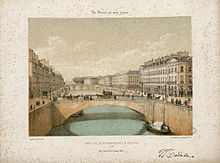
Before the filling work of the Loire, in the 1920 and 1930, this artery constituted a quay on the right bank of the “arm of the scholarship” which leaves room for the Franklin-Roosevelt course.
Since XV It is Century, the Loire bordered the ramparts between the Pont de la Poissonnerie (at the current rue de la Paix and rue Bon-Secours) and the Saint-Nicolas ditch (at rue La Pérouse). The idea of taking advantage of the construction of the Duguay-Trouin quay, to the north of FEYDEAU Island, to reduce the width of the Loire arm and improve navigability makes its way [ 5 ] .
In 1727, David Delafond, chief engineer of the king stationed in Nantes from 1721 to 1734, presented the plan of three successive quays, separated by the Erdre and the Saint Nicolas ditch. These platforms were allegedly built in front of the ramparts, reducing the width of the Loire arm. Delafond submits a second project connecting the Brancas and the Poterne platforms (current allée Flesselles) [ 6 ] .
Next comes the project of the architect Nicolas Portail, supplemented by the engineer Louis-Paul Abeille, who provides for an additional bridge over the Saint-Nicolas ditch, and the creation of a wheat hall and a hall Fish along the ramparts, on the Quai Brancas. Still according to this plan, an opening was practiced in the wall to create a “Porte de Mâtre” accessing rue Sainte-Catherine via a monumental portal [ 7 ] . In 1750, the plan was implemented but the prospect of the congestion caused by traffic around the two halls pushed the authorities to break the construction market; The works not having advanced very quickly, the only floor that has been mounted is destroyed [ 8 ] .
The architect Pierre Vigné de Vigny succeeds in convincing to have a performance hall and a concert hall built instead. Part of the land is sold to finance the project, accepted in 1757. The demolition of the arcades of the Halles ended in 1760 [ 8 ] .
Then comes the project of Jean-Baptiste Ceineray, new architect-rider from Paris, which sees greater. The destruction of the ramparts having been accepted, Ceineray offers an alignment of the quays and buildings which are there from Port-au-Vin to the castle. The Saint-Nicolas ditch is filled, the bridge at the mouth of the enlarged Erdre. It is this project that is ultimately emerging [ 9 ] . The building construction program was established in 1764, and, in 1767, the work was underway; They last a few years [ 8 ] . The general plan provides for the construction of a wheat hall, the floor of which would be occupied by a concert hall; This element, although approved, is not implemented [ ten ] .
Finally, a wheat hall located at the site of the Fleuriot-de-Langle square, was built in 1786, on the plans of architect Mathurin Crucy. This will be replaced by the “Hotel des Posts et Telegraphs” built between 1880 and 1884 by the architect Demoget [ 11 ] , replacing the building established on rue du Chapeau-Rouge [ twelfth ] .
At the western end of the quay, at the southeast corner of the Palais de la Bourse located on the Place du Commerce, leads to the “Bourse bridge” (replacing the “Feydeau bridge”, put into service in 1737), allowing the crossing of the “arm of the scholarship” to reach north of the Place de la Petite-Hollande, at the western end of Fydeau Island.
To the east, it was extended by the “Pont d’Erdre” which made it possible to cross the confluence between the river and its tributary, the Erdre, and to join the Quai Flesselles. Less wide than it was originally, this platform was enlarged and reinforced around the 1850s, to allow the railway line to Saint-Nazaire, extended from Nantes station in 1857 in 1857 .
In 1899, Maurice Schwob launched, in The Loire lighthouse , a campaign to promote a project by the director of the Paris Railway Company in Orleans, M. Heurteaux, which plans to raise the line that crosses the city by means of a rail viaduct between the Gare d’Orléans and the Quai d’Aiguillon, like the air sections of the Paris metro. The way once raised would have been located at the level of the first is floor of the quay buildings. This proposal, to which the mayor, Paul-Émile Sarradin, is favorable, is debated during the municipal council. But the project is not born, although it was once again proposed twice, without more success, in 1904, with modifications made by the chief engineer of the company of Orleans, M. Liébaux, then in 1926, after a readjustment carried out by the engineer of bridges and roads responsible for the work of the port, M. Marcheix [ 13 ] .
In 1918, the way, hitherto unique, was doubled (see the article on the Quai de la Fosse).
In 1941, rail traffic was turned south of Feydeau Island, on the land won by the filling of the “hospital arm”, then, after the Second World War, a tunnel was set up in the same place in the Old river bed [ 14 ] .
During the Second World War, a large part of the buildings of the Quai Brancas was destroyed during a bombing, but the Hotel des Posts remains intact [ twelfth ] , while a building located on the other side of rue du Couëdic is ripped [ 15 ] .
The Hotel des Postes Sere finally shaved in 1972, to make room for Fleuriot-de-Langle square [ 11 ] .
Since fall 2012, the aisle (like the work carried out on the course of 50-hostages) has become a “limited traffic zone”, where only cyclists, buses, intervention vehicles and those of residents, merchants, deliverers, etc. , are allowed to circulate [ 16 ] .
In the summer of 2019, the southern part of the Fleuriot-de-Langle square will have left room for a new building with an area of 1,132 m 2 on the ground, occupied by three levels of shops occupied by a single brand, as well as by a few dwellings [ 17 ] . The 1,200 m 2 commercial surfaces will be occupied by a ready -to -wear store in the Uniqlo brand [ 18 ] .
In the following table, the building at n O 1 of the Cassard alley and the building at n O 1 of the Brancas alley designate the same building, although two sheets are devoted to it in the merimed base; The registration under the historic monuments concerning the facades, each facade has been the subject of a sheet, which explains this fact.
- Foot 1906, p. 40. The year of birth is 1672, Édouard Pied announces 1711 by mistake, see ‘ Brancas family » (consulted the ) .
- Foot 1906, p. 40.
- Plan of the city of Nantes raised by Peccot, honorary architect of the city , 1818, municipal archives of Nantes, coast 1Fi46.
- ‘ Brancas (aisle) » , on catalog.archives.nantes.fr , Municipal Archives of Nantes (consulted the ) .
- Lelièvre 1988, p. 83.
- Lelièvre 1988, p. 85-86.
- Lelièvre 1988, p. 87-88.
- Lelièvre 1988, p. 89.
- Lelièvre 1988, p. 83-95.
- Alain delaval ( pref. Daniel Rabreau), Graslin theater in Nantes , Nantes, Joca would be, , 179 p. (ISBN 2-84809-021-9 ) , p. 16 .
- 2010 Pajot, p. 89.
- ‘ The past past » , on Point , (consulted the ) .
- Marcel Rumin, « The transformation of Nantes », The Annals of Nantes and the Nantes country , Nantes, academic society of Nantes and the Loire-Atlantique, n O 274 – “Nantes in 1900”, , p. 9-16 (ISSN 0991-7179 ) .
- Cornet 1996, p. 70-72.
- Thomas 1996, p. 131.
- Gwenaëll Lyvinec, ‘ Nantes: ZTL operation: limited traffic area » , on natesmertrome.fr , October 15, 2014 (dumb) .
- ‘ A new building on the Fleuriot Square in Langle », City of Nantes , ( read online , consulted the )
- ‘ Nantes. The Uniqlo brand will set up Square Fleuriot in 2019 », Ocean press , ( read online , consulted the )
Bibliography [ modifier | Modifier and code ]
- Chantal Cornet, The filling of western Venice , Montreuil-Bellay, CMD editions, coll. “Memory of a city – Nantes”, , 92 p. (ISBN 2-909826-37-6 ) .
- Pierre Lelièvre, Nantes at XVIII It is century: town planning and architecture , Paris, Picard editions, coll. « Architectures », , 295 p. (ISBN 2-7084-0351-6 ) .
- Édouard Pied, Notices on the streets of Nantes , A. Dugas, , 331 p. , p. 39-40 .
- Patrick Thomas, Nantes. 3, the 1940-1944 bombings , Montreuil-Bellay, C.M.D. editions, coll. “Memory of a city”, , 148 p. (ISBN 2-909826-41-4 ) .
- Stéphane Pajot, Nantes Street History , Les Sables d’Olonne, d’Orbestier, , 215 p. (ISBN 978-2-84238-126-4 ) .
Related articles [ modifier | Modifier and code ]
external links [ modifier | Modifier and code ]
Recent Comments