CERNON (Jura) – Wikipedia
For homonymous articles, see Cernon.
Cernon is a French commune located in the Jura department, in the Bourgogne-Franche-Comté region.

Cernon is located in the Jura department. In 1822, the town of Menouille or Menouilles, which had just over 200 inhabitants at the time, was attached to Cernon.
Neighboring municipalities [ modifier | Modifier and code ]
Geology and relief [ modifier | Modifier and code ]
THE CABORNE DE CERNON-MENOUILLE, 6 200 m long, is among the 100 longest underground systems in France [ first ] .
Climate [ modifier | Modifier and code ]
The Météo-France weather station installed in the town of Cernon at a place called the Cité EDF and commissioning in 1968 makes it possible to continuously know the evolution of the weather indicators [ 2 ] .
| Month | jan. | feb. | mars | april | May | June | jui. | august | sep. | oct. | nov. | dec. | year |
|---|---|---|---|---|---|---|---|---|---|---|---|---|---|
| Average minimum temperature (° C) | −1.5 | −1,7 | 0.9 | 3.7 | 7.8 | 11.3 | 13.1 | 12.9 | 9.5 | 6.5 | 2.1 | −0.7 | 5.3 |
| Average temperature (° C) | 2.1 | 2.9 | 6.4 | 9.6 | 13.5 | 17.2 | 19.2 | 19.1 | 15.2 | 11.4 | 6.1 | 2.7 | 10.4 |
| Average maximum temperature (° C) | 5.7 | 7.4 | 11.8 | 15.5 | 19.2 | 23.1 | 25.4 | 25.3 | 20.9 | 16.3 | ten | 6.1 | 15.6 |
| Cold record (° C) record date |
−24 10.01.1985 |
−18,8 05.02.2012 |
−17.5 01.03.2005 |
−6,7 08.04.2003 |
−4.5 03.05.1979 |
0.5 05.06.1975 |
3.5 22.07.1980 |
1.5 31.08.1986 |
−2 September 30, 1995 |
−5.5 31.10.1997 |
−12 November 25, 1971 |
−18.6 20.12.2009 |
−24 1985 |
| Heat record (° C) record date |
17 30.01.2002 |
22.2 24.02.2021 |
25.2 17.03.2004 |
28 April 29, 2005 |
33.1 25.05.2009 |
37.2 22.06.2003 |
38.5 July 31, 1983 |
38.6 13.08.2003 |
32.3 14.09.2020 |
28.4 07.10.2009 |
23.5 08.11.2015 |
20.5 December 16, 1989 |
38.6 2003 |
| Precipitation (mm) | 136,1 | 119.4 | 120 | 122.2 | 138.1 | 112.8 | 112.4 | 115.3 | 115.9 | 148.9 | 161.7 | 165 | 1 567.8 |
Typology [ modifier | Modifier and code ]
Cernon is a rural commune, because it is one of the municipalities that are not very little dense, in the sense of the municipal gate of density of INSEE [ Note 1 ] , [ 3 ] , [ 4 ] , [ 5 ] .
In addition, the town is part of the Oyonnax attraction area, of which it is a town of the Crown [ Note 2 ] . This area, which brings together 40 municipalities, is categorized in the areas of 50,000 to less than 200,000 inhabitants [ 6 ] , [ 7 ] .
The town, bordered by an inner body of an area greater than 1 000 hectares, Lake Vouglans, is also a coastal commune within the meaning of the law of , called coastal law [ 8 ] . Specific town planning provisions are applied there to preserve natural spaces, sites, landscapes and ecological balance of the coast, such as the principle of unconsciousness, apart from urbanized spaces, on the band coast of 100 meters, or more if the local town planning plan provides [ 9 ] , [ ten ] .
Land use [ modifier | Modifier and code ]

The occupation of the soils of the town, as it emerges from the European database of Biophysics of Corine Land Cover (CLC), is marked by the importance of forests and semi-natural environments (67,3 % in 2018), a proportion significantly equivalent to that of 1990 (68.3%). The detailed distribution in 2018 is as follows:
Forests (62.5%), meadows (26.5%), shrub and/or herbaceous (4.8%), heterogeneous agricultural areas (2.8%), urbanized areas (1.9%), continental waters [ Note 3 ] (1.3%), arable lands (0.2%) [ 11 ] .
The IGN also provides an online tool to compare the evolution over time of the soil occupation of the municipality (or territories to different scales). Several eras are accessible in the form of aerial cards or photos: the Cassini card ( XVIII It is century), the staff map (1820-1866) and the current period (1950 to today) [ twelfth ] .
1822: attachment of a menouille to Cernon;
1973: attachment of Viremont to Cernon.
2022: On August 11, the town of Cernon was completely evacuated, because of a virulent forest fire which threatens the town. Largages of helicopters and Canadair allow you to just save the village [ 13 ] .

The evolution of the number of inhabitants is known through the population censuses made in the municipality since 1793. From 2006, the legal populations of the municipalities are published annually by INSEE. The census is now based on an annual information collection, successively concerning all the municipal territories during a period of five years. For municipalities with less than 10,000 inhabitants, a census survey relating to the entire population is carried out every five years, the legal populations of the intermediate years being estimated by interpolation or extrapolation [ 15 ] . For the municipality, the first exhaustive census falling within the framework of the new system was carried out in 2004 [ 16 ] .
In 2020, the town had 234 inhabitants [ Note 4 ] , in decrease of 7.51%compared to 2014 (Jura: −0.72%, France excluding Mayotte: +13%).
Places and monuments [ modifier | Modifier and code ]
- Holy-Romain-et-Barula church;
- Chapel Saint-Onet de Ménouille;
- Tournerie de Ménouille (20th century), registered with the IGPC since 1992 [ 19 ] ;
- Saut-Mortier dam whose power plant has been registered with IGPC since 1991 [ 20 ] ;
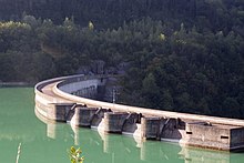
- Vouglans dam, which the municipality shares with Lect, and the whole generator of energy has been registered with the IGPC since 1991 [ 21 ] ;
- Barrier power plant, registered with IGPC since 1991 [ 22 ] ;
- Workers’ city (20th century), at a place called “La Cité”, registered at the IGPC since 1991 [ 23 ] ;
- Jumped workers’ houses (20th century), rue des Lézines, registered at IGPC since 1991 [ 24 ] ;
- Maison du Finage (20th century), near the dam, registered at IGPC since 1991 [ 25 ] ;
- Belvedere of Châtelet (20th century), dominating Lake Vouglans.
Personalities linked to the municipality [ modifier | Modifier and code ]
external links [ modifier | Modifier and code ]
Bibliography [ modifier | Modifier and code ]
Notes [ modifier | Modifier and code ]
- According to the zoning of rural and urban municipalities published in November 2020, in application of the new definition of validated rurality in the interministerial rurality committee.
- The concept of cities attraction areas replaced the old concept of urban area in October 2020 to allow comparisons consistent with other countries of the European Union.
- Continental waters designate all surface waters, generally, alternative waters from rainwater, which are located inside the land.
- Legal municipal population in force at 1 is January 2023, vintage 2020, defined within the territorial limits in force at 1 is January 2022, Statistical reference date: 1 is January 2020.
References [ modifier | Modifier and code ]
- Chabert Claude, ‘ Large French karst phenomena by figures » , on perSee.fr , (consulted the ) , p. 4.
- ‘ Post sheet 39013004 » [PDF] , on DONNEESPULIQUES.METEOFRance.fr , (consulted the )
- ‘ Urban / rural typology » , on www.observatoire-des -territoires.gouv.fr (consulted the ) .
- ‘ Rural commune – Definition » , on INSEE website (consulted the ) .
- ‘ Understand the density grid » , on www.observatoire-des -territoires.gouv.fr (consulted the ) .
- ‘ Base of attraction areas for 2020 cities. » , on INSEE.FR , (consulted the ) .
- Marie-Pierre de Bellefon, Pascal Eusebio, Jocelyn Forest, Olivier Pégaz-Blanc and Raymond Warnod (INSEE), ‘ In France, nine out of ten people live in the attraction of a city » , on INSEE.FR , (consulted the ) .
- ‘ The municipalities subject to the coastal law. » , on www.observatoire-des -territoires.gouv.fr , (consulted the ) .
- ‘ The coastal law » , on www.collectivites-locales.gouv.fr (consulted the ) .
- ‘ Law relating to the development, protection and enhancement of the coast. » , on www.cohesion-territoires.gouv.fr (consulted the ) .
- ‘ Corine Land Cover (CLC) – Distribution of areas in 15 land use stations (metropolitan area). » , on the Statistical data and studies site of the Ministry of Ecological Transition. (consulted the )
- IGN, ‘ Evolution of the town’s land use on ancient maps and photos. » , on Remonterletemps.ign.fr (consulted the ) . To compare the evolution between two dates, click on the bottom of the vertical dividing line and move it to the right or left. To compare two other cards, choose the cards in the windows at the top left of the screen.
- ‘ Miscellaneous facts. Canada, Evacuation … The point on fires in the Jura in Vescles-Cernon near Lake Vouglans » , on www.bienpublic.com (consulted the )
- Jura prefecture, List of mayors elected in 2008 , accessed May 2, 2010
- The organization of the census , on INSEE.fr.
- Departmental censuses calendar , on INSEE.fr.
- From the villages of Cassini to today’s municipalities On the site of the School of Advanced Studies in Social Sciences.
- INSEE – Legal populations of the town for years 2006 , 2007 , 2008 , 2009 , 2010 , 2011 , 2012 , two thousand and thirteen , 2014 , 2015 , 2016 , 2017 , 2018 , 2019 And 2020 .
- ‘ Menouille turnerie (20th century) » , notice n O IA39000505, Mérimée Base, French Ministry of Culture .
- ‘ Jump-off power plant (20th century) » , notice n O IA39000495, Mérimée Base, French Ministry of Culture .
- ‘ Energy generator set of the dam (20th century) » , notice n O IA39000491, Mérimée Base, French Ministry of Culture .
- ‘ Dam center (20th century) » , notice n O IA39000490, Mérimée Base, French Ministry of Culture .
- ‘ Workers’ city (20th century) » , notice n O IA39000494, Mérimée Base, French Ministry of Culture .
- ‘ Workers’ houses (20th s) » , notice n O IA39000493, Base Mérimée, French Ministry of Culture .
- ‘ Maison du Finage (20th century) » , notice n O IA39000492, Base Mérimée, French Ministry of Culture .
Recent Comments