Cèze — Wikipedia
For the article with a homophone title, see sixteen.
| The cèze | |
 Sautadet waterfalls in La Roque-sur-Cèze. |
|
 Cèze course. |
|
| Features | |
|---|---|
| Length | 128.3 km [ first ] |
| Bowl | 1 360 km 2 [ 2 ] |
| Collector | the Rhône |
| Medium flow | 22 m 3 /s (at the confluence with the Rhône) |
| Manager | Abcèze or mixed union of development of the cèze watershed [ 2 ] |
| Diet | Pluvial Cévenol |
| Course | |
| Source | source |
| · Localisation | Saint-André-Capcèze |
| · Altitude | 798 m |
| · Contact details | 44 ° 25 ′ 36 ″ n, 3 ° 58 ′ 09 ″ e |
| Confluence | the Rhône |
| · Localisation | Between Codolet and Laudun-l’ardoise |
| · Altitude | 27 m |
| · Contact details | 44 ° 06 ′ 18 ″ n, 4 ° 42 ′ 40 ″ e |
| Geography | |
| Main tributaries | |
| · Left Bank | La Ganière, La Clayssse |
| · Right bank | L’Homol, le Luech |
| Country crossed | |
| Departments | Lozère, Gard, Ardèche |
| Regions crossed | Occitanie, Auvergne-Rhône-Alpes |
|
|
|
| Sources : Sandre: ‘ V54-0400 » , Googleportail, Banque Hydro, Openstreetmap | |
| modifier |
|
The Cèze is a French river, tributary of the Rhône on the right bank, which flows mainly in the departments of Lozère and Gard, in the Occitanie region. It also runs along the Department of Ardèche, in the Auvergne-Rhône-Alpes region, also binds over a kilometer.
His name, in Occitan Cessation or This ser comes from a preceltic hydronym (probably a compound * zig-ar- > * success ). Medieval spellings ( Cicper in 817) testify to a Romance pronunciation close to that of Latin cĭcĕr , ‘Chickpea’ [ 3 ] (Occitan This ser ).

The first digging of the valley dates back to Burdigalien (second subdivision of the Miocene, from –20.44 to –15.97 million years): tectonic and eustatic events in the Rhodano-Provençal basin in Miocene have generated several phases of digging and filling, with the main digging in the superior Burdigalian. Following which the Cèze valley underwent two sediment clearing phases: one during the Tortonian (“infra-tartonian”) and the other during the Messinian; Each of these two clearing phases being preceded by a filling phase. It differs in this from the Rhône valley, whose digging took place during the Messinian salinity crisis (5.96 to 5.33 million years) at the end of the Miocene [ 4 ] .

The length of its stream is 128.3 km [ first ] .
The cèze has its source in the department of Lozère, in the territory of the town of Saint-André-Capceze at an altitude of 798 meters, on the western slope of the neighboring summit called “Truc du Samblonnet” listed 973 m. It then flows into the Gard department, except a portion of approximately 1500 meters from its left bank located in the town of Malbosc, in the department of Ardèche. The river flows into the Rhône between Codolet and Laudun-l’Ardoise in the Gard department at the altitude of 27 meters.
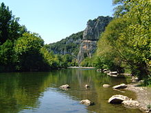
Downstream of Barjac, it forms the lower valley of the Cèze or Val de Cèze. From Rochegude to the gates of Bagnols-sur-Cèze, the river has dug gorges which form a set certainly less spectacular than those of the Ardèche located about ten kilometers to the north, but worthy of interest and easier to ‘access. There are the Sautadet waterfalls, with its impressive formations cut in the rock. The villages of Montclus and La Roque-sur-Cèze, among the most beautiful villages in France, are located on the Gorges.
Located north of the Gard department, and for a small part on the departments of Lozère and Ardèche, the Cèze watershed occupies a total area of 1,359 km 2 Of 99 municipalities including 85 in the Gard.
The cèze is cut by the Sénéchas dam – located in the municipalities of Chambon and Malbosc, upstream of Peyremale -, in its high valley, to the confluents of the homol and the Luech. This dam is a regulator (dancer), especially at the times of the floods (Cévenols episodes), which protects the cities of Bessèges and Saint-Ambroix located downstream.

His bed is parallel to the Ardèche bed.
Municipalities crossed [ modifier | Modifier and code ]
In three departments, the cèze crosses forty-one municipalities [ first ] . The most important are:
Watershed [ modifier | Modifier and code ]
The cèze crosses the nine hydrographic zones V540, V541, V542, V543, V544, V545, V546, V547, V548 of 70 186 km 2 total area [ first ] . This watershed is made up of 43.56% of “Agricultural territories” , at 28.37% of “Forests and semi-natural environments” , at 5.54% of “Artificialized territories” , at 0.90% of “Water surfaces” , at 0.15% of ” wet area ” [ first ] . The area of the cèze watershed is 1,360 km 2 [ 2 ] or 1 359 km 2 [ 5 ]
Manager [ modifier | Modifier and code ]
The managing organization is the abcèze or mixed union of development of the cèze watershed [ 2 ] .
The main tributaries of Cèze are, starting upstream:
Left Bank :
- Chandoullière
- Bournaves
- Niverette
- Lalle (vallat of)
- La Ganière (RG), 27.3 km in seven municipalities with eighteen tributaries
- Montagnac (Vallat de)
- Plauzolle (Vallat de)
- Saint-Brès (Vallat de)
- Malcap (Vallat de)
- Large vallat
- la Claysse, 21,9 km Of five municipalities with nineteen tributaries.
- Millies
- Roumejac
- Destel (were you walled)
- Issarts (Vallat des)
- Rodières (stream of)
- Valbonne (Vallat de)
- Derbèze or Passadouire

right bank :
- Chambonnet
- Connes
- L’Homol
- Lei lube
- Forge (Vallat de la)
- Row set
- Fontfrède (Vallat de)
- Graveirolles (stream of) and its tributary the barnassac
- VEBRON (Vallat de) or Moulinet (Vallat du)
- Auzon (and its 19 tributaries including Auzonnet and Alauzen)
- Aiguillon (and its tributary the adegue)
- Vionne
- Purple (vallat of)
- Riaufrès or Pijadon (Vallat)
- Roubine
- Tave (and its tributaries La Mayre, the Veyre, the La Brives stream, the Auzigues stream)
The river experiences violent floods in the spring and fall and very low water periods in summer. In case of strong drought, it can even disappear completely over several hundred meters at the level of Tharals, as happened in September 2011 [ 6 ] and in August 2017 [ 7 ] .
La Cèze in La Roque-sur-Cèze [ modifier | Modifier and code ]
The interannual average flow of the cèze was observed and calculated over a period of 53 years in La Roque-sur-Cèze (1961-2013).
He goes up to 18 m 3 /s For a 1,060 pool surface km 2 , that is the largest part (78%) of its watershed (1,359 km 2 ).
The river presents seasonal flow fluctuations typical of the Cévenol regime, with high fall and winter waters with double summit. The first summit takes place in October with an average monthly flow of 28.1 m 3 /s , then after a drop to 23.4 m 3 /s In December, a new summit occurs, ranging from 30 m 3 /s In January at 26.3 in February. This period is followed by an intermediate and prolonged period of sustained flow throughout spring, ranging from 20.4 in March to 17 in May. From then on, we are witnessing a rapid fall in the flow, ending in a low-cost period in July-August with a drop in the average monthly flow at the level of 3.5 m 3 /s These two months. From September the flow goes back [ 8 ] .
Stalling or low waters [ modifier | Modifier and code ]
In low water, the VCN3 can drop up to 1,2 m 3 /s , in the event of a dry ten -year period.
Flood [ modifier | Modifier and code ]
Floods can be extremely important and are completely extraordinary in France and undoubtedly in Europe. This is also the case for its neighbors the Ardèche and the Gardon. They generally occur following Cévenols thunderstorms. Indeed, the Qix 2 and the Qix 5 are 670 and 1,100 respectively m 3 /s , which is huge for such a small watershed. The Qix 10, even more impressive, is 1,400 m 3 /s , while the Qix 20 and Qix 50 display the gigantic figures of 1,700 and 2,100 m 3 /s [ 8 ] .
The maximum instantaneous flow recorded in La Roque-sur-Cèze was 2,010 m 3 /s the first is October 1977 (debit much higher than the average rate of the Rhône), while the maximum daily speed was 1,200 m 3 /s October 24 of the same year.
Water blade and specific flow [ modifier | Modifier and code ]

The water blade in the river watershed is 537 millimeters annually, which is very high, but quite clearly lower than those of the Gardon and the Ardèche its neighbors, this being due to the very reduced area of Its high basin in the Cévennes chain, where precipitation is very abundant. The specific flow or QSP thus amounts to 17 liters per second and per square kilometer of the basin.
The cèze is a gold river like many rivers in the region. Gold panning was practiced there until the beginning of XIX It is century.
The Cèze valley is subject to several environmental protection zones [ 9 ] , of which the following:
- Although not included in the central zone from ” Cévennes biosphere reserve »Who stops at the western limit of his watershed [ twelfth ] , it is indirectly affected by the zone tampon of this biosphere reserve [ 13 ] Through its tributaries already mentioned as part of the Cévennes National Park, which cause source in this zone tampon . In addition, all its route up to 10 km downstream from Saint-Ambroix is covered by the transitional area of the Biosphere Reserve [ 14 ] (Increase the protection due to the Cévennes National Park).
- The Upper Vallée de la Cèze has since been fully included in the 13,080 ha of the Special Conservation Zone (ZSP) Natura 2000 called ” High valleys of the cèze and luech Under the Habitats Directive, within the Cévennes biosphere reserve . The types of cutlery included in this area are made up of 40% of coniferous forests, 20% non -resinous sempervirent forests, 20% of moors, brushwood , recrus , Maquis, Garrigues and Phrygana, 10% of caudifoliated forests, 5% of interior rocks and rocky scree, 2% of wet or improved mesophilic semi-natural prairies and 2% dry lawns. Part of these habitats, including mowing meadows and chestnut groves, are dependent on the maintenance of traditional human activities; These gradually ceasing, these environments are subject to the closing of the environment for mowing meadows, and the development of diseases and the destructuring for chestnut groves.
- Five resident sedentary species are registered in Annex II of the Habitats Directive: the common beaver ( Castor fiber ), the otter ( Luther Luther ), le blageon ( Teleses Souffia ), the crayfish with white legs ( Austropotamobius in the ball ) and the southern beard ( Barbus southern ). The common beaver ( Castor fiber ) and the otter ( Luther Luther ) have uninlamed populations there but on the sidelines of their distribution area; For the otter, this site is the only present in Mediterranean sides and therefore of capital importance for the colonization of Mediterranean rivers.
- The Natura 2000 site ” High valleys of the cèze and luech »Explains 80% in the Gard and for 20% in Lozère, with only around 370 ha in the town of Malbosc in Ardèche [ note 1 ] , [ 15 ] , [ 16 ] .
- La ZNIEFF « Average cèze lessons », Or 647.91 ha, concerns 16 municipalities [ note 2 ] And is fully understood in the Cévennes National Park. The targeted habitat is made of fallow land and vacant lots. The Natura 2000 file mentions two protected plant species throughout the metropolitan French territory: the officinal gratiole ( Gratiola officinalis , a scrophular) and the summer spiranthe ( Spiranthes aestivalis , an orchid) [ 17 ] .
- La ZNIEFF « Cèze river downstream of Saint-Ambroix »Covers 228 ha, comprising approximately 18 kilometers from the course of the Cèze and its resident wetlands (meadows and ripisylves, wasteland and wave grounds) between Saint-Ambroix from the dam upstream of the Liguière, and Tharal at the bridge of The D979 departmental road downstream from Rochegude. The altitude is between 110 m and 140 m. The municipalities concerned are those of Allègre-les-Fumades, Potelières, Rivières, Rochegude, Saint-Ambroix, Saint-Brès, Saint-Denis, Saint-Jean-de-Maruéjols-et-Avéjan and Saint-Victor-de-Malcap.
- The protection targets the few wooded riverside areas which still remain between the cultivated plots of a relatively developed valley with urbanization. Five animal species are particularly targeted by this protective area: toxostom ( Parachondrostoma toxostoma , a fish), end -to -hand cordulia ( Oxygastra curtisii , a dragonfly), the European beaver ( Castor fiber ), the Vandoise ( Leuciscus leuciscus ) and the blageon ( Teleses Souffia ) – these last four having a regulated status [ 18 ] .
- The Cèze gorges in the Gard are protected for an area of 3,557 ha by a Natura 2000 zone according to the Habitats directive, under the name of ” The cèze and its gorges ». Here too we find for these gorges the bridge function between geographic regions to facilitate the colonization of the Mediterranean rivers by the otter, and vice versa to ensure the rise of migratory fish. The cliffs cut in the surrounding limestone platforms are favorable to several species of chiroptera, and there are typical habitats of Mediterranean vegetation on limestone (green oak, boxwood formations). Among the species present registered in Annex II of the Habitats Directive and in addition to the Beaver already quoted, we can point out 3 Odonates insects: the gommph with forked Camoids ( GOMPHUS Graslinii ), fine -body cordulia ( Oxygastra curtisii ) and splendid cordulia ( Macromia bright ); five fish including the very rare apron of the Rhône ( Zingel asper ) next to the blageon ( Teleses Souffia ), you toxostome ( Parachondrostoma toxostoma ), of the truity barbeau ( Barbus southern and Chabot ( Cottus gobio ); and three bats, two of which are of community interest: the Grand Rhinolophe ( Rhinolophus ferrumequinum ) and murin with outlined ears ( Myotis emarginatus ) [ 19 ] .
- The continental znieff type 1 of ” Gorges de la Cèze in Montclus », About 7 km long on the downstream part of the gorges, concerns 381 ha in the town of Montclus with an altitude varying from 80 to 200 m; It goes from the summit which houses the prevel cave upstream, to the Martel mill downstream (these two landmarks are indicated on the staff card). Cultures are established in the major bed of the river, which is more spread out there than in upstream, and the site is very busy during the summer (tourism) in particular with three campsites on the edge of the cèze. The area is almost entirely included in greater special protection ((ZPS) (bird directive) [ 20 ] .
Notes [ modifier | Modifier and code ]
- The municipalities concerned by the Natura 2000 site ” High valleys of the cèze and luech ” are,
Aujac,
Bessèges,
Bonnevaux,
Bordezac,
Chambon,
Chamborigaud,
COMPOULS,
Génolhac (Luech valley),
La Vernarède (for about 10 ha in the north and a small fringe at the eastern limit),
Malons-et-elze (approx. 720 ha in the south-east of the town),
Meyrannes,
Molières-sur-Cèze,
Peyremale,
Ponteils-et-Bresis,
Rochessadoule,
Saint-Ambroix,
Saint-Brès
and Sénéchas;- for the Thunder (20%):
Saint-André-Capcèze,
Saint-Maurice-de-Ventalon (approx. 180 ha around Luech)
and vialas;
Malbosc (around 370 ha in the south of the town). Note that the Ardèche department is not mentioned in the Natura 2000 file; But its cartography clearly indicates that the area extends over a part of the town of Malbosc, as well as in the map Géoportail Des Zones Nature 2000. - The municipalities concerned by the Znieff ” Average cèze lessons »Are: Allègre-les-Fumades, Bessèges, Bordezac, Chambon, Meyrannes, Molières-sur-Cèze, Peyremale, Potelières, Rivières, Robiac-Rochessadoule, Rochegude, Saint-Ambroix, Saint-Brès, Saint-Denis, Saint-Jean -de-Maruéjols-et-Avéjan and Saint-Victor-de-Malcap.
References [ modifier | Modifier and code ]
- Sandra, ‘ Watercourse sheet – La Cèze (V54-0400) » (consulted the )
- ‘ Abcèze or mixed union of development of the cèze watershed » , on www.abceze.fr (consulted the )
- General toponymy of France – Tome III – Errata and Addenda . Entiest Nice. Librairie Droz S.A., 1998. P. 1855.
- Joël Jolivet and Claude Martin, ” Karst morphology in the Cèze canyon and on the Méjannes-le-Clap plateau (Garrigues Nord, Gard, France)-Reports with Mio-Pliocene paleogeographic evolution », Physio-geo , vol. 2, , p. 53-75 ( read online , consulted the ) .
- ‘ Atlas of flood zones – Cèze watershed » , on Piece-Joine-Carto.deloppement-Durable.Gouv.fr (consulted the )
- ‘ The dry cèze in the north of Gard », Midi Libre , ( read online )
- ‘ Drought: upstream of the basin goes into restriction » , on ABCEZE.FR ,
- Hydro – Medde bank, ‘ Summary of the Hydro Bank-La Cèze in La Roque-sur-Cèze (V5474010) » (consulted the )
- ‘ The cèze and its gorges » , on www.occitanie.deloppement-durable.gouv.fr (consulted the )
- ‘ Cévennes National Park, membership area » – FR3400004 . Znieff Natura 2000 znieff sheet and map.
- ‘ Cévennes National Park, Coeur Zone » – FR3300004 . Natura 2000 sheet and cartography.
- ‘ Cévennes biosphere reserve, central area » – FR6300005 . Natura 2000 sheet and cartography.
- ‘ Cévennes biosphere reserve, buffer zone » – FR6400005 . Natura 2000 sheet and cartography.
- ‘ Cévennes biosphere reserve, transitional area » – FR6500005 . Natura 2000 sheet and cartography.
- For the municipalities of Bessèges, Meyrannes, Molières-sur-Cèze, Rochessadoule, Saint-Ambroix and Saint-Brès, the Natura 2000 zone only concerns the bottom of the Cèze valley. On Saint-Ambroix, this area only concerns the part of valley upstream of the city; The downstream valley is covered by the Znieff ” Cèze river downstream of Saint-Ambroix » And ” Average cèze lessons ».
- ‘ High valleys of the cèze and luech » – FR9101364 , Natura 2000 sheet and map.
- ‘ Average cèze lessons » – 910011811 . Znieff Natura 2000 znieff sheet and map.
- ‘ Cèze river downstream of Saint-Ambroix – 910030336 » . Znieff Natura 2000 znieff sheet and map.
- The cèze and its gorges – Fr9101399 . Natura 2000 sheet and cartography.
- ‘ Gorges de la Cèze in Montclus » – 910030337 . Natura 2000 sheet and cartography.
Resource relating to geography :
Recent Comments