| Object |
Classification ? |
Year of construction/architect |
Municipal section |
Address |
Contact details |
Inventory number |
Illustration |
| (nl) Kasteel Borgitter |
 Yes Yes |
|
Kessenich |
Kasteelstraat 24 |
51 ° 09 ′ 38 ″ North, 5 ° 48 ′ 09 ″ is |
200330 |
|
| (nl) Houbenhof or mansion |
Yes |
|
Kessenich |
On the Maas 1 |
51 ° 07 ′ 57 ″ North, 5 ° 50 ′ 22 ″ is |
71871 |
|
| (nl) Long -standing farm |
|
|
Kessenich |
Borgstraat 4 |
51 ° 09 ′ 03 ″ North, 5 ° 49 ′ 27 ″ is |
71872 |
|
| (nl) Long -standing farm |
|
|
Kessenich |
Borgstraat 7 |
51 ° 09 ′ 02 ″ North, 5 ° 49 ′ 24 ″ is |
71873 |
|
| (nl) Long -standing farm |
|
|
Kessenich |
Bosstraatje 1 |
51 ° 08 ′ 51 ″ North, 5 ° 48 ′ 50 ″ is |
71874 |
|
| (nl) Long -standing farm |
|
|
Kessenich |
Dorpsstraat 8 |
51 ° 09 ′ 06 ″ North, 5 ° 49 ′ 21 ″ is |
71878 |
|
| (nl) Long -standing farm |
|
|
Kessenich |
Dorpsstraat 16 |
51 ° 09 ′ 04 ″ North, 5 ° 49 ′ 22 ″ is |
71879 |
|
| (nl) Long -standing farm |
|
|
Kessenich |
Dorpsstraat 19 |
51 ° 09 ′ 03 ″ North, 5 ° 49 ′ 25 ″ is |
71880 |
|
| (nl) Bussenhof, Historical Hoeve |
|
|
Kessenich |
Heesstraat 25 |
51 ° 08 ′ 55 ″ North, 5 ° 48 ′ 22 ″ is |
71882 |
|
| (nl) Janissenhof, semi-closed farm |
|
|
Kessenich |
Hofstraat 1 |
51 ° 08 ′ 52 ″ North, 5 ° 47 ′ 49 ″ is |
71883 |
|
| (nl) Castle of Borgitter |
Yes |
|
Kessenich |
Kasteelstraat 19_1 |
51 ° 09 ′ 40 ″ North, 5 ° 48 ′ 14 ″ is |
71884 |
|
| (nl) Castle of Borgitter |
Yes |
|
Kessenich |
Kasteelstraat 19_2 |
51 ° 09 ′ 40 ″ North, 5 ° 48 ′ 14 ″ is |
71884 |
|
| (nl) Castle of Borgitter |
Yes |
|
Kessenich |
Kasteelstraat 19_3 |
51 ° 09 ′ 40 ″ North, 5 ° 48 ′ 14 ″ is |
71884 |
|
| (nl) Castle of Borgitter |
Yes |
|
Kessenich |
Kasteelstraat 19a |
51 ° 09 ′ 40 ″ North, 5 ° 48 ′ 14 ″ is |
71884 |
|
| (nl) Castle of Borgitter |
Yes |
|
Kessenich |
Kasteelstraat 20 |
51 ° 09 ′ 40 ″ North, 5 ° 48 ′ 14 ″ is |
71884 |
|
| (nl) Castle of Borgitter |
Yes |
|
Kessenich |
Kasteelstraat 21 |
51 ° 09 ′ 40 ″ North, 5 ° 48 ′ 14 ″ is |
71884 |
|
| (nl) Castle of Borgitter |
Yes |
|
Kessenich |
Kasteelstraat 22 |
51 ° 09 ′ 40 ″ North, 5 ° 48 ′ 14 ″ is |
71884 |
|
| (nl) Castle of Borgitter |
Yes |
|
Kessenich |
Kasteelstraat 23 |
51 ° 09 ′ 40 ″ North, 5 ° 48 ′ 14 ″ is |
71884 |
|
| (nl) Castle of Borgitter |
Yes |
|
Kessenich |
Kasteelstraat 24 |
51 ° 09 ′ 40 ″ North, 5 ° 48 ′ 14 ″ is |
71884 |
|
| (nl) Farm with separate ingredients |
|
|
Kessenich |
Weightraate 2 |
51 ° 09 ′ 01 ″ North, 5 ° 49 ′ 22 ″ is |
71885 |
|
| (nl) Long -standing farm |
|
|
Kessenich |
Weightraate 4 |
51 ° 09 ′ 00 ″ North, 5 ° 49 ′ 21 ″ is |
71886 |
|
| (nl) Farm with separate ingredients |
|
|
Kessenich |
Weightraat 10 |
51 ° 09 ′ 01 ″ North, 5 ° 49 ′ 19 ″ is |
71887 |
|
| (nl) Single Burgerhuis |
|
|
Kessenich |
Weightraat 12 |
51 ° 09 ′ 01 ″ North, 5 ° 49 ′ 17 ″ is |
71888 |
|
| (nl) Hoeve Meyerhof, also Bokkenhof |
|
|
Kessenich |
Weightraate 24 |
51 ° 09 ′ 00 ″ North, 5 ° 49 ′ 12 ″ is |
71889 |
|
| (nl) Long -standing farm |
|
|
Kessenich |
Weightraat 25 |
51 ° 08 ′ 58 ″ North, 5 ° 49 ′ 11 ″ is |
71890 |
|
| (nl) Long -standing farm |
|
|
Kessenich |
Weightraat 41 |
51 ° 08 ′ 59 ″ North, 5 ° 49 ′ 03 ″ is |
71891 |
|
| (nl) Former girls’ school Sint-Anna |
|
|
Kessenich |
Weightraat 46 |
51 ° 09 ′ 02 ″ North, 5 ° 48 ′ 59 ″ is |
71892 |
|
| (nl) The band |
|
|
Kessenich |
Weightraat 48 |
51 ° 09 ′ 01 ″ North, 5 ° 48 ′ 59 ″ is |
71893 |
|
| (nl) Dual farm |
|
|
Kessenich |
Weightraat 51 |
51 ° 08 ′ 59 ″ North, 5 ° 48 ′ 56 ″ is |
71894 |
|
| (nl) Hoeve Swevershof |
|
|
Kessenich |
Weightraat 78 |
51 ° 08 ′ 53 ″ North, 5 ° 48 ′ 45 ″ is |
71895 |
|
| (nl) Long -standing farm |
|
|
Kessenich |
Molenwegske 25 |
51 ° 09 ′ 02 ″ North, 5 ° 48 ′ 57 ″ is |
71900 |
|
| (nl) Long farmhouse from XIXB |
|
|
Kessenich |
Schoolstraat 41 |
51 ° 08 ′ 50 ″ North, 5 ° 47 ′ 26 ″ is |
71901 |
|
| (nl) Long -standing farm |
|
|
Kessenich |
Schoorstraat 9 |
51 ° 09 ′ 08 ″ North, 5 ° 49 ′ 29 ″ is |
71902 |
|
| (nl) Long -standing farm |
|
|
Kessenich |
Schoorstraat 13 |
51 ° 09 ′ 09 ″ North, 5 ° 49 ′ 26 ″ is |
71903 |
|
| (nl) Stokbroekhof |
Yes |
|
Kessenich |
Thornerweg 3 |
51 ° 09 ′ 18 ″ North, 5 ° 49 ′ 43 ″ is |
71904 |
|
| (nl) Sint-Jozefkapel |
|
|
Kessenich |
Veldstraat |
51 ° 09 ′ 09 ″ North, 5 ° 49 ′ 21 ″ is |
71905 |
|
| (nl) Long -standing farm |
|
|
Kessenich |
Veldstraat 1 |
51 ° 09 ′ 08 ″ North, 5 ° 49 ′ 20 ″ is |
71906 |
|
| (nl) Remnant, possibly from a farm |
|
|
Kessenich |
Veldstraat 3 |
51 ° 09 ′ 08 ″ North, 5 ° 49 ′ 20 ″ is |
71907 |
|
| (nl) Farm |
|
|
Kessenich |
Veldstraat 5 |
51 ° 09 ′ 08 ″ North, 5 ° 49 ′ 19 ″ is |
71908 |
|
| (nl) Hof Hof Aen Genbroek |
Yes |
|
Kessenich |
Vijverbroekstraat 1 |
51 ° 09 ′ 09 ″ North, 5 ° 49 ′ 21 ″ is |
71909 |
|
| (nl) Long farmhouse from XIXB |
Yes |
|
Kessenich |
Vijverbroekstraat 5 |
51 ° 09 ′ 13 ″ North, 5 ° 49 ′ 20 ″ is |
71910 |
|
| (nl) Farm with separate ingredients |
|
|
Kinrooi |
Basdonkstraat 10 |
51 ° 08 ′ 08 ″ North, 5 ° 43 ′ 17 ″ is |
71911 |
|
| (nl) Away |
|
|
Kinrooi |
Bomerstraat |
51 ° 09 ′ 06 ″ North, 5 ° 44 ′ 27 ″ is |
71912 |
|
| (nl) With No. 11 Het Boomerhof |
|
|
Kinrooi |
Bomerstraat 13 |
51 ° 09 ′ 08 ″ North, 5 ° 44 ′ 24 ″ is |
71913 |
|
| (nl) Small farm with separate ingredients |
|
|
Kinrooi |
Brand Street 3 |
51 ° 09 ′ 26 ″ North, 5 ° 43 ′ 49 ″ is |
71914 |
|
| (nl) SLIGENHOF, Two -fold farm |
|
|
Kinrooi |
Brenjersstraat 6 |
51 ° 08 ′ 09 ″ North, 5 ° 44 ′ 12 ″ is |
71915 |
|
| (nl) Long -standing farm |
|
|
Kinrooi |
Broekstraat 43 |
51 ° 09 ′ 03 ″ North, 5 ° 42 ′ 55 ″ is |
71916 |
|
| (nl) With a pair of |
|
|
Kinrooi |
Village square |
51 ° 08 ′ 43 ″ North, 5 ° 44 ′ 30 ″ is |
71917 |
|
| (nl) Municipal school and town hall |
|
|
Kinrooi |
Village square |
51 ° 08 ′ 41 ″ North, 5 ° 44 ′ 33 ″ is |
71918 |
|
| (nl) Parish church Sint-Martinus |
|
|
Kinrooi |
Grote Kerkstraat |
51 ° 08 ′ 40 ″ North, 5 ° 44 ′ 25 ″ is |
71920 |
|
| (nl) Sint-Martinus Capel |
|
|
Kinrooi |
Grote Kerkstraat 6 |
51 ° 08 ′ 42 ″ North, 5 ° 44 ′ 25 ″ is |
71921 |
|
| (nl) Rectory |
|
|
Kinrooi |
Grote Kerkstraat 7 |
51 ° 08 ′ 41 ″ North, 5 ° 44 ′ 23 ″ is |
71922 |
|
| (nl) Building |
|
|
Kinrooi |
Grote Kerkstraat 3 |
51 ° 08 ′ 44 ″ North, 5 ° 44 ′ 24 ″ is |
71923 |
|
| (nl) Farm |
|
|
Kinrooi |
Hagendorenstraat 48 |
51 ° 08 ′ 13 ″ North, 5 ° 44 ′ 09 ″ is |
71924 |
|
| (nl) Long -standing farm |
|
|
Kinrooi |
Hagendorenstraat 58 |
51 ° 08 ′ 07 ″ North, 5 ° 43 ′ 58 ″ is |
71925 |
|
| (nl) Chapel, hen chapel |
|
|
Kinrooi |
Camping |
51 ° 08 ′ 53 ″ North, 5 ° 43 ′ 53 ″ is |
71926 |
|
| (nl) Long farmhouse from 1835 |
|
|
Kinrooi |
Camp Street 45 |
51 ° 09 ′ 02 ″ North, 5 ° 43 ′ 40 ″ is |
71927 |
|
| (nl) Long -standing farm |
|
|
Kinrooi |
Kerkhofstraat 1 |
51 ° 08 ′ 45 ″ North, 5 ° 44 ′ 22 ″ is |
71928 |
|
| (nl) Sint-Marcoenkapel, also Kapel op den Ans |
|
|
Kinrooi |
Kloosterstraat |
51 ° 08 ′ 41 ″ North, 5 ° 44 ′ 14 ″ is |
71929 |
|
| (nl) Long -standing farm |
|
|
Kinrooi |
Kloosterstraat 2 |
51 ° 08 ′ 39 ″ North, 5 ° 44 ′ 30 ″ is |
71930 |
|
| (nl) School of the Sisters of the Heilig-Graf |
|
|
Kinrooi |
Kloosterstraat 14 |
51 ° 08 ′ 39 ″ North, 5 ° 44 ′ 20 ″ is |
71931 |
|
| (nl) Long -standing farm |
|
|
Kinrooi |
Kloosterstraat 22 |
51 ° 08 ′ 37 ″ North, 5 ° 44 ′ 17 ″ is |
71932 |
|
| (nl) Guild |
|
|
Kinrooi |
Melkerijstraat 7 |
51 ° 08 ′ 42 ″ North, 5 ° 44 ′ 21 ″ is |
72089 |
|
| (nl) Wooden cross |
|
|
Kinrooi |
Molenweg 18 |
51 ° 08 ′ 37 ″ North, 5 ° 44 ′ 03 ″ is |
72090 |
|
| (nl) Long -standing farm |
|
|
Kinrooi |
Neeroetersesteenweg 79 |
51 ° 08 ′ 16 ″ North, 5 ° 44 ′ 21 ″ is |
72091 |
|
| (nl) Farm |
|
|
Kinrooi |
Neeroetersesteenweg 115 |
51 ° 07 ′ 57 ″ North, 5 ° 44 ′ 07 ″ is |
72092 |
|
| (nl) Wooden cross |
|
|
Kinrooi |
Sevensstraat |
51 ° 09 ′ 10 ″ North, 5 ° 44 ′ 59 ″ is |
72093 |
|
| (nl) Waymaerhof |
|
|
Kinrooi |
Weymaerhofweg 1 |
51 ° 09 ′ 16 ″ North, 5 ° 44 ′ 50 ″ is |
72095 |
|
| (nl) Foshof, Historical Hoeve |
|
|
Millbe |
Eikelenbosstraat 3 |
51 ° 10 ′ 00 ″ North, 5 ° 42 ′ 34 ″ is |
72216 |
|
| (nl) Stevenshof |
Yes |
|
Millbe |
Eikelenbosstraat 4 |
51 ° 10 ′ 02 ″ North, 5 ° 42 ′ 34 ″ is |
72217 |
|
| (nl) Daelapel |
Yes |
|
Millbe |
Fiejestraat |
51 ° 10 ′ 43 ″ North, 5 ° 44 ′ 14 ″ is |
72218 |
|
| (nl) Farm |
|
|
Millbe |
Fiejestraat 2 |
51 ° 10 ′ 37 ″ North, 5 ° 44 ′ 38 ″ is |
72219 |
|
| (nl) Geerenhof, Historical Hoeve |
|
|
Millbe |
Geerenstraat 15 |
51 ° 09 ′ 56 ″ North, 5 ° 43 ′ 51 ″ is |
72220 |
|
| (nl) Long -standing farm |
|
|
Millbe |
Goorterstraat 1 |
51 ° 09 ′ 15 ″ North, 5 ° 45 ′ 17 ″ is |
72221 |
|
| (nl) Long -standing farm |
|
|
Millbe |
Groezenstraat 5 |
51 ° 09 ′ 44 ″ North, 5 ° 45 ′ 25 ″ is |
72222 |
|
| (nl) Schreyve chapel |
|
|
Millbe |
Alderman |
51 ° 10 ′ 30 ″ North, 5 ° 45 ′ 12 ″ is |
72223 |
|
| (nl) Wooden cross |
|
|
Millbe |
Alderman |
51 ° 10 ′ 37 ″ North, 5 ° 45 ′ 33 ″ is |
72224 |
|
| (nl) Severshof |
|
|
Millbe |
Grand Beersel 16 |
51 ° 10 ′ 38 ″ North, 5 ° 45 ′ 34 ″ is |
72226 |
|
| (nl) Long -standing farm |
|
|
Millbe |
Great bear 23 |
51 ° 10 ′ 39 ″ North, 5 ° 45 ′ 56 ″ is |
72227 |
|
| (nl) Grenenhof |
|
|
Millbe |
Great bear 25 |
51 ° 10 ′ 40 ″ North, 5 ° 46 ′ 04 ″ is |
72228 |
|
| (nl) Long -standing farm |
|
|
Millbe |
Grootbroekstraat 37 |
51 ° 09 ′ 37 ″ North, 5 ° 42 ′ 48 ″ is |
72230 |
|
| (nl) House from 1924 |
|
|
Millbe |
Grootbroekstraat 41 |
51 ° 09 ′ 34 ″ North, 5 ° 42 ′ 38 ″ is |
72231 |
|
| (nl) Mansion with farmhouse, Grootbroek |
|
|
Millbe |
Grootbroekstraat 46 |
51 ° 09 ′ 39 ″ North, 5 ° 41 ′ 54 ″ is |
72232 |
|
| (nl) Long farmhouse from 1877 |
|
|
Millbe |
Grootbroekstraat 50 |
51 ° 10 ′ 23 ″ North, 5 ° 41 ′ 41 ″ is |
72233 |
|
| (nl) Sint-Hubertkapel |
|
|
Millbe |
Main street |
51 ° 10 ′ 05 ″ North, 5 ° 43 ′ 01 ″ is |
72234 |
|
| (nl) Chapel of Onze-Lieve-Vrouw der Zeven sorrows |
|
|
Millbe |
Hubensstraat |
51 ° 09 ′ 15 ″ North, 5 ° 46 ′ 23 ″ is |
72235 |
|
| (nl) Hubesnhof, Hoeve |
|
|
Millbe |
Hubensstraat 2 |
51 ° 09 ′ 03 ″ North, 5 ° 45 ′ 39 ″ is |
72236 |
|
| (nl) Long -rack Hoeve |
|
|
Millbe |
Hubensstraat 12 |
51 ° 09 ′ 12 ″ North, 5 ° 46 ′ 13 ″ is |
72237 |
|
| (nl) Hoeve Reyven |
|
|
Millbe |
Hubensstraat 18 |
51 ° 09 ′ 14 ″ North, 5 ° 46 ′ 23 ″ is |
72238 |
|
| (nl) Hoeve Reyven |
|
|
Millbe |
Hubensstraat 20 |
51 ° 09 ′ 14 ″ North, 5 ° 46 ′ 23 ″ is |
72238 |
|
| (nl) Kuppershof |
|
|
Millbe |
Keyersstraat 3 |
51 ° 09 ′ 48 ″ North, 5 ° 46 ′ 29 ″ is |
72239 |
|
| (nl) Vrinsenhof |
|
|
Millbe |
Keyersstraat 9 |
51 ° 09 ′ 16 ″ North, 5 ° 46 ′ 28 ″ is |
72240 |
|
| (nl) Wooden cross |
|
|
Millbe |
Keyersstraat |
51 ° 09 ′ 17 ″ North, 5 ° 46 ′ 29 ″ is |
72241 |
|
| (nl) L-shaped farm |
|
|
Millbe |
Looverstraat 5 |
51 ° 10 ′ 24 ″ North, 5 ° 45 ′ 18 ″ is |
72242 |
|
| (nl) Cast Iron Cross in Chapel |
|
|
Millbe |
Makkestraat |
51 ° 09 ′ 48 ″ North, 5 ° 43 ′ 43 ″ is |
72243 |
|
| (nl) Makkenhof |
|
|
Millbe |
Makkestraat |
51 ° 09 ′ 45 ″ North, 5 ° 43 ′ 47 ″ is |
72244 |
|
| (nl) Makkenhof |
|
|
Millbe |
Makkestraat 25 |
51 ° 09 ′ 45 ″ North, 5 ° 43 ′ 47 ″ is |
72244 |
|
| (nl) Zorgvlietmolen |
Yes |
|
Millbe |
Oudekerkstraat |
51 ° 10 ′ 10 ″ North, 5 ° 44 ′ 05 ″ is |
72246 |
|
| (nl) St. Antonius Chapel |
|
|
Millbe |
Weertersteenweg 345 |
51 ° 10 ′ 05 ″ North, 5 ° 44 ′ 17 ″ is |
72247 |
|
| (nl) Sint-Corneliskapel |
|
|
Millbe |
Around street |
51 ° 10 ′ 07 ″ North, 5 ° 44 ′ 33 ″ is |
72248 |
|
| (nl) Chapel of Onze-Lieve-Vrouw Middelares Allegade |
|
|
Millbe |
Ruttenstraatje |
51 ° 10 ′ 34 ″ North, 5 ° 43 ′ 45 ″ is |
72249 |
|
| (nl) Slichtenhof |
Yes |
|
Millbe |
Severed 5 |
51 ° 10 ′ 05 ″ North, 5 ° 44 ′ 13 ″ is |
72250 |
|
| (nl) Youor |
Yes |
|
Millbe |
Smeetsstraat |
51 ° 10 ′ 21 ″ North, 5 ° 44 ′ 27 ″ is |
72251 |
|
| (nl) Long -standing farm |
|
|
Millbe |
Smeetsstraat 14 |
51 ° 10 ′ 13 ″ North, 5 ° 44 ′ 21 ″ is |
72252 |
|
| (nl) Long -standing farm |
|
|
Millbe |
Smeetsstraat 16 |
51 ° 10 ′ 13 ″ North, 5 ° 44 ′ 21 ″ is |
72252 |
|
| (nl) Long -standing farm |
|
|
Millbe |
Smeetsstraat 48 |
51 ° 10 ′ 19 ″ North, 5 ° 44 ′ 34 ″ is |
72253 |
|
| (nl) Long -standing farm |
|
|
Millbe |
Smeetsstraat 55 |
51 ° 10 ′ 21 ″ North, 5 ° 44 ′ 36 ″ is |
72255 |
|
| (nl) Chapel |
|
|
Millbe |
Stalsstraat |
51 ° 10 ′ 48 ″ North, 5 ° 44 ′ 38 ″ is |
72256 |
|
| (nl) Long -standing farm |
|
|
Millbe |
Stalsstraat 8 |
51 ° 10 ′ 52 ″ North, 5 ° 44 ′ 35 ″ is |
72257 |
|
| (nl) Long -standing farm |
|
|
Millbe |
Straterstraat 1 |
51 ° 09 ′ 57 ″ North, 5 ° 43 ′ 35 ″ is |
72258 |
|
| (nl) Wooden cross |
|
|
Millbe |
Truyenstraat |
51 ° 10 ′ 29 ″ North, 5 ° 44 ′ 28 ″ is |
72259 |
|
| (nl) Venderhof, Historical Hoeve |
|
|
Millbe |
Venderstraat 11_1 |
51 ° 10 ′ 00 ″ North, 5 ° 44 ′ 10 ″ is |
72260 |
|
| (nl) Venderhof, Historical Hoeve |
|
|
Millbe |
Venderstraat 11_2 |
51 ° 10 ′ 00 ″ North, 5 ° 44 ′ 10 ″ is |
72260 |
|
| (nl) Luyskruis |
|
|
Millbe |
Vlasbrei |
51 ° 10 ′ 16 ″ North, 5 ° 46 ′ 08 ″ is |
72291 |
|
| (nl) Village house or long -standing farm |
|
|
Bind |
Bisschop Ruttenstraat 4 |
51 ° 07 ′ 55 ″ North, 5 ° 48 ′ 34 ″ is |
7136 |
|
| (nl) Weershof |
|
|
Bind |
Bisschop Ruttenstraat 7 |
51 ° 07 ′ 54 ″ North, 5 ° 48 ′ 33 ″ is |
73137 |
|
| (nl) Hoeve Huizerhof or Hoeershof, Historische Hoeve |
|
|
Bind |
Bisschop Ruttenstraat 17 |
51 ° 07 ′ 53 ″ North, 5 ° 48 ′ 42 ″ is |
73138 |
|
| (nl) Long -standing farm |
|
|
Bind |
Three -branch 34 |
51 ° 08 ′ 13 ″ North, 5 ° 47 ′ 47 ″ is |
73139 |
|
| (nl) Long -standing farm |
|
|
Bind |
Three -branch 64 |
51 ° 08 ′ 22 ″ North, 5 ° 47 ′ 32 ″ is |
73140 |
|
| (nl) Concrete cross |
|
|
Bind |
Cross |
51 ° 08 ′ 09 ″ North, 5 ° 48 ′ 03 ″ is |
73141 |
|
| (nl) Harmoniezaal Vreugd in Virtue |
|
|
Bind |
Geistingen 15 |
51 ° 07 ′ 55 ″ North, 5 ° 48 ′ 26 ″ is |
73142 |
|
| (nl) Long -standing farm |
|
|
Bind |
Geistingen 17 |
51 ° 07 ′ 55 ″ North, 5 ° 48 ′ 26 ″ is |
73143 |
|
| (nl) Village house or house of disappeared farm |
|
|
Bind |
Geistingen 19 |
51 ° 07 ′ 55 ″ North, 5 ° 48 ′ 26 ″ is |
73144 |
|
| (nl) Farm with separate components, the gene on |
|
|
Bind |
Geistingen 20 |
51 ° 07 ′ 54 ″ North, 5 ° 48 ′ 29 ″ is |
73145 |
|
| (nl) Long -standing farm |
|
|
Bind |
Geistingen 22 |
51 ° 07 ′ 54 ″ North, 5 ° 48 ′ 30 ″ is |
73146 |
|
| (nl) Long -standing farm |
|
|
Bind |
Geistingen 24 |
51 ° 07 ′ 55 ″ North, 5 ° 48 ′ 30 ″ is |
73147 |
|
| (nl) Boerenburgerhuis with service area |
|
|
Bind |
Geistingen 28 |
51 ° 07 ′ 56 ″ North, 5 ° 48 ′ 31 ″ is |
73148 |
|
| (nl) Long -standing farm |
|
|
Bind |
Geistingen 29 |
51 ° 07 ′ 58 ″ North, 5 ° 48 ′ 28 ″ is |
73149 |
|
| (nl) Town hall and school |
|
|
Bind |
Geistingen 36 |
51 ° 07 ′ 59 ″ North, 5 ° 48 ′ 33 ″ is |
73150 |
|
| (nl) Henkenshof |
|
|
Bind |
Geistingen 46 |
51 ° 08 ′ 01 ″ North, 5 ° 48 ′ 37 ″ is |
73151 |
|
| (nl) Originally long farm |
|
|
Bind |
Geistingen 52 |
51 ° 08 ′ 03 ″ North, 5 ° 48 ′ 38 ″ is |
73152 |
|
| (nl) Long -standing farm |
|
|
Bind |
Geistingen 68 |
51 ° 08 ′ 06 ″ North, 5 ° 48 ′ 44 ″ is |
73153 |
|
| (nl) Long -standing farm |
|
|
Bind |
Geistingen 77 |
51 ° 08 ′ 08 ″ North, 5 ° 48 ′ 46 ″ is |
73154 |
|
| (nl) Huikenshof, Historical Hoeve |
|
|
Bind |
Huikensstraat 2 |
51 ° 08 ′ 02 ″ North, 5 ° 48 ′ 11 ″ is |
73155 |
|
| (nl) Dual farm |
|
|
Bind |
Huikensstraat 1 |
51 ° 08 ′ 06 ″ North, 5 ° 48 ′ 12 ″ is |
73156 |
|
| (nl) Sint-Annakapale |
|
|
Bind |
Kessenicherweg |
51 ° 08 ′ 05 ″ North, 5 ° 48 ′ 33 ″ is |
73157 |
|
| (nl) Grafk chapel Rutten |
Yes |
|
Bind |
Pastorijstraat |
51 ° 07 ′ 55 ″ North, 5 ° 48 ′ 39 ″ is |
73158 |
|
| (nl) Strongly modified and renovated home |
|
|
Bind |
Pastorijstraat 1 |
51 ° 07 ′ 56 ″ North, 5 ° 48 ′ 36 ″ is |
73159 |
|
| (nl) Hoeve Op ‘t Heufke, Historical Hoeve |
|
|
Bind |
Steenpad 6 |
51 ° 08 ′ 10 ″ North, 5 ° 48 ′ 42 ″ is |
73160 |
|
| (nl) Parish church Sint-Lambertus |
|
|
Bind |
Vroenhof 5 |
51 ° 07 ′ 58 ″ North, 5 ° 48 ′ 34 ″ is |
73161 |
|
| (nl) Long -standing farm |
|
|
Bind |
Vroenhof 2 |
51 ° 07 ′ 56 ″ North, 5 ° 48 ′ 34 ″ is |
73162 |
|
| (nl) Village house or long -standing farm |
|
|
Bind |
Vroenhof 17 |
51 ° 07 ′ 57 ″ North, 5 ° 48 ′ 39 ″ is |
73163 |
|
| (nl) Hiking |
|
|
Bind |
Huikensstraat |
51 ° 08 ′ 03 ″ North, 5 ° 48 ′ 09 ″ is |
73164 |
|
| (nl) Open brick chapel |
|
|
Bind |
Pastorijstraat |
51 ° 07 ′ 55 ″ North, 5 ° 48 ′ 37 ″ is |
73165 |
|
| (nl) Guild |
|
|
Bind |
De Belder 1 |
51 ° 07 ′ 31 ″ North, 5 ° 48 ′ 05 ″ is |
73166 |
|
| (nl) Town hall and boys school of Ophoven |
|
|
Bind |
De Belder 10 |
51 ° 07 ′ 31 ″ North, 5 ° 47 ′ 58 ″ is |
73168 |
|
| (nl) Watermill Leumolen or ‘t Meulke |
|
|
Bind |
Donkstraat 93 |
51 ° 07 ′ 43 ″ North, 5 ° 46 ′ 59 ″ is |
73169 |
|
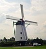
| (nl) Windmill De Korenbloem and Molenaarwoning |
Yes |
|
Bind |
Heerweg |
51 ° 07 ′ 40 ″ North, 5 ° 48 ′ 32 ″ is |
73170 |
|
| (nl) Windmill De Korenbloem and Molenaarwoning |
Yes |
|
Bind |
Heerweg 13 |
51 ° 07 ′ 40 ″ North, 5 ° 48 ′ 32 ″ is |
73170 |
|
| (nl) Long -standing farm |
|
|
Bind |
Heinestraat 14 |
51 ° 08 ′ 24 ″ North, 5 ° 46 ′ 10 ″ is |
73171 |
|
| (nl) HOVERHOF or HOVERHOF, Historical Hoeve |
|
|
Bind |
Hoverhofweg 1 |
51 ° 07 ′ 32 ″ North, 5 ° 47 ′ 18 ″ is |
73172 |
|
| (nl) HOVERHOF or HOVERHOF, Historical Hoeve |
|
|
Bind |
Hoverhofweg 2 |
51 ° 07 ′ 32 ″ North, 5 ° 47 ′ 18 ″ is |
73172 |
|
| (nl) Single village house |
|
|
Bind |
Lestraat 1 |
51 ° 07 ′ 39 ″ North, 5 ° 47 ′ 53 ″ is |
73173 |
|
| (nl) BELENHOF, Historical Hoeve |
|
|
Bind |
Lestraat 49 |
51 ° 07 ′ 29 ″ North, 5 ° 47 ′ 36 ″ is |
73175 |
|
| (nl) House of Hoeve |
|
|
Bind |
Lestraat 54 |
51 ° 07 ′ 30 ″ North, 5 ° 47 ′ 31 ″ is |
73176 |
|
| (nl) Wide -house |
|
|
Bind |
Maasstraat 2 |
51 ° 07 ′ 33 ″ North, 5 ° 48 ′ 09 ″ is |
73177 |
|
| (nl) Wide -house |
|
|
Bind |
Maasstraat 7 |
51 ° 07 ′ 34 ″ North, 5 ° 48 ′ 11 ″ is |
73178 |
|
| (nl) Single Burgerhuis |
|
|
Bind |
Maasstraat 8 |
51 ° 07 ′ 31 ″ North, 5 ° 48 ′ 12 ″ is |
73179 |
|
| (nl) Long -standing farm |
|
|
Bind |
Maasstraat 11 |
51 ° 07 ′ 34 ″ North, 5 ° 48 ′ 13 ″ is |
73180 |
|
| (nl) House Reynders |
Yes |
|
Bind |
Maasstraat 14 |
51 ° 07 ′ 32 ″ North, 5 ° 48 ′ 14 ″ is |
73181 |
|
| (nl) Walled plot |
Yes |
|
Bind |
Maasstraat |
51 ° 07 ′ 32 ″ North, 5 ° 48 ′ 16 ″ is |
73182 |
|
| (nl) Long -standing farm |
|
|
Bind |
Maasstraat 25 |
51 ° 07 ′ 35 ″ North, 5 ° 48 ′ 19 ″ is |
73183 |
|
| (nl) The Catholic School |
|
|
Bind |
Maasstraat 28 |
51 ° 07 ′ 33 ″ North, 5 ° 48 ′ 20 ″ is |
73184 |
|
| (nl) Long -standing farm |
|
|
Bind |
Maasstraat 45 |
51 ° 07 ′ 36 ″ North, 5 ° 48 ′ 25 ″ is |
73185 |
|
| (nl) Farm with separate ingredients |
|
|
Bind |
Maasstraat 50 |
51 ° 07 ′ 33 ″ North, 5 ° 48 ′ 27 ″ is |
73186 |
|
| (nl) House ? Gielen? |
Yes |
|
Bind |
Maasstraat 55 |
51 ° 07 ′ 36 ″ North, 5 ° 48 ′ 29 ″ is |
73187 |
|
| (nl) Inn Het Wit Paard or the Spaanjerd, Spaenjaert |
|
|
Bind |
Maasstraat 84 |
51 ° 07 ′ 26 ″ North, 5 ° 48 ′ 58 ″ is |
73188 |
|
| (nl) Village house with workshop (?) |
|
|
Bind |
Merrenhofstraat 5 |
51 ° 07 ′ 33 ″ North, 5 ° 48 ′ 04 ″ is |
73189 |
|
| (nl) Long -standing farm |
|
|
Bind |
Merrenhofstraat 29 |
51 ° 07 ′ 42 ″ North, 5 ° 47 ′ 53 ″ is |
73190 |
|
| (nl) Sniper |
|
|
Bind |
Raamijk 2 |
51 ° 08 ′ 03 ″ North, 5 ° 44 ′ 46 ″ is |
73191 |
|
| (nl) Parish church Sint-Servatius |
|
|
Bind |
Venlosesteenweg |
51 ° 07 ′ 34 ″ North, 5 ° 48 ′ 10 ″ is |
73192 |
|
| (nl) Dairy factory Holy Harlindis and Holy Relindis, now shop |
|
|
Bind |
Venlosesteenweg 115 |
51 ° 07 ′ 42 ″ North, 5 ° 48 ′ 09 ″ is |
73193 |
|
| (nl) Long -standing farm |
|
|
Bind |
Venlosesteenweg 45 |
51 ° 07 ′ 23 ″ North, 5 ° 48 ′ 04 ″ is |
73194 |
|
| (nl) Village |
|
|
Bind |
Venlosesteenweg 49 |
51 ° 07 ′ 25 ″ North, 5 ° 48 ′ 03 ″ is |
73195 |
|
| (nl) Citizen house |
|
|
Bind |
Venlosesteenweg 89 |
51 ° 07 ′ 33 ″ North, 5 ° 48 ′ 06 ″ is |
73196 |
|
| (nl) Rest (house) of a farm with separate components |
|
|
Bind |
Venlosesteenweg 153 |
51 ° 07 ′ 56 ″ North, 5 ° 48 ′ 12 ″ is |
73197 |
|
| (nl) Rest (house) of a farm with separate components |
|
|
Bind |
Venlosesteenweg 155 |
51 ° 07 ′ 56 ″ North, 5 ° 48 ′ 12 ″ is |
73197 |
|
| (nl) Rest (house?) From a semi-closed farm |
|
|
Bind |
Venlosesteenweg 156 |
51 ° 07 ′ 53 ″ North, 5 ° 48 ′ 16 ″ is |
73198 |
|
| (nl) Long -standing farm |
|
|
Bind |
Vennerweg 3 |
51 ° 07 ′ 17 ″ North, 5 ° 47 ′ 18 ″ is |
73199 |
|
| (nl) Chapel |
|
|
Bind |
Weertersteenweg 2 |
51 ° 07 ′ 53 ″ North, 5 ° 45 ′ 37 ″ is |
73200 |
|
| (nl) Long -standing farm |
|
|
Bind |
Weertersteenweg 67 |
51 ° 08 ′ 14 ″ North, 5 ° 45 ′ 13 ″ is |
73202 |
|
| (nl) Long -standing farm |
|
|
Kessenich |
Reservation 107 |
51 ° 08 ′ 35 ″ North, 5 ° 46 ′ 57 ″ is |
86077 |
|
| (nl) Mot van Kessenich, called Den Berg |
Yes |
|
Kessenich |
Church street |
51 ° 09 ′ 02 ″ North, 5 ° 49 ′ 27 ″ is |
86078 |
|
| (nl) Supply Chapel of the Baron Michiels van Kessenich family |
Yes |
|
Kessenich |
Church street |
51 ° 09 ′ 02 ″ North, 5 ° 49 ′ 27 ″ is |
86079 |
|
| (nl) Parish church Sint-Martinus |
Yes |
|
Kessenich |
Church street |
51 ° 09 ′ 02 ″ North, 5 ° 49 ′ 31 ″ is |
86080 |
|
| (nl) Copper pump from 1892 |
|
|
Kessenich |
Church street |
51 ° 09 ′ 04 ″ North, 5 ° 49 ′ 28 ″ is |
86081 |
|
| (nl) Long -standing farm |
|
|
Kessenich |
Church Street 5 |
51 ° 09 ′ 07 ″ North, 5 ° 49 ′ 29 ″ is |
86082 |
|
| (nl) Former town hall and school |
|
|
Kessenich |
Church Street 7 |
51 ° 09 ′ 05 ″ North, 5 ° 49 ′ 26 ″ is |
86083 |
|
| (nl) Corner house |
|
|
Kessenich |
Church Street 9 |
51 ° 09 ′ 05 ″ North, 5 ° 49 ′ 28 ″ is |
86084 |
|
| (nl) Rectory |
|
|
Kessenich |
Church Street 10 |
51 ° 09 ′ 05 ″ North, 5 ° 49 ′ 30 ″ is |
86085 |
|
| (nl) Cool, single village house with former farm building |
|
|
Kessenich |
Church Street 11 |
51 ° 09 ′ 04 ″ North, 5 ° 49 ′ 29 ″ is |
86086 |
|
| (nl) Single mansion |
|
|
Kessenich |
Venlosesteenweg 316 |
51 ° 08 ′ 52 ″ North, 5 ° 48 ′ 36 ″ is |
86087 |
|
| (nl) Single mansion of 1844 |
|
|
Kessenich |
Venlosesteenweg 391 |
51 ° 09 ′ 19 ″ North, 5 ° 48 ′ 42 ″ is |
86088 |
|
| (nl) Former customs office |
|
|
Kessenich |
Venlosesteenweg 403 |
51 ° 09 ′ 22 ″ North, 5 ° 48 ′ 45 ″ is |
86089 |
|
| (nl) Cast iron border posts from 1843 |
|
|
Kessenich |
Venlosesteenweg |
51 ° 09 ′ 32 ″ North, 5 ° 48 ′ 49 ″ is |
86090 |
|
| (nl) Long -standing farm |
|
|
Kinrooi |
Belestraat 19 |
51 ° 08 ′ 52 ″ North, 5 ° 43 ′ 11 ″ is |
86091 |
|
| (nl) Lemmensmole |
Yes |
|
Kinrooi |
Breeceenweg 230 |
51 ° 08 ′ 44 ″ North, 5 ° 44 ′ 53 ″ is |
86093 |
|
| (nl) Single Breedhuis |
|
|
Kinrooi |
Reservation 241 |
51 ° 08 ′ 43 ″ North, 5 ° 44 ′ 46 ″ is |
86094 |
|
| (nl) Single Burgerhuis |
|
|
Kinrooi |
Breeceenweg 280 |
51 ° 08 ′ 45 ″ North, 5 ° 44 ′ 26 ″ is |
86095 |
|
| (nl) Long -standing farm |
|
|
Kinrooi |
Weertersteenweg 177 |
51 ° 08 ′ 50 ″ North, 5 ° 44 ′ 29 ″ is |
86096 |
|
| (nl) Schreyvenhof |
|
|
Millbe |
Great Beersel 5 |
51 ° 10 ′ 32 ″ North, 5 ° 45 ′ 18 ″ is |
86099 |
|
| (nl) Hoeve Rutten |
|
|
Millbe |
Ruttenstraatje 2 |
51 ° 10 ′ 33 ″ North, 5 ° 43 ′ 44 ″ is |
86101 |
|
| (nl) Hoeve Biesenhof |
|
|
Millbe |
Vlasbrei 12 |
51 ° 10 ′ 13 ″ North, 5 ° 45 ′ 43 ″ is |
86244 |
|
| (nl) Long -standing farm |
|
|
Millbe |
Vlasbrei 14 |
51 ° 10 ′ 16 ″ North, 5 ° 45 ′ 50 ″ is |
86245 |
|
| (nl) Parish church Sint-Leonardus |
|
|
Millbe |
Weertersteenweg |
51 ° 10 ′ 12 ″ North, 5 ° 44 ′ 17 ″ is |
88667 |
|
| (nl) Chapel of Onze-Lieve-Vrouw van Lourdes |
Yes |
|
Millbe |
Weertersteenweg 345 |
51 ° 10 ′ 05 ″ North, 5 ° 44 ′ 17 ″ is |
88668 |
|
| (nl) Monastery and lower girls’ school of the Sisters of the Sacred Heart of Mary |
|
|
Millbe |
Weertersteenweg 363 |
51 ° 10 ′ 09 ″ North, 5 ° 44 ′ 14 ″ is |
88669 |
|
| (nl) Rectory |
|
|
Millbe |
Weertersteenweg 365 |
51 ° 10 ′ 09 ″ North, 5 ° 44 ′ 11 ″ is |
88670 |
”
|
| (nl) Villa; interbellum |
|
|
Millbe |
Weertersteenweg 395 |
51 ° 10 ′ 18 ″ North, 5 ° 44 ′ 09 ″ is |
88671 |
” |
| (nl) Long -standing farm |
|
|
Millbe |
Weertersteenweg 402 |
51 ° 10 ′ 22 ″ North, 5 ° 44 ′ 09 ″ is |
88672 |
|
| (nl) Villa ‘Pax’ |
|
|
Millbe |
Weertersteenweg 417 |
51 ° 10 ′ 25 ″ North, 5 ° 43 ′ 57 ″ is |
88673 |
|
| (nl) Customs office |
|
|
Millbe |
Weertersteenweg 504A |
51 ° 11 ′ 02 ″ North, 5 ° 43 ′ 33 ″ is |
88674 |
|
| (nl) Customs office |
|
|
Millbe |
Weertersteenweg 506 |
51 ° 11 ′ 02 ″ North, 5 ° 43 ′ 33 ″ is |
88674 |
|
| (nl) Customs office |
|
|
Millbe |
Weertersteenweg 508 |
51 ° 11 ′ 02 ″ North, 5 ° 43 ′ 33 ″ is |
88674 |
|
| (nl) Bunker 7 |
|
|
Millbe |
Weertersteenweg |
51 ° 09 ′ 39 ″ North, 5 ° 44 ′ 32 ″ is |
88675 |
|
| (nl) Lakerhof, Historical Hoeve |
|
|
Kessenich |
Lakerweg 4 |
51 ° 09 ′ 24 ″ North, 5 ° 47 ′ 52 ″ is |
88676 |
|
| (nl) ‘Donkerhoeve’ |
|
|
Millbe |
Shopping street 13 |
51 ° 09 ′ 45 ″ North, 5 ° 42 ′ 43 ″ is |
88677 |
|
| (nl) Apparent |
|
|
Bind |
Kessenicherweg |
51 ° 08 ′ 12 ″ North, 5 ° 48 ′ 39 ″ is |
88678 |
|
| (nl) Voorderkapel, Onze-Lieve-Vrouwekapel |
|
|
Bind |
Wieljestraat |
51 ° 07 ′ 48 ″ North, 5 ° 48 ′ 22 ″ is |
88679 |
|

Recent Comments