Josephine Falls – Wikipedia
From Wikipedia, the free encyclopedia
Waterfall in Far North Queensland, Australia
| Josephine Falls | |
|---|---|
Josephine Falls |
|

|
|
 |
|
| Location | Far North Queensland, Australia |
| Coordinates |
17°25′46″S 145°51′34″E / 17.42944°S 145.85944°ECoordinates: 17°25′46″S 145°51′34″E / 17.42944°S 145.85944°E[1][2] |
| Type | Tiered cascade |
| Elevation | 192 metres (630 ft) AHD [3] |
| Total height | 150–300 metres (490–980 ft)[3] |
| Number of drops | 3 |
| Watercourse | Josephine Creek |
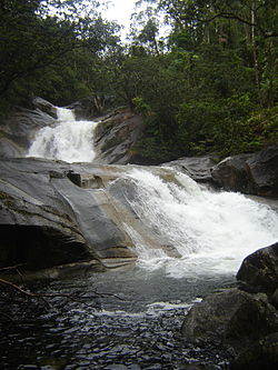
The Josephine Falls is a tiered cascade waterfall on the Josephine Creek located in Wooroonooran, Cairns Region in the Far North region of Queensland, Australia.
Location and features[edit]
The falls are situated at the foot of the southern face of Mount Bartle Frere in Wooroonooran National Park. They descend from the Atherton Tableland at an elevation of 192 metres (630 ft) above sea level[3] in the range of 150–300 metres (490–980 ft)[3] near a popular recreation site as the water flows over a large rock to form a natural waterslide on Josephine Creek, a tributary of the Russell River.
Access to falls is via a sealed road off the Bruce Highway between Babinda and Innisfail. The natural rock slide can be dangerous and the occasional flash flooding occurs without warning, with a sudden increase in the water volume.[4]
See also[edit]
References[edit]
- ^
“Josephine Falls (QLD)”. Gazetteer of Australia online. Geoscience Australia, Australian Government.
- ^ “Josephine Falls (entry 17365)”. Queensland Place Names. Queensland Government. Retrieved 13 September 2015.
- ^ a b c d “Map of Josephine Falls, QLD”. Bonzle Digital Atlas of Australia. Retrieved 23 May 2014.
- ^ “Josephine Falls”. World of Waterfalls. Johnny T Cheng. 17 May 2008. Retrieved 23 May 2014.
External links[edit]
![]() Media related to Josephine Falls at Wikimedia Commons
Media related to Josephine Falls at Wikimedia Commons
Recent Comments