Kunisaki – Wikipedia
From Wikipedia, the free encyclopedia
City in Kyushu, Japan
Kunisaki (国東市, Kunisaki-shi) is a small coastal city located in Ōita Prefecture, Kyushu, Japan. It is located on the Kunisaki Peninsula facing the Seto Inland Sea. Mostly covered by forests and farmlands, the peninsula is dotted with temples. The modern city of Kunisaki was founded on March 31, 2006, from the merger of the former town of Kunisaki, absorbing the towns of Aki, Kunimi and Musashi (all from Higashikunisaki District).[citation needed] As of March 31, 2017, the city has an estimated population of 29,098, with 13,223 households and a population density of 92/km2 (240/sq mi).[1] The total area is 317.84 km2 (122.72 sq mi).[citation needed]
Oita Airport is located in Kunisaki.
History[edit]
Nuclear-free zone[edit]
On June 25, 2008, the City of Kunisaki declared itself a ‘Nuclear-free Peace City” in wishing the abolition of nuclear weapons and world permanent peace.[2]
Geography[edit]
Located in northern Kyushu and the north east of Oita prefecture.
Mountains[edit]
- Mt. Futago (Futago-san) at 720m and the tallest
- Mt. Monju (Monju-san)
- Mt. Odomure
- Mt. Otake
- Mt. Takeshi Washinosu
- Mt. Fudo (or Hudo)
Climate[edit]
Kunisaki has a humid subtropical climate (Köppen climate classification Cfa) with hot summers and cool winters. Precipitation is significant throughout the year, but is somewhat lower in winter. The average annual temperature in Kunisaki is 16.2 °C (61.2 °F). The average annual rainfall is 1,641.6 mm (64.63 in) with June as the wettest month. The temperatures are highest on average in August, at around 27.3 °C (81.1 °F), and lowest in January, at around 6.1 °C (43.0 °F).[3] The highest temperature ever recorded in Kunisaki was 37.3 °C (99.1 °F) on 10 August 2013; the coldest temperature ever recorded was −7.9 °C (17.8 °F) on 8 January 2021.[4]
| Climate data for Kunimi, Kunisaki (1991−2020 normals, extremes 1977−present) | |||||||||||||
|---|---|---|---|---|---|---|---|---|---|---|---|---|---|
| Month | Jan | Feb | Mar | Apr | May | Jun | Jul | Aug | Sep | Oct | Nov | Dec | Year |
| Record high °C (°F) | 20.1 (68.2) |
24.1 (75.4) |
27.2 (81.0) |
29.9 (85.8) |
31.5 (88.7) |
34.0 (93.2) |
36.8 (98.2) |
37.3 (99.1) |
35.5 (95.9) |
31.6 (88.9) |
27.4 (81.3) |
27.0 (80.6) |
37.3 (99.1) |
| Average high °C (°F) | 9.9 (49.8) |
10.7 (51.3) |
14.1 (57.4) |
19.3 (66.7) |
23.9 (75.0) |
26.6 (79.9) |
30.7 (87.3) |
32.0 (89.6) |
28.3 (82.9) |
23.3 (73.9) |
17.8 (64.0) |
12.3 (54.1) |
20.7 (69.3) |
| Daily mean °C (°F) | 6.1 (43.0) |
6.6 (43.9) |
9.4 (48.9) |
14.1 (57.4) |
18.6 (65.5) |
22.2 (72.0) |
26.3 (79.3) |
27.3 (81.1) |
23.8 (74.8) |
18.7 (65.7) |
13.5 (56.3) |
8.4 (47.1) |
16.3 (61.3) |
| Average low °C (°F) | 2.4 (36.3) |
2.4 (36.3) |
4.8 (40.6) |
9.0 (48.2) |
13.8 (56.8) |
18.6 (65.5) |
22.9 (73.2) |
23.8 (74.8) |
20.2 (68.4) |
14.6 (58.3) |
9.4 (48.9) |
4.6 (40.3) |
12.2 (54.0) |
| Record low °C (°F) | −4.4 (24.1) |
−6.0 (21.2) |
−4.2 (24.4) |
0.4 (32.7) |
5.3 (41.5) |
9.7 (49.5) |
15.6 (60.1) |
16.4 (61.5) |
9.3 (48.7) |
4.6 (40.3) |
1.4 (34.5) |
−3.0 (26.6) |
−6.0 (21.2) |
| Average precipitation mm (inches) | 60.7 (2.39) |
70.2 (2.76) |
106.5 (4.19) |
123.2 (4.85) |
134.3 (5.29) |
274.6 (10.81) |
271.7 (10.70) |
154.1 (6.07) |
197.4 (7.77) |
113.5 (4.47) |
71.9 (2.83) |
63.5 (2.50) |
1,641.6 (64.63) |
| Average precipitation days (≥ 1.0 mm) | 8.3 | 8.7 | 10.1 | 9.5 | 9.1 | 13.0 | 11.0 | 8.7 | 9.9 | 6.7 | 7.6 | 8.7 | 111.3 |
| Mean monthly sunshine hours | 132.7 | 150.3 | 186.8 | 201.5 | 210.8 | 155.0 | 195.9 | 230.0 | 175.1 | 181.2 | 147.4 | 129.6 | 2,096.3 |
| Source: Japan Meteorological Agency[4][3] | |||||||||||||
| Climate data for Musashi, Kunisaki (2003−2020 normals, extremes 2003−present) | |||||||||||||
|---|---|---|---|---|---|---|---|---|---|---|---|---|---|
| Month | Jan | Feb | Mar | Apr | May | Jun | Jul | Aug | Sep | Oct | Nov | Dec | Year |
| Record high °C (°F) | 18.4 (65.1) |
23.7 (74.7) |
27.9 (82.2) |
27.0 (80.6) |
29.9 (85.8) |
34.2 (93.6) |
36.3 (97.3) |
36.3 (97.3) |
33.2 (91.8) |
32.2 (90.0) |
26.3 (79.3) |
24.2 (75.6) |
36.3 (97.3) |
| Average high °C (°F) | 9.9 (49.8) |
10.9 (51.6) |
13.6 (56.5) |
18.0 (64.4) |
21.8 (71.2) |
24.2 (75.6) |
28.0 (82.4) |
29.6 (85.3) |
27.1 (80.8) |
23.0 (73.4) |
17.9 (64.2) |
12.3 (54.1) |
19.7 (67.4) |
| Daily mean °C (°F) | 6.1 (43.0) |
7.0 (44.6) |
9.5 (49.1) |
13.8 (56.8) |
18.1 (64.6) |
21.4 (70.5) |
25.1 (77.2) |
26.7 (80.1) |
24.2 (75.6) |
19.5 (67.1) |
14.2 (57.6) |
8.5 (47.3) |
16.2 (61.1) |
| Average low °C (°F) | 1.9 (35.4) |
2.6 (36.7) |
5.0 (41.0) |
9.3 (48.7) |
14.2 (57.6) |
18.8 (65.8) |
22.8 (73.0) |
24.2 (75.6) |
21.3 (70.3) |
15.8 (60.4) |
10.1 (50.2) |
4.3 (39.7) |
12.5 (54.5) |
| Record low °C (°F) | −7.9 (17.8) |
−5.6 (21.9) |
−2.2 (28.0) |
0.5 (32.9) |
5.5 (41.9) |
11.8 (53.2) |
17.4 (63.3) |
18.0 (64.4) |
13.6 (56.5) |
8.0 (46.4) |
1.1 (34.0) |
−4.0 (24.8) |
−7.9 (17.8) |
| Average precipitation mm (inches) | 41.8 (1.65) |
65.8 (2.59) |
87.9 (3.46) |
122.8 (4.83) |
133.3 (5.25) |
269.2 (10.60) |
246.5 (9.70) |
130.0 (5.12) |
193.7 (7.63) |
123.3 (4.85) |
63.5 (2.50) |
57.9 (2.28) |
1,535.7 (60.46) |
| Average precipitation days (≥ 1.0 mm) | 5.9 | 7.9 | 8.5 | 9.0 | 8.2 | 12.4 | 10.5 | 7.6 | 9.3 | 6.3 | 6.4 | 7.0 | 99 |
| Source: Japan Meteorological Agency[5][6] | |||||||||||||
Geology[edit]
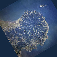
The Kunisaki Peninsula is formed from large conical volcanoes, including the 720-metre-tall (2,360 ft) Mt. Futago. Twenty-eight ravines radiate outward from the peninsula’s center.
Demographics[edit]
Per Japanese census data, the population of Kunisaki in 2020 is 26,232 people.[7] Kunisaki has been conducting censuses since 1920.
| Year | Pop. | ±% |
|---|---|---|
| 1950 | 65,370 | — |
| 1955 | 63,287 | −3.2% |
| 1960 | 58,786 | −7.1% |
| 1965 | 52,016 | −11.5% |
| 1970 | 46,521 | −10.6% |
| 1975 | 42,579 | −8.5% |
| 1980 | 40,504 | −4.9% |
| 1985 | 39,784 | −1.8% |
| 1990 | 37,771 | −5.1% |
| 1995 | 36,253 | −4.0% |
| 2000 | 35,425 | −2.3% |
| 2005 | 34,206 | −3.4% |
| 2010 | 32,007 | −6.4% |
| 2015 | 28,647 | −10.5% |
| 2020 | 26,232 | −8.4% |
| Kunisaki population statistics[7] | ||
Population data for Kunisaki, as of 30 September 2011[edit]
| Town | Male | Female | Total | No. of households |
|---|---|---|---|---|
| Kunisaki-machi | 5784 | 6435 | 12219 | 5153 |
| Kunimi-machi | 2287 | 2608 | 4895 | 2181 |
| Musashi-machi | 2716 | 2824 | 5540 | 2279 |
| Aki-machi | 4534 | 4869 | 9403 | 3826 |
| Totals | ||||
| Kunisaki-City | 15321 | 16736 | 32057 | 13439 |
Population distribution (2005 Census)[edit]

| National Population distribution by age(2005) | Age distribution by gender, for Kunisaki(2005) |
|---|---|
| ■ Purple – Kunisaki | ■ Blue – Men |
| ■ Green – Japan | ■ Red – Women |
Industry[edit]
The following major companies are based in Kunisaki.
- Canon Inc
- Sony Semiconductor Corporation
Education[edit]
Elementary schools[edit]
Kunisaki-machi[edit]
- Tomiku Elementary School
- Kunisaki Elementary School
- Owara Elementary School
- Asahi Elementary School
Musashi-machi[edit]
- Musashi Nishi Elementary School
- Musashi Higashi Elementary School
Aki-machi[edit]
- Aki Chuo Elementary School
- Aki Elementary School
Kunimi-machi[edit]
- Taketazu Elementary School
- Imi Elementary School
- Kumage SElementary School
Junior high schools[edit]
- Kunisaki Junior High School
- Musashi Junior High School
- Aki Junior High School
- Kunimi Junior High School
Transportation[edit]
Access[edit]
- 1 hr 30 mins by air from Tokyo Haneda airport to Oita airport
- 55 mins by air from Osaka Itami airport/Kansai International Airport to Oita airport
- 1 hr 10 mins from Nagoya Chubu International Airport to Oita airport
Tourism[edit]
Temples[edit]
- Futago-ji
- Monjusen-ji
- Senpuku-ji (also Sempuku-ji)
- Iwato-ji
- Ankoku-ji
- Joubutsu-ji
- Tomiku-ji
Notable people from Kunisaki[edit]
References[edit]
External links[edit]
Recent Comments