Beer, Devon – Wikipedia
From Wikipedia, the free encyclopedia
Village in Devon, England
Human settlement in England
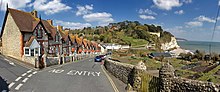
Beer is a village and civil parish in the East Devon district of Devon, England.[3] The village faces Lyme Bay and is a little over 1 mile (1.6 km) west of the town of Seaton. It is situated on the Jurassic Coast World Heritage Site and its picturesque cliffs, including Beer Head, form part of the South West Coast Path.[4][5]
At the 2011 Census, the parish had a population of 1,317.[6]
The village[edit]
Beer is mentioned in the Domesday Book of 1086, at which time it was located within Colyton hundred and had 28 households.[7] Its name is not derived from the drink, but from the Old English word bearu, meaning “grove” and referring to the original forestation that surrounded the village.[8]
It is a pretty coastal village that grew up around a smugglers’ cove and caves which were once used to store contraband goods. These are now part of the attraction of the village. Many of the buildings are faced with flint, a hard glassy stone found in the local chalk rock.[9]
Historically, the main sources of income for the village included fishing and lace production.[10] Boats are winched up the beach as there is no harbour, and fresh fish is sold nearby. Nowadays small electrically-driven winches using steel cables or tractors are located on the beach to haul boats in. Higher up is an old manual capstan operated by up to 20 men, now disused.
A brook winds its way in an open conduit alongside the main road down to the sea.
The shape of the coastline allowed local seafarers to operate in weather conditions when other towns could not, because it is protected from the prevailing westerly winds by Beer Head and the chalk cliffs which are the westernmost outcrop of limestone on the southwest coast. [11]

Nowadays, the sources of income are mainly tourism and fishing. Beer is also the home of the Pecorama (run by the PECO model railway manufacturer), which includes pleasure gardens and the Beer Heights Light Railway.
Beer has a steep pebble beach.
Beer is home to a cave complex, the Beer Quarry Caves, resulting from the quarrying of Beer stone. This stone has been prized since Roman times, because of its workability for carving and for its gentle yellow colour on exposure to air. Beer stone was used in the construction of 24 cathedrals [12] around the UK, including Exeter Cathedral, Westminster Abbey and St. Paul’s Cathedral, and was also used in the building of Christchurch Cathedral, St.Louis. Missouri, United States.
Bovey House, an Elizabethan manor house, is a mile inland.
Bacteria taken from cliffs at Beer on the south coast were launched to the International Space Station in 2008. The Beer microbes were placed on the European Space Agency’s (ESA) Technology Exposure Facility and were sent up still sitting on, and in, small chunks of cliff rock from the Jurassic Coast. After 553-days scientists found that many were still alive. The survivors are now reproducing in a laboratory. This was part of an experiment to study the survival of microbes (which naturally live on the stone) in extreme conditions. A new species of cyanobacteria was isolated at the Open University that could be used in future space settlements on the Moon and Mars to produce oxygen and break down rocks.[13]


Transport[edit]
Roads[edit]
Beer is just off the A3052 which links Exeter to the West and Lyme Regis to the East.
Public transport[edit]
Beer’s nearest railway station is Axminster railway station, around 9 miles (14 km) away, which is on the Exeter to Waterloo line. There is a bus link from the rail station to Beer.
The bus services in the village are provided by locally based AVMT Buses who run services to many of the nearby towns and villages including Seaton, Axminster, Branscombe, Sidmouth, and Colyton.
Notable people[edit]
References[edit]
- ^ “Hooken Cliffs – Walk – South West Coast Path”. www.southwestcoastpath.org.uk.
- ^ “Home – Beer Parish Council”. www.beerparishcouncil.org.uk.
- ^ “Beer, East Devon – area information, map, walks and more”. OS GetOutside. Ordnance Survey. Retrieved 11 January 2018.
- ^ “Beer Head, East Devon – area information, map, walks and more”. Ordnance Survey Get Outside. Retrieved 11 January 2018.
- ^ Lyme Regis & Bridport – OS Explorer Map 116 (Chard). United Kingdom: Ordnance Survey. 16 September 2015. p. 1. ISBN 9780319243176. Retrieved 11 January 2018.
- ^ “Beer (Parish): Key Figures for 2011 Census – Key Statistics”. Neighbourhood Statistics. Office for National Statistics. Retrieved 12 October 2016.
- ^ “Beer”. Open Domesday. Retrieved 12 October 2016.
- ^ Mills, A. D. (2011). A Dictionary of British Place-Names. Oxford University Press. ISBN 978-0-1996-0908-6.
- ^ “Flint Mining in Beer – Visit Beer, Devon”. Visit Beer, Devon. Retrieved 11 January 2018.
- ^ “Beer History”. beervillageheritage.org.uk.websitebuilder.prositehosting.co.uk. Retrieved 11 January 2018.
- ^ “East Devon Landscape Character Assessment” (PDF). eastdevon.gov.uk. Retrieved 13 July 2019.
- ^ Heptinstall, Simon (2008). Devon. Crimson Publishing. p. 111. ISBN 9781854584267.
- ^ Amos, Jonathan (23 August 2010). “Beer microbes live 553 days outside ISS”. BBC News. Retrieved 23 August 2010.
External links[edit]
Recent Comments