Recherche Archipelago – Wikipedia
Group of 105 islands in southern Western Australia
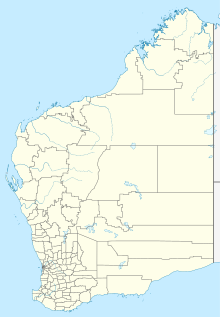


The Archipelago of the Recherche, known locally as the Bay of Isles,[1] is a group of 105 islands, and over 1200 “obstacles to shipping”, off the south coast of Western Australia. The islands stretch 230 km (140 mi) from east to west and to 50 km (31 mi) off-shore encompassing an area of approximately 4,000 square kilometres (1,544 sq mi).[2]
The western group is near Esperance and the eastern group at Israelite Bay. They are located in coastal waters, part of which is designated the Recherche Archipelago Nature Reserve.
History[edit]
Pre-European[edit]
Recherche Archipelago exhibits evidence of human occupation dated to 13,000 years ago. Archeologists have found ancient artefacts on Salisbury Island, a massive limestone remnant sitting on a granite dome 60 kilometres (37 mi) offshore, that included stone blades, lizard traps, axe heads, grinding stones and granite watering holes. The objects are believed to extend up to 13,000 years before present, from a time of lower sea levels when many of the islands were joined to the mainland.[3][4]
European discovery and naming[edit]
The islands became known to Europeans when François Thijssen and Pieter Nuyts, sailing on Gulden Zeepaert, charted the coast in 1627. George Vancouver also passed through the archipelago as part of his expedition in HMS Discovery in 1791.[5]
The area was named Archipelago of the Recherche (French: l’Archipel de la Recherche, IPA: [laʁʃipɛl də la ʁəʃɛʁʃ]) by Rear-admiral Antoine Bruni d’Entrecasteaux in 1792 during a French expedition in search of the vanished navigator Jean-François de Galaup, comte de Lapérouse. The name was taken from one of the admiral’s ships, Recherche (“Research”). The bay containing the current town of Esperance was named for his other ship, Espérance.
Matthew Flinders was the first to explore and chart the islands of the archipelago in 1802 as part of his voyage in the Investigator.[6]
Maritime history[edit]
Flinders abandoned two anchors when leaving Middle Island in 1803. These were found and recovered in 1973 by divers.[7] The bower anchor is on display at the South Australian Maritime Museum while the stream anchor can be seen at the National Museum of Australia.[8][9][10]
Sealers and whalers from other British colonies on the Australian continent frequented the area since at least the early 1820s.[11] Australia’s only recorded pirate, Black Jack Anderson, frequented the archipelago in the 1830s. A former whaler, he turned to piracy and wreaked havoc in the area until being murdered by his crew.[12][13]
Middle Island was regarded as the right whale hunting station of the bight in the 1830s and 1840s.[11]
The archipelago is recorded as the site of shipwrecks and other maritime incidents. The brig Belinda was wrecked off Middle Island while sealing in late 1824. The crew unsuccessfully attempted to reach Sydney in two boats, and were eventually rescued by the Nereus. The schooner Liberty salvaged the wreck the following year collecting metal stores and both the anchors.[14]The Mountaineer was sunk off Thistle Cove near Cape Le Grand in 1835 while attempting to find shelter from a gale.[15]The Rodondo was thought to be wrecked on Polloch Reef off Salisbury Island in 1895.[15] The SS Penguin was wrecked in 1920 off Middle Island while trying to shelter from a gale. The vessel was salvaged later the following year.[16] On 14 February 1991 the Sanko Harvest a bulk carrier of 33,024 tons sank in the archipelago – and it became the second largest wreck that can be dived on in the world.[17][18] The response to pollution caused by the wreck was reported upon soon after.[19]
Uses of the area now include recreational and commercial fishing, and shipping from the Port of Esperance. Commercial fishing is primarily for abalone, southern rock lobsters, pilchards, and sharks, and fishing tourism is an established industry. The area is proposed for other applications of aquaculture, including farming trials of bluefin tuna.[20]
Geography[edit]

The archipelago includes 105 features classed as islands, and more than 1500 islets.[6][21] The islands of the archipelago have a combined area of 9,720 hectares (24,019 acres).[22]
The islands are generally composed of granite outcrops, often with steep slopes and usually lacking beaches. A large number of features are submerged, some becoming exposed by tides.
The coast is subject to some of the most extreme wave energy in all of Australia, with the wave energy causing abrasion as far down as 100 metres (328 ft) during storms. The inner shelf of the archipelago has an average depth of 40 metres (131 ft) with most of the islands being in 60 metres (197 ft) of water.[23]Middle Island with an area of 1,080 hectares (2,669 acres) is the largest island in the Archipelago.[24]
Groups[edit]
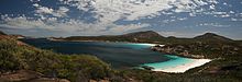
The islands are usually considered as being either in the western group, near Esperance and Woody Island and Cape Le Grand National Park, or in the eastern group where Middle Island is most prominent, near Cape Arid National Park.[25] Some surveys of the archipelago go further than the eastern and western distinction and consider groupings around named islands,[26] such as the Woody Group and the Remark Group.
Part of the area is included in the bioregion described as Esperance 2 (ESP2), the ‘Recherche subregion’, which contains Cape Le Grand National Park at its western end, and the Cape Arid National Park at the eastern end. This area is named the Recherche Archipelago Nature Reserve.
Islands[edit]
Tour operator Don MacKenzie was granted permission to land passengers on Woody Island in 1973. The MacKenzie family built the jetty that is still used for visitors to disembark from tourist boats.[27]
| Name | Location | Area (ha) | Notes |
|---|---|---|---|
| Anvil Island | 33°44′17″S 124°05′39″E / 33.73806°S 124.09417°E | 38 | A haul-out site for the Australian sea lion. |
| Barrier Island | 33°58′48″S 123°08′13″E / 33.98000°S 123.13694°E | 10 | Composed of gneiss and providing protection for some of the beaches near Cape Arid.[28] Also a haul-out site for the Australian sea lion. |
| Beaumont Island | 34°05′25″S 122°32′22″E / 34.09028°S 122.53944°E | 36 | Possible breeding site for the Australian sea lion |
| Bellinger Island | 33°53′09″S 123°38′36″E / 33.88583°S 123.64333°E | 38 | Possible breeding site for the Australian sea lion. The schooner Mary Ann was wrecked in 1876 while anchored under the lee of the island.[29] |
| Ben Island | 33°54′01″S 122°45′12″E / 33.90028°S 122.75333°E | 30 | Scientific research has been conducted on the island.[30] |
| Boxer Island | 34°00′02″S 121°40′42″E / 34.00056°S 121.67833°E | 162 | A haul-out site for the Australian sea lion.[31] |
| Capps Island | 33°59′19″S 121°40′55″E / 33.98861°S 121.68194°E | 35 | A haul-out site for the Australian sea lion. |
| Canning Island | 33°55′05″S 121°46′20″E / 33.91806°S 121.77222°E | 16 | Supports a population of 2000-3000 pairs of the white-faced storm-petrel. |
| Charley Island | 33°55′23″S 121°52′31″E / 33.92306°S 121.87528°E | 83 | Supports a small population of the bush rat.[32] |
| Cooper Island | 34°13′55″S 123°36′22″E / 34.23194°S 123.60611°E | 42 | A breeding site for the Australian sea lion and the New Zealand fur seal.[33] |
| Corbett Island | 34°07′05″S 121°58′40″E / 34.11806°S 121.97778°E | 84 | A haul-out site for the Australian sea lion. |
| Cranny Island | 33°43′51″S 124°04′40″E / 33.73083°S 124.07778°E | 4 | A haul-out site for the Australian sea lion. |
| Cull Island | 33°55′22″S 121°54′07″E / 33.92278°S 121.90194°E | 68 | Supports a population of 30 Cape Barren geese |
| Daw Island | 33°50′45″S 124°08′02″E / 33.84583°S 124.13389°E | 206 | A possible breeding site for the Australian sea lion. The island supports a small population of the bush rat[32] and is the only island in the archipelago to have a quenda colony.[34] The island is also known to be inhabited by Death Adder snakes. |
| Draper Island | 34°11′45″S 122°29′45″E / 34.19583°S 122.49583°E | 20 | A haul-out site for the Australian sea lion. |
| Figure of Eight Island | 34°01′37″S 121°36′25″E / 34.02694°S 121.60694°E | 233 | A possible breeding site for the Australian sea lion. |
| Finger Island | 34°06′17″S 122°20′38″E / 34.10472°S 122.34389°E | A possible breeding site for the Australian sea lion. | |
| Forrest Island | 33°54′59″S 122°42′38″E / 33.91639°S 122.71056°E | [35] | |
| Frederick Island | 34°04′02″S 122°00′19″E / 34.06722°S 122.00528°E | 77 | Supports 500-100 pairs flesh-footed shearwater and 5000-8000 pairs white-faced storm-petrel |
| Glennie Island | 34°05′45″S 123°06′18″E / 34.09583°S 123.10500°E | A possible breeding site for the Australian sea lion. | |
| Gulch Island | 34°01′31″S 123°14′50″E / 34.02528°S 123.24722°E | The granite island is approximately 2 kilometres (1 mi) in length and rises to a height of about 20 metres (66 ft). It is situated about 3 kilometres (2 mi) off-shore from the beaches west of Cape Arid.[28] | |
| Halfway Island | 33°46′12″S 124°02′24″E / 33.77000°S 124.04000°E | A possible breeding site for the Australian sea lion. Locally known as Ford Island. | |
| Hasler Island | 34°07′01″S 123°04′01″E / 34.11694°S 123.06694°E | A haul-out site for the Australian sea lion. | |
| Hastings Island | 34°06′05″S 122°07′01″E / 34.10139°S 122.11694°E | A haul-out site for the Australian sea lion. | |
| Hector Island | 34°00′00″S 121°43′01″E / 34.00000°S 121.71694°E | A haul-out site for the Australian sea lion. | |
| Helby Island | 34°07′01″S 123°04′01″E / 34.11694°S 123.06694°E | A haul-out site for the Australian sea lion. | |
| High North Island | 33°43′01″S 124°05′59″E / 33.71694°S 124.09972°E | A haul-out site for the Australian sea lion. | |
| Hood Island | 34°08′34″S 122°02′53″E / 34.14278°S 122.04806°E | 131 | Supports a small population of the bush rat.[32] |
| Hope Island | 34°04′44″S 122°09′46″E / 34.07889°S 122.16278°E | A haul-out site for the Australian sea lion. | |
| Hugo Island | 34°08′42″S 122°19′01″E / 34.14500°S 122.31694°E | A haul-out site for the Australian sea lion. | |
| Kermadec Island | 34°05′16″S 122°50′02″E / 34.08778°S 122.83389°E | Also known locally as Wedge Island, a breeding site for the Australian sea lion. | |
| Little Island | 34°27′25″S 121°59′23″E / 34.45694°S 121.98972°E | A breeding site for the Australian sea lion. | |
| Long Island | 34°02′57″S 121°57′42″E / 34.04917°S 121.96167°E | 138 | Supports hundreds of flesh-footed shearwater |
| Lorraine Island | 33°57′00″S 122°33′46″E / 33.95000°S 122.56278°E | 9 | Supports 2000-3000 pairs white-faced storm-petrel |
| MacKenzie Island | 34°12′01″S 122°06′43″E / 34.20028°S 122.11194°E | 48 | A breeding site for the Australian sea lion. |
| Manicom Island | 34°07′01″S 123°01′58″E / 34.11694°S 123.03278°E | A haul-out site for the Australian sea lion. | |
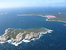
| Middle Island | 34°05′58″S 123°11′23″E / 34.09944°S 123.18972°E | 1080 | There have been historical activities on the island.[36][37] It is the largest island in the archipelago.[21] It was named by d’Entrecasteaux.[38] Matthew Flinders visited in January 1802 and climbed the 185 metres (607 ft) peak (subsequently named Flinders Peak) to survey the surrounding islands.[38] The island contains a pink lake, Lake Hillier, from which John Thistle, the Investigator‘s master, collected some salt samples.[38] The pirate, Black Jack Anderson, based himself on this island to launch raids on vessels making their way between Adelaide and Albany. The Belinda was wrecked off Middle Island in 1824, the SS Penguin was wrecked off the island while sheltering from a gale in 1920.[29] The island supports a population of the tammar wallaby and was thought to be home to the bush rat based on a single skull find in the 1970s however subsequent trips in 2008 and 2011 failed to find any evidence.[39][32] The island is 6.5 kilometres (4 mi) in length and approximately 9 kilometres (6 mi) off shore from Cape Arid.[11] |
| Mondrain Island | 34°08′14″S 122°14′45″E / 34.13722°S 122.24583°E | 810 | Supports a population of Recherche rock-wallabies, black-flanked rock-wallaby and the bush rat.[32] The highest point is Baudin Peak. (222 metres (728 ft)) |
| Nares Island | 33°56′01″S 122°35′35″E / 33.93361°S 122.59306°E | 6 | Known to have 3-4 pairs of white-faced storm-petrel |
| New Year Island | 33°51′21″S 124°07′37″E / 33.85583°S 124.12694°E | A haul-out site for the Australian sea lion. | |
| Nook Island | 33°46′22″S 124°05′59″E / 33.77278°S 124.09972°E | A breeding site for the Australian sea lion. | |
| North Twin Peak Island | 33°59′27″S 122°50′18″E / 33.99083°S 122.83833°E | Supports a small population of the bush rat.[32] | |
| Observatory Island | 33°55′27″S 121°47′31″E / 33.92417°S 121.79194°E | 101 | Captains Bruni d’Entrecasteaux and Huon de Kermandec sheltered on the lee side of this island in 1792 during a wild storm. While their ships, Le Recherche and L’Esperance, were at anchor, Captain d’Entrecasteaux decided to name the bay after the first ship to enter it – L’Esperance.[40] The island supports a colony of 20-30 pairs little penguins.[32] |
| Pasley Island | 34°00′39″S 123°31′55″E / 34.01083°S 123.53194°E | Also known as Paisley Island, a possible breeding site for the Australian sea lion. | |
| Passage Island | 33°58′58″S 122°25′58″E / 33.98278°S 122.43278°E | A haul-out site for the Australian sea lion. | |
| Pearson Island | 34°13′01″S 122°20′59″E / 34.21694°S 122.34972°E | A haul-out site for the Australian sea lion. | |
| Ram Island | 34°01′55″S 122°08′29″E / 34.03194°S 122.14139°E | 142 | Supports a colony of 300-500 pairs flesh-footed shearwater |
| Red Island | 33°52′15″S 121°20′59″E / 33.87083°S 121.34972°E | A haul-out site for the Australian sea lion. | |
| Remark Island | 34°03′52″S 121°59′03″E / 34.06444°S 121.98417°E | 101 | Ten nests of the black-faced cormorant are known on the island |
| Rocky Island | 34°04′58″S 120°52′01″E / 34.08278°S 120.86694°E | A breeding site for the Australian sea lion. | |
| Rodonia Island | 33°49′58″S 123°55′01″E / 33.83278°S 123.91694°E | A haul-out site for the Australian sea lion. | |
| Round Island | 34°06′17″S 123°53′16″E / 34.10472°S 123.88778°E | A breeding site for the Australian sea lion. | |
| Salisbury Island | 34°21′39″S 123°33′01″E / 34.36083°S 123.55028°E | 320 | A breeding ground for the Australian fur seal and the New Zealand fur seal. Also supports a population of the black-flanked rock-wallaby.[41] the bush rat.[32] |
| Sandy Hook Island | 34°02′04″S 121°59′32″E / 34.03444°S 121.99222°E | 285 | Flesh-footed shearwater common on this island. |
| Slipper Island | 34°02′45″S 122°45′10″E / 34.04583°S 122.75278°E | A possible breeding site for the Australian sea lion. | |
| Stanley Island | 34°01′02″S 123°17′27″E / 34.01722°S 123.29083°E | Also known as Wickham Island, a breeding site for the Australian sea lion. | |
| Tadpole Island | 33°43′58″S 124°01′58″E / 33.73278°S 124.03278°E | A haul-out site for the Australian sea lion. | |
| Taylor Island | 33°55′17″S 122°52′17″E / 33.92139°S 122.87139°E | A breeding site for the Australian sea lion. | |
| Termination Island | 34°28′15″S 121°59′31″E / 34.47083°S 121.99194°E | A possible breeding site for the Australian sea lion. | |
| Tizard Island | 34°01′01″S 122°40′58″E / 34.01694°S 122.68278°E | A haul-out site for the Australian sea lion. | |
| Westall Island | 34°04′50″S 122°58′03″E / 34.08056°S 122.96750°E | 70 | Supports a population of the Recherche rock-wallaby and black-flanked rock-wallaby[32] |
| Wickham Island | 34°01′16″S 123°17′23″E / 34.02111°S 123.28972°E | ||
| Wilson Island | 34°06′57″S 121°59′40″E / 34.11583°S 121.99444°E | 90 | Supports a population of Recherche the rock-wallaby[42] and black-flanked rock-wallaby[32] |
| Woody Island | 33°57′43″S 122°00′40″E / 33.96194°S 122.01111°E | 188 | The only island within the reserve with public access and usage. |
Flora and fauna[edit]
The area is a biodiversity hotspot with high biodiversity and a large number of species that are native to the region.[43] The environment contains a diverse array of subtropical and temperate flora and fauna. This is partly due to the Leeuwin current that flows in an easterly direction, this warms the cold seas to over 20 °C (68 °F) in summer.[23]
Larger islands have a substrate that supports vegetation, nesting birds, and other animals. A complex marine environment is found in the surrounding waters, the benthic habitat is various densities of seagrass meadows, reefs, or bare sand.
Marine[edit]
The waters around the islands meet often steep faces of granite, the extensive reefs and other features form habitat which supports a rich diversity of marine life. This includes 263 known species of fish, 347 known species of mollusc,[43] and over 450 types of sponge, sea grasses, and soft corals. A coral-like algae species, rhodoliths, form beds which support marine species of spiders, snails, and worms, also acting as a creche for scallops.[44] Marine mammals associated with the islands include two species of seal, large groups of common dolphins (Delphinus delphis), and minke whales (Balaenoptera acutorostrata).
Seagrasses found at the island include: Amphibolis antarctica, Amphibolis griffithii, Halophila decipiens, Halophila ovalis, Posidonia angustifolia, Posidonia australis, Posidonia coriacea, Posidonia denhartogii, Posidonia kirkmani, Posidonia ostenfeldii, Posidonia sinuosa, Syringodium isoetifolium, and Thalassodendron pachyrhizum.[45]
Terrestrial[edit]
The islands support populations of terrestrial flora and fauna, some of which are unique to the archipelago.
New Zealand fur seal (Arctocephalus forsteri) and Australian sea-lion (Neophoca cinerea) breeding colonies are found on some islands, with haul-out sites on many. Marsupials include tammars (Macropus eugenii derbianus), a species of bandicoot (Isoodon obesulus), and two subspecies of rock wallabies (Petrogale lateralis lateralis and Petrogale lateralis hacketti). Snakes include the Recherche Island dugite (Pseudonaja affinis tanneri) on Cull Island, and the python Morelia spilota imbricata. Other reptiles include the barking gecko (Underwoodisaurus milii), ornate dragon (Ctenophorus ornatus), and the southern heath monitor (Varanus rosenbergi). Two species of frog are also found on the islands; the quacking frog Crinia georgiana and spotted-thighed frog Litoria cyclorhyncha.:[46]
Many of the animals and plants are in refugia, where they are remote from factors that threaten mainland populations.[21]
Birds[edit]
The archipelago has been identified by BirdLife International as an Important Bird Area (IBA) because it is the only breeding site for the western subspecies of Cape Barren goose known as the Recherche Cape Barren goose. It also supports over 1% of the world populations of flesh-footed shearwaters, sooty oystercatchers, fairy terns and, probably, white-faced storm-petrels. Rock parrots (Neophema petrophila) and red-eared firetails (Stagonopleura oculata) have also been recorded.[47]
Gallery[edit]
References[edit]
- ^ “Archipelago of the Recherche”. Tourism Western Australia. Retrieved 19 June 2016.
- ^ Jack Jackson; Simon & Schuster (2008). Dive Atlas of the World. New Holland Publishers. ISBN 9781847733177.
- ^ Shaw, Stan (14 June 2016). “Isolated cave system off Esperance reveals vibrant underwater world and ancient Aboriginal history”. ABC News. Esperance, WA. Retrieved 7 June 2017.
- ^ Pownall, Angela (15 March 2012). “Island a precious time capsule”. The West Australian. Perth, WA. Retrieved 24 August 2014.
- ^ “Aquaculture Plan for the Recherche Archipelago” (PDF). 2000. Archived (PDF) from the original on 10 October 2007. Retrieved 11 October 2007.
- ^ a b “Marine Life Society of South Australia Inc. Newsletter September 2004”. 2004. Archived from the original on 31 August 2007. Retrieved 11 October 2007.
The Recherche Archipelago comprises some 105 islands and 1500 islets
- ^ Christopher, P. & Cundell, N. (editors), (2004), Let’s Go For a Dive, 50 years of the Underwater Explorers Club of SA, published by Peter Christopher, Kent Town, SA, pp.45–49. This describes the search and recovery of the anchors by members of the Underwater Explorers Club of South Australia
- ^ Christopher, P. & Cundell, N. (editors), (2004), Let’s Go For a Dive, 50 years of the Underwater Explorers Club of SA, published by Peter Christopher, Kent Town, SA, pp.48
- ^ ‘HM Sloop Investigator anchor,’ “HM Sloop Investigator anchor | SA Maritime Museum”. Archived from the original on 29 October 2013. Retrieved 25 October 2013., retrieved 16 July 2012.
- ^ Stream anchor from Matthew Flinders’ ship the ‘Investigator’, National Museum of Australia
- ^ a b c Alistair Paterson & Corioli Souter (April 2006). “Report on historical archeological expedition to Middle and Boxer Islands, Recherche Archipelago” (PDF). Western Australian Museum. Retrieved 24 August 2014.
- ^ Georgatas, G., “An 18,000-year old history uncovered on WA island”, National Indigenous Times, 20 June 2012, p. 14.
- ^ Clark, William Nairne (8 October 1842). “Remarks Respecting the Islands on the Coast of S.W. Australia”. The Perth Gazette and Western Australian Journal. p. 3. Retrieved 4 June 2019.
- ^ “Belinda (1824/06/17) Middle Island, Recherche Archipelago”. Western Australian Museum. Retrieved 24 August 2014.
- ^ a b Angela Pownall (18 April 2012). “Scanning for shipwrecks”. The West Australian. Yahoo7. Retrieved 24 August 2014.
- ^ Jeremy Green, Corioli Souter & Patrick Baker (21 May 2001). “Department of Maritime Archaeology Visit to Middle Island, Recherche Archipelago, Esperance, 29 April–4May 2001”. Government of Western Australia. Retrieved 24 August 2014.
- ^ (1994) Wreck has become a massive artificial reef. Second largest vessel in the world that can be dived Landscope, Winter 1994, pp. 23–27
- ^ (1995) Government declares 500-metre radius around the wreck a protected area for local marine life and recreational diving Western fisheries, May/June 1995, p.7
- ^ Western Australia. State Committee for Combating Marine Oil Pollution.(1991) Report on pollution response operations at Esperance from the wreck of the “Sanko Harvest” / by the State Committee for Combating Marine Oil Pollution; R.S. Purkiss, chairman. Fremantle, W.A : Dept of Marine & Harbours, 1991] no. DMH P4/91
- ^ “Project description”. Characterising the Fish habitats of the Recherche Archipelago. Fisheries Research and Development Corporation. Archived from the original on 21 July 2008.
- ^ a b c “Management Plan for Esperance Coastal Reserves Issues”. 2007. Archived from the original on 21 October 2007. Retrieved 14 October 2007.
- ^ “Naturebase – Esperance 2 (Recherche Subregion)” (PDF). 2007. Archived from the original (PDF) on 17 September 2007. Retrieved 14 October 2007.
- ^ a b “The sediments and environments of Recherche Archipelago, Southern Western Australia”. Geoscience Australia. 2013. Retrieved 24 August 2014.
- ^ “Pink Lake”. Tourism Australia. 2015. Retrieved 18 July 2015.
- ^ Smith, L.A., R.E. Johnstone and J. Dell.(2005) Vertebrate fauna of the Eastern Group, Recherche Archipelago, Western Australia Western Australian naturalist, Vol.24, no.4 (30 April 2005), p.232-246
- ^ Everall Consulting Biologist.(1999) Benthic habitat survey of the Remark, Mart, Mondrain, Tory and York Island groups in the Recherche Archipelago Perth, W.A. : Fisheries Western Australia, also known as Draft aquaculture plan for the Recherche Archipelago, Western Australia. February 1999
- ^ Rebecca Brewin (23 January 2015). “A look around the Recherche Archipelago”. Australian Broadcasting Corporation. Retrieved 4 June 2015.
- ^ a b Andrew D. Short (1 January 2005). Beaches of the Western Australian Coast – Eucla to Roebuck Bay: A Guide to Their Nature, Characteristics, Surf and Safety. Sydney University Press. ISBN 9780958650434.
- ^ a b Jeremy Green, Coriloi Souter & Patrick Baker (2001). “Department of Maritime Archeology visit to Middle Island, Recherche Archipelago, Esperance, 2001” (PDF). Western Australian Maritime Museum. Retrieved 8 November 2013.[permanent dead link]
- ^ Johnstone, R. E.(1988) Ben Island, Recherché Archipelago, Western Australia. Corella, vol.12 no.3 (October 1988), p.89-90
- ^ “Distribution of the Australian Sea Lion” (PDF). 2007. Retrieved 3 November 2013.[permanent dead link]
- ^ a b c d e f g h i j “IBAs – Recherche Archipelago”. Bird Life International. 2013. Retrieved 8 November 2013.
- ^ “Distribution of the Australian Sea Lion” (PDF). 2007. Archived from the original (PDF) on 29 August 2007. Retrieved 11 October 2007.
- ^ “The Recherche Archipelago a southern jewel” (PDF). Department of Environment and Conservation. 2012. Retrieved 21 March 2023.
- ^ Smith, L.A.(1988) Forrest Island, Recherché Archipelago, Western Australia. Corella, vol.12 no.3 (October 1988), pp. 91–92
- ^ Harvey, Clare.(2001) Archaeologists unravel mysteries of Middle Island. Esperance express, 14 Aug 2001, p.7.
- ^ Bindon, Peter.(1996) Report on a visit to Middle Island Recherche Archipelago, February 1996 Perth, W.A. Anthropology Dept., Western Australian Museum. Community report (Western Australian Museum. Anthropology Dept.) no. 1996/1.
- ^ a b c Flinders, Matthew (1966) [1814]. A Voyage to Terra Australis : undertaken for the purpose of completing the discovery of that vast country, and prosecuted in the years 1801, 1802, and 1803 in His Majesty’s ship the Investigator, and subsequently in the armed vessel Porpoise and Cumberland Schooner; with an account of the shipwreck of the Porpoise, arrival of the Cumberland at Mauritius, and imprisonment of the commander during six years and a half in that island (Facsimile ed.). Adelaide: Libraries Board of South Australia. pp. 200–202. Retrieved 30 January 2014.
- ^ “The Recherche Archipelago a southern jewel” (PDF). Department of Environment and Conservation. 2012. Retrieved 21 March 2023.
- ^ “Travel – Esperance”. The Sydney Morning Herald. 8 February 2004. Retrieved 11 October 2007.
- ^ “Petrogale lateralis lateralis – Black-flanked Rock-wallaby”. Department of Environment. 2007. Retrieved 11 October 2007.
- ^ “Petrogale lateralis hacketti – Recherche Rock-wallaby Glossary”. Department of Environment. 2007. Retrieved 11 October 2007.
- ^ a b “Marine bioregional plan for the South-west Marine Region – Draft for Consultation”. Department of the Environment. 2011. Retrieved 24 August 2014.
- ^ Robyn Williams (20 August 2005). “The Recherche Archipelago”. The Science Show. Australian Broadcasting Corporation. Archived from the original on 11 September 2005.
interview with Katrina Baxter
- ^ Kendrick, G.A., Harvey, E., Hill, J., McDonald, J.I. & Grove, S. (April 2002). “Review of existing information (appendix 1)” (PDF). Characterising the fish habitats of the Recherche Archipelago. School of Plant Biology, University of Western Australia. Archived from the original (PDF) on 21 July 2008.
APPENDIX SG1: Seagrass species found within the Recherche Archipelago region (after Campey et al., (2000); D.A. Lord & UWA (2001); Kirkman (1997); Walker, (1991); Waycott, (1998 & 2000)).
{{cite web}}: CS1 maint: multiple names: authors list (link) - ^ Browne-Cooper, R.; Bush, B.; Maryan, B.; Robinson, D. (2007). “Island species lists; Recherche Archipelago”. Reptiles and Frogs in the Bush: Southwestern Australia. University of Western Australia Press. p. 281. ISBN 978-1-920694-74-6.
- ^ “IBA: Recherche Archipelago”. Birdata. Birds Australia. Archived from the original on 6 July 2011. Retrieved 27 September 2011.
Further reading[edit]
- Australian Geographical Society (1952–1954). Expedition to the Recherché Archipelago, Western Australia. Australian Geographical Society reports. no.1 (7 reports in 4 volumes)
- pt. 1a. General history by J.M. Bechervaise—pt. 1b. Physiography by R.W. Fairbridge and V.N. Serventy—pt. 2. Birds by V.N. Serventy—pt. 3. Plants, 3a. Land flora by J.H. Willis, 3b. Marine algae by H.B.S. Womersley—pt. 4. Mammals by V. N. Serventy—pt. 5. Reptiles and frogs by L. Glauert—pt. 6. Spiders and opiliones by Barbara York Main—pt. 7. Molluscs (sea shells and snails) by J. Hope Macpherson.
- Kendrick, G. (et al.) (2005) Characterising the fish habitats of the Recherche Archipelago Crawley, W.A. University of Western Australia. Fisheries Research and Development Corporation. ISBN 1-74052-122-6 “Fisheries Research and Development Corporation report, project no. 2001/060.”
- Thomson-Dans, Carolyn, Kendrick, Gary and Bancroft, Kevin (2003) Researching the Recherche.Landscope (Como, W.A), Winter 2003, p. 6–8,
Early cartography[edit]
- Beautemps-Beaupré, C. F. (1807) Carte de l’archipel de la Recherche, situé à la partie occidentale de la terre de Nuyts, reconnu par le contre amiral Bruny-Dentrecasteaux, en décembre 1792 (an 1er de l’ere Française) Paris : Dépôt général des cartes et plans de la marine et des colonies], Battye Library Map Stack B/23/17 Scale [ca. 1:436,000] (Map of Recherche Archipelago showing track of Recherche and Espérance in December 1792). (Battye copy reduced to approximately 1:812,000 and 25 x 38.4 cm)
External links[edit]
Recent Comments