Zwalm – Wikipedia
From Wikipedia, the free encyclopedia
Municipality in Flemish Community, Belgium
|
Zwalm |
|
|---|---|
 |
|

Flag 
Coat of arms |
|
|
Location of Zwalm  |
|

Location in Belgium
Location of Zwalm in East Flanders  |
|
| Coordinates:
50°53′N 03°44′E / 50.883°N 3.733°ECoordinates: 50°53′N 03°44′E / 50.883°N 3.733°E |
|
| Country | |
| Community | Flemish Community |
| Region | Flemish Region |
| Province | East Flanders |
| Arrondissement | Oudenaarde |
| Government | |
| • Mayor | Bruno Tuybens (VoorZwalm) |
| • Governing party/ies | VoorZwalm, CD&V-Plus, N-VA |
| Area | |
| • Total | 33.88 km2 (13.08 sq mi) |
| Population | |
| • Total | 8,134 |
| • Density | 240/km2 (620/sq mi) |
| Postal codes |
9630, 9636 |
| Area codes | 055, 09 |
| Website | www.zwalm.be |
Zwalm (Dutch pronunciation: [ˈzʋɑl(ə)m] (![]() listen)) is a municipality located in Flanders, in the Flemish province of East Flanders, in Belgium. The municipality comprises the villages of Beerlegem, Dikkele, Hermelgem, Hundelgem, Meilegem, Munkzwalm, Nederzwalm, Paulatem, Roborst, Rozebeke, Sint-Blasius-Boekel, Sint-Denijs-Boekel and Sint-Maria-Latem. In 2021, Zwalm had a total population of 8,244. The total area is 33.82 km2.[2]
listen)) is a municipality located in Flanders, in the Flemish province of East Flanders, in Belgium. The municipality comprises the villages of Beerlegem, Dikkele, Hermelgem, Hundelgem, Meilegem, Munkzwalm, Nederzwalm, Paulatem, Roborst, Rozebeke, Sint-Blasius-Boekel, Sint-Denijs-Boekel and Sint-Maria-Latem. In 2021, Zwalm had a total population of 8,244. The total area is 33.82 km2.[2]
Gallery[edit]
-

-
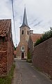
Hundelgem, church: Sint-Amanduskerk
-

Vinkemolen Wind Mill in Franskouter, Sint-Denijs-Boekel
-
References[edit]
- ^
“Wettelijke Bevolking per gemeente op 1 januari 2018”. Statbel. Retrieved 9 March 2019.
- ^ “Bevolking per statistische sector – Sector 45065”. Statistics Belgium. Retrieved 8 May 2022.
External links[edit]
Our servers are currently under maintenance or experiencing a technical problem.
Please try again in a few minutes.
See the error message at the bottom of this page for more information.
Recent Comments