Büyük Qaralez – Wikipedia
From Wikipedia, the free encyclopedia
Place in Crimea
|
Büyük Qaralez/Krasny Mak Büyük Qaralez/Буюк Къаралез/Красный Мак |
|
|---|---|
 |
|
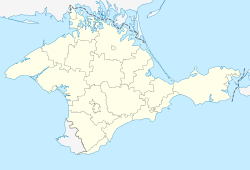
Büyük Qaralez/Krasny Mak Location of Büyük Qaralez within Crimea |
|
| Coordinates:
44°38′38″N 33°46′51″E / 44.64389°N 33.78083°ECoordinates: 44°38′38″N 33°46′51″E / 44.64389°N 33.78083°E |
|
| Country | Disputed |
| Republic | Crimea |
| District | Bakhchysarai Raion |
| Elevation | 120 m (390 ft) |
| Population
(2014) |
|
| • Total | 1,663 |
| Time zone | UTC+4 (MSK) |
| Postal code |
98464 |
| Area code | +380-6554 |
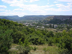
Büyük Qaralez (Буюк Къаралез in Cyrillic, detatarized name is Krasny Mak; Russian: Красный Мак) is a selo in Bakhchysarai Raion of the Autonomous Republic of Crimea, a disputed territory recognized by a majority of countries as part of Ukraine and incorporated by Russia as the Republic of Crimea. It is located in the Crimean Mountains, southerly of Bakhchysarai. The village stretches along the Bystryanka creek, a tributary of the river Belbek. Population: 1,663 (2014 Census).[1]
Near the village are the medieval hillforts of Mangup and Eski-Kermen. During the Soviet period, the area became a local center, where blocks of flats have been constructed.
References[edit]
- ^
Russian Federal State Statistics Service (2014). “Таблица 1.3. Численность населения Крымского федерального округа, городских округов, муниципальных районов, городских и сельских поселений” [Table 1.3. Population of Crimean Federal District, Its Urban Okrugs, Municipal Districts, Urban and Rural Settlements]. Федеральное статистическое наблюдение «Перепись населения в Крымском федеральном округе». (“Population Census in Crimean Federal District” Federal Statistical Examination) (in Russian). Federal State Statistics Service. Retrieved January 4, 2016.
Recent Comments