Eastmain River – Wikipedia
From Wikipedia, the free encyclopedia
River in Quebec, Canada
| Eastmain | |
|---|---|
 |
|
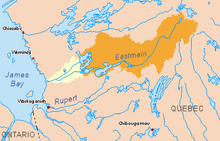
Eastmain River original basin in yellow and orange. Diverted basin in orange. |
|
| Country | Canada |
| Province | Quebec |
| Region | Jamésie |
| Source | Lac Bréhat |
| • location | Baie-James, Nord-du-Québec, Québec, Canada |
| • coordinates | 52°31′30″N 70°52′00″W / 52.52500°N 70.86667°W |
| • elevation | 554 m (1,818 ft) |
| Mouth | James Bay |
|
• location |
Eastmain, Nord-du-Québec, Quebec, Canada |
|
• coordinates |
52°14′30″N 78°34′00″W / 52.24167°N 78.56667°WCoordinates: 52°14′30″N 78°34′00″W / 52.24167°N 78.56667°W |
|
• elevation |
0 m (0 ft) |
| Length | 756 km (470 mi)[1] |
| Basin size | 46,400 km2 (17,900 sq mi)[1] |
| Discharge | |
| • average | 930 m3/s (33,000 cu ft/s)[1] |
| Tributaries | |
| • left |
|
| • right |
|
The Eastmain River, formerly written East Main, is a river in west central Quebec. It rises in central Quebec and flows 800 km (500 mi) west to James Bay, draining an area of 46,400 km2 (17,900 sq mi). The First Nations Cree village of Eastmain is located beside the mouth.
Eastmain is a compounding of the river’s former name East Main,[2] which was taken from the former Hudson’s Bay Company outpost at its mouth, which controlled the its operations in the East Main District on the eastern side of James Bay.
Geography[edit]
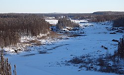
Since the late 1980s, most of the waters of the Eastmain River have been diverted and flow northwards through the Opinaca Reservoir, with a surface area of about 950 square kilometres (370 sq mi), and into the Robert-Bourassa Reservoir of Hydro-Québec’s La Grande Complex. The remainder of the Eastmain River contains only about 10 percent of the volume of its former flow, and is now subject to freeze-up in winter (see photo). These changes have affected the Cree and Inuit peoples who live along the Eastmain River and James Bay coast.
A further hydroelectric project on the upper Eastmain River was under construction in 2005. The project was part of the original hydroelectric project provided for by the James Bay and Northern Quebec Agreement of 1975. The Eastmain Reservoir will eventually have a surface area of about 600 square kilometres (230 sq mi), and the Eastmain-1 power plant will generate a maximum of 900 MW.

History[edit]
The mouth of the Eastmain was a centre of the Hudson’s Bay Company fur trade. Charles Bayly reached it from Rupert House in the 1670s. After Rupert House was destroyed in 1686, the area was visited by a ship from York Factory. In 1723 to 1724, Joseph Myatt of the Hudson’s Bay Company built a post.[3]
See also[edit]
References[edit]
- ^ a b c Atlas of Canada Archived February 2, 2007, at the Wayback Machine (all values of original river prior to hydro-electric development.)
- ^ Low, Albert Peter (1896), Report on Explorations in the Labrador Peninsula along the East Main, Koksoak, Hamilton, Manicuagan, and Portions of Other Rivers in 1892-93-94-95, Geological Survey of Canada, Ottawa: S.E. Dawson.
- ^ Arthur S Morton, A History of the Canadian West to 1870-71, no date, circa 1950
Recent Comments