De Witt Municipal Airport – Wikipedia
From Wikipedia, the free encyclopedia
Airport
|
De Witt Municipal Airport |
|||||||||||
|---|---|---|---|---|---|---|---|---|---|---|---|
 |
|||||||||||
| Summary | |||||||||||
| Airport type | Public | ||||||||||
| Owner | City of De Witt | ||||||||||
| Serves | De Witt, Arkansas | ||||||||||
| Elevation AMSL | 190 ft / 58 m | ||||||||||
| Coordinates |
34°15′44″N 091°18′27″W / 34.26222°N 91.30750°W / 34.26222; -91.30750Coordinates: 34°15′44″N 091°18′27″W / 34.26222°N 91.30750°W / 34.26222; -91.30750 |
||||||||||
| Map | |||||||||||
 Location of airport in Arkansas |
|||||||||||
| Runways | |||||||||||
|
|||||||||||
| Statistics (2016) | |||||||||||
|
|||||||||||


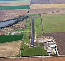
De Witt Municipal Airport (FAA LID: 5M1) is a public use airport in Arkansas County, Arkansas, United States.[1] It is owned by the City of De Witt (or DeWitt) and located three nautical miles (6 km) southeast of its central business district.[1] This airport is included in the National Plan of Integrated Airport Systems for 2011–2015, which categorized it as a general aviation facility.[2]
Facilities and aircraft[edit]
De Witt Municipal Airport covers an area of 79 acres (32 ha) at an elevation of 190 feet (58 m) above mean sea level. It has one runway designated 18/36 with an asphalt surface measuring 3,204 by 60 feet (977 x 18 m).[1]
For the 12-month period ending August 31, 2016, the airport had 51,100 aircraft operations, an average of 140 per day: 99.8% general aviation and 0.2% military. At that time there were 18 single-engine aircraft based at this airport.[1]
References[edit]
- ^ a b c d e FAA Airport Form 5010 for 5M1 PDF. Federal Aviation Administration. Effective July 19, 2018.
- ^
“2011–2015 NPIAS Report, Appendix A” (PDF). National Plan of Integrated Airport Systems. Federal Aviation Administration. October 4, 2010. Archived from the original (PDF, 2.03 MB) on 2012-09-27.
External links[edit]

Recent Comments