National Register of Historic Places listings in Nebraska
From Wikipedia, the free encyclopedia
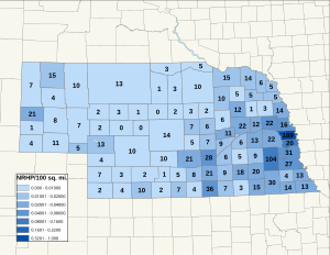
This is a list of more than 1,100 properties and districts in Nebraska that are on the National Register of Historic Places. Of these, 20 are National Historic Landmarks. There are listings in 90 of the state’s 93 counties.
This National Park Service list is complete through NPS recent listings posted March 31, 2023.[1]
Current listings by county[edit]

There are no properties listed on the National Register of Historic Places in Blaine County.
| [3] | Name on the Register[4] | Image | Date listed[5] | Location | City or town | Description |
|---|---|---|---|---|---|---|
| 1 | Albion Carnegie Library | March 25, 2019 (#100003569) |
437 S. 3rd St. 41°41′21″N 97°59′59″W / 41.6891°N 97.9997°W |
Albion | ||
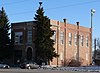
| 2 | Cedar Rapids City Hall and Library |
 |
July 1, 1994 (#94000654) |
423 W. Main St. 41°33′35″N 98°08′56″W / 41.5598°N 98.1489°W |
Cedar Rapids | 1913 multi-function municipal hall featuring Italian Renaissance Revival architecture.[10] |
| 3 | Petersburg Jail |
 |
March 15, 2005 (#05000154) |
Main St. and 2nd St. 41°51′15″N 98°04′47″W / 41.8541°N 98.0798°W |
Petersburg | 1902 brick jail, Petersburg’s first freestanding municipal structure, reflecting an early interest in public safety.[11] |
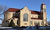
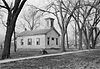
| 4 | St. Anthony’s Church and School |
 |
March 9, 2000 (#00000172) |
514 W. Main St. and 103 N 6th St. 41°33′37″N 98°09′05″W / 41.5604°N 98.1513°W |
Cedar Rapids | 1911 Georgian Revival Catholic school and 1918 Romanesque Revival church.[12] |
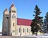
| 5 | St. Bonaventure Church Complex |
 |
October 19, 1982 (#82000598) |
Off Nebraska Highway 14 41°53′44″N 98°03′06″W / 41.8956°N 98.0517°W |
Raeville | German-Catholic religious complex comprising a 1910 three-story school, 1917 Romanesque Revival church, 1920 Colonial Revival rectory, parish hall, cemetery, and orchard.[13] |
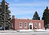
| 6 | US Post Office-Albion |
 |
May 11, 1992 (#92000475) |
310 W. Church St. 41°41′32″N 98°00′01″W / 41.6921°N 98.0002°W |
Albion | One of 12 Nebraska post offices featuring a Section of Fine Arts mural, “Nebraska in Winter” (1939) by Jenne Magafan.[14] |
| [3] | Name on the Register[4] | Image | Date listed[5] | Location | City or town | Description |
|---|---|---|---|---|---|---|
| 1 | Lynch Archeological Site | December 2, 1974 (#74001101) |
Address Restricted | Lynch | Site of a large earth lodge village occupied 1450–1550 CE, a rare Nebraskan example of a type mostly found in South Dakota.[19] | |
| 2 | Ponca Agency | July 12, 2006 (#06000554) |
Address Restricted | Niobrara | Site of the federal agency that administered the Ponca Reservation from 1859–1877, listed for its possible archaeological evidence of a major transitional time in Ponca history.[19] | |
| 3 | SS Peter & Paul Catholic School |
 |
January 7, 1992 (#91001751) |
Southeastern corner of the junction of 2nd and Broadway Sts. 42°54′54″N 98°51′10″W / 42.9150°N 98.8528°W |
Butte | 1909 parochial school designed by William L. Steele, a typical example of such schools built in many Catholic communities of Nebraska in the early 20th century.[20] |
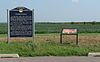
| 4 | The Tower |
 |
December 29, 2004 (#04001413) |
East of Gross, near the Missouri River[21] 42°56′09″N 98°28′41″W / 42.9358°N 98.4781°W |
Lynch | Also called Old Baldy, a 100-foot (30 m) unvegetated hill where the Lewis and Clark Expedition made the first scientific descriptions of the geologically unusual landmark and of prairie dogs, on September 7, 1804.[22] |
| 5 | White Horse Ranch |
 |
July 5, 1990 (#90000984) |
Southeast of Naper between the Keya Paha and Niobrara Rivers 42°52′30″N 99°03′34″W / 42.8751°N 99.0595°W |
Naper | 1936 ranch where the American Albino color breed of horses originated, now the American creme and white horse registry.[23] |
Former listings[edit]
| [3] | Name on the Register[4] | Image | Date listed[5] | Location | City or town | Description |
|---|---|---|---|---|---|---|
| 1 | Ben Bonderson Farm |
 |
November 8, 2006 (#06000993) |
1541 270th St. 42°16′45″N 96°38′30″W / 42.279167°N 96.641667°W |
Emerson | Well-preserved family farm with eight buildings and two structures dating back to 1883.[31] |
| 2 | Emmanuel Lutheran Church |
 |
October 15, 1969 (#69000129) |
1500 Hickory St. 42°24′45″N 96°25′04″W / 42.41254°N 96.4177°W |
Dakota City | One of Nebraska’s oldest known churches, built in 1860 as the state’s first Lutheran house of worship and one of its only Greek Revival churches of any denomination.[32] |
| 3 | Homer Site |
 |
August 14, 1973 (#73001058) |
Junction of U.S. Route 77 and Omaha Creek, northeast of Homer[33] 42°19′44″N 96°28′48″W / 42.328889°N 96.480000°W |
Homer | Site of Ton-won-tonga, the principal village of the Omaha people, occupied on and off from 1775 to 1845, bastion of indigenous control over trade on the Upper Missouri River.[34] |
| 4 | Meisch House |
 |
March 13, 1986 (#86000387) |
213 17th St. 42°28′26″N 96°24′54″W / 42.47386°N 96.415088°W |
South Sioux City | Square brick house built in 1888.[35] |
| 5 | Cornelius O’Connor House |
 |
November 23, 1977 (#77000826) |
F Ave. and Blyburg Rd.[36] 42°18′40″N 96°27′45″W / 42.311224°N 96.462581°W |
Homer | c. 1875 Italianate house of a carpenter, with interior woodwork done by O’Connor in dark walnut.[37] |
| [3] | Name on the Register[4] | Image | Date listed[5] | Location | City or town | Description |
|---|---|---|---|---|---|---|
| 1 | Cook Blacksmith Shop |
 |
December 27, 1974 (#74001106) |
204 3rd St. 42°33′45″N 96°42′27″W / 42.5625°N 96.7075°W |
Ponca | |
| 2 | Dixon County Courthouse |
|
January 10, 1990 (#89002247) |
3rd and Iowa Sts. 42°33′46″N 96°42′32″W / 42.562778°N 96.708889°W |
Ponca | |
| 3 | Emerson City Park | March 5, 2018 (#100002165) |
Square block between 4th, 5th, Main & Logan Sts. 42°16′55″N 96°43′37″W / 42.282068°N 96.726906°W |
Emerson | ||
| 4 | Indian Hill Archeological District | July 6, 1984 (#84002460) |
Address Restricted | New Castle | ||
| 5 | Ponca Historic District |
 |
May 18, 1979 (#79001438) |
Roughly bounded by East, Court, 2nd, and 3rd Sts. 42°33′51″N 96°42′27″W / 42.564167°N 96.7075°W |
Ponca | |
| 6 | Swedish Evangelical Lutheran Salem Church |
 |
February 1, 1983 (#83001088) |
Off Nebraska Highway 35 42°16′02″N 96°51′46″W / 42.267222°N 96.862778°W |
Wakefield |
Former listings[edit]
Former listings[edit]
Alma Carnegie Library,
111 North John St.,
Alma, MP100007149,
LISTED, 11/8/2021
| [3] | Name on the Register[4] | Image | Date listed[5] | Location | City or town | Description |
|---|---|---|---|---|---|---|
| 1 | Alma Carnegie Library |
 |
November 8, 2021 (#100007149) |
111 North John St. 40°05′57″N 99°21′44″W / 40.0991°N 99.3622°W |
Alma | |
| 2 | Alma City Auditorium and Sale Barn |
 |
July 11, 2014 (#14000395) |
800 block West Main Street[46] 40°05′50″N 99°21′50″W / 40.0972°N 99.3640°W |
Alma | |
| 3 | Hotel Orleans |
 |
February 24, 2021 (#100006193) |
101 East Pine St. 40°07′48″N 99°27′17″W / 40.1300°N 99.4548°W |
Orleans | |
| 4 | Prairie Dog Creek Bridge |
 |
June 29, 1992 (#92000712) |
Township road over Prairie Dog Creek, 8.5 miles south and 1 mile west of Orleans 40°00′16″N 99°28′48″W / 40.0044°N 99.48°W |
Orleans | |
| 5 | Cordelia Bennett Preston Memorial Library | February 24, 2021 (#100006192) |
510 South Orleans Ave. 40°07′43″N 99°27′18″W / 40.1285°N 99.4550°W |
Orleans | ||
| 6 | Sappa Creek Bridge |
 |
June 29, 1992 (#92000713) |
County road over Sappa Creek, 2 miles east of Stamford 40°07′53″N 99°33′17″W / 40.1314°N 99.5547°W |
Stamford | |
| 7 | Turkey Creek Bridge |
|
June 29, 1992 (#92000711) |
County road over Turkey Creek, 2 miles west and 1 mile south of Ragan 40°17′33″N 99°19′57″W / 40.2925°N 99.3325°W |
Ragan |
Former listings[edit]
Former listings[edit]
There are no properties listed on the National Register of Historic Places in Logan County.
There are no properties listed on the National Register of Historic Places in McPherson County.
Former listing[edit]
| [3] | Name on the Register[4] | Image | Date listed[5] | Location | City or town | Description |
|---|---|---|---|---|---|---|
| 1 | Athletic Park Band Shell |
 |
November 12, 1992 (#92001573) |
Northwestern corner of the junction of Harper and Main Sts. 42°21′15″N 97°47′34″W / 42.354167°N 97.792778°W |
Plainview | |
| 2 | Fremont, Elkhorn and Missouri Valley Railroad Depot |
|
November 16, 2005 (#05001291) |
304 S. Main St. 42°20′53″N 97°47′36″W / 42.348056°N 97.793333°W |
Plainview | |
| 3 | Meridian Highway |
 |
November 29, 2001 (#01001273) |
4.5 miles along county roads, following 552 Ave., 853 Rd., and 551 Ave. 42°10′43″N 97°29′28″W / 42.178611°N 97.491111°W |
Pierce | |
| 4 | Plainview Carnegie Library |
 |
February 25, 1993 (#93000056) |
102 S. Main St. 42°21′02″N 97°47′36″W / 42.350556°N 97.793333°W |
Plainview | |
| 5 | Willow Creek Bridge |
|
June 29, 1992 (#92000706) |
County road over Willow Creek, 6.5 miles south of Foster 42°10′38″N 97°40′01″W / 42.177222°N 97.666944°W |
Foster | Bridge moved to Gilman Park in Pierce, Nebraska in 1994.[54] |
Former listing[edit]
Former listings[edit]
Former listings[edit]
| [3] | Name on the Register | Image | Date listed | Date removed | Location | City or town | Description |
|---|---|---|---|---|---|---|---|
| 1 | York County Courthouse | December 6, 1975 (#75001103) |
June 5, 1978 | 5th St. and Lincoln Ave. | York | Demolished in 1978. |
See also[edit]
References[edit]
- ^ National Park Service, United States Department of the Interior, “National Register of Historic Places: Weekly List Actions”, retrieved March 31, 2023.
- ^ The following sites are listed in multiple counties: Carns State Aid Bridge (Keya Paha and Rock), Champe-Fremont 1 Archeological Site (Douglas and Sarpy), Deering Bridge (Clay and Fillmore), Fort Robinson and Red Cloud Agency (Dawes and Sioux), Frank Parker Archeological Site (Douglas and Washington), Palmer Site (Howard and Merrick), Site No. JF00-072 (Jefferson and Thayer), Spade Ranch (Cherry and Sheridan) and Sweetwater Archeological Site (Buffalo and Sherman).
- ^ a b c d e f g h i j k l m n o p q r s t u v w x y z aa ab ac ad ae af ag ah ai aj ak al am an ao ap aq ar as at au av aw ax Numbers represent an alphabetical ordering by significant words. Various colorings, defined here, differentiate National Historic Landmarks and historic districts from other NRHP buildings, structures, sites or objects.
- ^ a b c d e f g h i j k l m n o p q r s t u v w x y z aa ab ac ad ae af ag ah ai aj ak al am an ao
“National Register Information System”. National Register of Historic Places. National Park Service. March 13, 2009.
- ^ a b c d e f g h i j k l m n o p q r s t u v w x y z aa ab ac ad ae af ag ah ai aj ak al am an ao The eight-digit number below each date is the number assigned to each location in the National Register Information System database, which can be viewed by clicking the number.
- ^ Long, Barbara Beving (1989-11-08). “National Register of Historic Places Registration Form: First Arthur County Courthouse and Jail” (PDF). Archived from the original on June 9, 2011. Retrieved 2013-01-25.
{{cite journal}}: Cite journal requires|journal=(help)CS1 maint: unfit URL (link) - ^ Spencer, Janet Jeffries (May 1979). “National Register of Historic Places Registration Form: Pilgrim Holiness Church” (PDF). Archived from the original on June 9, 2011. Retrieved 2013-01-25.
{{cite journal}}: Cite journal requires|journal=(help)CS1 maint: unfit URL (link) - ^ “C. C. Hampton Homestead (Warner Ranch)”. National Park Service. Retrieved 2012-05-28.
- ^ Spencer, Janet Jeffries (September 1984). “National Register of Historic Places Registration Form: C. C. Hampton Homestead” (PDF). Archived from the original on September 10, 2011. Retrieved 2013-01-27.
{{cite journal}}: Cite journal requires|journal=(help)CS1 maint: unfit URL (link) - ^ Waymire, Phyllis (February 1994). “National Register of Historic Places Registration Form: Cedar Rapids City Hall and Library” (PDF). Archived from the original on October 8, 2020. Retrieved 2013-01-27.
{{cite journal}}: Cite journal requires|journal=(help)CS1 maint: unfit URL (link) - ^ Miller, Greg (December 2004). “National Register of Historic Places Registration Form: Petersburg Jail” (PDF). Archived from the original on June 20, 2010. Retrieved 2013-01-28.
{{cite journal}}: Cite journal requires|journal=(help)CS1 maint: unfit URL (link) - ^ Knispel, Todd (1999-12-10). “National Register of Historic Places Registration Form: St. Anthony’s Catholic Church and School” (PDF). Archived from the original on June 20, 2010. Retrieved 2013-01-28.
{{cite journal}}: Cite journal requires|journal=(help)CS1 maint: unfit URL (link) - ^ Gilkerson, Joni (August 1982). “National Register of Historic Places Registration Form: Ecclesia St. Bonaventura” (PDF). Archived from the original on June 20, 2010. Retrieved 2013-01-28.
{{cite journal}}: Cite journal requires|journal=(help)CS1 maint: unfit URL (link) - ^ a b Ahlgren, Carol (August 1991). “National Register of Historic Places Multiple Property Documentation Form: Nebraska Post Offices Which Contain Section Artwork (1938-1942)” (PDF). Archived from the original on May 13, 2013. Retrieved 2013-01-28.
{{cite journal}}: Cite journal requires|journal=(help)CS1 maint: unfit URL (link) - ^ a b Vogel, John N.; Marisa A. Kosobucki (2006-07-28). “National Register of Historic Places Registration Form: Alliance Commercial Historic District” (PDF). Archived from the original on July 17, 2012. Retrieved 2013-02-01.
{{cite journal}}: Cite journal requires|journal=(help)CS1 maint: unfit URL (link) - ^ Long, Barbara Beving (1989-11-08). “National Register of Historic Places Registration Form: Box Butte County Courthouse” (PDF). Archived from the original on July 17, 2012. Retrieved 2013-02-01.
{{cite journal}}: Cite journal requires|journal=(help)CS1 maint: unfit URL (link) - ^ Lopheide, Debra; Carol Ahlgren (1990-06-28). “National Register of Historic Places Registration Form: City of Alliance Central Park Fountain” (PDF). Archived from the original on July 17, 2012. Retrieved 2013-02-01.
{{cite journal}}: Cite journal requires|journal=(help)CS1 maint: unfit URL (link) - ^ “Nebraska National Register Sites in Box Butte County”. Nebraska State Historical Society. 2011-10-11. Archived from the original on April 14, 2000. Retrieved 2013-02-01.
{{cite web}}: CS1 maint: unfit URL (link) - ^ a b “Nebraska National Register Sites in Boyd County”. Nebraska State Historical Society. 2010-03-03. Archived from the original on April 14, 2000. Retrieved 2013-02-02.
{{cite web}}: CS1 maint: unfit URL (link) - ^ Janssen, Mardell E. (July 1991). “National Register of Historic Places Registration Form: S.S. Peter and Paul Catholic School” (PDF). Archived from the original on June 20, 2010. Retrieved 2013-02-02.
{{cite journal}}: Cite journal requires|journal=(help)CS1 maint: unfit URL (link) - ^ Location derived from its GNIS feature record; the NRIS lists the site as “Address Restricted”
- ^ Miller, Greg (August 2004). “National Register of Historic Places Registration Form: The Tower” (PDF). Archived from the original on June 20, 2010. Retrieved 2013-02-02.
{{cite journal}}: Cite journal requires|journal=(help)CS1 maint: unfit URL (link) - ^ Hanson, James A. (1989-12-30). “National Register of Historic Places Registration Form: White Horse Ranch” (PDF). Archived from the original on June 20, 2010. Retrieved 2013-02-02.
{{cite journal}}: Cite journal requires|journal=(help)CS1 maint: unfit URL (link) - ^ See photo of bridge currently at site. According to uglybridges.com, the current bridge was built in 1994.
- ^ See photo
- ^ Ahlgren, Carol; Greg Miller (August 1989). “National Register of Historic Places Registration Form: The Miller Hotel” (PDF). Archived from the original on September 14, 2011. Retrieved 2013-02-03.
{{cite journal}}: Cite journal requires|journal=(help)CS1 maint: unfit URL (link) - ^ “History of Long Pine: Heritage House”. City of Long Pine. Retrieved 2013-02-03.
- ^ “John G. Neihardt Study”. Nebraska State Historical Society. 2005-10-28. Archived from the original on October 4, 2006. Retrieved 2013-02-22.
{{cite web}}: CS1 maint: unfit URL (link) - ^ McWilliams, Carl W. (1991-06-30). “National Register of Historic Places Registration Form: Rattlesnake Creek Bridge” (PDF). Archived from the original on December 18, 2010. Retrieved 2013-02-22.
{{cite journal}}: Cite journal requires|journal=(help)CS1 maint: unfit URL (link) - ^ Nunn, Jessie (2009-08-04). “National Register of Historic Places Registration Form: West Point City Auditorium” (PDF). Archived from the original on December 18, 2010. Retrieved 2013-02-22.
{{cite journal}}: Cite journal requires|journal=(help)CS1 maint: unfit URL (link) - ^ Stupka-Burda, Stacy (2006-08-16). “National Register of Historic Places Registration Form: Ben Bonderson Farm” (PDF). Archived from the original on June 21, 2010. Retrieved 2013-02-23.
{{cite journal}}: Cite journal requires|journal=(help)CS1 maint: unfit URL (link) - ^ Magie, John Q. (1969-08-02). “National Register of Historic Places Registration Form: Emmanuel Lutheran Church” (PDF). Archived from the original on June 21, 2010. Retrieved 2013-02-23.
{{cite journal}}: Cite journal requires|journal=(help)CS1 maint: unfit URL (link) - ^ O’Shea, John M., and John Ludwickson. Archaeology and Ethnohistory of the Omaha Indians: The Big Village Site. Lincoln: U of Nebraska P, 1992, 53.
- ^ “Nebraska National Register Sites in Dakota County”. Nebraska State Historical Society. 2007-05-08. Archived from the original on April 11, 2000. Retrieved 2013-02-23.
{{cite web}}: CS1 maint: unfit URL (link) - ^ Lott, Bonnie; J. Rock Johnson; Joni Gilkerson (January 1986). “National Register of Historic Places Registration Form: Meisch House” (PDF). Archived from the original on June 21, 2010. Retrieved 2013-02-23.
{{cite journal}}: Cite journal requires|journal=(help)CS1 maint: unfit URL (link) - ^ See photo
- ^ Jeffries, Janet (April 1977). “National Register of Historic Places Registration Form: Cornelius O’Connor House” (PDF). Archived from the original on June 21, 2010. Retrieved 2013-02-23.
{{cite journal}}: Cite journal requires|journal=(help)CS1 maint: unfit URL (link) - ^ Long, Barbara Beving (1989-11-08). “National Register of Historic Places Registration Form: Deuel County Courthouse” (PDF). Archived from the original on June 16, 2010. Retrieved 2013-03-03.
{{cite journal}}: Cite journal requires|journal=(help)CS1 maint: unfit URL (link) - ^ Nunn, Jessie (2011-08-24). “National Register of Historic Places Registration Form: Menter Farmstead” (PDF). Archived from the original on July 16, 2012. Retrieved 2013-03-03.
{{cite journal}}: Cite journal requires|journal=(help)CS1 maint: unfit URL (link) - ^ Magie, John Q. (1970-07-09). “National Register of Historic Places Registration Form: Phelps Hotel” (PDF). Archived from the original on July 16, 2012. Retrieved 2013-03-03.
{{cite journal}}: Cite journal requires|journal=(help)CS1 maint: unfit URL (link) - ^ Murphy, David (August 1990). “National Register of Historic Places Registration Form: Sudman, Fred and Minnie Meyer, House” (PDF). Archived from the original on June 16, 2010. Retrieved 2013-03-03.
{{cite journal}}: Cite journal requires|journal=(help)CS1 maint: unfit URL (link) - ^ Wood, W. Raymond. “The Mowry Bluff Site, 25FT35“. Plains Anthropologist 14.44 (1969): 3-6: 3.
- ^ Roper, Donna C., ed. Medicine Creek: Seventy Years of Archaeological Investigations. Tuscaloosa: U of Alabama P, 2002, 86.
- ^ “Fire guts Aurora’s historic Fidelity Building”. Grand Island Independent, July 10, 2008. Retrieved November 24, 2009.
- ^ “Aurora teens convicted of arson”. Grand Island Independent, September 17, 2008. Retrieved November 24, 2009.
- ^ The National Park Service lists the auditorium’s address as “614 Main Street” (see “Weekly List for July 18, 2014”). This is in fact the address of the Alma city hall (see photo showing address). There is no address on the auditorium, but a photo of the window of 812 W. Main shows the reflection of the auditorium across the street.
- ^ Location derived from its GNIS feature record; the NRIS lists the site as “Address Restricted”
- ^ Federal and state laws and practices restrict general public access to information regarding the specific location of this resource. In some cases, this is to protect archeological sites from vandalism, while in other cases it is restricted at the request of the owner. See: Knoerl, John; Miller, Diane; Shrimpton, Rebecca H. (1990), Guidelines for Restricting Information about Historic and Prehistoric Resources, National Register Bulletin, National Park Service, U.S. Department of the Interior, OCLC 20706997.
- ^ See photo
- ^ Guzman, Chabella. “Historical Kimball building destroyed in fire Saturday”. Scottsbluff Star-Herald. 2010-01-03. Retrieved 2010-08-23.
- ^ “Tornado Summaries”. National Weather Service. National Centers for Environmental Information. Retrieved August 5, 2022.
- ^ “Roof blown off county courthouse”. Lincoln Journal Star. July 10, 2003. p. 2B. Retrieved August 5, 2022 – via Newspapers.com.
- ^ “Audit Report of McPherson County Court: July 1, 2003 through June 30, 2004. Nebraska Auditor of Public Accounts. Retrieved on November 11, 2009.
- ^ “Old Willow Creek Bridge”.[Usurped!]Nebraska State Historical Society.[Usurped!] Retrieved 2010-04-10.
- ^ Bengtson, B.E. “An Ancient Village of the Grand Pawnee”. Nebraska History Magazine 14.2 (1933): 124-129: 125.
- ^ Champe, John L. (1936). “The Sweetwater Culture Complex”. Chapters in Nebraska Archaeology, vol. 1, ed. by Earl H. Bell. pp. 253-57.
- ^ Address obtained from U.S. Postal Service website, accessed 2016-03-24. The NRHP nominating form[Usurped!] incorrectly lists the address as “145 North 15th Street”, but on the second page, gives the location as “the southwest corner of 5th and Olive Streets”.
- ^ Location derived from its GNIS feature record; the NRIS lists the site as “Address Restricted”.
- ^ “Nebraska National Register Sites in Thurston County.”[Usurped!]Nebraska State Historical Society.[Usurped!] Retrieved 2013-06-22.
- ^ See November 2016 photo of new bridge under construction
_plaque.JPG)
External links[edit]
Our servers are currently under maintenance or experiencing a technical problem.
Please try again in a few minutes.
See the error message at the bottom of this page for more information.
Recent Comments