New Liberty, Kentucky – Wikipedia
From Wikipedia, the free encyclopedia
Unincorporated community in Kentucky, United States
Unincorporated community in Kentucky, United States
|
New Liberty, Kentucky Adams Town |
|
|---|---|
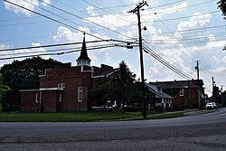
Looking west on KY 36 in New Liberty |
|

Location of New Liberty in the Commonwealth of Kentucky |
|
| Coordinates: | |
| Country | United States |
| State | Kentucky |
| County | Owen |
| Elevation | 889 ft (271 m) |
| Time zone | UTC-5 (EST) |
| • Summer (DST) | UTC-4 (EDT) |
| ZIP code |
40355 |
| Area code | 502 |
| GNIS feature ID | 499364 |
| [1] | |
New Liberty is an unincorporated community in northern Owen County, Kentucky, United States. Kentucky Routes 36 and 227 run through the community. Despite being unincorporated, it has a post office with a ZIP Code of 40355.[2]
The Jacob Hunter House is listed on the National Register of Historic Places. Much of the downtown area is also listed as the New Liberty Historic District.
New Liberty was platted in 1815.[3] A former variant name was “Twin Meeting House”, after a church located in the community.[3] A post office called New Liberty has been in operation since 1823.[4]
References[edit]
- ^
“Geographic Names Information System Feature”. United States Geological Survey. September 20, 1979. Retrieved July 8, 2013.
- ^ “USPS.com – ZIP Code Lookup”. United States Postal Service. Retrieved March 14, 2015.
- ^ a b Rennick, Robert M. (28 August 2013). Kentucky Place Names. University Press of Kentucky. p. 377. ISBN 0-8131-4401-9.
- ^ “Post Offices”. Jim Forte Postal History. Retrieved 13 November 2017.
External links[edit]
Coordinates: 38°36′57″N 84°54′24″W / 38.61583°N 84.90667°W
| Cities |
 |
|
|---|---|---|
| Unincorporated communities |
||
| Ghost town | ||
| Footnotes |
‡This populated place also has portions in an adjacent county or counties |
|
Recent Comments