Guigang – Wikipedia
From Wikipedia, the free encyclopedia
Prefecture-level city in Guangxi, People’s Republic of China
|
Guigang 贵港市 • Gveigangj Si Kweikang |
|
|---|---|
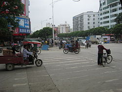
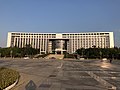
Guigang in 2013. Jiefang Road (解放路) |
|
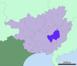
Location of Guigang City jurisdiction in Guangxi |
|

Location in China |
|
| Coordinates (Guigang municipal government): 23°06′43″N 109°35′56″E / 23.112°N 109.599°ECoordinates: 23°06′43″N 109°35′56″E / 23.112°N 109.599°E | |
| Country | People’s Republic of China |
| Autonomous region | Guangxi |
| Municipal seat | Gangbei District |
| • Prefecture-level city | 10,601 km2 (4,093 sq mi) |
| • Urban | 3,546 km2 (1,369 sq mi) |
| • Metro | 2,196 km2 (848 sq mi) |
| Elevation | 45 m (147 ft) |
| • Prefecture-level city | 4,316,262 |
| • Density | 410/km2 (1,100/sq mi) |
| • Urban | 1,700,978 |
| • Urban density | 480/km2 (1,200/sq mi) |
| • Metro | 1,277,231 |
| • Metro density | 580/km2 (1,500/sq mi) |
| Time zone | UTC+8 (China Standard) |
| Postal code |
537100 |
| Area code | 0775 |
| ISO 3166 code | CN-GX-08 |
| Licence plate prefixes | 桂R |
| Website | www |
Guigang (simplified Chinese: 贵港; traditional Chinese: 貴港; pinyin: Guìgǎng; lit. ‘Distinguished Harbour’; Zhuang: Gveigangj) is a prefecture-level city in eastern Guangxi in the People’s Republic of China. Prior to 1988, it was known as Gui County or Guixian (simplified Chinese: 贵县; traditional Chinese: 貴縣; pinyin: Guìxiàn).
Geography and climate[edit]
Guigang is located in eastern Guangxi. It is located between Guangxi’s five major cities: Nanning, Guilin, Liuzhou, Beihai, and Wuzhou. Its location makes it a major transportation and business hub, connecting central China with the south, especially Hong Kong and Macau. Guigang has a rail line, several major highways, an expressway, and most importantly a large port on the Xi River, its direct connection to the Pearl River Delta. The area is 10,601 km2 (4,093 sq mi).
Climate is sub-tropical and monsoonal with an annual mean temperature of 21 °C (70 °F). Annual precipitation is 1,450.6 mm (57.11 in).
| Climate data for Guigang (1981−2010) | |||||||||||||
|---|---|---|---|---|---|---|---|---|---|---|---|---|---|
| Month | Jan | Feb | Mar | Apr | May | Jun | Jul | Aug | Sep | Oct | Nov | Dec | Year |
| Average high °C (°F) | 16.8 (62.2) |
17.8 (64.0) |
20.8 (69.4) |
26.2 (79.2) |
30.1 (86.2) |
32.1 (89.8) |
33.3 (91.9) |
33.5 (92.3) |
32.1 (89.8) |
29.1 (84.4) |
24.5 (76.1) |
19.8 (67.6) |
26.3 (79.4) |
| Average low °C (°F) | 9.4 (48.9) |
11.3 (52.3) |
14.3 (57.7) |
19.2 (66.6) |
22.5 (72.5) |
24.7 (76.5) |
25.3 (77.5) |
25.4 (77.7) |
23.7 (74.7) |
20.0 (68.0) |
15.1 (59.2) |
10.6 (51.1) |
18.5 (65.2) |
| Average precipitation mm (inches) | 48.8 (1.92) |
57.8 (2.28) |
74.5 (2.93) |
123.3 (4.85) |
232.8 (9.17) |
248.4 (9.78) |
252.0 (9.92) |
189.5 (7.46) |
101.7 (4.00) |
47.7 (1.88) |
43.8 (1.72) |
30.3 (1.19) |
1,450.6 (57.1) |
| Source: National Meteorological Center of CMA[2] | |||||||||||||
Administration[edit]
Guigang has 1 county-level city, 3 urban districts, and 1 counties.
Districts:
County-level city:
County:
Demographics[edit]
As of the 2020 Chinese census, its population was 4,316,262 inhabitants whom 1,277,231 lived in the built-up (or metro) area made of Gangbei and Gangnan Districts, Qintang District not being conurbated yet.
Guigang’s population is mainly Cantonese Chinese along with a number of minority tribes.
Economy[edit]
The 2015 GDP was 86.5 billion yuan; nominal GDP per capita was roughly $2,400, making it a relatively poor county in southern China. Transportation, shipping, and logistics are a vital part of Guigang’s economy. More than 100 million tons of goods pass through its ports in one year.[3] Major industries include chemical manufacturing, pharmaceuticals, metallurgy, tannery, textiles, printing, and food stuffs. Agriculture is also important with major crops including cereals such as rice and corn, sugar, medicinal herbs, tobacco, tea, lotus root, and green vegetables.
The Guigang Sports Centre Stadium is located in Guigang. It has a capacity of 30,000 and it is used mostly for football matches. The venue opened on 21 June 2016.[4]
Twin towns and sister cities[edit]
 Nakhon Si Thammarat, Thailand (2016)
References[edit]
External links[edit]
|
Links to related articles |
|||||||||||||||||||||||||||||||||||||||||||||||||||||||||||||||||||||||||||
|---|---|---|---|---|---|---|---|---|---|---|---|---|---|---|---|---|---|---|---|---|---|---|---|---|---|---|---|---|---|---|---|---|---|---|---|---|---|---|---|---|---|---|---|---|---|---|---|---|---|---|---|---|---|---|---|---|---|---|---|---|---|---|---|---|---|---|---|---|---|---|---|---|---|---|---|
|
|||||||||||||||||||||||||||||||||||||||||||||||||||||||||||||||||||||||||||

Recent Comments