Name
LocationGrid Ref. [note 1]
Date Listed
Function
Notes
Reference Number
Image
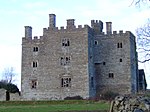
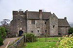
Pencoed Castle
Langstone51°36′01″N 2°51′31″W / 51.600331770635°N 2.8586421009703°W / 51.600331770635; -2.8586421009703 (Pencoed Castle )
3 March 1952 Located at the end of a narrow lane from by-road off B4245, approx 1km S of Llandevaud village and 1km E of Llanmartin.
2904
See more images
Plas Machen
Graig51°34′53″N 3°06′21″W / 51.581518554246°N 3.1059327789217°W / 51.581518554246; -3.1059327789217 (Plas Machen )
3 March 1952 At the end of a track S off the A468, some 900m Se of the church at Lower Machen.
2905
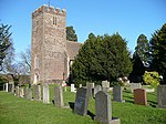
Church of Saint Basil
Graig51°34′42″N 3°02′39″W / 51.578352315159°N 3.0442623351824°W / 51.578352315159; -3.0442623351824 (Church of Saint Basil )
3 January 1963 On the E side of Bassaleg, on the N side of the churchyard some 75m W of the Ebbw River.
2913
See more images
Kemeys Manor
Langstone51°37′44″N 2°53′39″W / 51.628802947214°N 2.8942143658998°W / 51.628802947214; -2.8942143658998 (Kemeys Manor )
3 January 1963 Set on the E side of the A449. Located on the W slope of the steep escarpment of Kemeys Graig, immediately to the S of the A449. Set at the end of a long private drive overlooking the River Usk on a lane leading from Llantrisant to Langstone.
2916
Church of St Mary
Llanwern51°35′10″N 2°54′35″W / 51.58613502185°N 2.9098162987216°W / 51.58613502185; -2.9098162987216 (Church of St Mary )
3 January 1963 Located on the S side of the Lane leading from Llanwern village to Bishton at the junction of the driveway to Barn Farm. Immediately to the N of the Spencer steelworks
2926
See more images
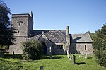
Church of Saint Michael
Graig51°35′11″N 3°06′56″W / 51.586299639907°N 3.1156908304611°W / 51.586299639907; -3.1156908304611 (Church of Saint Michael )
3 January 1963 In a prominent position in the centre of Lower Machen Conservation Area.
2927
See more images
Church of St Mary
Marshfield51°32′14″N 3°03′57″W / 51.537235968344°N 3.0659433771414°W / 51.537235968344; -3.0659433771414 (Church of St Mary )
3 January 1963 Set on the N side of Church Lane opposite Church Farm, leading off Marshfield Road. The church is surrounded by a low rubble wall with cock and hen coping; lych gate to W and remains of medieval cross base to S, now with modern timber cross.[3] [4]
2932
See more images
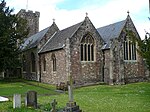
Church of St Michael
Michaelston-y-Fedw51°33′19″N 3°05′48″W / 51.555161039255°N 3.0966531630906°W / 51.555161039255; -3.0966531630906 (Church of St Michael )
3 January 1963 Located at the W side of the village, within a C19 walled enclosure, set behind the public house.
2935
See more images
Church of St Bridget
Wentlooge51°32′07″N 3°01′18″W / 51.535157730088°N 3.0216322261453°W / 51.535157730088; -3.0216322261453 (Church of St Bridget )
3 January 1963 Located on the W side of Church Road, opposite Church Farm, set down a small track.
2941
See more images
Church of St Mary
Whitson51°32′47″N 2°53′40″W / 51.546456421724°N 2.8944445807514°W / 51.546456421724; -2.8944445807514 (Church of St Mary )
3 January 1963 In churchyard reached by drive approximately 300m E of junction with Whitson Common Road. Now redundant.
2943
See more images
Whitson Court
Whitson51°33′28″N 2°54′31″W / 51.557767739818°N 2.9084998959508°W / 51.557767739818; -2.9084998959508 (Whitson Court )
3 January 1963 Set back on E side of road 800m S of electricity substation.
2944
Church of St Cadoc
Caerleon51°36′39″N 2°57′19″W / 51.610742164473°N 2.9554094456283°W / 51.610742164473; -2.9554094456283 (Church of St Cadoc )
7 November 1951 In the centre of Caerleon village immediately north of the National Roman Legion Museum.[5] [6]
2948
See more images
The Endowed School
Caerleon51°36′37″N 2°57′22″W / 51.610205636049°N 2.956149134804°W / 51.610205636049; -2.956149134804 (The Endowed School )
7 November 1951 About 80m south west of the Church of St Cadoc in the centre of Caerleon.
2984
Tower to the south west of, and attached to, The Hanbury Arms
Caerleon51°36′30″N 2°57′08″W / 51.608341381973°N 2.952095397411°W / 51.608341381973; -2.952095397411 (Tower to the south west of, and attached to, The Hanbury Arms )
7 January 1951 Attached to the south west corner of The Hanbury Arms.
2996
Newport Castle
Stow Hill51°35′26″N 2°59′42″W / 51.590693845408°N 2.9950754823605°W / 51.590693845408; -2.9950754823605 (Newport Castle )
26 July 1951 Beside River Usk in angle formed by Newport Bridge and Old Green Interchange.
2997
See more images
Penhow Castle
Penhow51°36′49″N 2°50′01″W / 51.613692958872°N 2.8337354908576°W / 51.613692958872; -2.8337354908576 (Penhow Castle )
3 January 1963 Set high on a hilltop above the Newport to Chepstow road. In its own grounds beyond the Parish Church and reached by drive with relocated stone gatepiers and distinctive ball finials.
3078
See more images
Machen House including attached outbuildings and curved screen wall
Graig51°35′11″N 3°07′00″W / 51.586254205391°N 3.1166856654332°W / 51.586254205391; -3.1166856654332 (Machen House including attached outbuildings and curved screen wall )
10 April 1990 In the centre of the village immediately to W of the Parish Church. Set in its own landscaped grounds and reached by short drive with gate piers.
3084
Gatehouse at Pencoed Castle
Langstone51°36′03″N 2°51′32″W / 51.600823488689°N 2.8590267761234°W / 51.600823488689; -2.8590267761234 (Gatehouse at Pencoed Castle )
19 December 1995 Located at the front of the castle which is at the end of a narrow lane from by-road off the B4245, approx 1km S of Llandevaud village and 1km E of Llanmartin.
17076
Edney Gates at Tredegar House
Coedkernew51°33′43″N 3°01′44″W / 51.561953434212°N 3.0287822730051°W / 51.561953434212; -3.0287822730051 (Edney Gates at Tredegar House )
3 January 1963 Middle Court is located immediately to the northwest of Tredegar House separating it from the Stable Court, the Edney Gates and screen are set at the north end dividing the house and Stable Court.
17097
Boundary walls to Orangery and Cedar gardens at Tredegar House
Coedkernew51°33′41″N 3°01′48″W / 51.561251336739°N 3.0298916545766°W / 51.561251336739; -3.0298916545766 (Boundary walls to Orangery and Cedar gardens at Tredegar House )
3 January 1963 Set immediately to the west of Tredegar House and the Orangery, enclosing the Cedar Garden and the Orangery Garden. Set of brick piers set at the north end of the Orangery Garden, the south of the Cedar Garden and a central pair linking the two garden courtyard
17098
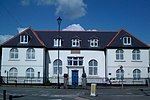
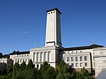
Newport Civic Centre
Allt yr yn51°35′19″N 3°00′20″W / 51.588582004321°N 3.0054800129745°W / 51.588582004321; -3.0054800129745 (Newport Civic Centre )
14 September 1999 Occupies a large prominent site S of Fields Road, bounded by Godfrey Road (E), Faulkner Road (S), and Clytha Park Road to the W.
22333
See more images
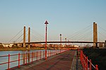
George Street Bridge
Victoria, Newport51°35′04″N 2°59′03″W / 51.584357812822°N 2.9840543235514°W / 51.584357812822; -2.9840543235514 (George Street Bridge )
31 October 2001 Spans River Usk between Corporation Road and Dock Street.
25847
See more images
Railway viaduct over Ebbw River
Rogerstone51°34′45″N 3°02′35″W / 51.579073553991°N 3.0430377463023°W / 51.579073553991; -3.0430377463023 (Railway viaduct over Ebbw River )
23 July 2003 Crossing the Ebbw River from E to W on the NE side of Bassaleg.
81343


Recent Comments