Administrative divisions of Khmelnytskyi Oblast
From Wikipedia, the free encyclopedia
Place
|
Khmelnytskyi Oblast Хмельницька область |
|
|---|---|

Flag 
Coat of arms |
|
 |
|
| Administrative center | Khmelnytskyi |
| Administrative divisions |
|
| Statistics dated 1 January 2006[1][2] | |
The administrative divisions of Khmelnytskyi Oblast (Ukrainian: Хмельницька область) follows the general scheme of the administrative divisions in Ukraine. It is subdivided into districts (raions) which are subdivided into territorial communities (hromadas). As Ukraine is a unitary state, any changes to the administrative divisions have to be approved by the Verkhovna Rada.
The oblast was established on September 22, 1937, as the “Kamianets-Podilskyi Oblast” to replace the Kamianets Okruha and other neighboring administrative regions in the Ukrainian Soviet Socialist Republic. Its administrative center was moved from Kamianets-Podilskyi to Proskuriv in 1941, and when Proskuriv’s name was changed to Khmelnytskyi, the oblast’s name was changed as well. The administrative divisions in the oblast have remained the same since January 1, 2006.[2]
Khmelnytskyi Oblast is one of the smaller of the 24 oblasts of Ukraine with a total area of 20,629 square kilometres (7,965 sq mi).[1] Its population was 1,426,649 at the 2001 census.[1] The oblast borders upon Rivne Oblast to the northwest, Zhytomyr Oblast to the northeast, Vinnytsia Oblast to the east, Chernivtsi Oblast to the south, and Ternopil Oblast to the west.
The oblast has 24 urban-type settlements, 568 rural municipalities, 1409 villages, and five rural settlements.
Current[edit]

On 18 July 2020, the number of districts was reduced to three.[3][4] These are:
- Kamianets-Podilskyi (Кам’янець-Подільський район), the center is in the town of Kamianets-Podilskyi;
- Khmelnytskyi (Хмельницький район), the center is in the city of Khmelnytskyi;
- Shepetivka (Шепетівський район), the center is in the town of Shepetivka.
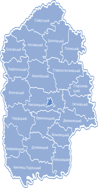
Administrative divisions before 2020[edit]
Before July 2020, the Khmelnytskyi Oblast was administratively divided into 20 districts (райони).[5] which served as the second level of administrative division in the country. It had a total of 13 cities, six of which are under the oblast’s jurisdiction (including its administrative center Khmelnytskyi) and seven which are under their raion’s jurisdiction.
| District | Area (km2) | Population (2012) | Administrative center | Urban-type settlements | Rural municipalities | Villages | Settlements |
|---|---|---|---|---|---|---|---|
| 776.3 | 28,128 | Bilohiria | Bilohiria Yampil |
23 | 72 | — | |
| 930 | 42,722 | Chemerivtsi | Chemerivtsi Zakupne |
33 | 68 | — | |
| 910 | 32,955 | Derazhnia | Lozove Vovkovyntsi |
22 | 59 | — | |
| 1,180 | 64,422 | Dunaivtsi | Dunaivtsi Smotrych |
43 | 83 | — | |
| 1,110 | 49,939 | Horodok | Sataniv | 29 | 71 | 1 | |
| 1,250 | 46,059 | Iziaslav | — | 29 | 91 | — | |
| 1,537 | 67,900 | Kamianets-Podilskyi | Stara Ushytsia | 42 | 120 | 1 | |
| 1,220 | 52,906 | Khmelnytskyi | Chornyi Ostriv | 38 | 76 | 1 | |
| 1,180 | 53,814 | Krasyliv | Antoniny | 35 | 93 | — | |
| 951 | 29,209 | Letychiv | Letychiv Medzhybizh |
19 | 55 | — | |
| 853 | 30,271 | Nova Ushytsia | Nova Ushytsia | 21 | 57 | 1 | |
| 866 | 45,813 | Polonne | Poninka | 17 | 44 | 1 | |
| 1,160 | 34,724 | Shepetivka | Hrytsiv | 22 | 68 | — | |
| 1,162 | 30,743 | Slavuta | — | 36 | 79 | — | |
| 1,210 | 30,448 | Starokostiantyniv | — | 30 | 97 | — | |
| 662 | 21,276 | Stara Syniava | Stara Syniava | 15 | 44 | — | |
| 716 | 27,831 | Teofipol | Teofipol Bazaliia |
22 | 53 | — | |
| 653 | 25,630 | Vinkivtsi | Vinkivtsi | 17 | 35 | — | |
| 1,103 | 53,113 | Volochysk | Narkevychi Viitivtsi |
40 | 85 | — | |
| 898 | 31,599 | Yarmolyntsi | Yarmolyntsi | 29 | 59 | — |
Populated settlements[edit]
Cities[edit]
Khmelnytskyi Oblast has a total of 13 cities, with six of them governed under the oblast’s jurisdiction (міста обласного значення),[6] and the remaining seven under their respective district’s jurisdiction (міста районного значення).[7] Each urban locality also administers their own respective municipality, which can have a few villages and settlements under its jurisdiction. The combined urban population of the cities and urban-type settlements was 723,431 in 2001.[1]
Urban-type settlements[edit]
Khmelnytskyi Oblast has a total of 24 urban-type settlements (селищ міського типу).[8] Each urban locality also administers their own respective municipality, which can have a few villages and settlements under its jurisdiction.
Villages[edit]
Khmelnytskyi Oblast has a total of 1,409 villages (сіл)[9] and five settlements (селищ).[10] Out of the 1,409 villages, 568 villages administer their own rural municipality (сільських рад) which may have a few other villages under its jurisdiction.[11] The combined rural population of the villages and settlements was 703,218 in 2001.[1]
See also[edit]
References[edit]
External links[edit]
Recent Comments