Name
LocationGrid Ref. [note 1]
Date Listed
Function
Notes
Reference Number
Image
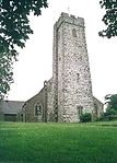
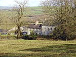
Dovecote
Angle51°41′09″N 5°05′19″W / 51.685729086453°N 5.0885018117454°W / 51.685729086453; -5.0885018117454 (Dovecote )
14 May 1970 Dovecote
In field immediately N of Castle Farm.[3] [4]
5922
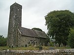
St. Michael and All Angel’s Church
Bosherston, Stackpole51°36′55″N 4°56′21″W / 51.615385933141°N 4.9391747248022°W / 51.615385933141; -4.9391747248022 (St. Michael and All Angel’s Church )
14 May 1970 Church
At the north end of Bosherston village.[5] [6]
5927
Church of Saint David
Caldey Island, Tenby51°38′16″N 4°41′07″W / 51.637815693691°N 4.6852118879914°W / 51.637815693691; -4.6852118879914 (Church of Saint David )
14 May 1970 Church
Situated some 50m W of Caldey Abbey chapel.[7] [8]
5933
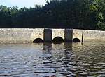
Carew Bridge
Carew51°41′57″N 4°49′36″W / 51.699112992037°N 4.8266410667377°W / 51.699112992037; -4.8266410667377 (Carew Bridge )
14 May 1970 Bridge
About 500 m E of Carew Castle carrying the Carew to Cresselly A4075 road across the estuary of the Carew River.[9] [10]
5939
See more images
The Fortified Rectory
Carew51°41′21″N 4°49′50″W / 51.689180781489°N 4.8304931768052°W / 51.689180781489; -4.8304931768052 (The Fortified Rectory )
14 May 1972 Rectory
100 m SW of St Mary’s churchyard.[11] [12]
5947
The Old Vicarage (remains)
Castlemartin51°38′59″N 5°01′16″W / 51.649831581935°N 5.0210974921216°W / 51.649831581935; -5.0210974921216 (The Old Vicarage (remains) )
14 May 1970 Vicarage (ruin)
Within St Michael’s churchyard, about 40 m E of the church.[13] [14]
5949
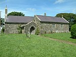
Church of St Lawrence
Gumfreston, St Florence51°40′36″N 4°44′10″W / 51.676757628649°N 4.7360784284226°W / 51.676757628649; -4.7360784284226 (Church of St Lawrence )
5 April 1970 Church
150 m S of the B4318 in Gumfreston.[15] [16]
5958
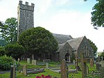
Hodgeston Parish Church
Hodgeston, Lamphey51°39′31″N 4°51′01″W / 51.658524509624°N 4.8503587441771°W / 51.658524509624; -4.8503587441771 (Hodgeston Parish Church )
14 May 1970 Church
In village of Hodgeston, E of Lamphey[17] [18]
5959
See more images
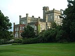
Lamphey Court
Lamphey51°40′25″N 4°52′09″W / 51.673588303338°N 4.8691553556265°W / 51.673588303338; -4.8691553556265 (Lamphey Court )
14 May 1970 Hotel
To the N of Lamphey Village.[19] [20]
5968
Church of St Caradoc
Lawrenny, Martletwy51°43′32″N 4°52′24″W / 51.725540747131°N 4.8733727628831°W / 51.725540747131; -4.8733727628831 (Church of St Caradoc )
14 May 1970 Church
At the W of Lawrenny village, at the entrance to the grounds of the former Lawrenny Castle.[21] [22]
5971
See more images
Dovecote
Manorbier51°38′46″N 4°48′06″W / 51.646005780035°N 4.8015629324996°W / 51.646005780035; -4.8015629324996 (Dovecote )
14 May 1970 Dovecote
5977
Sunny Hill Farmhouse
Manorbier51°39′54″N 4°48′12″W / 51.66502040927°N 4.8033584582147°W / 51.66502040927; -4.8033584582147 (Sunny Hill Farmhouse )
14 May 1970 Farmhouse
300 m S of the Ridgeway, 500 m W of turning to St Florence.[23] [24]
5984
Norchard
Manorbier51°39′40″N 4°46′29″W / 51.661124338356°N 4.7747594068906°W / 51.661124338356; -4.7747594068906 (Norchard )
14 May 1970 House
800 m S of the Ridgeway and 1 km E of Manobier Station.[25] [26]
5986
Church of St Nicholas
Penally51°39′35″N 4°43′22″W / 51.659754603227°N 4.7228053364522°W / 51.659754603227; -4.7228053364522 (Church of St Nicholas )
14 May 1970 Church
In the centre of the village of Penally. The churchyard is enclosed within a rubble masonry wall with simple iron gates.[27] [28]
5992
Carswell Medieval House
Penally51°40′34″N 4°45′08″W / 51.675982100032°N 4.7522767609135°W / 51.675982100032; -4.7522767609135 (Carswell Medieval House )
14 May 1970 House (ruin)
50 m N of Carswell Farm House, in the farmyard. It is the western of the two ruined buildings.[29] [30]
6005
Church of St Florence
St Florence51°40′35″N 4°46′30″W / 51.67635324112°N 4.7750253404422°W / 51.67635324112; -4.7750253404422 (Church of St Florence )
14 May 1970 Church
Centrally placed in a compact village.[31] [32]
6008
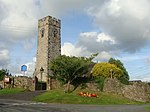
St. Twynnell’s Church
Stackpole51°38′23″N 4°57′53″W / 51.639619036118°N 4.9646942398162°W / 51.639619036118; -4.9646942398162 (St. Twynnell’s Church )
14 May 1970 Church
Mediaeval church restored by Lord Cawdor in 1858.[33] [34]
6018
Park House
Stackpole51°37′41″N 4°55′06″W / 51.627957199475°N 4.9184412628832°W / 51.627957199475; -4.9184412628832 (Park House )
14 May 1970 House
House of c.1700 with mid-18th century alterations.[35] [36]
6021
St. Mary’s Church
Castlemartin51°38′18″N 4°59′22″W / 51.638204773636°N 4.989506982954°W / 51.638204773636; -4.989506982954 (St. Mary’s Church )
14 May 1970 Church
2 km E of Castlemartin.[37] [38]
6035
Carew Tidal Mill and Tidal Barrier
Carew51°41′56″N 4°50′07″W / 51.69893705967°N 4.8354009750078°W / 51.69893705967; -4.8354009750078 (Carew Tidal Mill and Tidal Barrier )
29 September 1971 Mill/Tidal barrier
The Tidal Barrier lies across the estuary of the Carew River about 300 m W of Carew Castle. The tidal mill stands on it near to the left (S) bank, over the deeper water where the natural river channel lies.[39] [40]
6038
See more images
St Elidyr’s Church
Amroth51°44′23″N 4°39′42″W / 51.739589505939°N 4.6617951788039°W / 51.739589505939; -4.6617951788039 (St Elidyr’s Church )
21 June 1971 Church
1 km N of Amroth Village, in an isolated group with Amroth Farm and the old village school. The group is called ‘Castle Back’. The church is in a roundish graveyard surrounded by walls and hedges.[41] [42]
6044
Church of St. Mary
Kilgetty-Begelly51°43′58″N 4°43′36″W / 51.732820076623°N 4.7265744391592°W / 51.732820076623; -4.7265744391592 (Church of St. Mary )
21 June 1971 Church
In village of Begelly, 0.5 km N of the A477(T). The church is in a large churchyard with low stone wall, stile and lychgate to N.[43] [44]
6045
Church of Saint Mary
Bletherston, New Moat51°51′21″N 4°48′12″W / 51.855969636007°N 4.803454994333°W / 51.855969636007; -4.803454994333 (Church of Saint Mary )
21 June 1971 Church
In a prominent position in the centre of Bletherston village.[45] [46]
6046
Church of St. Elidyr
Lampeter Velfrey51°45′57″N 4°41′43″W / 51.765941158729°N 4.6951756859274°W / 51.765941158729; -4.6951756859274 (Church of St. Elidyr )
21 June 1971 Church
4 km S of village of Lampeter Velfrey, about 400 m N of Ludchurch village, in a square churchyard partly walled.[47] [48]
6050
Church of St Jeffrey and St Oswald
Jeffreyston51°43′29″N 4°46′03″W / 51.724788412767°N 4.7676090819266°W / 51.724788412767; -4.7676090819266 (Church of St Jeffrey and St Oswald )
21 June 1971 Church
In the centre of the village of Jeffreyston. The churchyard is circular with late C19 extensions N and E. There is a preaching cross (separately listed) to the S side and a small free-standing mortuary chapel to the N side.[49] [50]
6052
Church of St Aidan
Llawhaden51°49′21″N 4°47′40″W / 51.822570078996°N 4.7943262931519°W / 51.822570078996; -4.7943262931519 (Church of St Aidan )
21 June 1971 Church
In a square churchyard on the right bank of the Eastern Cleddau, 300 m N of Llawhaden Bridge.[51] [52]
6062
Llawhaden Bridge and River Bank Wall
Llawhaden51°49′14″N 4°47′42″W / 51.820605125709°N 4.7948867054676°W / 51.820605125709; -4.7948867054676 (Llawhaden Bridge and River Bank Wall )
21 June 1971 Bridge
On Eastern Cleddau ? km E of Llawhaden Village[53] [54]
6064
Vaynor
Llawhaden51°49′26″N 4°45′40″W / 51.823759234778°N 4.7612370916763°W / 51.823759234778; -4.7612370916763 (Vaynor )
21 June 1971 House
Reached by a private drive on the E side of the B4313 Pont Sh?n to Bethesda road[55]
6072
Church of St Leonard
Loveston, Jeffreyston51°44′32″N 4°46′35″W / 51.742134520881°N 4.7764492366699°W / 51.742134520881; -4.7764492366699 (Church of St Leonard )
21 June 1971 Church
Loveston[56] [57]
6076
Parish Church of Saint Nicholas
New Moat51°53′31″N 4°49′02″W / 51.891928865935°N 4.8171914507809°W / 51.891928865935; -4.8171914507809 (Parish Church of Saint Nicholas )
21 June 1971 Church
Prominently situated on S side of village on W side of road; raised rounded graveyard.[58] [59]
6086
Blackpool Bridge
Martletwy51°47′44″N 4°48′52″W / 51.795519686944°N 4.8145250454696°W / 51.795519686944; -4.8145250454696 (Blackpool Bridge )
21 June 1971 Bridge
Crossing the Eastern Cleddau adjacent to Blackpool Mill, closest to the highest navigable point of the river. Also in Slebech[60] [61]
6089
See more images
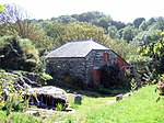
Blackpool Mill
Martletwy51°47′43″N 4°48′53″W / 51.795290660154°N 4.81469933008°W / 51.795290660154; -4.81469933008 (Blackpool Mill )
21 June 1971 Mill
On the left bank of the Eastern Cleddau 1 km SW of Canaston Bridge.[62] [63]
6090
See more images
St Issell’s Church
Saundersfoot51°43′12″N 4°42′18″W / 51.71989382254°N 4.7049743782643°W / 51.71989382254; -4.7049743782643 (St Issell’s Church )
21 June 1971 1km N of the village of Saundersfoot. The church stands in a large undulating graveyard through which a stream passes.[64]
6093
Slebech Park
Slebech51°47′23″N 4°51′21″W / 51.789691021696°N 4.8557985879011°W / 51.789691021696; -4.8557985879011 (Slebech Park )
21 June 1971 Country house
In extensive grounds 2 km E of Picton Castle, overlooking the Eastern Cleddau.[65]
6102
Tenby Castle remains
Tenby51°40′20″N 4°41′44″W / 51.672294836059°N 4.6954676719624°W / 51.672294836059; -4.6954676719624 (Tenby Castle remains )
19 March 1951 Castle ruin
Remains are situated at various locations on Castle Hill, on the NE side of the town.[66] [67]
6111
See more images
Laston House
Tenby51°40′22″N 4°41′47″W / 51.672715617758°N 4.6963316175195°W / 51.672715617758; -4.6963316175195 (Laston House )
19 March 1951 House
Situated on the N side of Castle Square facing S to St Julian’s Street.[68]
6119
The Prize House
Tenby51°40′23″N 4°42′04″W / 51.672917716332°N 4.7012182318833°W / 51.672917716332; -4.7012182318833 (The Prize House )
31 May 1954 House
Facing the sea next to the Royal Lion Hotel just S of the junction of the High Street and White Lion Street.[69]
6165
Medieval structure in the churchyard
Tenby51°40′18″N 4°42′00″W / 51.671791458499°N 4.700138679336°W / 51.671791458499; -4.700138679336 (Medieval structure in the churchyard )
19 March 1951 Situated some 20m W of the Church of Saint Mary in Liberty.[70]
6175
Norton House, including garden wall to street
Tenby51°40′32″N 4°42′13″W / 51.675513790048°N 4.7036872841811°W / 51.675513790048; -4.7036872841811 (Norton House, including garden wall to street )
19 March 1951 House
Situated on the W side of The Norton some 110m N of the junction with St John’s Hill.[71]
6211
The Former Assembly Rooms
Tenby51°40′22″N 4°41′48″W / 51.672809752045°N 4.6965397167614°W / 51.672809752045; -4.6965397167614 (The Former Assembly Rooms )
19 March 1951 Situated in a prominent position between the harbour and the sea at the N end of Pier Hill.[72]
6223
Plantagenet House
Tenby51°40′18″N 4°41′53″W / 51.671621212663°N 4.6981614051553°W / 51.671621212663; -4.6981614051553 (Plantagenet House )
19 March 1951 Situated on the W side of Quay Hill between Tudor Square and Bridge Street.[73]
6227
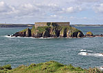
Saint Catherine’s Fort
Tenby51°40′14″N 4°41′31″W / 51.67063159829°N 4.6919264492501°W / 51.67063159829; -4.6919264492501 (Saint Catherine’s Fort )
19 March 1951 Situated in a prominent position on Saint Catherine’s Island to the E of the town and SE of Castle Hill.[74] [75]
6229
See more images
No 3 Rock Terrace including railings
Tenby51°40′15″N 4°41′49″W / 51.670856169411°N 4.6970166468965°W / 51.670856169411; -4.6970166468965 (No 3 Rock Terrace including railings )
19 March 1951 Houses
Set back from the street line on the S side of St Julian’s Street opposite Slate House with rear facade overlooking Iron Bar Sands.[76]
6261
No 1 Lexden Terrace, including area railings
Tenby51°40′16″N 4°41′47″W / 51.671205113285°N 4.6963141796966°W / 51.671205113285; -4.6963141796966 (No 1 Lexden Terrace, including area railings )
19 March 1951 Houses
Lexden Terrace lies at a tangent to the E side of St Julian’s Street, the rear overlooking Castle Sands, all set back behind a forecourt wall.[77]
6268
Dovecote in field to NW of Priory Farmhouse
Pembroke51°40′41″N 4°55′41″W / 51.677972081061°N 4.9281682787577°W / 51.677972081061; -4.9281682787577 (Dovecote in field to NW of Priory Farmhouse )
14 July 1981 Dovecote
Situated near the centre of a field some 350m NW of Priory Farmhouse.[78]
6327
Priory Farmhouse
Pembroke51°40′32″N 4°55′29″W / 51.675575426862°N 4.9247442047819°W / 51.675575426862; -4.9247442047819 (Priory Farmhouse )
10 February 1951 Situated in Monkton approximately 50m W of the Priory Church of Saint Nicholas.[79]
6328
Pembroke town walls
Pembroke51°40′25″N 4°54′42″W / 51.673704385873°N 4.9117781194389°W / 51.673704385873; -4.9117781194389 (Pembroke town walls )
9 June 1976 Wall
On the S side of the town extending some 225m E from no. 5 Common Road to Rock Terrace.[80]
6342
Outbuilding range at Kingston Farm to SE of old farmhouse
Pembroke51°39′29″N 4°54′03″W / 51.658094356686°N 4.9007843989951°W / 51.658094356686; -4.9007843989951 (Outbuilding range at Kingston Farm to SE of old farmhouse )
14 July 1981 Situated SE of the house at Kingston Farm some 2km SE of the centre of Pembroke.[81]
6363
Nos 89/91 Main Street
Pembroke51°40′29″N 4°54′47″W / 51.674740226648°N 4.9131610040898°W / 51.674740226648; -4.9131610040898 (Nos 89/91 Main Street )
10 February 1951 On the S side of Main Street some 35m E of its W junction with East Back.[82]
6385
111 Main Street
Pembroke51°40′28″N 4°54′40″W / 51.674405162175°N 4.91108534251°W / 51.674405162175; -4.91108534251 (111 Main Street )
14 July 1981 House
On the S side of Main Street near its E junction with East Back and opposite the entrance to the Church of Saint Michael.[83]
6395
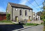
Zion Free Church, Meyrick Street
Pembroke Dock51°41′34″N 4°56′36″W / 51.692711760614°N 4.943273567296°W / 51.692711760614; -4.943273567296 (Zion Free Church, Meyrick Street )
14 July 1981 Church
Built 1846-8, extended 1866-7 and renovated 1882, 1911 and 1986.[84] Formerly listed as Wesleyan Methodist Chapel
6415
Former Guard House, the Dockyard
Pembroke Dock51°41′39″N 4°57′09″W / 51.694284295682°N 4.952608975907°W / 51.694284295682; -4.952608975907 (Former Guard House, the Dockyard )
18 January 1974 6436
The Old Storehouse, the Dockyard
Pembroke Dock51°41′43″N 4°57′10″W / 51.695232075417°N 4.9528299082564°W / 51.695232075417; -4.9528299082564 (The Old Storehouse, the Dockyard )
18 January 1974 Situated to W of Sunderland House, behind ferry terminal.[85] formerly listed as Main Stores of R Hayes Investments Ltd
6441
The Defensible Barracks Presely View (W End)
Pembroke Dock51°41′22″N 4°57′07″W / 51.689330116781°N 4.9518377478342°W / 51.689330116781; -4.9518377478342 (The Defensible Barracks Presely View (W End) )
18 January 1974 Barracks
6448
No 1, The Terrace
Pembroke Dock51°41′36″N 4°57′09″W / 51.693252420968°N 4.9525128244509°W / 51.693252420968; -4.9525128244509 (No 1, The Terrace )
18 January 1974 House
formerly listed together with the Commodore Club[86]
6454
No 2, The Terrace, The Dockyard
Pembroke Dock51°41′35″N 4°57′08″W / 51.693108890757°N 4.9521416787765°W / 51.693108890757; -4.9521416787765 (No 2, The Terrace, The Dockyard )
18 January 1974 House
6455
Garrison Chapel
Pembroke Dock51°41′35″N 4°56′56″W / 51.6930083834°N 4.9489947374375°W / 51.6930083834; -4.9489947374375 (Garrison Chapel )
18 January 1974 Museum
6458
Flemish Cottage
Pembroke51°40′34″N 4°55′13″W / 51.676126918796°N 4.9203096471182°W / 51.676126918796; -4.9203096471182 (Flemish Cottage )
14 July 1981 On the S side of the road opposite Pembroke Castle and some 65m E of Monkton Bridge.[87]
6468
Panteg farmhouse
Llanddewi Velfrey51°48′48″N 4°40′30″W / 51.813242415524°N 4.674928409681°W / 51.813242415524; -4.674928409681 (Panteg farmhouse )
2 April 1986 Farmhouse
On an elevated site to SE of village, overlooking Lampeter Vale. Reached by a long curving track along wooded hillside.[88]
6547
Orielton Field Centre
Orielton, Hundleton51°39′10″N 4°57′30″W / 51.652767352549°N 4.9583377113403°W / 51.652767352549; -4.9583377113403 (Orielton Field Centre )
14 May 1970 Field Centre
Clay Lane, Orielton
6573
Former Banqueting Tower
Orielton, Hundleton51°39′01″N 4°57′30″W / 51.650192733117°N 4.958430203141°W / 51.650192733117; -4.958430203141 (Former Banqueting Tower )
14 May 1970 Tower
about 300m SE OF Orielton Field Centre[89]
6586
Former Church of Saint Mary, Pwllcrochan
Pwllcrochan, Hundleton51°41′02″N 5°00′35″W / 51.684026714553°N 5.0096004206368°W / 51.684026714553; -5.0096004206368 (Former Church of Saint Mary, Pwllcrochan )
14 May 1970 6587
Dovecote and attached Courtyard Ranges of Outbuildings
West Orielton, Hundleton51°39′07″N 4°57′38″W / 51.652036561231°N 4.9605601271701°W / 51.652036561231; -4.9605601271701 (Dovecote and attached Courtyard Ranges of Outbuildings )
29 September 1993 Dovecote
Farm Buildings E of West Orielton[90]
6600
Llechryd Bridge
Manordeifi52°03′44″N 4°36′03″W / 52.062268626237°N 4.6009663352119°W / 52.062268626237; -4.6009663352119 (Llechryd Bridge )
21 September 1964 Bridge
Situated across Afon Teifi between Llechryd and Castell Malgwyn lodge.[91]
9895
Church of St Llawddog
Cilgerran52°03′23″N 4°38′26″W / 52.056413927067°N 4.6404810300321°W / 52.056413927067; -4.6404810300321 (Church of St Llawddog )
16 January 1952 Church
Church Street (S side)
11972
Glandovan
Cilgerran52°02′33″N 4°37′38″W / 52.042594249351°N 4.6271385206755°W / 52.042594249351; -4.6271385206755 (Glandovan )
16 January 1952 House
16th century house.[92] [93]
11973
Benton Castle
Burton51°43′30″N 4°53′22″W / 51.725100718444°N 4.8894197743197°W / 51.725100718444; -4.8894197743197 (Benton Castle )
13 December 1951 Castle
Built on a spectacular position high above the W side of the Daugleddau some 2.3km NE of the church at Burton.[94] [95]
11981
See more images
Rosemarket dovecote
Rosemarket51°44′07″N 4°57′53″W / 51.735396852343°N 4.9646475900588°W / 51.735396852343; -4.9646475900588 (Rosemarket dovecote )
13 December 1951 Dovecote
In the centre of a field known as Pigeon Hay some 100m NE of the crossroads near the Church of Saint Ismael.[96]
11983
Scolton Manor
Scolton, Spittal51°51′38″N 4°55′14″W / 51.860595091642°N 4.9204398641625°W / 51.860595091642; -4.9204398641625 (Scolton Manor )
13 December 1951 Museum
Situated in own grounds on W side of B4329 some 1.5 km SE of Spittal village.[97]
11984
Church of Saint Mary
Burton51°42′48″N 4°55′03″W / 51.71326776774°N 4.9175779664338°W / 51.71326776774; -4.9175779664338 (Church of Saint Mary )
3 January 1963 Church
On the N side of Burton at the end of Church Road.[98]
11987
Church of St Ishmael
Camrose51°50′26″N 5°00′38″W / 51.840580929917°N 5.0104407481316°W / 51.840580929917; -5.0104407481316 (Church of St Ishmael )
3 January 1963 Church
Situated in churchyard in centre of Camrose village.[99]
11988
Camrose House
Camrose51°50′17″N 5°00′38″W / 51.83807034928°N 5.0104909274838°W / 51.83807034928; -5.0104909274838 (Camrose House )
3 January 1963 House
Situated on the S side of the village, the drive to Camrose House and Home Farm off a minor road just S of the bridge over Camrose Brook.[100]
11989
Clareston
Freystrop51°45′20″N 4°57′40″W / 51.755549851009°N 4.961185972529°W / 51.755549851009; -4.961185972529 (Clareston )
3 January 1963 House
At the end of a drive running SW off the road through Freystrop just S of Puddleduck Bridge.[101]
11991
Church of St Peter
Johnston51°45′15″N 4°59′51″W / 51.754033587062°N 4.9974313947395°W / 51.754033587062; -4.9974313947395 (Church of St Peter )
3 January 1963 Church
In centre of village, in churchyard to E of main road.[102]
11996
Nolton Rectory
Nolton and Roch51°49′15″N 5°05′48″W / 51.82090065132°N 5.0967149481249°W / 51.82090065132; -5.0967149481249 (Nolton Rectory )
3 January 1963 Rectory
Situated opposite Nolton church in Nolton village.[103]
12000
Cottesmore including attached E conservatory and NW wing.
Rudbaxton51°49′42″N 4°58′43″W / 51.828243549483°N 4.9786995673515°W / 51.828243549483; -4.9786995673515 (Cottesmore including attached E conservatory and NW wing. )
3 January 1963 House
Reached by a drive of some 650m W off the A40 at Tangiers.[104]
12002
Church of Saint Andrew
Walwyn’s Castle51°44′42″N 5°03′55″W / 51.744960487794°N 5.0654056118178°W / 51.744960487794; -5.0654056118178 (Church of Saint Andrew )
3 January 1963 Church
On the S side of the minor road through Robeston West.[105]
12005
Poyston including attached service ranges to NW.
Rudbaxton51°50′23″N 4°57′06″W / 51.83981739744°N 4.9517471784836°W / 51.83981739744; -4.9517471784836 (Poyston including attached service ranges to NW. )
3 January 1963 House
Situated some 1.3 km E of the A40 and just N of the airfield at Withybush.[106]
12010
Church of St Dogfael
St Dogswells, Wolfscastle51°54′48″N 4°57′16″W / 51.913405977564°N 4.954523851847°W / 51.913405977564; -4.954523851847 (Church of St Dogfael )
3 January 1963 Church
Situated S of the Afon Anghof some 150m E of Sealyham Bridge and some 400m N of St Dogwells Farm.[107]
12011
Church of St Mary
Wiston51°49′30″N 4°52′17″W / 51.825121315394°N 4.8714368949105°W / 51.825121315394; -4.8714368949105 (Church of St Mary )
3 January 1963 Church
In a prominent position on the S side of the road through Wiston and some 200m S of Wiston Castle.[108]
12017
See more images
New Bridge and four lamp standards
Haverfordwest51°48′08″N 4°58′02″W / 51.802319308382°N 4.9671679090592°W / 51.802319308382; -4.9671679090592 (New Bridge and four lamp standards )
7 January 1974 Bridge
Situated between Picton Place and Victoria Place, across the Western Cleddau river.[109]
12020
The Old Bridge
Haverfordwest51°48′14″N 4°58′08″W / 51.803956137662°N 4.9689438331395°W / 51.803956137662; -4.9689438331395 (The Old Bridge )
10 December 1951 Bridge
Situated across river between N end of Bridge Street and Old Bridge.[110]
12021
Church of Saint Martin of Tours
Haverfordwest51°48′09″N 4°58′20″W / 51.802585812763°N 4.9722628934344°W / 51.802585812763; -4.9722628934344 (Church of Saint Martin of Tours )
10 December 1951 Church
Situated in churchyard raised above Church Street and Chapel Lane.[111]
12041
Tabernacle Congregational Church
Haverfordwest51°48′10″N 4°58′24″W / 51.802658104611°N 4.9733121629259°W / 51.802658104611; -4.9733121629259 (Tabernacle Congregational Church )
7 January 1974 Church
Situated on SW corner of City Road/Barn St, facing across main road to St Martin’s Church.[112]
12044
See more images
Tabernacle Church School
Haverfordwest51°48′10″N 4°58′23″W / 51.802814422403°N 4.9731773846173°W / 51.802814422403; -4.9731773846173 (Tabernacle Church School )
7 January 1974 School
Situated adjoining Tabernacle Church to N, overlooking junction of City Road and Perrots Road.[113]
12045
Forecourt dwarf wall and railings to Tabernacle Church and to Tabernacle Church School
Haverfordwest51°48′10″N 4°58′23″W / 51.802665827555°N 4.9730080223596°W / 51.802665827555; -4.9730080223596 (Forecourt dwarf wall and railings to Tabernacle Church and to Tabernacle Church School )
7 January 1974 Situated across the E fronts of the chapel and school, overlooking junction with Perrots Road.[114]
12046
Williamston House including area railings
Haverfordwest51°48′01″N 4°58′12″W / 51.800214076635°N 4.9700323854749°W / 51.800214076635; -4.9700323854749 (Williamston House including area railings )
7 January 1974 House
On the S side of Goat Street some 45m E of its junction with Market Street.[115]
12081
8 Goat Street
Haverfordwest51°48′01″N 4°58′13″W / 51.80039°N 4.97020°W / 51.80039; -4.97020 (8 Goat Street )
10 December 1951 House
Large 18th-century terraced house, attached to the similar Grade II* listed No. 10[116] [117]
12090
Foley House
Haverfordwest51°48′02″N 4°58′11″W / 51.8005985356°N 4.969767542701°W / 51.8005985356; -4.969767542701 (Foley House )
10 December 1951 House
Situated in own grounds on sloping site half way down street, set back in terraced forecourt.[118]
12092
Hermon’s Hill House
Haverfordwest51°48′02″N 4°58′07″W / 51.800513026567°N 4.9685288757473°W / 51.800513026567; -4.9685288757473 (Hermon’s Hill House )
10 December 1951 Situated at top end of Hill Lane to S of No 27 Hill Lane.[119]
12097
15 High Street
Haverfordwest51°48′05″N 4°58′14″W / 51.801250274155°N 4.9706662958888°W / 51.801250274155; -4.9706662958888 (15 High Street )
10 December 1951 Shop
On the S side of the High Street opposite its junction with Dark Street.[120]
12104
The Shire Hall
Haverfordwest51°48′06″N 4°58′07″W / 51.801562452776°N 4.9686413833839°W / 51.801562452776; -4.9686413833839 (The Shire Hall )
10 December 1951 Restaurant
On the S side of the High Street some 25m W of its junction with Quay Street.[121]
12110
Railings, gates, steps and retaining wall to the Shire Hall
Haverfordwest51°48′06″N 4°58′07″W / 51.801687055344°N 4.9686930952517°W / 51.801687055344; -4.9686930952517 (Railings, gates, steps and retaining wall to the Shire Hall )
7 January 1974 Railings/gates/steps
On the S side of the High Street some 25m W of its junction with Quay Street.[122]
12111
12 High Street
Haverfordwest51°48′05″N 4°58′15″W / 51.801524576557°N 4.9708439151064°W / 51.801524576557; -4.9708439151064 (12 High Street )
7 January 1974 Office
Situated attached to No 1 Dark Street, at junction of High Street and Dark Street.[123]
12116
22 High Street
Haverfordwest51°48′05″N 4°58′13″W / 51.801522785583°N 4.9702055014229°W / 51.801522785583; -4.9702055014229 (22 High Street )
7 January 1974 House
Situated two doors down from set-back for C20 National Westminster Bank.[124]
12118
36 and 38 High Street
Haverfordwest51°48′06″N 4°58′10″W / 51.801715056612°N 4.9693622480567°W / 51.801715056612; -4.9693622480567 (36 and 38 High Street )
12 October 1951 Shops
On the N side of the High Street some 60m W of its junction with Quay Street.[125]
12122
40 High Street
Haverfordwest51°48′06″N 4°58′09″W / 51.801754277531°N 4.969234265982°W / 51.801754277531; -4.969234265982 (40 High Street )
12 October 1951 Offices
On the N side of the High Street some 50m W of its junction with Quay Street.[126]
12123
29 Hill Street
Haverfordwest51°47′58″N 4°58′18″W / 51.7994°N 4.9716°W / 51.7994; -4.9716 (29 Hill Street )
12 October 1951 House
Situated in terraced row against right end of C20 College Court development.[127]
12137
Palace Cinema and 2 Hill Street
Haverfordwest51°47′59″N 4°58′15″W / 51.79984295905°N 4.970834830204°W / 51.79984295905; -4.970834830204 (Palace Cinema and 2 Hill Street )
7 January 1974 Cinema and house
Situated on corner of Upper Market Street with facades to both streets.[128]
12148
Hillborough House and area railings
Haverfordwest51°47′59″N 4°58′19″W / 51.799698669815°N 4.9719132985679°W / 51.799698669815; -4.9719132985679 (Hillborough House and area railings )
7 January 1974 Some 30m S of the junction of Hill Street and Horn’s Lane.[129]
12152
The Crypt
Haverfordwest51°48′04″N 4°58′17″W / 51.801053425455°N 4.9713351551955°W / 51.801053425455; -4.9713351551955 (The Crypt )
10 December 1951 Crypt
Situated on the corner of Market Street and High St, opposite St Mary’s Church.[130]
12172
Plas Glyn-y-Mel, including quadrant wall & gatepier to W service court
Fishguard, Fishguard and Goodwick51°59′38″N 4°57′50″W / 51.993752543114°N 4.9638936844606°W / 51.993752543114; -4.9638936844606 (Plas Glyn-y-Mel, including quadrant wall & gatepier to W service court )
24 November 1978 House
Situated in its own grounds at the end of Glyn-y-Mel Road.[131]
12256
Hermon Baptist Church including forecourt walls and steps
Fishguard, Fishguard and Goodwick51°59′34″N 4°58′39″W / 51.992850314581°N 4.977499401749°W / 51.992850314581; -4.977499401749 (Hermon Baptist Church including forecourt walls and steps )
24 November 1978 Chapel
Situated set back from the street line W of No 21, in raised paved forecourt.[132]
12273
See more images
Church of St Hywel, Llanhowell
Llanrhian51°54′09″N 5°10′19″W / 51.902524923629°N 5.1718743862473°W / 51.902524923629; -5.1718743862473 (Church of St Hywel, Llanhowell )
2 April 1991 Church
12423
Church of St Mary
Newport52°00′54″N 4°49′53″W / 52.015002417758°N 4.831422397569°W / 52.015002417758; -4.831422397569 (Church of St Mary )
16 January 1952 Church
Church Street (east side)
12483
See more images
Ebenezer Congregational Chapel (Capel Ebenezer)
Newport52°01′01″N 4°49′53″W / 52.016910314481°N 4.8313680373796°W / 52.016910314481; -4.8313680373796 (Ebenezer Congregational Chapel (Capel Ebenezer) )
14 April 1992 Chapel
Lower St Mary’s Street
12497
The Close Wall
St Davids and the Cathedral Close51°52′51″N 5°16′08″W / 51.880857810689°N 5.2689987009069°W / 51.880857810689; -5.2689987009069 (The Close Wall )
3 January 1963 Wall
Encircling the Cathedral Close, formerly listed with Porth-y-Tŵr.[133]
12542
Pont Cerwyn Dewi / Merryvale Bridge and attached tower
St Davids and the Cathedral Close51°52′52″N 5°16′16″W / 51.881163842743°N 5.2712445380794°W / 51.881163842743; -5.2712445380794 (Pont Cerwyn Dewi / Merryvale Bridge and attached tower )
3 January 1963 Bridge
the Cathedral Close
12543
The City Cross
St Davids51°52′52″N 5°15′56″W / 51.880997417581°N 5.2656080304212°W / 51.880997417581; -5.2656080304212 (The City Cross )
3 January 1963 Cross
Cross Square (in centre)
12575
See more images
Capel Caerfarchell and outbuilding to north-eastern corner of forecourt, Caerfarchell
Caerfarchell51°53′52″N 5°12′25″W / 51.897740865467°N 5.2068511443815°W / 51.897740865467; -5.2068511443815 (Capel Caerfarchell and outbuilding to north-eastern corner of forecourt, Caerfarchell )
28 July 1992 Chapel
12664
Rhosson Uchaf / Rhosson Farmhouse, Rhosson
St Davids51°52′46″N 5°18′02″W / 51.879539314535°N 5.300599348183°W / 51.879539314535; -5.300599348183 (Rhosson Uchaf / Rhosson Farmhouse, Rhosson )
13 December 1951 Farmhouse
12708
St Non’s Well, St Non’s
St Davids51°52′21″N 5°16′06″W / 51.872365544167°N 5.2684112622563°W / 51.872365544167; -5.2684112622563 (St Non’s Well, St Non’s )
3 January 1963 Well
A pilgrimage site since medieval times.[134] [135]
12712
See more images
Treleddyn Uchaf / Upper Treleddyn, including gardens walls with crosshead
Treleddyn, St Davids51°53′09″N 5°17′50″W / 51.885762258589°N 5.297131199723°W / 51.885762258589; -5.297131199723 (Treleddyn Uchaf / Upper Treleddyn, including gardens walls with crosshead )
13 December 1951 12737
Church of St Brynarch
Nevern52°01′32″N 4°47′42″W / 52.025450336016°N 4.7951257143793°W / 52.025450336016; -4.7951257143793 (Church of St Brynarch )
16 January 1952 Church
B4582 (N side)
12746
Churchyard of church of St Brynarch, including wall and gates
Nevern52°01′31″N 4°47′42″W / 52.025343270487°N 4.795089876899°W / 52.025343270487; -4.795089876899 (Churchyard of church of St Brynarch, including wall and gates )
16 January 1952 Churchyard
B4582 (N. side)
12747
Church of St Andrew
Bayvil, Nevern52°01′53″N 4°46′08″W / 52.031389275695°N 4.7687993727545°W / 52.031389275695; -4.7687993727545 (Church of St Andrew )
16 January 1952 Church
B4582 (N. side) Bayvil/Beifil
12756
See more images
Berry Hill House
Berry Hill, Nevern52°01′35″N 4°49′01″W / 52.026392349352°N 4.81703838876°W / 52.026392349352; -4.81703838876 (Berry Hill House )
27 October 1992 Berry Hill
12757
Llwyngoras, including garden walls with gate piers
Moylgrove, Nevern52°01′16″N 4°46′56″W / 52.021038123186°N 4.7821099934066°W / 52.021038123186; -4.7821099934066 (Llwyngoras, including garden walls with gate piers )
27 October 1992 House
Glanrhyd Road, Llwyngoras
12772
Trewern
Trewern, Nevern52°00′30″N 4°47′13″W / 52.008352871536°N 4.7868603693819°W / 52.008352871536; -4.7868603693819 (Trewern )
4 September 1980 House
12808
Church of St Katharine
Milford Haven51°42′41″N 5°01′43″W / 51.711390414596°N 5.0286177800207°W / 51.711390414596; -5.0286177800207 (Church of St Katharine )
17 July 1951 Church
Sandhurst Road
12905
Fort Hubberston
Hakin, Milford Haven51°42′31″N 5°03′16″W / 51.708509822004°N 5.0543103066121°W / 51.708509822004; -5.0543103066121 (Fort Hubberston )
22 February 1993 Fort
Situated on headland, approached by access drive running S from Primary School in Picton Road.[136]
12920
The Observatory
Milford51°42′45″N 5°03′09″W / 51.712583412118°N 5.0526158913072°W / 51.712583412118; -5.0526158913072 (The Observatory )
6 March 1964 Observatory (ruined)
Picton Road, Hakin[137] [138]
12922
See more images
Pill Priory Ruins
Lower Priory, Milford Haven51°43′29″N 5°02′17″W / 51.724719272321°N 5.0379958349388°W / 51.724719272321; -5.0379958349388 (Pill Priory Ruins )
28 January 1963 Priory (ruined)
Lower Priory[139] [140]
12927
The Steps, (including property formerly known as Brook Villa)
Lower Priory, Milford Haven51°43′28″N 5°02′17″W / 51.72454905792°N 5.0379699324035°W / 51.72454905792; -5.0379699324035 (The Steps, (including property formerly known as Brook Villa) )
28 January 1963 House
Lower Priory[141]
12928
The Priory Inn (including 3 properties formerly known as Priory Farmhouse)
Milford Haven51°43′28″N 5°02′17″W / 51.72438219039°N 5.0381614874752°W / 51.72438219039; -5.0381614874752 (The Priory Inn (including 3 properties formerly known as Priory Farmhouse) )
28 January 1963 Inn
The Steps above Priory Farm
12929
Church of St Peter & St Cewydd
Steynton, Milford Haven51°43′49″N 5°01′00″W / 51.730281842993°N 5.0166285597759°W / 51.730281842993; -5.0166285597759 (Church of St Peter & St Cewydd )
22 February 1993 Church
Situated on E side of main road in Steynton village.[142]
12934
See more images
Church of St. Gwyndaf
Llanwnda, Pencaer52°00′58″N 5°00′53″W / 52.016008492332°N 5.0148372147956°W / 52.016008492332; -5.0148372147956 (Church of St. Gwyndaf )
14 July 1993 Church
12980
Tregwnt, Tregwynt, Granston/Treopert
Pencaer51°58′11″N 5°04′25″W / 51.969809591581°N 5.0736478181863°W / 51.969809591581; -5.0736478181863 (Tregwnt, Tregwynt, Granston/Treopert )
3 January 1963 House
12996
North Wing & Low Farm Range to W. of Tregwynt
Tregwynt, Granston/Treopert, Pencaer51°58′12″N 5°04′27″W / 51.969915248774°N 5.0740773374954°W / 51.969915248774; -5.0740773374954 (North Wing & Low Farm Range to W. of Tregwynt )
3 January 1963 House
12997
St Brides Castle
Marloes and St Brides51°45′05″N 5°11′39″W / 51.751523967231°N 5.1942423564651°W / 51.751523967231; -5.1942423564651 (St Brides Castle )
29 October 1979 Guest house
Situated in wooded parkland, overlooking and some 700m SW of St Brides Haven.[143]
13018
See more images
The Pigeon House and Railings at Cilwendeg Farm
Capel Colman, Boncath52°01′09″N 4°35′32″W / 52.019260009557°N 4.5922307785224°W / 52.019260009557; -4.5922307785224 (The Pigeon House and Railings at Cilwendeg Farm )
23 January 1976 Situated at rear NE end of farm complex, below barn.[144]
13024
The Shell House, Cilwendeg Farm
Capel Colman, Boncath52°01′05″N 4°35′33″W / 52.018010610975°N 4.5926103521015°W / 52.018010610975; -4.5926103521015 (The Shell House, Cilwendeg Farm )
23 January 1976 Shell House
Situated in undergrowth backing onto track running SW from Cilwendeg Farm some 70m SW of Counting House.[145]
13025
Farm buildings W of Temple Druid
Maenclochog51°54′39″N 4°46′10″W / 51.910735162584°N 4.7695827104197°W / 51.910735162584; -4.7695827104197 (Farm buildings W of Temple Druid )
28 September 1989 To the rear of Temple Druid Cottages and just W of the house at Temple Druid.[146]
13054
Court / Cwrt including screen wall and outside kitchen to service court
Cwm Gwaun51°58′59″N 4°55′46″W / 51.982987768488°N 4.9295074366116°W / 51.982987768488; -4.9295074366116 (Court / Cwrt including screen wall and outside kitchen to service court )
20 July 1992 Approximately 0.5 km NE of Llanychaer, situated on fine elevated site facing W towards Fishguard. Reached by a steep track from the bridge over Afon Gwaun.[147]
13067
Rickeston Hall
Rickeston, Brawdy51°53′07″N 5°07′48″W / 51.885306036272°N 5.1299066521672°W / 51.885306036272; -5.1299066521672 (Rickeston Hall )
8 October 1993 Farmhouse
Situated immediately W of Brawdy Airfield, some 2km N of A487.[148]
13077
Y Felin
St Dogmaels (part)52°04′52″N 4°40′44″W / 52.081064097426°N 4.6789821171298°W / 52.081064097426; -4.6789821171298 (Y Felin )
15 November 1993 Mill
Situated some 100m ENE of the abbey ruins.[149]
13096
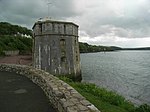
The South West Martello Tower
Pembroke Dock51°41′38″N 4°57′36″W / 51.693825784819°N 4.9600756864769°W / 51.693825784819; -4.9600756864769 (The South West Martello Tower )
18 February 1994 Martello tower
Fort Road (W End)[150]
14353
North East Martello Tower
Pembroke Dock51°41′46″N 4°56′51″W / 51.696205961495°N 4.9473791773459°W / 51.696205961495; -4.9473791773459 (North East Martello Tower )
18 February 1994 Martello tower
Front Street (N Side)[151]
14354
Dry-Moat Walls, Presely View (W end)
Pembroke Dock51°41′22″N 4°57′07″W / 51.689330116781°N 4.9518377478342°W / 51.689330116781; -4.9518377478342 (Dry-Moat Walls, Presely View (W end) )
18 January 1974 14371
Barracks Platform, Presely View (W Side)
Pembroke Dock51°41′22″N 4°57′07″W / 51.689330116781°N 4.9518377478342°W / 51.689330116781; -4.9518377478342 (Barracks Platform, Presely View (W Side) )
18 January 1994 14372
Dockyard Gates, the Dockyard
Pembroke Dock51°41′36″N 4°57′10″W / 51.693275711881°N 4.9526590610043°W / 51.693275711881; -4.9526590610043 (Dockyard Gates, the Dockyard )
18 January 1974 14377
Piers and Lodges (formerly listed with Dockyard Wall), the Dockyard
Pembroke Dock51°41′36″N 4°57′10″W / 51.693315502177°N 4.9528642603192°W / 51.693315502177; -4.9528642603192 (Piers and Lodges (formerly listed with Dockyard Wall), the Dockyard )
18 January 1974 14378
The Port Hotel (formerly listed as the Commodore Club), the Dockyard
Pembroke Dock51°41′36″N 4°57′11″W / 51.693345583501°N 4.9530977715249°W / 51.693345583501; -4.9530977715249 (The Port Hotel (formerly listed as the Commodore Club), the Dockyard )
18 January 1974 14379
Long Stable Range to South, the Dockyard
Pembroke Dock51°41′35″N 4°57′11″W / 51.693109572209°N 4.9531837007604°W / 51.693109572209; -4.9531837007604 (Long Stable Range to South, the Dockyard )
18 January 1974 14380
No 3, The Terrace, The Dockyard
Pembroke Dock51°41′35″N 4°57′07″W / 51.693085963764°N 4.9519809948437°W / 51.693085963764; -4.9519809948437 (No 3, The Terrace, The Dockyard )
18 January 1974 14381
The Graving Dock including Bollards and Capstans (formerly listed with 13 Building Slips and Carr Jet
Pembroke Dock51°41′49″N 4°57′20″W / 51.696825350907°N 4.955625697233°W / 51.696825350907; -4.955625697233 (The Graving Dock including Bollards and Capstans (formerly listed with 13 Building Slips and Carr Jet )
18 January 1974 Graving Dock
14393
Church of Saint David
Brawdy51°52′25″N 5°06′47″W / 51.873640991265°N 5.1130251700383°W / 51.873640991265; -5.1130251700383 (Church of Saint David )
3 January 1963 Church
14396
Forecourt, Railings, Piers and Gates, Meyrick Street (W side)
Pembroke Dock51°41′34″N 4°56′35″W / 51.692692092504°N 4.9429828554186°W / 51.692692092504; -4.9429828554186 (Forecourt, Railings, Piers and Gates, Meyrick Street (W side) )
14 July 1981 14420
Hescwm Mill/Felin Hescwm
Dinas Cross52°00′30″N 4°55′08″W / 52.008388477873°N 4.9189255630438°W / 52.008388477873; -4.9189255630438 (Hescwm Mill/Felin Hescwm )
18 March 1994 Mill
Situated some 200m inland from Aber Bach or Hesgwm cove, approached by narrow lane from Bwlchmawr. The mill lies to the south of the group of buildings.[152]
14535
Brynhenllan Chapel
Brynhenllan, Dinas Cross52°01′07″N 4°54′10″W / 52.018625629219°N 4.9028728497803°W / 52.018625629219; -4.9028728497803 (Brynhenllan Chapel )
17 November 1994 Chapel
14942
See more images
Manordeifi Old Church
Manordeifi52°03′30″N 4°35′08″W / 52.058426830413°N 4.5855706964089°W / 52.058426830413; -4.5855706964089 (Manordeifi Old Church )
24 November 1994 Church
Situated just above Teifi flood meadows, some 1.1km ESE of Llechryd Bridge.[153] [154]
15115
Terrace, Walls and Balustrades S of Ffynone House
Manordeifi52°01′04″N 4°33′46″W / 52.017766559928°N 4.562760209075°W / 52.017766559928; -4.562760209075 (Terrace, Walls and Balustrades S of Ffynone House )
24 November 1994 Terrace,Walls and Balustrade
15123
Cilrhue, Boncath
Boncath52°01′36″N 4°37′41″W / 52.026655922603°N 4.6280698165333°W / 52.026655922603; -4.6280698165333 (Cilrhue, Boncath )
25 January 1995 House
15388
The Stable and Coach House at Cilwendeg Farm
Capel Colman, Boncath52°01′08″N 4°35′28″W / 52.018872245523°N 4.5910568529359°W / 52.018872245523; -4.5910568529359 (The Stable and Coach House at Cilwendeg Farm )
23 January 1976 Stable
Situated to NE of farmhouse and N of mansion.[155]
15393
Four Mediaeval House at Upper Lamphey Park Farm
Lamphey51°40′33″N 4°51′27″W / 51.675813585886°N 4.8576074792807°W / 51.675813585886; -4.8576074792807 (Four Mediaeval House at Upper Lamphey Park Farm )
28 February 1995 Houses
About 500m S of Deerpark Lane, at NW end of the farm complex.[156]
15663
Cresselly House
Jeffreyston51°43′27″N 4°48′13″W / 51.724092619343°N 4.803653981481°W / 51.724092619343; -4.803653981481 (Cresselly House )
21 June 1971 House
Situated in its own grounds and approached along the N drive or through the stable courtyard to S. Faces E with terrace to W.[157] [158]
15933
Flimston Farmhouse
Castlemartin51°37′16″N 5°00′00″W / 51.621216565536°N 4.9999776299568°W / 51.621216565536; -4.9999776299568 (Flimston Farmhouse )
12 August 1995 Farmhouse (ruined)
On RAC Castlemartin Range, W of road to Stack Rocks.[159]
16590
Pricaston Farmhouse
Castlemartin51°37′42″N 5°00′36″W / 51.628471011857°N 5.0099222762133°W / 51.628471011857; -5.0099222762133 (Pricaston Farmhouse )
12 August 1995 Farmhouse (ruined)
On RAC Castlemartin Range, entered by Linney Gate.[160]
16604
West Set of Kilns
Penally51°40′06″N 4°43′09″W / 51.668354657754°N 4.7192281953739°W / 51.668354657754; -4.7192281953739 (West Set of Kilns )
26 April 1996 Kilns
At the S side of the main private road entering the Kiln Park caravan site, on the E side of the A4139. They are related to the extensive Black Rock quarries at their rear.[161]
16918
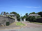
The Almshouse
Angle51°41′02″N 5°05′21″W / 51.683759484544°N 5.0891779428729°W / 51.683759484544; -5.0891779428729 (The Almshouse )
14 May 1970 Almshouse
At S of the village street, opposite the school.[162]
17149
Fort Popton
Angle51°41′34″N 5°02′52″W / 51.692883702612°N 5.047888172855°W / 51.692883702612; -5.047888172855 (Fort Popton )
26 January 1996 Fort
On the headland at the NE corner of Angle Bay.[163] [164]
17168
Thorne Island Fort
Angle51°41′30″N 5°07′03″W / 51.691735471353°N 5.1173773575108°W / 51.691735471353; -5.1173773575108 (Thorne Island Fort )
26 January 1996 Fort
Off N headland of West Angle Bay.[165] [166]
17169
See more images
Caldey Abbey
Tenby51°38′15″N 4°41′12″W / 51.637456252152°N 4.6867660596174°W / 51.637456252152; -4.6867660596174 (Caldey Abbey )
23 September 1996 Abbey
On hillside above the village, about 500m SE of the harbour.[167]
17324
Brewery
Stackpole51°37′39″N 4°55′27″W / 51.627426898853°N 4.9241875502202°W / 51.627426898853; -4.9241875502202 (Brewery )
2 August 1996 Brewery
17990
Eight-Arch Bridge
Stackpole51°37′22″N 4°55′25″W / 51.622756874867°N 4.9235547371431°W / 51.622756874867; -4.9235547371431 (Eight-Arch Bridge )
2 August 1996 Bridge
Built in 1797.[168] [169]
18003
See more images
West Blockhouse Fort
Dale51°41′18″N 5°09′29″W / 51.688236321912°N 5.1579448481414°W / 51.688236321912; -5.1579448481414 (West Blockhouse Fort )
12 October 1997 Fort
Situated on West Blockhouse Point, and reached by drive of some 1.5 km from Merryborough Farm, S of Dale.[170]
19148
Church of Saint Peter
Marloes, Marloes and St Brides51°43′45″N 5°11′41″W / 51.729288770519°N 5.1946140255681°W / 51.729288770519; -5.1946140255681 (Church of Saint Peter )
23 February 1998 Church
Situated at the SE end of the village of Marloes, above and to the S of the main street.[171]
19393
Blackpool Bridge
Slebech51°47′44″N 4°48′53″W / 51.795562499443°N 4.8146147390003°W / 51.795562499443; -4.8146147390003 (Blackpool Bridge )
26 February 1998 Bridge
Across the Eastern Cleddau adjacent to Blackpool Mill, at the highest navigable point of the river. The bridge is half in Martletwy Community and half in Slebech Community.[172]
19408
See more images
Sandy Haven House
St Ishmaels51°43′33″N 5°06′48″W / 51.725897807613°N 5.1132406347498°W / 51.725897807613; -5.1132406347498 (Sandy Haven House )
25 August 1998 House
Situated just S of Sandy Haven Farm some 450m NW of Sandy Haven.[173]
20351
Church of St Justinian
Trecwn51°57′57″N 4°58′51″W / 51.965742087869°N 4.9807386955951°W / 51.965742087869; -4.9807386955951 (Church of St Justinian )
11 October 1998 Church
About 1km E of Scleddau, beyond farmhouse at end of track beginning on E side of A40, near old quarry, then across field to churchyard.[174]
20818
Bethesda Baptist Church including vestry block attached to left
Haverfordwest51°48′07″N 4°58′23″W / 51.802046288175°N 4.9729672321815°W / 51.802046288175; -4.9729672321815 (Bethesda Baptist Church including vestry block attached to left )
14 May 1975 Church
Situated near the centre of Haverfordwest, on the E side of Barn Street near its junction with City Road and Perrots Road.[175]
22762
Lofted outbuilding, wings and gin-house at Camrose Home Farm
Camrose51°50′07″N 5°00′11″W / 51.835416226403°N 5.0031710241965°W / 51.835416226403; -5.0031710241965 (Lofted outbuilding, wings and gin-house at Camrose Home Farm )
30 April 2001 Farm building
Situated on the N side of the farm court at Camrose Home Farm.[176]
25159
No 2 Lexden Terrace
Tenby51°40′17″N 4°41′47″W / 51.671268314407°N 4.6963034710655°W / 51.671268314407; -4.6963034710655 (No 2 Lexden Terrace )
19 March 1951 House
Lexden Terrace lies at a tangent to the E side of St Julian’s Street, the rear overlooking Castle Sands, all set back behind a forecourt wall.[177]
26319
No 3 Lexden Terrace
Tenby51°40′17″N 4°41′47″W / 51.67132286708°N 4.6962777843167°W / 51.67132286708; -4.6962777843167 (No 3 Lexden Terrace )
19 March 1951 Lexden Terrace lies at a tangent to the E side of St Julian’s Street, the rear overlooking Castle Sands, all set back behind a forecourt wall.[178]
26320
No 4 Lexden Terrace
Tenby51°40′17″N 4°41′47″W / 51.671368438552°N 4.6962515638379°W / 51.671368438552; -4.6962515638379 (No 4 Lexden Terrace )
19 March 1951 Lexden Terrace lies at a tangent to the E side of St Julian’s Street, the rear overlooking Castle Sands, all set back behind a forecourt wall.[179]
26321
No 5 Lexden Terrace
Tenby51°40′17″N 4°41′46″W / 51.671423323955°N 4.6962114325282°W / 51.671423323955; -4.6962114325282 (No 5 Lexden Terrace )
19 March 1951 Lexden Terrace lies at a tangent to the E side of St Julian’s Street, the rear overlooking Castle Sands, all set back behind a forecourt wall.[180]
26322
No 4 Rock Terrace
Tenby51°40′15″N 4°41′49″W / 51.670886108448°N 4.6968882499392°W / 51.670886108448; -4.6968882499392 (No 4 Rock Terrace )
19 March 1951 House
Set back from the street line on the S side of St Julian’s Street with rear facade overlooking Iron Bar Sands.[181]
26340
No 6 Lexden Terrace (Lexden House)
Tenby51°40′17″N 4°41′46″W / 51.671486857806°N 4.6961862792468°W / 51.671486857806; -4.6961862792468 (No 6 Lexden Terrace (Lexden House) )
19 March 1951 Lexden Terrace lies at a tangent to the E side of St Julian’s Street, No 6, the farthest, is set back in a separate forecourt.[182]
26349
Former Tenby Market Cross and well-chamber
Tenby51°40′37″N 4°42′16″W / 51.676887509343°N 4.70456478179°W / 51.676887509343; -4.70456478179 (Former Tenby Market Cross and well-chamber )
28 March 2002 Market cross
Situated at the N end of the water garden in the centre of Merlins Gardens.[183]
26423
Stack Rock Fort
Herbrandston51°42′09″N 5°05′32″W / 51.702461671581°N 5.0921174029514°W / 51.702461671581; -5.0921174029514 (Stack Rock Fort )
3 April 2004 Fort
On Stack Rock island in Milford Haven some 2.7km S of Herbranston village.[184] [185]
82592
See more images
The defensible barracks at South Hook Fort
Herbrandston51°42′29″N 5°05′01″W / 51.708179596406°N 5.0836910447829°W / 51.708179596406; -5.0836910447829 (The defensible barracks at South Hook Fort )
3 April 2004 Barracks
In a prominent position some 200m N of the cliffs at South Hook Point.[186] [187]
82593
Higgon’s Well
Uzmaston and Boulston51°47′49″N 4°57′28″W / 51.796857142735°N 4.9576852764667°W / 51.796857142735; -4.9576852764667 (Higgon’s Well )
16 July 2004 Well
On the E side of the estuary of the Cleddau Wen some 700m S of Haverfordwest station.[188]
82964
Lancych
Clydau52°00′59″N 4°32′13″W / 52.016498626171°N 4.5370794369895°W / 52.016498626171; -4.5370794369895 (Lancych )
26 July 2004 House
Set in its own extensive grounds on the S side of the Afon Cych some 200m W of Pont Glan Cych.[189]
82984
10 Goat Street
Haverfordwest51°48′02″N 4°58′12″W / 51.80042°N 4.97009°W / 51.80042; -4.97009 (10 Goat Street )
7 January 1974 House
Large 18th-century terraced house, attached to the similar Grade II* listed No. 8[190] [191]
87060
Gateway and walls to ‘The Abbey’
Marloes and St Brides51°45′09″N 5°11′01″W / 51.752540564774°N 5.1836772260989°W / 51.752540564774; -5.1836772260989 (Gateway and walls to ‘The Abbey’ )
23 February 1998 Gateway
Situated at St Brides Green, some 200m SW of St Brides Cross and some 200m SE of the coast at St Brides Haven.[192]
87482
Church of St Rhian
Llanrhian51°56′19″N 5°10′26″W / 51.938580766563°N 5.1739244827999°W / 51.938580766563; -5.1739244827999 (Church of St Rhian )
1 March 1963 Church
Situated in Llanrhian village about 100m NE of crossroads.[193]
87554


Recent Comments