Name
LocationGrid Ref. [note 1]
Date Listed
Function
Notes
Reference Number
Image
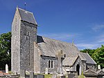
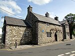
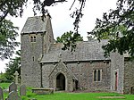
Church of St James
Wick51°26′18″N 3°33′02″W / 51.43837°N 3.55046°W / 51.43837; -3.55046 (Church of St James )
26 July 1963 Church
Located on the N side of Church Street in the centre of Wick Village. Located in a roughly rectangular churchyard.
11221
See more images
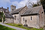
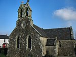
Church of St Bridget
St Brides Major51°27′48″N 3°35′36″W / 51.46324°N 3.59329°W / 51.46324; -3.59329 (Church of St Bridget )
26 July 1963 Church
Set within a polygonal churchyard on the hillside, towards the NW end of St. Brides Major.
11226
See more images
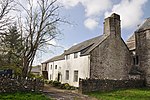
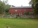
Ewenny Priory (house)
Ewenny51°29′18″N 3°34′04″W / 51.48846°N 3.56777°W / 51.48846; -3.56777 (Ewenny Priory (house) )
26 July 1963 Church
About 1km northeast of Ewenny village, a five-bay Georgian mansion to south of Ewenny Priory.
11249
Flemingston Court Farmhouse
St Athan51°25′14″N 3°24′55″W / 51.42069°N 3.41520°W / 51.42069; -3.41520 (Flemingston Court Farmhouse )
16 December 1952 Farmhouse
On the south side of the Churchyard of the Church of St Michael the Archangel.
13130
Gileston Manor
Gileston (St Athan)51°23′39″N 3°24′48″W / 51.39417°N 3.41333°W / 51.39417; -3.41333 (Gileston Manor )
16 December 1952 House
In the centre of Gileston village and immediately west of the Church of St Giles.
13131
Great House (Ty Mawr), Aberthin
Aberthin51°28′04″N 3°25′32″W / 51.46791°N 3.42551°W / 51.46791; -3.42551 (Great House (Ty Mawr), Aberthin )
16 December 1952 House
In large walled garden about 300m E of centre of Aberthin; on N side of Nant Aberthin.
13132
Llanmaes House
Llan Maes51°24′55″N 3°27′59″W / 51.41524°N 3.46634°W / 51.41524; -3.46634 (Llanmaes House )
16 December 1952 House
In the centre of Llanmaes village facing the east end of the Church of St. Cattwg.
13134
Castleton Farmhouse
St Athan51°24′22″N 3°24′16″W / 51.40601°N 3.40449°W / 51.40601; -3.40449 (Castleton Farmhouse )
16 December 1952 Farmhouse
About 700m north-east of the Church of St. Athan and approached down a cul-de-sac.
13140
Parish church of St Michael and All Angels, Llanmihangel
Llanmihangel, Llandow51°26′12″N 3°28′01″W / 51.436805°N 3.466887°W / 51.436805; -3.466887 (Parish church of St Michael and All Angels, Llanmihangel )
22 February 1963 Church
13141
See more images
Church of St Brise
St Athan51°24′45″N 3°25′52″W / 51.41241°N 3.43121°W / 51.41241; -3.43121 (Church of St Brise )
22 February 1963 Church
It is within the boundary fence of RAF St Athan on the south side of a right-angled bend in the road and hidden by trees.
13142
Church of St Giles
Gileston (St Athan)51°23′39″N 3°24′47″W / 51.39426°N 3.41303°W / 51.39426; -3.41303 (Church of St Giles )
22 February 1963 Church
In the centre of Gileston village and immediately to the east of Gileston Manor.
13143
See more images
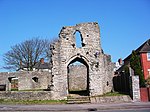
St Quintin’s Castle (Llanblethian Castle)
Cowbridge with Llanblethian51°27′27″N 3°27′23″W / 51.45754°N 3.45639°W / 51.45754; -3.45639 (St Quintin’s Castle (Llanblethian Castle) )
22 February 1963 Castle
About 450m NE of Llanblethian church on spur of land above loop in River Thaw.
13146
See more images
Holy Trinity Church
Llandow51°26′56″N 3°31′24″W / 51.44899°N 3.52347°W / 51.44899; -3.52347 (Holy Trinity Church )
22 February 1963 Church
13148
See more images
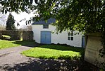
Church Farmhouse (also known as The Glebe)
Llandow51°26′57″N 3°31′25″W / 51.44927°N 3.52354°W / 51.44927; -3.52354 (Church Farmhouse (also known as The Glebe) )
22 February 1963 Farmhouse
Situated immediately to the NE of the Parish Church of Holy Trinity, in the centre of Llandow village. Set within its own gardens to front and rear, bounded by a low rubble wall.
13149
Sutton Farmhouse
Llandow51°26′24″N 3°31′12″W / 51.44003°N 3.51988°W / 51.44003; -3.51988 (Sutton Farmhouse )
22 February 1963 Farmhouse
13151
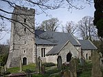
Church of St Cattwg
Llan Maes51°24′55″N 3°28′01″W / 51.41522°N 3.46707°W / 51.41522; -3.46707 (Church of St Cattwg )
22 February 1963 Church
In the centre of Llanmaes village.
13160
See more images
Church of St Brynach
Penllyn51°27′41″N 3°28′13″W / 51.46126°N 3.47041°W / 51.46126; -3.47041 (Church of St Brynach )
22 February 1963 Church
At the very southern point of the community and about 1.5 km south of Penllyn village.
13164
See more images
Church of St Hilary
St Hilary (Llanfair)51°26′59″N 3°25′02″W / 51.449799°N 3.417236°W / 51.449799; -3.417236 (Church of St Hilary )
22 February 1963 Church
13170
See more images
Old Beaupre Farmhouse
Llanfair51°26′20″N 3°25′39″W / 51.438767°N 3.427469°W / 51.438767; -3.427469 (Old Beaupre Farmhouse )
22 February 1963 Farmhouse
Located at the SE corner of Old Beaupre Castle, attached to the E end of the S range of the ruined manor house, aligned on a N/S axis.
13172
Church of St Cadoc, Cadoxton
Cadoxton, Barry51°24′59″N 3°15′09″W / 51.416463°N 3.252580°W / 51.416463; -3.252580 (Church of St Cadoc, Cadoxton )
18 September 1962 Church
13175
See more images
Church of St Dyfran and St Teilo, Merthyr Dyfan
Merthyr Dyfan, Barry51°25′02″N 3°16′27″W / 51.41723°N 3.27413°W / 51.41723; -3.27413 (Church of St Dyfran and St Teilo, Merthyr Dyfan )
18 September 1962 Church
13177
Barry Castle
Barry51°23′48″N 3°17′38″W / 51.39668°N 3.29381°W / 51.39668; -3.29381 (Barry Castle )
18 September 1962 Castle
Remains of a fortified manor dating from circa 1300-1350. At junction of Porth-y-Castell and Park Road, Barry.[3] [4]
13180
See more images
Cowbridge town walls
Cowbridge with Llanblethian51°27′42″N 3°27′05″W / 51.46156°N 3.45137°W / 51.46156; -3.45137 (Cowbridge town walls )
12 May 1963 Town wall
On east side of The Butts, from rear of Mason’s Arms, to bastion at southwest angle, thence along north side of Town Mill Road.
13181
South Gate (Porth y Felin)
Cowbridge with Llanblethian51°27′40″N 3°27′02″W / 51.46118°N 3.45051°W / 51.46118; -3.45051 (South Gate (Porth y Felin) )
12 May 1963 Gate
At south end of Church Street.
13183
See more images
Cowbridge Grammar School
Cowbridge with Llanblethian51°27′40″N 3°27′01″W / 51.461247°N 3.450195°W / 51.461247; -3.450195 (Cowbridge Grammar School )
18 April 1973 Apartments
To south of Parish Church.
13185
See more images
Cowbridge Town Hall
Cowbridge51°27′43″N 3°26′49″W / 51.46193°N 3.44706°W / 51.46193; -3.44706 (Cowbridge Town Hall )
12 May 1963 Town hall
Prominently sited near the east end of High Street, with rear elevations to Town Hall Square.
13200
See more images
The Great House, Cowbridge
Cowbridge51°27′43″N 3°26′54″W / 51.46185°N 3.44826°W / 51.46185; -3.44826 (The Great House, Cowbridge )
12 May 1963 16th century L-shaped hall house, two storeys with attic, about 80m east of junction with Church Street.[5] [6]
13221
Boverton Place including attached bee-boles
Llantwit Major51°24′18″N 3°27′51″W / 51.404972°N 3.464099°W / 51.404972; -3.464099 (Boverton Place including attached bee-boles )
9 October 1982 On the south side of Boverton village centre.
13245
Llantwit Major Town Hall
Llantwit Major51°24′29″N 3°29′10″W / 51.408067°N 3.486053°W / 51.408067; -3.486053 (Llantwit Major Town Hall )
22 February 1963 Town hall
In the centre of Llantwit Major.
13248
Dovecote, Llantwit Major
Llantwit Major51°24′25″N 3°29′19″W / 51.407008°N 3.488722°W / 51.407008; -3.488722 (Dovecote, Llantwit Major )
22 February 1963 Dovecote
About 110m south-west of the Church of St. Illtud.
13253
The Gatehouse, Llantwit Major
Llantwit Major51°24′27″N 3°29′19″W / 51.407532°N 3.488537°W / 51.407532; -3.488537 (The Gatehouse, Llantwit Major )
22 February 1963 Gatehouse
About 80m south-west of the Church of St. Illtud. The building is on the roadside and is sited near the south-east corner of the ‘Monastery’ field.
13254
Old Swan Inn, Llantwit Major
Llantwit Major51°24′30″N 3°29′10″W / 51.40827°N 3.48599°W / 51.40827; -3.48599 (Old Swan Inn, Llantwit Major )
16 December 1952 Public house
In the centre of Llantwit Major just to the north of The Town Hall.
13260
See more images
Ty-Mawr (or Great House)
Llantwit Major51°24′45″N 3°29′13″W / 51.41261°N 3.48686°W / 51.41261; -3.48686 (Ty-Mawr (or Great House) )
22 February 1963 About 500m north of the Church of St. Illtud at the northern entrance to the town.
13271
St Mary’s Church
Monknash, St Donats51°25′23″N 3°33′11″W / 51.42294°N 3.55314°W / 51.42294; -3.55314 (St Mary’s Church )
22 February 1963 Church
About 200m east of the road junction in the centre of Monknash on the south side of the road going towards St Donats.
13311
See more images
St Peter’s Church, Penarth
Penarth51°25′41″N 3°11′49″W / 51.42802°N 3.19704°W / 51.42802; -3.19704 (St Peter’s Church, Penarth )
19 November 1990 Church
On east of minor road branching off Sully Road. To north of Cogan Old Hall Farm.[7] [8]
13370
Whitehouse Cottage
Barry51°23′21″N 3°17′25″W / 51.38923°N 3.29031°W / 51.38923; -3.29031 (Whitehouse Cottage )
2 July 1978 House
The oldest inhabited house in Barry, dating from the late 16th century.[9] [10]
13400
Llandough Castle
Llandough51°26′49″N 3°26′52″W / 51.44705°N 3.44789°W / 51.44705; -3.44789 (Llandough Castle )
13 May 1981 Castle
13408
The gatehouse, Llandough Castle (including attached boundary walls)
Llanfair51°26′49″N 3°26′52″W / 51.44683°N 3.44772°W / 51.44683; -3.44772 (The gatehouse, Llandough Castle (including attached boundary walls) )
16 December 1952 Gatehouse
13421
Great House with Forecourt Walls & Gatepiers
Llanblethian51°27′19″N 3°27′24″W / 51.45536°N 3.45663°W / 51.45536; -3.45663 (Great House with Forecourt Walls & Gatepiers )
17 May 1988 House dating from circa 1600 with a facade dated 1703, about 100m southwest of bridge over River Thaw.[11] [12]
13424
Barn and stable to east of Llanmithangel Place, Llanmithangel
Llandow51°26′15″N 3°27′58″W / 51.43751°N 3.46610°W / 51.43751; -3.46610 (Barn and stable to east of Llanmithangel Place, Llanmithangel )
19 September 1989 Farm buildings
13436
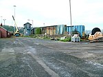
Barry Dock Offices
Barry51°24′04″N 3°15′48″W / 51.40117°N 3.26329°W / 51.40117; -3.26329 (Barry Dock Offices )
30 July 1990 Prominently sited, overlooking Docks to the south, below the town on a flat site near Castleisland Point; railway immediately to rear.
13443
See more images
Pedestal and statue of David Davies
Barry51°24′03″N 3°15′48″W / 51.40077°N 3.26336°W / 51.40077; -3.26336 (Pedestal and statue of David Davies )
30 July 1990 Statue
Statue of engineer, industrialist and entrepreneur David Davies (1818-1890). On the seaward side of the road in front of Barry Dock Board Offices, overlooking the docks.[13] [14]
13445
See more images
Sully Hospital
Sully51°24′01″N 3°14′12″W / 51.40022°N 3.23675°W / 51.40022; -3.23675 (Sully Hospital )
6 November 1990 Reached along a byroad one-and-a-half km southwest from B4267 near west outskirts of Sully. The hospital is sited in extensive, wooded grounds at Hayes Point overlooking the Bristol Channel.
13447
Dyffryn House
St Nicholas and Bonvilston51°26′37″N 3°18′11″W / 51.443499°N 3.303092°W / 51.443499; -3.303092 (Dyffryn House )
15 September 1992 Set within the large public grounds of Dyffryn Gardens; 2km to south of St Nicholas.
13469
See more images
Garnllywd Farmhouse, Lannfythin
Llancarfan51°25′58″N 3°21′27″W / 51.43267°N 3.35754°W / 51.43267; -3.35754 (Garnllywd Farmhouse, Lannfythin )
14 February 1952 Farmhouse
13592
Treguff Farmhouse, Treguff
Llancarfan51°25′51″N 3°23′44″W / 51.430727°N 3.395484°W / 51.430727; -3.395484 (Treguff Farmhouse, Treguff )
14 February 1952 Farmhouse
13593
Trewallter Fawr Farmhouse
Walterston51°25′53″N 3°20′27″W / 51.431509°N 3.340843°W / 51.431509; -3.340843 (Trewallter Fawr Farmhouse )
28 January 1963 Farmhouse
Set on the east side of the Walterston hamlet to the northeast of the Llancarfan village.
13606
St Illtyd’s parish church, Llantrithyd
Llantrithyd51°26′46″N 3°22′38″W / 51.446041°N 3.377244°W / 51.446041; -3.377244 (St Illtyd’s parish church, Llantrithyd )
28 January 1963 Church
13609
See more images
Church of St Cadoc, Pendoylan
Pendoylan51°28′53″N 3°21′19″W / 51.48130366683°N 3.3552214524103°W / 51.48130366683; -3.3552214524103 (Church of St Cadoc, Pendoylan )
28 January 1963 Church
13613
See more images
The Blue Anchor Inn
Rhoose51°23′28″N 3°23′18″W / 51.391004509182°N 3.3882531272316°W / 51.391004509182; -3.3882531272316 (The Blue Anchor Inn )
28 January 1963 Restaurant
In the centre of East Aberthaw village on the east side of the road.
13614
St Mary’s Church, Penmark
Rhoose51°24′39″N 3°21′19″W / 51.410824454652°N 3.3551490786726°W / 51.410824454652; -3.3551490786726 (St Mary’s Church, Penmark )
28 January 1963 Church
In the centre of Penmark village on the north side of the road to Barry.
13617
See more images
Church of St Peter, Peterston Super Ely
Peterston Super Ely51°28′45″N 3°19′21″W / 51.479169988775°N 3.3223971348052°W / 51.479169988775; -3.3223971348052 (Church of St Peter, Peterston Super Ely )
28 January 1963 Church
In the village centre set within a large walled rectangular churchyard with entrances at SE and SW.
13618
See more images
St Curig’s Church
Porthkerry51°23′28″N 3°19′13″W / 51.391125636377°N 3.3202589908065°W / 51.391125636377; -3.3202589908065 (St Curig’s Church )
28 January 1963 Church
On the eastern boundary of the community set to the south-east of Porthkerry village green.
13619
Church of St Andrew
St Andrews Major (Dinas Powys)51°26′08″N 3°14′26″W / 51.43565°N 3.24069°W / 51.43565; -3.24069 (Church of St Andrew )
28 January 1963 Church
On low-lying ground in the centre of the rural hamlet (northwest of the urban development of Dinas Powys) standing in a roughly rectangular churchyard with retaining wall incorporating stone stiles.[15] [16]
13625
The Old Rectory
St Andrews Major (Dinas Powys)51°26′07″N 3°14′26″W / 51.43522°N 3.24062°W / 51.43522; -3.24062 (The Old Rectory )
28 January 1963 (ex)House
Ex priest’s house probably dating back to the 15th century, now used as a garage. Situated southwest of the church, within the grounds of The Rectory and reached by a drive through that property.[17] [18]
13626
Church of St George, St Georges Super Ely
St Georges Super Ely51°28′54″N 3°17′27″W / 51.481706603337°N 3.2908742400847°W / 51.481706603337; -3.2908742400847 (Church of St George, St Georges Super Ely )
28 January 1963 Church
A little to the E of the hamlet of St Georges which developed round Castle Farm, main approach from N, the centre of a small cluster of buildings grouped round the churchyard, close to the Ely River.
13633
Church of St Bleiddian
Wenvoe51°26′54″N 3°16′54″W / 51.44828511371°N 3.2816997940536°W / 51.44828511371; -3.2816997940536 (Church of St Bleiddian )
28 January 1963 Church
In the centre of St Lythans hamlet, set back from the road, reached by a short track and surrounded by a roughly circular walled churchyard incorporating stone stiles.
13635
See more images
Parish church of St Nicholas, St Nicholas
St Nicholas51°27′39″N 3°18′40″W / 51.460963306891°N 3.3110027068773°W / 51.460963306891; -3.3110027068773 (Parish church of St Nicholas, St Nicholas )
28 January 1963 Church
13636
Church of St Mary, Wenvoe
Wenvoe51°26′47″N 3°15′53″W / 51.446391077808°N 3.2648535446914°W / 51.446391077808; -3.2648535446914 (Church of St Mary, Wenvoe )
28 January 1963 Church
In the centre of Wenvoe village, fronting the main thoroughfare, in a roughly rectangular churchyard entered through a stone arch at NE.
13643
See more images
Coach-house and stables at Coedarhydyglyn
St Georges Super Ely51°28′06″N 3°17′24″W / 51.468443766488°N 3.2900247123723°W / 51.468443766488; -3.2900247123723 (Coach-house and stables at Coedarhydyglyn )
13 September 1994 To the NE of the main house, on the same plateau.
14865
Sliding Bridge at N entrance to Basin
Barry51°23′47″N 3°15′46″W / 51.396497996724°N 3.2628297581838°W / 51.396497996724; -3.2628297581838 (Sliding Bridge at N entrance to Basin )
13 February 1996 Bridge
Spans N entrance to Dock Basin.
16562
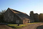
Ewenny Priory Barn
Ewenny51°29′20″N 3°34′08″W / 51.488798°N 3.568877°W / 51.488798; -3.568877 (Ewenny Priory Barn )
3 March 1998 Barn
Forming part of the north boundary of Ewenny Priory house courtyard, backing onto Abbey Road, just south of Ewenny River and west of the Priory.[19] [20]
19463
East Precinct Wall at Ewenny Priory (house)
Ewenny51°29′19″N 3°34′02″W / 51.48872°N 3.56716°W / 51.48872; -3.56716 (East Precinct Wall at Ewenny Priory (house) )
3 March 1998 Aligned roughly north/south in Ewenny Priory (house) garden, joining churchyard at southest and former southeast gatehouse.
19465
Former Southeast Tower at Ewenny Priory (house)
Ewenny51°29′18″N 3°34′01″W / 51.488285°N 3.566886°W / 51.488285; -3.566886 (Former Southeast Tower at Ewenny Priory (house) )
3 March 1998 At the southeast corner of Ewenny Priory (house) lawned garden adjacent to the haha forming the south boundary.
19467
Medieval fishpool in west part of Ewenny Priory (house) gardens
Ewenny51°29′17″N 3°34′09″W / 51.48798°N 3.56926°W / 51.48798; -3.56926 (Medieval fishpool in west part of Ewenny Priory (house) gardens )
3 March 1998 Fishpond
Circular fishpond in the walled garden in the west part of the Priory complex.[21] [22]
19469
Ty Maen
St Brides Major51°28′54″N 3°35′40″W / 51.481719520396°N 3.5943124312705°W / 51.481719520396; -3.5943124312705 (Ty Maen )
3 March 1999 House
Located off the S side of the B4524 road which leads from Bridgend to Ogmore-by-Sea. The house is just W of the community boundary with Ewenny, and is cut into the hillside with sharp drops to the N and E.
21775
Old Leckwith Bridge
Canton / Michaelston51°28′11″N 3°12′43″W / 51.469754543899°N 3.2118982722425°W / 51.469754543899; -3.2118982722425 (Old Leckwith Bridge )
2 December 1952 Bridge
At the S end of Canton crossing the River Ely into Leckwith; at the foot of Leckwith Woods and adjacent to the later bridge carrying the B4267
26487
Walls, Gatepiers and Gates of Llanmaes House
Llan Maes51°24′55″N 3°28′00″W / 51.415182715196°N 3.4665825980712°W / 51.415182715196; -3.4665825980712 (Walls, Gatepiers and Gates of Llanmaes House )
21 July 2003 Walls and Gates
Surrounding the front and rear gardens of Llanmaes House.
81305
Church of St Michael the Archangel, St Athan
Flemingston, St Athan51°25′16″N 3°24′55″W / 51.421093174893°N 3.4152255251895°W / 51.421093174893; -3.4152255251895 (Church of St Michael the Archangel, St Athan )
9 March 2004 Church
In the centre of Flemingston village.
83115
Church Farmhouse (aka Glebe Farm)
Rhoose51°23′30″N 3°19′16″W / 51.391745805768°N 3.3210817327852°W / 51.391745805768; -3.3210817327852 (Church Farmhouse (aka Glebe Farm) )
30 September 2004 Farmhouse
On the north side of the Porthkerry village green about 50m from the Church of St Curig
83147
Outbuilding to north of Church Farmhouse
Rhoose51°23′31″N 3°19′16″W / 51.391906801136°N 3.3211582361448°W / 51.391906801136; -3.3211582361448 (Outbuilding to north of Church Farmhouse )
30 September 2004 Farm building
In the garden on the north side of Church Farmhouse.
83157
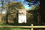
Watchtower at Fonmon Castle
Rhoose51°24′09″N 3°22′13″W / 51.402600264438°N 3.3702886987752°W / 51.402600264438; -3.3702886987752 (Watchtower at Fonmon Castle )
14 February 1952 Watchtower
About 200m south of Fonmon Castle.
83166


Recent Comments