National Register of Historic Places listings in Iowa
From Wikipedia, the free encyclopedia

This is a list of properties and historic districts in Iowa that are listed on the National Register of Historic Places. There are listings in all of Iowa’s 99 counties, adding up to over 2,300 total.
This National Park Service list is complete through NPS recent listings posted March 31, 2023.[1]
Current listings by county[edit]
The following are approximate tallies of current listings by county. These counts are based on entries in the National Register Information Database as of April 24, 2008[2] and new weekly listings posted since then on the National Register of Historic Places web site.[3] There are frequent additions to the listings and occasional delistings and the counts here are approximate and not official. New entries are added to the official Register on a weekly basis.[4] Also, the counts in this table exclude boundary increase and decrease listings which modify the area covered by an existing property or district and which carry a separate National Register reference number. The numbers of NRHP listings in each county are documented by tables in each of the individual county list-articles.
Former listing[edit]
Former listing[edit]
| [7] | Name on the Register | Image | Date listed[8] | Location | City or town | Description |
|---|---|---|---|---|---|---|
| 1 | J.V. Banta House |
 |
July 14, 1983 (#83000348) |
222 McLane St. 41°01′49″N 93°46′08″W / 41.030319°N 93.768862°W |
Osceola | |
| 2 | Chicago, Burlington and Quincy Depot |
 |
January 8, 2009 (#08001283) |
215 N. Main St. 41°02′12″N 93°45′56″W / 41.03663°N 93.76566°W |
Osceola | Part of the Advent & Development of Railroads in Iowa Multiple Property Submission |
| 3 | George H. and Alice Spaulding Cowles House |
 |
December 20, 2006 (#06001161) |
229 W. Cass St. 41°02′03″N 93°46′09″W / 41.034167°N 93.769167°W |
Osceola | |
| 4 | John and Mary Jane Kyte Farmstead District |
 |
September 14, 2000 (#00001074) |
2875 Mormon Trail Rd. 40°56′09″N 93°39′22″W / 40.935833°N 93.656111°W |
Weldon | |
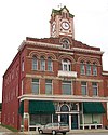
| 5 | Osceola Masonic Block |
 |
July 6, 2010 (#10000421) |
101-103 South Main St. 41°02′05″N 93°45′55″W / 41.034722°N 93.765278°W |
Osceola | |
| 6 | Marcellus Luther and Julia Protzman Temple House |
 |
April 4, 1996 (#96000361) |
502 S. Main St. 41°01′46″N 93°45′57″W / 41.029444°N 93.765833°W |
Osceola | |
| 7 | Osceola Commercial Historic District |
 |
January 19, 2018 (#100001971) |
S Fillmore, N & S Main, E & W Jefferson & E & W Washington Sts. 41°02′04″N 93°45′59″W / 41.034346°N 93.766523°W |
Osceola | |
| 8 | Dickinson Webster House |
 |
July 20, 1977 (#77000501) |
609 W. Jefferson St. 41°02′12″N 93°46′02″W / 41.036667°N 93.767222°W |
Osceola |
Former listing[edit]
| [7] | Name on the Register | Image | Date listed[8] | Location | City or town | Description |
|---|---|---|---|---|---|---|
| 1 | All Saints Catholic Church |
 |
December 7, 2000 (#00001478) |
420 N. Fremont 41°30′25″N 94°19′02″W / 41.506944°N 94.317222°W |
Stuart | |
| 2 | John Cretsinger House | October 7, 1998 (#98001206) |
1363 Burl Ln. 41°48′46″N 94°42′52″W / 41.812778°N 94.714444°W |
Coon Rapids | ||
| 3 | Roswell and Elizabeth Garst Farmstead Historic District | August 12, 2009 (#09000610) |
1390 Iowa Highway 141 41°50′55″N 94°38′43″W / 41.848544°N 94.64515°W |
Coon Rapids | ||
| 4 | Masonic Temple Building |
 |
April 12, 1996 (#96000400) |
1311 N. 2nd St. 41°30′18″N 94°19′07″W / 41.505°N 94.318611°W |
Stuart | |
| 5 | Octagon Barn, Richland Township | June 30, 1986 (#86001433) |
Off Iowa Highway 141 41°49′24″N 94°20′10″W / 41.823333°N 94.336111°W |
Richland Township | ||
| 6 | Sexton Hotel |
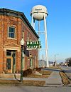 |
December 18, 2013 (#13000924) |
203 E. Front Street 41°30′14″N 94°19′00″W / 41.503832°N 94.316748°W |
Stuart | |
| 7 | Springbrook State Park, Civilian Conservation Corps Area |
 |
November 15, 1990 (#90001671) |
Junction of Iowa Highway 384 and County Highway F25 41°46′38″N 94°27′54″W / 41.777222°N 94.465°W |
Guthrie Center | |
| 8 | Yale High School Gymnasium | December 28, 2018 (#100003261) |
414 Lincoln St. 41°46′28″N 94°21′26″W / 41.774408°N 94.357173°W |
Yale |
Former listings[edit]
| [7] | Name on the Register | Image | Date listed[8] | Location | City or town | Description |
|---|---|---|---|---|---|---|
| 1 | Bohemian Savings Bank |
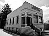 |
September 13, 1990 (#88002806) |
Main St. 43°13′05″N 92°05′26″W / 43.218056°N 92.090556°W |
Protivin | |
| 2 | Cresco Opera House |
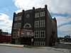 |
August 27, 1981 (#81000245) |
115 W. 2nd Ave. 43°21′12″N 92°08′04″W / 43.353333°N 92.134444°W |
Cresco | |
| 3 | James C. Fellows House |
 |
June 21, 1982 (#82002621) |
Main St. 43°22′02″N 92°33′05″W / 43.367222°N 92.551389°W |
Riceville | |
| 4 | Howard County Courthouse |
 |
July 2, 1981 (#81000246) |
Elm St. 43°22′26″N 92°07′03″W / 43.373889°N 92.1175°W |
Cresco | |
| 5 | Kellow House |
 |
November 22, 1977 (#77000517) |
324 4th Ave., W. 43°22′33″N 92°07′16″W / 43.375833°N 92.121111°W |
Cresco | |
| 6 | Lime Springs Mill Complex |
 |
April 11, 1977 (#77000518) |
Former Iowa Highway 157 43°27′54″N 92°16′45″W / 43.465°N 92.279167°W |
Lime Springs | |
| 7 | Polygonal Barn, New Oregon Township | June 30, 1986 (#86001437) |
Off Iowa Highway 39 43°13′32″N 92°07′38″W / 43.225556°N 92.127222°W |
New Oregon Township |
Former listing[edit]
Former listing[edit]
Former listings[edit]
| [7] | Name on the Register | Image | Date listed | Date removed | Location | City or town | Description |
|---|---|---|---|---|---|---|---|
| 1 | Turner Hall | January 22, 1975 (#75000691) |
June 21, 2007 | SE corner of Keil and 2nd Streets | Holstein | Demolished in March, 1975[10] |
Former listings[edit]
Former listing[edit]
Former listings[edit]
Former listings[edit]
| [7] | Name on the Register | Image | Date listed[8] | Location | City or town | Description |
|---|---|---|---|---|---|---|
| 1 | Chicago, Milwaukee, and St. Paul Railroad-Grafton Station |
 |
June 23, 1976 (#76000815) |
Iowa Highway 337 43°19′33″N 93°04′13″W / 43.325833°N 93.070278°W |
Grafton | |
| 2 | First Methodist Episcopal Church |
 |
August 16, 2000 (#00000985) |
401 Second Street 43°21′07″N 93°12′40″W / 43.351944°N 93.211111°W |
Kensett | |
| 3 | Northwood Central Avenue Historic District |
 |
September 19, 2006 (#06000857) |
Roughly Central Avenue, W. near 5th St. to 9th St. on the east 43°26′46″N 93°13′22″W / 43.446111°N 93.222778°W |
Northwood | |
| 4 | Old Worth County Courthouse |
 |
July 2, 1981 (#81000276) |
921 Central Avenue 43°26′38″N 93°13′07″W / 43.443889°N 93.218611°W |
Northwood | |
| 5 | Rhodes Mill |
 |
November 24, 1978 (#78001274) |
Main Street 43°15′50″N 93°25′16″W / 43.263889°N 93.421111°W |
Fertile | |
| 6 | Worth County Courthouse |
 |
July 2, 1981 (#81000705) |
Central Avenue between 10th and 11th Streets 43°26′40″N 93°13′03″W / 43.444444°N 93.2175°W |
Northwood |
See also[edit]
References[edit]
- ^ National Park Service, United States Department of the Interior, “National Register of Historic Places: Weekly List Actions”, retrieved March 31, 2023.
- ^ “National Register Information System”. National Register of Historic Places. National Park Service. April 24, 2008.
- ^ “National Register of Historic Places: Weekly List Actions”. National Park Service. Retrieved January 2, 2009.
- ^ Weekly List Actions, National Register of Historic Places website
- ^ The Vander Veer Park Historic District is split between east and west Davenport. The Davenport Downtown Commercial Historic District is split between downtown and west Davenport.
- ^ Effigy Mounds National Monument is split between Allamakee and Clayton counties; Le Grand Bridge (1896) is split between Marshall and Tama counties; County Line Bridge is split between Louisa and Washington counties; Bridgeport Bridge is split between Des Moines and Lee counties
- ^ a b c d e f g h i j k l m n o p q r s t u v w x y z aa ab ac ad ae af ag ah ai aj ak Numbers represent an alphabetical ordering by significant words. Various colorings, defined here, differentiate National Historic Landmarks and historic districts from other NRHP buildings, structures, sites or objects.
- ^ a b c d e f g h i j k l m n o p q r s t u v w x y z The eight-digit number below each date is the number assigned to each location in the National Register Information System database, which can be viewed by clicking the number.
- ^ “Welcome to Panora, Iowa — Home to Beautiful Lake Panorama and the Raccoon River Valley Trail!!”. Archived from the original on 2012-02-07. Retrieved 2012-01-09.
- ^ “Turner Hall Now Only a Memory”. The Sioux City Journal. March 3, 1975. p. A2. Retrieved June 25, 2022 – via Newspapers.com.
- ^ Springer, Arthur. History of Louisa County Iowa From Its Earliest Settlement to 1912. Vol. 1. Chicago: Clarke, 1912, 13.
- ^ Address derived from this Louisa County Conservation Board page; the NRIS lists the site as “Address Restricted”.
- ^ “The Springer House”. www.louisacountyhistory.com. Archived from the original on 8 December 2012. Retrieved 15 January 2022.
- ^ “Slipping away”. Muscatine Journal. September 27, 1997. p. 9. Retrieved June 26, 2022 – via Newspapers.com.
- ^ Vis, Robert B., and Dale R. Henning. “A Local Sequence for Mill Creek Sites in the Little Sioux River Valley“. Plains Anthropologist 14.46 (1969): 253-271: 254.
Recent Comments