National Register of Historic Places listings in Page County, Iowa
From Wikipedia, the free encyclopedia

Location of Page County in Iowa
This is a list of the National Register of Historic Places listings in Page County, Iowa.
This is intended to be a complete list of the properties and districts on the National Register of Historic Places in Page County, Iowa, United States. Latitude and longitude coordinates are provided for many National Register properties and districts; these locations may be seen together in a map.[1]
There are 9 properties and districts listed on the National Register in the county.
This National Park Service list is complete through NPS recent listings posted March 31, 2023.[2]
Current listings[edit]
| [3] | Name on the Register[4] | Image | Date listed[5] | Location | City or town | Description |
|---|---|---|---|---|---|---|
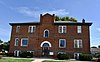
| 1 | Clarinda Carnegie Library |
 |
January 15, 2014 (#13001078) |
300 N. 16th St. 40°44′26″N 95°02′18″W / 40.740572°N 95.038301°W |
Clarinda | |
| 2 | Goldenrod Schoolhouse |
 |
September 23, 1994 (#75000697) |
1600 S. 16th St. 40°43′21″N 95°02′14″W / 40.7225°N 95.037222°W |
Clarinda | Originally listed in 1975, removed from Register in August 1993 when schoolhouse was relocated. Returned to Register September 23, 1994. |
| 3 | Col. William Peters Hepburn House |
 |
June 4, 1973 (#73000736) |
321 W. Lincoln St. 40°44′28″N 95°02′31″W / 40.741111°N 95.041944°W |
Clarinda | |
| 4 | Iowan’s Hotel |
 |
January 29, 2009 (#08001382) |
508 E. Railroad St. 40°51′55″N 94°59′09″W / 40.865278°N 94.985833°W |
Essex | |
| 5 | McCoy Polygonal Barn | June 30, 1986 (#86001469) |
Off U.S. Route 71 40°51′55″N 94°59′09″W / 40.865278°N 94.985833°W |
Hepburn | ||
| 6 | Page County Courthouse |
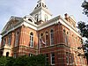 |
July 2, 1981 (#81000262) |
Main St. 40°44′12″N 95°02′13″W / 40.736667°N 95.036944°W |
Clarinda | |
| 7 | Wabash Combination Depot-Shenandoah |
|
September 6, 1990 (#90001298) |
Junction of Ferguson Rd. and Burlington Northern tracks 40°46′20″N 95°22′13″W / 40.772222°N 95.370278°W |
Shenandoah | |
| 8 | W.T.S. White House and Carriage House |
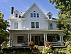 |
January 21, 1994 (#93001544) |
400 N. 16th St. 40°44′29″N 95°02′17″W / 40.741389°N 95.038056°W |
Clarinda | |
| 9 | Women’s Christian Temperance Union Public Fountain |
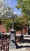 |
September 27, 1984 (#84001293) |
Clarinda and Sheridan Sts. 40°45′57″N 95°22′19″W / 40.765833°N 95.371944°W |
Shenandoah |
See also[edit]
References[edit]
- ^ The latitude and longitude information provided in this table was derived originally from the National Register Information System, which has been found to be fairly accurate for about 99% of listings. Some locations in this table may have been corrected to current GPS standards.
- ^ National Park Service, United States Department of the Interior, “National Register of Historic Places: Weekly List Actions”, retrieved March 31, 2023.
- ^ Numbers represent an alphabetical ordering by significant words. Various colorings, defined here, differentiate National Historic Landmarks and historic districts from other NRHP buildings, structures, sites or objects.
- ^ “National Register Information System”. National Register of Historic Places. National Park Service. July 9, 2010.
- ^ The eight-digit number below each date is the number assigned to each location in the National Register Information System database, which can be viewed by clicking the number.
Recent Comments