Outer Holm of Skaw – Wikipedia
From Wikipedia, the free encyclopedia
Coordinates:
60°23′21″N 0°54′20″W / 60.389079°N 0.905512°W
| Location | |
|---|---|

|
|
| Coordinates | 60°23′21″N 0°54′20″W / 60.389079°N 0.905512°W |
| Physical geography | |
| Island group | Shetland |
| Highest elevation | 14 feet (4.3 m)[1] |
| Administration | |
| Sovereign state | United Kingdom |
| Country | Scotland |
| Council area | Shetland Islands |
| Demographics | |
| Population | 0 |
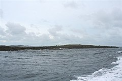
The Outer Holm of Skaw is a small, uninhabited islet, a rock outlier off the northeast coast of the island of Whalsay, in the Shetland Islands of Scotland.[2]
Location[edit]
The Outer Holm of Skaw is 14 feet (4.3 m) high, and is about 0.5 miles (0.80 km) to the north of Skaw Taing on the island of Whalsey. The 32 feet (9.8 m) high Inner Holm of Skaw lies between the Outer Holm of Skaw and Whalsey.[1]
Gallery[edit]

References[edit]
Citations
Sources
-
Munro, David M.; Gittings, Bruce M. (2006). Scotland: an encyclopedia of places & landscapes. Collins. p. 370. ISBN 978-0-00-472466-9. Retrieved 4 February 2013.
- United States. Hydrographic Office (1950). Sailing directions for the north and east coasts of Scotland: Cape Wrath to Fife Ness and including the Orkney, Shetland and Faeroe Islands. U.S. Govt. Print. Off. Retrieved 4 February 2013.
Our servers are currently under maintenance or experiencing a technical problem.
Please try again in a few minutes.
See the error message at the bottom of this page for more information.
Recent Comments