Pujon County – Wikipedia
From Wikipedia, the free encyclopedia
County in South Hamgyong Province, North Korea
|
Pujon County
부전군 |
|
|---|---|
| Korean transcription(s) | |
| • Hanja | 赴戰郡 |
| • McCune-Reischauer | Pujŏn kun |
| • Revised Romanization | Bujeon-gun |

In Pujŏn county |
|
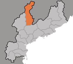 Map of South Hamgyong showing the location of Pujon |
|
| Country | North Korea |
| Province | South Hamgyong Province |
| Area | |
| • Total | 1,775 km2 (685 sq mi) |
| Population | |
| • Total | 48,351 |
| • Density | 27/km2 (71/sq mi) |
Pujŏn County (Pujŏn kun) is a city in northern South Hamgyŏng province, North Korea.
In historical contexts, Pujŏn is sometimes known as Fusen, according to its Japanese pronunciation.
The Korean People’s Revolutionary Army built a secret camp on Mount Okryon in Pujŏn in the 1930s. This area was home to revolutionary activities of Kim Jong-suk during the anti-Japanese struggle. Commemorating her activities the Pujŏn Revolutionary Battle Site has been designated.[2]
Administrative divisions[edit]
Pujŏn county is divided into 1 ŭp (town), 2 rodongjagu (workers’ districts) and 14 ri (villages):
|
|
Transportation[edit]
Pujŏn county is served by the Sinhŭng line of the Korean State Railway.
It has one of the three speed skating ovals in the country.[3]
References[edit]
- ^ North Korea: Administrative Division
- ^
“Pujon Revolutionary Battle Site of DPRK Introduced by ITAR-TASS”. KCNA. 7 August 2012. Archived from the original on 12 October 2014.
- ^ Rink card of: Stadion Pujon Bujeon (Pujon)
External links[edit]
| Capital |
 |
|
|---|---|---|
| Cities | ||
| Districts | ||
| Counties | ||
Coordinates:
40°29′N 127°37′E / 40.483°N 127.617°E
Recent Comments