Kikai Caldera – Wikipedia
From Wikipedia, the free encyclopedia
Mostly-submerged caldera in the Ōsumi Islands of Kagoshima Prefecture, Japan
| Kikai Caldera | |
|---|---|
 |
|
| Peak | Mount Iō (Iōjima), Iōjima, Ōsumi Islands, Japan |
| Elevation | 704 m (2,310 ft) |
| Coordinates | 30°47′N 130°19′E / 30.79°N 130.31°ECoordinates: 30°47′N 130°19′E / 30.79°N 130.31°E[1] |
| Length | 17 km (11 mi) NS |
| Width | 20 km (12 mi) EW |
| Native name | 鬼界カルデラ (Japanese) |
| Country | Japan |
| State | Kagoshima Prefecture |
| Region | Ōsumi Islands |
| District | Kagoshima District |
| Subdivisions | Mount Yahazu, Mount Iō (Iōjima), Mount Inamura (Iōjima), Iōjima, Shin Iōjima, Takeshima, Mount Nakasone, Mount Asase, Mount Shitakisone, Iō Tai and Takeshima Tai |
| Municipality | Mishima |
| Age of rock | 6,300 to 95,000 years ago |
Kikai Caldera (鬼界カルデラ, Kikai karudera) (alternatively Kikaiga-shima, Kikai Caldera Complex) is a massive, mostly submerged caldera up to 19 kilometres (12 mi) in diameter in the Ōsumi Islands of Kagoshima Prefecture, Japan.[2]
Geology[edit]
Caldera formation has been dated from about 95,000 years ago and has involved rhyolite, basalt, and andesite phases.[2] The Kikai Caldera Complex has twin ovoid caldera 20 km (12 mi) by 17 km (11 mi) in diameter.[2] Yahazu-dake (north west part of Satsuma Io-jima) and Takeshima, located on the caldera rim, are pre-caldera volcanoes.[2]
Kikai-Tozurahara eruption[edit]
This was about 95,000 years before the present and erupted Kikai-Tozurahara (K-Tz) tephra.[3] Various dating techniques give ages between 70,000 and 100,000 years before present.[4] This was distributed all over Japan but did not reach South Korea.[4]
Akahoya eruption[edit]
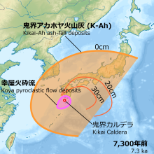
The caldera was the source of the Akahoya eruption, one of the largest eruptions during the Holocene (10,000 years ago to present) that produced the Kikai-Akahoya (K-Ah) tephra.[5] Between 7,200 and 7,300 years ago,[5][4][3]pyroclastic flows producing Koya ignimbrite from that eruption reached the coast of southern Kyūshū up to 100 km (62 mi) away, and ash fell as far as Hokkaidō. The eruption produced about 150 km³ of tephra,[6] giving it a Volcanic Explosivity Index of 7[7] and making it one of the most explosive in the last 10,000 years, ranking alongside the eruptions of Santorini, Paektu, Crater Lake, Kurile Lake, Samalas and Tambora.[8] According to ice cores, initially it was thought that the Akahoya eruption may have occurred in 4350 BC,[9] however this timing has later been adjusted to about 1000 years earlier.[5][3]
The eruption had a major impact on the Jōmon culture in southern Kyūshū although the impact was not as great as some commentary had suggested with Nishinozono sub-type pottery tradition, that had started prior to the eruption, maintained in Kyūshū.[10]
Eruptive history since Akahoya eruption[edit]
Kikai is still an active volcano. Io-dake(Mount Iō), Inamura-dake (south coast of Satsuma-Io-jima), Tokara-Iwo-Jima (north east coast of Satsuma-Io-jima) and Shōwa Iōjima (Shin-Io-jima) are post-caldera volcanoes within it.[2] Minor eruptions occur frequently on Mount Iō, one of the post-caldera subaerial volcanic peaks on Iōjima. Iōjima is one of three volcanic islands, two of which lie on the caldera rim. On June 4, 2013, weak tremors were recorded. Shortly after, eruptions began and continued off-and-on for several hours.[11]

Eruptions occurred:[2][12]
- old Iwo-dake stage (stage OIo-I-II)
- phreatomagmatic eruptions and pumice fallout (stage OIo-I), followed by rhyolitic lava with continuous tephra, resulting in a volcanic edifice (stage OIo-II)
- 3250 BCE ± 75 years (uncalibrated) Old Iwo-dake
- 2450 BCE ± 840 years (tephrochronology) Old Iwo-dake
- Inamura-dake stage (stage In-I-IV)
- basaltic lava flows and scoria-cone building (stage In-I-II), then phreatomagmatic eruptions (stage In-III), and then andesitic lava (stage In-IV)
- 1830 BCE ± 75 years (uncalibrated) Inamura-dake[6]
- 1090 BCE ± 100 years (uncalibrated) Inamura-dake[6]
- young Iwo-dake stage (stage YIo-I-IV)
- continuing with a different magma source including rhyolitic lava and intermittent pumice
- 280 BCE ± 75 years (uncalibrated) Iwo-dake[6]
- 390 ± 100 years (uncalibrated) Iwo-dake[6]
- 750 (tephrochronology) Iwo-dake[6]
- 830 ± 40 years (uncalibrated) Iwo-dake[6]
- 1010 ± 40 years (uncalibrated) Iwo-dake[6]
- 1030 ± 40 years (uncalibrated) Iwo-dake[6]
- 1340 ± 30 years (uncalibrated) Iwo-dake[6]
- 1430 ± 75 years (uncalibrated) Iwo-dake[6]
- 13 Feb 1914 Tokara-Iwo-Jima[6]
- Sep-Nov 1934
- Submarine eruption with pumice
- 7 Dec 1934 -Mar 1935 2 km east of Tokara-Iwo-Jima[2]
- 1997-2003 Iwo-dake[2]
- Formation and enlargement of new pit crater inside the summit crater
- Apr-Nov 1998 Iwo-dake[2]
- May-Aug 1999 Iwo-dake[2]
- Jan, Mar, Oct-Dec 2000 Iwo-dake[2]
- Feb, Apr-Dec 2001 Iwo-dake[2]
- May-Jul 2002 Iwo-dake[2]
- Feb, Apr-Oct 2003 Iwo-dake[2]
- May-Apr, Jun, Aug-Oct 2004 Iwo-dake[2]
- 3-5 May, 3-5 Jun 2013 Iwo-dake[2]
- 2 Nov 2019 Iwo-dake[2]
- 29 Apr 2020 Iwo-dake[2]
- 6 Oct 2020 Iwo-dake[2]
See also[edit]
Further reading[edit]
References[edit]
- ^ “Kikai | Volcano World | Oregon State University”. volcano.oregonstate.edu. 24 April 2011. Retrieved 2017-04-11.
- ^ a b c d e f g h i j k l m n o p q r s “Satsuma-iojima”. Geological Survey of Japan. Retrieved 2022-09-18.
- ^ a b c Smith, Victoria C.; Staff, Richard A.; Blockley, Simon P.E.; Ramsey, Christopher Bronk; Nakagawa, Takeshi; Mark, Darren F.; Takemura, Keiji; Danhara, Toru (2013). “Identification and correlation of visible tephras in the Lake Suigetsu SG06 sedimentary archive, Japan: chronostratigraphic markers for synchronising of east Asian/west Pacific palaeoclimatic records across the last 150 ka”. Quaternary Science Reviews. 67: 121–137. doi:10.1016/j.quascirev.2013.01.026. ISSN 0277-3791.
- ^ a b c Okuno, Mitsuru (2019-04-15). “Chronological study on widespread tephra and volcanic stratigraphy of the past 100,000 years”. The Journal of the Geological Society of Japan. 125 (1): 41–53. doi:10.5575/geosoc.2018.0069. ISSN 1349-9963. S2CID 146526393.
- ^ a b c Tsuji, Tomohiro; Ikeda, Michiharu; Furusawa, Akira; Nakamura, Chisato; Ichikawa, Kiyoshi; Yanagida, Makoto; Nishizaka, Naoki; Ohnishi, Kozo; Ohno, Yuki (2018). “High resolution record of Quaternary explosive volcanism recorded in fluvio-lacustrine sediments of the Uwa basin, southwest Japan”. Quaternary International. 471: 278–297. doi:10.1016/j.quaint.2017.10.016. ISSN 1040-6182.
- ^ a b c d e f g h i j k l m n Kikai – Eruptive history, Global Volcanism Program. Smithsonian Institution.
- ^ Johnston, Eric, “Latest volcano show: Shinmoe“, The Japan Times, 1 March 2011, p. 3.
- ^ “Large Volcano Explocivity Index”. Countries of the World. Retrieved 2014-04-24.
- ^ Zielinski, G. A.; Mayewski, P. A.; Meeker, L. D.; Whitlow, S.; Twickler, M. S.; Morrison, M.; Meese, D. A.; Gow, A. J.; Alley, R. B. (1994-05-13). “Record of Volcanism Since 7000 B.C. from the GISP2 Greenland Ice Core and Implications for the Volcano-Climate System”. Science. 264 (5161): 948–952. Bibcode:1994Sci…264..948Z. doi:10.1126/science.264.5161.948. ISSN 0036-8075. PMID 17830082. S2CID 21695750.
- ^ Junzo, Uchiyama (2021). “After a Super Volcanic Eruption: a new project on social-ecological impacts of the Kikai-Akahoya disaster, 7,300 years ago”. Retrieved 2022-09-18.
- ^ “Global Volcanism Program | Kikai”. volcano.si.edu. Retrieved 2017-04-07.
- ^ Maeno, Fukashi; Taniguchi, Hiromitsu (2005-05-20). “Eruptive History of Satsuma Iwo-jima Island, Kikai Caldera, after a 6.5 ka Caldera-forming Eruption”. 火山 (Volcano). 50: 71–85. doi:10.18940/kazan.50.2_71.
External links[edit]
Recent Comments