List of cemeteries in Boone County, Missouri

Name Image Location Type Description Antioch Cemetery Antioch Cemetery in Columbia, Missouri in may 2018.jpg Columbia
38°59′07″N 92°16′26″W / 38.985352°N 92.273878°W / 38.985352; -92.273878 Church 
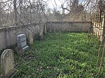
Antioch Cemetery is located on the north side of Mexico Gravel Road east of the Hinkson Creek bridge. Antioch Church was built here during the summer and fall of 1853. Prior to that the congregation was called Bear Creek Church and was located in a log cabin on the banks of Bear Creek.[6] At some point the congregation and church building ceased to exist. As of 2018 the cemetery is fenced and mowed, however, there are toppled and buried monuments. Ariel Cemetery My Ariel church cemetery tombstone.jpg Riggs area39°09′36″N 92°22′25″W / 39.159895°N 92.373485°W / 39.159895; -92.373485 Church Unusually, a single burial is all that remains of Ariel (pronounced “Errol”) Christian Church. Oscar Jacks, the son of one of Ariel’s founders. A frame church was dedicated in 1888 as the spiritual successor to nearby Mount Carmel Baptist Church, which closed in 1873. Ariel Church became defunct in 1934 and by 1942 the building was in poor shape. At some point the church burned. The ground was surveyed by the WPA in the 1930s. Many members are buried at Mount Carmel (Sims) Cemetery nearby.[7] Barnes Chapel Cemetery Barnes Chapel Cemetery on May 19th 2018.jpg Ginlet area38°51′42″N 92°10′24″W / 38.861571°N 92.173276°W / 38.861571; -92.173276 Church Located east of Barnes Chapel on Barnes Chapel Road, predictably this cemetery contains many Barnes among others. The church was established in 1896 according to the sign. Beth Olem Cemetery Beth Olem Cemetery on June 11th 2018.jpg Columbia38°56′54″N 92°20′06″W / 38.948389°N 92.335108°W / 38.948389; -92.335108 Jewish Beth Olem is the only Jewish Cemetery in Columbia. Founded in 1880 by the Columbia Hebrew Association, it became part of Columbia Cemetery in 1928. There are over one hundred burials. Bethel Cemetery Bethel church first in Boone county missouri.jpg Woodlandview area39°02′29″N 92°31′12″W / 39.041515°N 92.519914°W / 39.041515; -92.519914 Church This cemetery belonged to Bethel Baptist Church, now gone. It was the first church and cemetery in Boone County and is the oldest Baptist church in the state of Missouri. The land was once owned by a son of Daniel Boone. Founded in 1817, it is also known as “Old Bethel”.[8] Bethel Cemetery Bethel Cemetery (Boone County, Missouri).jpg Columbia38°53′32″N 92°20′40″W / 38.892283°N 92.344412°W / 38.892283; -92.344412 Church 
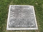
This Cemetery is located next to Bethel Baptist Church in south Columbia, Missouri. Founded in 1855, it is the younger of two Bethel Cemeteries in Boone County. The church and cemetery are still active and are currently affiliated with the American Baptist Convention. The Hickam Cemetery is located inside/adjacent to Bethel Cemetery. Bedford-Estes burials were moved here. Bethlehem Cemetery Bethlehem Cemetery on May 20th 2018.jpg Harrisburg area39°05′49″N 92°27′09″W / 39.09696°N 92.452507°W / 39.09696; -92.452507 Church Cemetery is located near the intersection of Callahan Creek Road and Bethlehem Road. The Church no longer stands. Bond’s Chapel Cemetery BondsChapel.jpg Hartsburg area38°42′34″N 92°17′07″W / 38.709484°N 92.285264°W / 38.709484; -92.285264 Church Next to Bond’s Chapel Methodist Episcopal Church. Only the church is listed on the National Register of Historic Places. The cemetery remains active. Botner Cemetery Botner Cemetery on December 26th 2018.jpg Hinton area39°04′48″N 92°22′55″W / 39.079905°N 92.381866°W / 39.079905; -92.381866 Family Located across the street from a home at 3200 W Botner Road. Grounds are fenced and the cemetery is owned and well-maintained by a Botner descendant. Boulton Cemetery Boulton Cemetery in Columbia, Missouri in September 2019.jpg Columbia38°59′49″N 92°18′17″W / 38.996808°N 92.304826°W / 38.996808; -92.304826 Family Also known as the Judge Jesse Boulton Farm Cemetery. At least four burials. Boyd Cemetery Boyd Cemetery on June 18th 2018.jpg Finger Lakes State Park39°05′22″N 92°19′27″W / 39.089551°N 92.324232°W / 39.089551; -92.324232 Family Located near the motocross area parking lot, the stones have been moved but a fence and sign mark the area Brink Cemetery Brink Family Cemetery on June 2nd 2018.jpg Sturgeon area39°13′10″N 92°17′44″W / 39.219565°N 92.295612°W / 39.219565; -92.295612 Family Very overgrown, at a bend in Lovers Lane southwest of Sturgeon. Bullard-Barger Cemetery Bullard-Barger Cemetery on June 16th 2018.jpg Englewood area38°49′02″N 92°10′31″W / 38.817172°N 92.175277°W / 38.817172; -92.175277 Family Located east of Englewood and north of Englewood Road, it is fenced and some stones have been cleaned. Cochran Cemetery Cohran Cemetery, Midway Area, Boone County, Missouri USA.jpg Midway area Family Located in a front yard Columbia Cemetery ColumbiaCemetery.JPG Columbia38°56′59″N 92°20′14″W / 38.94971°N 92.337347°W / 38.94971; -92.337347 Municipal Original cemetery for the city of Columbia. Placed on the National Register of Historic Places in 2007. Over time it has grown to include the bounds of two other formerly separate cemeteries. Notable burials include Blind Boone, James S. Rollins, William Franklin Switzler, Edwin William Stephens, and Jane Froman.[9] Conley Cemetery Conley Cemetery near McBain, Missouri on April 7 2019.jpg McBaine area38°53′18″N 92°26′10″W / 38.888401°N 92.436134°W / 38.888401; -92.436134 Family Seven Conley family member buried here. Gated and surrounded by a wall. Centralia Cemetery Centralia, Missouri Cemetery on May 11th 2018.jpg Centralia39°13′03″N 92°08′05″W / 39.217418°N 92.134856°W / 39.217418; -92.134856 Municipal Public cemetery owned by the city of Centralia. Located on Missouri Highway 22. Crews-Sims Cemetery Crews-Sims Cemetery on May 19th 2018.jpg Ginlet area38°53′19″N 92°10′06″W / 38.888708°N 92.168448°W / 38.888708; -92.168448 Family Just south of a right angle in Vemers Ford Road Dinwiddie Cemetery Dinwiddie Family Cemetery on Memorial Day 2018 from the Southwest.jpg Columbia38°56′06″N 92°15′08″W / 38.934956°N 92.252239°W / 38.934956; -92.252239 Family 
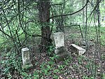
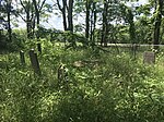
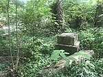
Dinwiddle Cemetery is located in a grove of trees near the fourth hole of Old Hawthorne Gold Course. Most markers are out of place and propped against trees. Several stones have birthdates in the 1700s. Dripping Springs Cemetery Dripping Springs Cemetery on May 11th 2018.jpg Hinton area39°05′13″N 92°22′30″W / 39.08692°N 92.374954°W / 39.08692; -92.374954 Church Cemetery for Dripping Springs Christian Church located in the community of Dripping Springs. Ellington Cemetery Ellington Cemetery on Memorial Day 2018.jpg Midway area38°58′27″N 92°29′19″W / 38.974197°N 92.488499°W / 38.974197; -92.488499 Family Very overgrown and derelict Cemetery, some headstones still standing in 2021, Located near I-70 on private property. Elmwood Cemetery Elmwood Cemetery in Columbia, Missouri on June 11th 2018.jpg Columbia38°57′02″N 92°20′16″W / 38.950484°N 92.337828°W / 38.950484; -92.337828 Established in 1914 next to the Columbia Common Burial Grounds and merged with the Columbia Cemetery two years later. Estes Cemetery Estes Cemetery on May 19th 2018.jpg Columbia38°55′45″N 92°16′03″W / 38.929234°N 92.267431°W / 38.929234; -92.267431 Family As of 2018 cemetery stands in a grove of trees, abandoned, surrounded by residential development Estes-Bedford Cemetery Bedford-Estes Cemetery on June 3rd 2018.jpg Columbia38°53′34″N 92°20′42″W / 38.892772°N 92.344979°W / 38.892772; -92.344979 Family Was located near Bethel Road close by Gentry Middle School. 16 graves moved to Bethel-Hickam. Evans Cemetery Evans Cemetery on June 18th 2018.jpg Rucker area39°14′13″N 92°25′00″W / 39.236825°N 92.416551°W / 39.236825; -92.416551 Family Located in a grove of old ceder trees on a farm north of Rucker. Many field-stones are visible indicating at least six burials. No dressed stones were visible as of 2018. Everett Cemetery Everett Cemetery on December 15th 2018.jpg Woodlandville area39°03′41″N 92°27′48″W / 39.061324°N 92.463298°W / 39.061324; -92.463298 Church About one mile east of Woodlandville, Everett Church (Methodist South) was established in 1859. A descendant of Daniel Boone is buried here. Far West Cemetery Far West Cemetery on June 2nd 2018.jpg Sturgeon area39°11′54″N 92°14′21″W / 39.198309°N 92.239095°W / 39.198309; -92.239095 Located on Barns Road southeast of Sturgeon. Fairview Cemetery Fairview cemetery como.jpg Columbia38°56′09″N 92°22′49″W / 38.935904°N 92.380188°W / 38.935904; -92.380188 Church At the intersection of Chapel Hill and Fairview roads behind an old church now used as a daycare. Forbis Cemetery Forbis Cemetery on June 3rd 2018.jpg Ashland area38°47′05″N 92°17′55″W / 38.784613°N 92.298747°W / 38.784613; -92.298747 Family Located on the east side of State Highway MM Fortney Cemetery Fortney Cemetery on June 11th 2018.jpg Columbia area38°52′43″N 92°18′51″W / 38.878679°N 92.314191°W / 38.878679; -92.314191 Family Located on farmland north of Rock Bridge State Park Fountain Cemetery Fountain Cemetery 1 on January 4th 2019.jpg Centralia area39°11′46″N 92°12′43″W / 39.196237°N 92.211923°W / 39.196237; -92.211923 Family Located northwest of Tri-City Lake and abandoned in the woods. There are several large toppled granite markers and many Yucca plants, potentially marking many graves. Area appears fairly large for a family cemetery. Friedens Evangelical Cemetery Frieden's Cemetery on June 3rd 2018.jpg Hartsburg38°41′55″N 92°18′32″W / 38.698669°N 92.309016°W / 38.698669; -92.309016 Church, German Just outside of the city limits of Hartsburg, Missouri. Associated with Friendens Evangelical Church Friendship Cemetery Friendship Church Cemetery on May 11th 2018.jpg Hallsville area39°05′53″N 92°17′24″W / 39.097922°N 92.289898°W / 39.097922; -92.289898 Church Friendship Church still stands unused next to this cemetery. Glendale Memorial Cemetery Glendale Memorial Cemetery on May 11 2018.jpg Centralia39°13′11″N 92°08′04″W / 39.219845°N 92.134494°W / 39.219845; -92.134494 Modern Located across highway 22 from Centralia Cemetery and recently created. German Cemetery German Family Cemetery on May 11th.jpg Centralia area39°08′32″N 92°06′44″W / 39.142175°N 92.112339°W / 39.142175; -92.112339 Family Small family cemetery, fenced, next to the road. Goodin Cemetery Goodin Cemetery in Spring 2018.jpg Columbia38°56′27″N 92°24′10″W / 38.940713°N 92.402642°W / 38.940713; -92.402642 Family Located in the Georgetown Subdivision near Goodin Branch Creek. Named after the family buried within. Goshen Cemetery Goshen Cemetery on June 11th 2018.jpg Wilton38°44′05″N 92°21′17″W / 38.734621°N 92.354624°W / 38.734621; -92.354624 Church Across the street from Goshen Primitive Baptist Church on the bluff above Wilton, Missouri. Grandview Cemetery Grandview Church Cemetery on June 2nd 2018.jpg Two-Mile Prairie39°02′39″N 92°10′01″W / 39.044237°N 92.166947°W / 39.044237; -92.166947 Church Standing next to the Grandview Missionary Baptist Church on route Z, this cemetery is on the Two-Mile Prairie. Green Acres Cemetery Green Acres natural burial cemetery in Boone County, Missouri .jpg Columbia area38°56′45″N 92°28′25″W / 38.945805°N 92.473501°W / 38.945805; -92.473501 Natural According to KOMU-TV Green Acres Natural Burial Cemetery is the only “green’ burial in the state.[10] It is across the road from Sugar Creek Cemetery. Hallsville Church of Christ Cemetery Hallsville Church of Christ Cemetery on May 11th 2018.jpg Hallsville39°07′06″N 92°14′38″W / 39.118402°N 92.243755°W / 39.118402; -92.243755 Church Around the corner from Red Top Christian Church on Missouri Highways 124 Hamilton Cemetery Hamilton Family Cemetery on May 2nd 2018.jpg Shaw area38°56′54″N 92°11′14″W / 38.948345°N 92.187319°W / 38.948345; -92.187319 Family Sign near the front gate says “E.A. Hamilton Family Cemetery Boone County Court Trustee” Hatton Chapel Cemetery Hatton Chapel in Boone County, Missouri.jpg Columbia area39°00′56″N 92°24′53″W / 39.015543°N 92.414697°W / 39.015543; -92.414697 Church There is one unmarked infant burial from around 1910 at the northeast corner of the church. It is located on Hatton Chapel Road in western Boone County. Harris Cemetery Harris Family Cemetery in Boone County, Missouri.jpg Deer Park area38°51′20″N 92°15′02″W / 38.855655°N 92.250478°W / 38.855655; -92.250478 Family Family cemetery on what was formerly a large plantation, now surrounded by thick concrete wall. Several families buried within but most prominently the Harris’ Harrisburg Cemetery Harrisburg, Missouri Cemetery on May 20th.jpg Harrisburg39°08′29″N 92°27′20″W / 39.141449°N 92.455632°W / 39.141449; -92.455632 Municipal This is the public cemetery for town of Harrisburg, Missouri. Located near the east entrance to town at the junction of Route F and Missouri Highway 124. Henry Cemetery Henry Family Cemetery on June 2nd 2018.jpg Columbia39°00′41″N 92°16′05″W / 39.011262°N 92.267943°W / 39.011262; -92.267943 Family Cemetery was preserved and marked in the parking lot of Columbia Foods. Also known as the Keene Cemetery. Hickam Cemetery Hickam Cemetery in Bethel Cemetery (Boone County, Missouri).jpg Columbia38°53′31″N 92°20′42″W / 38.891993°N 92.344897°W / 38.891993; -92.344897 Family Hickam Family burials located in/adjacent to Bethel Cemetery in south Columbia, Missouri. A Separate fence and gate, with the name Hickam above, frame the cemetery. Hicks Cemetery Hicks Cemetery on June 3rd 2018.jpg Hallsville area39°06′47″N 92°18′56″W / 39.113038°N 92.315566°W / 39.113038; -92.315566 Family Family cemetery on the homestead founded by Absalom Hicks in the 1820s. Probable burial of one of Boone County’s first Commissioners who, along with four others selected Columbia as the county seat. Hinkson Creek Cemetery Big Tree at Hinkson Creek Cemetery in Boone County, Mo.jpg Columbia38°58′49″N 92°16′30″W / 38.980262°N 92.275093°W / 38.980262; -92.275093 Church Located in the bluffs above the Hinkson Creek Valley in northeast Columbia. Has also been called the Old Hinkson Baptist Cemetery. It is now overgrown and abandoned. Jewell Cemetery State Historic Site Jewell Cemetery.JPG Columbia38°55′11″N 92°20′10″W / 38.919722°N 92.336111°W / 38.919722; -92.336111 Family, State Historic Site Created by George Jewell for his decedents. Now a Missouri State Historic Site. It was placed on the National Register of Historic Places in 1970.[11] Burial place of William Jewell and Charles Henry Hardin. Johnson Cemetery Johnson Cemetery on Memorial Day.jpg Englewood area38°49′39″N 92°09′25″W / 38.827519°N 92.156991°W / 38.827519; -92.156991 Family Very large family cemetery located on Johnson Cemetery Road in far eastern Boone County. Extremely well maintained. A huge grove of ceders stands in the oldest part. Jones-Little Cemetery Jones-Little Cemetery on June 14th 2018.jpg Pierpont area38°51′27″N 92°20′54″W / 38.857463°N 92.348397°W / 38.857463; -92.348397 Family Cemetery is northeast of the intersection of High Point Lane and Hill Creek Road. Markers with death dates as early as 1839 still standing. At least a dozen burials maybe more. Also called Jones-Little-Hopper Lemon Cemetery Lemon Family Cemetery on June 15th 2018.jpg Columbia area38°59′52″N 92°20′54″W / 38.997653°N 92.348435°W / 38.997653; -92.348435 Family At least seven burials. Also called the Creasy Springs Road Burial Ground. Lick Fork Cemetery Lick Creek Cemetery on June 2nd 2018.jpg Sturgeon area39°12′50″N 92°20′59″W / 39.213929°N 92.349692°W / 39.213929; -92.349692 Church Cemetery is on Ponderosa Road. Church building no longer stands. Lientz Cemetery Lientz Cemetery on Memorial Day 2018.jpg Rocheport area39°00′29″N 92°30′19″W / 39.008162°N 92.505271°W / 39.008162; -92.505271 Family This is the Lientz family cemetery located on Walnut Grove Road. A sign says it was restored in 1990. At that time a marker was placed for one of the first Curators of the University of Missouri. As of 2018 Cemetery is overgrown but stones appear standing. Little Bethel Cemetery Little Bethel Cemetery on Memorial Day 2018.jpg Midway area38°58′53″N 92°28′38″W / 38.981289°N 92.477252°W / 38.981289; -92.477252 Family Also called the Rice Family Cemetery, it is located west of Midway. Little Bonne Femme Cemetery Bonne Femme Baptist Church Cemetery in Boone County, Missouri.jpg Deer Park area38°52′40″N 92°15′29″W / 38.877847°N 92.257932°W / 38.877847; -92.257932 Church Next to the Little Bonne Femme Baptist Church, founded in 1819. Woolfolk cemetery markers were moved here. Locust Grove Cemetery Locust Grove cemetery in Boone County, Missouri.jpg Midway area38°59′09″N 92°26′52″W / 38.985898°N 92.447644°W / 38.985898; -92.447644 Church Cemetery is next to Locust Grove Methodist Church. Contains at least one American Revolutionary War soldier. Locust Grove Cemetery Loucust Grove Church Cemetery on May 3rd 2018.jpg Riggs area39°10′13″N 92°19′09″W / 39.170207°N 92.319038°W / 39.170207; -92.319038 Church Cemetery is on the grounds of the Locust Grove Baptist Church. Log Providence Cemetery Log Providence Church Cemetery in Boone County, Missouri.jpg Deer Park area38°50′25″N 92°16′28″W / 38.840295°N 92.274401°W / 38.840295; -92.274401 Church, African-American Located next to Log Providence Baptist Church, a historic African-American Church in the Three Creeks Area between Columbia and Ashland. McKimpson-McIntyre Cemetery McKimpson-McIntyre Cemetery on May 9th 2018.jpg Columbia38°57′10″N 92°16′37″W / 38.952752°N 92.276974°W / 38.952752; -92.276974 Family Once on the McIntyre(McIntire) Farm, what’s left is now in the woods behind Rebel Hill Trailer Park. In May 2018 no visible headstones remain, although two bases and a fieldstone marked 1865 were uncovered along with visible depressions. March Cemetery March Cemetery on June 18th 2018.jpg Harrisburg area39°07′33″N 92°27′07″W / 39.125779°N 92.451852°W / 39.125779; -92.451852 Family Located in an orchard, at least three stones present and readable as of 2018. Memorial Park Cemetery Memorial Park Cemetery in Columbia, Missouri at dusk.jpg Columbia38°58′07″N 92°21′18″W / 38.968747°N 92.354882°W / 38.968747; -92.354882 Modern Largest cemetery in Boone County. Burial place of Bud Walton. Mt. Celestial Cemetery Mt. Celestial Baptist Church, McBain.jpg McBaine area38°52′34″N 92°25′11″W / 38.876164°N 92.419612°W / 38.876164; -92.419612 Church, African-American African-American cemetery and church. Steepest cemetery in Boone County. Semi-Abandoned Mt. Hope Cemetery Mt. Hope Cemetery on June 2nd 2018.jpg Columbia area39°01′20″N 92°13′53″W / 39.022252°N 92.231257°W / 39.022252; -92.231257 Church, African-American African-American cemetery, church was torn down and the congregation moved to Columbia. Parts of the cemetery are overgrown in 2018. Mt. Horeb Cemetery Mount Horeb Cemetery sign on May 3rd 2018.jpg Sturgeon area39°12′57″N 92°17′03″W / 39.215836°N 92.28411°W / 39.215836; -92.28411 Church Used largely by the residents of Sturgeon and vicinity. Located South of the town on VV. Mt. Nebo Cemetery Mt. Nebo Cemetery in Boone County, Missouri.jpg Huntsdale area38°55′25″N 92°27′41″W / 38.923703°N 92.461376°W / 38.923703; -92.461376 Church Located on Mt. Nebo Church Road Mt. Pleasant Cemetery Mt. Pleasant Baptist Church Cemetery on May 10th 2018.jpg Claysville area38°41′25″N 92°15′28″W / 38.690207°N 92.257871°W / 38.690207; -92.257871 Church Located on Mt. Pleasant Road in southern Boone County. Mt. Zion Cemetery Mt. Zion Church west.jpeg Hallsville area39°04′10″N 92°10′46″W / 39.069376°N 92.179531°W / 39.069376; -92.179531 Church In the vicinity of the church and cemetery was the Civil War Battle of Mount Zion Church. The church and cemetery were placed on the National Register of Historic Places in 2013. Reportedly the highest point in Boone County. Nashville Cemetery Nashville Church Cemetery on June 3rd 2018.jpg Easley area38°49′27″N 92°21′00″W / 38.82424°N 92.350052°W / 38.82424; -92.350052 Church Located on Nashville Church road and across the street from the church. This is the community of Nashville, Missouri. Naylor-Schooling Cemetery Naylor Cemetery near Riggs, Missouri.jpg Riggs area39°09′33″N 92°20′10″W / 39.159087°N 92.336128°W / 39.159087; -92.336128 Family, Native America/Cherokee Also known as Naylor Cherokee Burial Grounds New Liberty Cemetery New Liberty Church Cemetery on June 3rd.jpg Ashland area38°46′08″N 92°16′52″W / 38.768798°N 92.281179°W / 38.768798; -92.281179 Church Large cemetery located across the road from New Liberty Church. New Providence Cemetery New Providence Cemetery on May 20th 2018.jpg Columbia area39°00′26″N 92°24′07″W / 39.007254°N 92.402052°W / 39.007254; -92.402052 Church Cemetery located next to New Providence Baptist Church. New Salem Cemetery New Salem Baptist Church Cemetery on May 10th 2018.jpg Ashland area38°47′59″N 92°15′10″W / 38.799603°N 92.252718°W / 38.799603; -92.252718 Church Large cemetery just off U.S. 63 south of Ashland. Surrounds New Salem Baptist Church. Oakland Cemetery Oakland Church Cemetery on June 2nd 2018.jpg Prathersville area39°01′48″N 92°17′36″W / 39.029977°N 92.293353°W / 39.029977; -92.293353 Church This is the cemetery of Oakland Christian Church, which was established in 1872. It is located on Oakland Church Road. Oakland Cemetery Oakland Methodist Episcopal Church Cemetery on June 3rd 2018.jpg Easley area38°49′06″N 92°18′27″W / 38.818364°N 92.307559°W / 38.818364; -92.307559 Church This is the cemetery of Oakland Methodist Episcopal Christian Church Old Gilead Cemetery Old Gilead Cemetery on June 2nd 2018.jpg Hallsville area39°04′38″N 92°16′52″W / 39.077131°N 92.280991°W / 39.077131; -92.280991 Church Cemetery is located down an abandoned road deep in the woods. Olivet Cemetery Olivet cemetery in Harg, Missouri.jpg Harg38°55′37″N 92°13′47″W / 38.927005°N 92.229752°W / 38.927005; -92.229752 Church Associated with Olivet Christian Church, it is located at the intersection of WW with Olivet Road. O’Rear Cemetery Allen O’Rear Cemetery in Columbia, Missouri’.jpg Columbia area39°00′01″N 92°17′35″W / 39.000287°N 92.293039°W / 39.000287; -92.293039 Family 
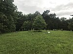
Cemetery moved from original location under the racetrack of the Boone County Fairgrounds. As of 2018 the area was fenced but no signs are markers were visible. Palmer Cemetery Lancelot Palmer Family Cemetery on June 2nd 2018.jpg Sturgeon area39°11′30″N 92°16′20″W / 39.191596°N 92.272279°W / 39.191596; -92.272279 Family Small family plot laid out by Lancelot Palmer stand at the crest of a hill in a cow pasture. Large obelisk and several other markers in various states of repair. Probably less than 10 burials. Perche Creek Cemetery Perche Cemetery in Boone County, Missouri from the east.jpg Rucker area39°11′56″N 92°25′23″W / 39.198814°N 92.423134°W / 39.198814; -92.423134 Church Located on Perche Creek next to Perche Creek Baptist Church. Prairie Grove Baptist Prairie Grove Baptist Church Cemetery on May 2nd 2018.jpg Shaw38°58′27″N 92°12′11″W / 38.974254°N 92.203183°W / 38.974254; -92.203183 Church Shaw is on the outskirts of Columbia. There are two cemeteries near the Shaw roundabout. This one was affiliated was Prairie Grove Baptist. Prairie Grove Methodist Shaw Methodist Church Cemetery on May 2nd 2018.jpg Shaw38°58′22″N 92°12′11″W / 38.972845°N 92.202976°W / 38.972845; -92.202976 Church Shaw is on the outskirts of Columbia. There are two cemeteries near the Shaw roundabout. This one was affiliated was Prairie Grove Methodist. Prewitt Cemetery Prewitt Cemetery on May 20th 2018.jpg Harrisburg39°08′27″N 92°27′54″W / 39.140747°N 92.464953°W / 39.140747; -92.464953 Family 
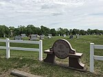
Prewitt Cemetery contains about eight burials. It is located west and behind of Harrisburg Elementary School. As of 2018 the Cemetery is fenced and mowed. Red Rock Cemetery Red rock Church cemetery in Boone County Missouri.jpg Perche area39°06′22″N 92°24′06″W / 39.106014°N 92.401602°W / 39.106014; -92.401602 Church Cemetery next to Red Rock Methodist Church Red Top Cemetery Red Top Church and Cemetery on May 11 2018.jpg Hallsville39°07′12″N 92°14′31″W / 39.120104°N 92.241911°W / 39.120104; -92.241911 Church This rather large and old cemetery is just west of Hallsville and next to Red Top Christian Church. The church was founded in 1822. Many old markers standing and repaired. Ridgeway Farm Cemetery Ridgeway Family Cemetery Marker on June 15th 2018.jpg Columbia38°57′33″N 92°18′06″W / 38.959052°N 92.301664°W / 38.959052; -92.301664 Family Headstones are gone. A marker was placed by the Ridgeway family on the Columbia Country Club Golf Course marking the location. Riggs Union Cemetery Riggs Union Church and Cemetery from the southeast.jpg Riggs39°10′18″N 92°20′46″W / 39.171771°N 92.346151°W / 39.171771; -92.346151 Church Established in Riggs next to Riggs Union Church. Today an active United Methodist Church. Rocheport Cemetery Rocheport cemetery Boone county Missouri.jpg Rocheport38°58′51″N 92°33′32″W / 38.98084°N 92.55898°W / 38.98084; -92.55898 Municipal On the hill just southeast of Rocheport is a very old and large city cemetery. Rock Bridge Cemetery Rock Bridge Cemetery on June 3rd 2018.jpg Pierpont38°52′08″N 92°18′01″W / 38.868983°N 92.30026°W / 38.868983; -92.30026 African-American Located next to Rock Bridge Memorial State Park, this cemetery is predominantly African-American. Rocky Fork Cemetery Rocky Fork Cemetery on May 11th 2018.jpg Hinton39°03′13″N 92°20′28″W / 39.053528°N 92.340992°W / 39.053528; -92.340992 Church Rocky Fork Cemetery stands next to Rocky Fork Baptist Church. It is named after Rocky Fork Creek Searcy Cemetery Searcy Cemetery in June 18th 2018.jpg Hinton area39°04′47″N 92°21′20″W / 39.079675°N 92.355488°W / 39.079675; -92.355488 Family At least four burials, including John Connelly, a veteran of the American Revolutionary War. Sims Cemetery Sim Cemetery near Riggs, Missouri..jpg Riggs area39°09′47″N 92°21′56″W / 39.16292°N 92.36553°W / 39.16292; -92.36553 Family and Church Established on the homestead of Abram Sims. Also known as Mt. Carmel, the name of the Church. Spence Cemetery Spence Family Cemetery in June 2nd 2018.jpg Columbia38°59′18″N 92°18′01″W / 38.988358°N 92.300413°W / 38.988358; -92.300413 Family Located in North Columbia on Wayside Drive. Also known as the Old Spence Burial Grounds Sprinkle Cemetery Sprinkle Cemetery on May 2nd 2018.jpg Columbia38°55′56″N 92°23′08″W / 38.932121°N 92.385474°W / 38.932121; -92.385474 Family Located at 1907 Chapel Ridge Road in the front of a residence. Fenced. Sturgeon Cemetery Sturgeon City Cemetery on May 7th 2018.jpg Sturgeon39°13′59″N 92°17′38″W / 39.233134°N 92.293782°W / 39.233134; -92.293782 Municipal Cemetery for the city of Sturgeon, Missouri, located west of the city. Sugar Creek Cemetery Sugar Creek Cemetery in west Boone County, Missouri on 9-19-17.jpg Columbia area38°56′44″N 92°28′19″W / 38.945459°N 92.471854°W / 38.945459; -92.471854 Church This cemetery is located on Hickory School Road, there was formerly a church associated, now no longer present. Tuttle Cemetery Tuttle Cemetery on June 3rd 2018.jpg Columbia38°54′09″N 92°22′54″W / 38.902556°N 92.381733°W / 38.902556; -92.381733 Family Located in extreme Southwest Columbia. At least six burials Union Cemetery South Union Church Cemetery (Boone County, MIssouri).jpg Columbia38°52′43″N 92°22′59″W / 38.878575°N 92.383052°W / 38.878575; -92.383052 Church This Cemetery is located at a bend in Sinclair Road near Arrowhead Lake. Also known as “Old Union” and “Union South” the church was established in 1822. Not to be confused with several other Union Cemeteries in Boone County. Union Cemetery Union Church (North) Cemetery on May 11th 2018.jpg Centralia area39°10′31″N 92°09′49″W / 39.175362°N 92.163722°W / 39.175362; -92.163722 Church On Union Church Road. The Church is no longer standing. Valley Springs Cemetery Valley Springs Cemetery on Memorial Day 2018.jpg Columbia area38°56′55″N 92°26′34″W / 38.948504°N 92.442757°W / 38.948504; -92.442757 Church Located just east of Route UU south of Midway. Wade-Shock Cemetery Wade-Shock Cemetery on June 15th 2018.jpg Columbia area39°01′06″N 92°22′07″W / 39.018471°N 92.368558°W / 39.018471; -92.368558 Family Also called the Sycamore Hills Cemetery or just the Wade Cemetery. Located in the backyard of a house at the northwest corner of the intersection of Fenton and Sycamore Hills Road. Some markers have been moved, buried, or lost. Waltnut Grove Cemetery Walnut grove cemetery Boone county mo.jpg Rocheport area39°00′46″N 92°31′24″W / 39.012777°N 92.523267°W / 39.012777; -92.523267 Church On the grounds of the former Walnut Missionary Baptist Church. There are an unusual amount of old standing markers. Woodcrest Cemetery Woodcrest Church Cemetery on June 3rd.jpg Ashland38°46′15″N 92°15′32″W / 38.770737°N 92.258884°W / 38.770737; -92.258884 Church On Henry Clay Boulevard in south Ashland. Woolfolk Cemetery Woolfolk Cemetery (relocated) at Bonne Femme in Boone County, Missouri.jpg Deer Park area38°52′41″N 92°15′27″W / 38.878176°N 92.257458°W / 38.878176; -92.257458 Family (original), Church (relocated) This cemetery was originally located northeast of Deer Park. Four headstones and four footstones were moved to Little Bonne Femme Cemetery, including the marker for John Woolfolk, a soldier of the American Revolution.