Lurøy – Wikipedia
From Wikipedia, the free encyclopedia
Municipality in Nordland, Norway
Municipality in Nordland, Norway
Lurøy is a municipality in Nordland county, Norway. It is part of the Helgeland traditional region. The administrative centre of the municipality is the village of Lurøy, located on the island of Lurøya. Other villages in Lurøy include Aldra, Haugland, Konsvikosen, Lovund, Sleneset / Solværøyene, Stokkvågen, and Tonnes.
The municipality is located on the coast just south of the Arctic circle, on the western edge of the Saltfjellet mountain range. The Lurøygården (Lurøy Farm) on the island of Lurøya is a more-than-200-year-old renaissance garden with old plants, a pool, and a nearly 20-metre (66 ft) high Copper Beech.
The 265-square-kilometre (102 sq mi) municipality is the 275th largest by area out of the 356 municipalities in Norway. Lurøy is the 286th most populous municipality in Norway with a population of 1,869. The municipality’s population density is 7.2 inhabitants per square kilometre (19/sq mi) and its population has decreased by 3.5% over the previous 10-year period.[3][4]
General information[edit]
Lurøy was established as a municipality on 1 January 1838 (see formannskapsdistrikt law). On 1 January 1872, the far western island district (population: 289) was separated from Lurøy to become the new municipality of Træna. This left Lurøy with 1,554 residents. The borders of Lurøy have not changed since that time.[5]
Name[edit]
The municipality (originally the parish) is named after the island of Lurøya (Old Norse: Lúðrøy) since the first Lurøy Church was built there. The first element is lúðr which means “hollowed log” (here probably referring to the form of the mountain of the island). The last element is øy which means “island”. Historically, the name was spelled Lurø.[6]
Coat of arms[edit]
The coat of arms was granted on 22 August 1986. The official blazon is “Or, a navigation cairn sable” (Norwegian: I gull en svart sjøvarde). This means the arms have a field (background) that has a tincture of Or which means it is commonly colored yellow, but if it is made out of metal, then gold is used. The charge is black navigational cairn. This was chosen to symbolize the local dependence on fishing and sailing in this island municipality. The arms were designed by Olga Nilsen after a proposal by Dagmar Vilfridadottir Olaisen.[7][8][9]
Churches[edit]
The Church of Norway has two parishes (sokn) within the municipality of Lurøy. It is part of the Nord-Helgeland prosti (deanery) in the Diocese of Sør-Hålogaland.
Geography and climate[edit]
Lurøy is located on the western coast of Helgeland. The small strip of mainland Lurøy runs from Tonnes in the north along Norwegian County Road 17 to Stokkvågen along the Sjona fjord in the south. The rest of the municipality is located on 1,375 islands located to the west of the mainland. The major islands include Aldra, Lurøya, Onøya, Stigen, Solvær, and Lovund. There are also two islands in the northern part of Lurøya that are divided between Lurøy and neighboring Rødøy Municipality: Nesøya and Hestmona.[10]
The populated islands are reached by car ferry from Stokkvågen on the mainland. The ferry reaches Onøy (which has a bridge to Lurøya), Solvær and Lovund 5 times per day.
Climate[edit]
Norwegian Meteorological Institute has operated weather stations on Solvær islands since 1939. Data shows a marine west coast climate (oceanic climate) with very mild winters for the high latitude. Spring and summer are the driest seasons, while December is the wettest month. The all-time high was recorded in July 2018, and the all-time low is from February 1966. The average date for the last overnight freeze (low below 0 °C (32.0 °F)) in spring is 20 April[11] and average date for first freeze in autumn is 5 November[12] giving a frost-free season of 198 days (1981-2010 average for Solvær).
| Climate data for Solvær 1991-2020 (10 m, precipitation days 1961-90, extremes 1954-2022) | |||||||||||||
|---|---|---|---|---|---|---|---|---|---|---|---|---|---|
| Month | Jan | Feb | Mar | Apr | May | Jun | Jul | Aug | Sep | Oct | Nov | Dec | Year |
| Record high °C (°F) | 10.6 (51.1) |
9.4 (48.9) |
10.5 (50.9) |
17.5 (63.5) |
25.5 (77.9) |
29.1 (84.4) |
30.7 (87.3) |
28 (82) |
23.2 (73.8) |
19.1 (66.4) |
15.1 (59.2) |
10.1 (50.2) |
30.7 (87.3) |
| Daily mean °C (°F) | 1.2 (34.2) |
0.6 (33.1) |
1.5 (34.7) |
4.3 (39.7) |
7.5 (45.5) |
10.7 (51.3) |
13.2 (55.8) |
13.4 (56.1) |
11 (52) |
7.1 (44.8) |
4.2 (39.6) |
2.4 (36.3) |
6.4 (43.6) |
| Record low °C (°F) | −14.5 (5.9) |
−16 (3) |
−10.2 (13.6) |
−6.4 (20.5) |
−2.5 (27.5) |
0.3 (32.5) |
4.4 (39.9) |
3.9 (39.0) |
0.5 (32.9) |
−5.2 (22.6) |
−8 (18) |
−13.5 (7.7) |
−16 (3) |
| Average precipitation mm (inches) | 119 (4.7) |
107 (4.2) |
94 (3.7) |
71 (2.8) |
78 (3.1) |
69 (2.7) |
86 (3.4) |
101 (4.0) |
132 (5.2) |
115 (4.5) |
117 (4.6) |
142 (5.6) |
1,231 (48.5) |
| Average precipitation days (≥ 1.0 mm) | 16 | 14 | 14 | 13 | 11 | 11 | 14 | 14 | 18 | 20 | 17 | 18 | 180 |
| Source: Norwegian Meteorological Institute[13] | |||||||||||||
Government[edit]
All municipalities in Norway, including Lurøy, are responsible for primary education (through 10th grade), outpatient health services, senior citizen services, unemployment and other social services, zoning, economic development, and municipal roads. The municipality is governed by a municipal council of elected representatives, which in turn elect a mayor.[14] The municipality falls under the Rana District Court and the Hålogaland Court of Appeal.
Municipal council[edit]
The municipal council (Kommunestyre) of Lurøy is made up of 19 representatives that are elected to four year terms. The party breakdown of the council is as follows:
| Party Name (in Norwegian) | Number of representatives |
|
|---|---|---|
| Local List(s) (Lokale lister) | 21 | |
| Total number of members: | 21 | |
Mayors[edit]
The mayors of Lurøy:[33]
- 1837-1840: Christian Eilert Rasch
- 1840-1845: Daniel Strøm Dundas
- 1846-1850: Carl Nicolai Bugge
- 1850-1854: Benjamin Olsen
- 1854-1860: Jeremias Willichsen
- 1860-1864: John Erik Steffensen
- 1865-1865: Paul Christian Føyn
- 1865-1866: Jens Christian Pettersen Tønder
- 1867-1869: John Erik Steffensen
- 1869-1870: Cornelius Eitran
- 1871-1875: Iver Olsen Riise
- 1875-1881: Knut Hansen
- 1881-1884: Anders Knutsen
- 1885-1886: Laurits Torgersen
- 1886-1886: Martin Israelsen
- 1887-1896: Mathias Knutsen
- 1896-1922: Isak Dundas
- 1922-1941: Jakob Victor Hansen
- 1941-1943: Fredrik Thorstein Krüger
- 1943-1945: Peder Larsen
- 1945-1947: Aubert Jentoft
- 1947-1961: Torvald Brandser
- 1961-1963: Ivar Riise
- 1963-1971: Torleif Hansen
- 1971-1973: Per Rise
- 1973-1975: Egil Fjellgård
- 1975-1978: Nils Nermark
- 1979-1988: Johannes Bentzen (Sp)
- 1988-2007: Steinar A. Joakimsen (Ap)
- 2007-2011: Carl Einar Isachsen, Jr. (Sp)
- 2011-2015: Bjørnar Skjæran (Ap)
- 2015-2019: Carl Einar Isachsen, Jr. (Sp)
- 2019-present: Håkon Lund (H)
Media gallery[edit]
-

Aldersundet strait and Aldra island; October 8, 2005
-

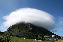
The island Lovund with its puffin colony is located in Lurøy
-

Aldersundet, October 2005
Notable people[edit]
- Harry Johan Olai Klippenvåg (1913 in Lurøy – 1994) a Norwegian politician, Mayor of Sør-Varanger in 1940’s & 50’s
- Herluf Nygaard (1916 in Lurøy – 2001) a Norwegian military officer, active resistance fighter during WWII
References[edit]
External links[edit]
Recent Comments