Palanan – Wikipedia
Municipality in Isabela, Philippines
Municipality in Cagayan Valley, Philippines
Palanan, officially the Municipality of Palanan (Ibanag: Ili nat Palanan; Ilocano: Ili ti Palanan; Tagalog: Bayan ng Palanan), is a 1st class municipality in the province of Isabela, Philippines. It also served as the final capital of the First Philippine Republic from 1900 until the capture of President Emilio Aguinaldo by the Americans during the Philippine-American War in 1901. According to the 2020 census, it has a population of 17,684 people. [3]
History[edit]
Unlike other towns in the Cagayan Valley, Palanan was established in 1625 by Spanish forces who arrived by boat from the Pacific coastal town of Baler in Tayabas province (now part of Aurora. As such, Palanan was initially a part of Laguna before being transferred to Tayabas, Nueva Ecija, Nueva Vizcaya and finally Isabela. Also unlike the rest of Cagayan Valley, it was served by Franciscan missionaries rather than the Dominicans. The population of the town was subsequently augmented by local Negritos, migrants from Baler and outlaws from Cagayan Valley, with the lingua franca of the settlement being Tagalog as opposed to Ilocano or Ibanag.[5]
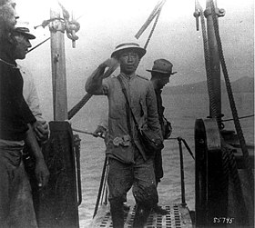
It was in Palanan that one of the final chapters of the Philippine–American War was written on March 23, 1901, when General Emilio Aguinaldo was captured by American forces led by General Frederick Funston, who had gained access to Aguinaldo’s camp by pretending to surrender to the Filipinos.
In 1978, the area around Palanan was proclaimed by President Ferdinand Marcos to be part of the Palanan Wilderness Area, a protected nature conservation area that was later expanded by President Fidel V. Ramos to become the Northern Sierra Madre Natural Park in 1997.
Geography[edit]

Palanan is one of the four remote and isolated coastal towns of Isabela facing the Philippine Sea on the east and separated from the rest of the province by the Sierra Madre Mountains. It is also a suburb of Ilagan City, the provincial capital.
Barangays[edit]
Palanan is politically subdivided into 17 barangays. [6] These barangays are headed by elected officials: Barangay Captain, Barangay Council, whose members are called Barangay Councilors. All are elected every three years.
- Alomanay
- Bisag
- Culasi
- Dialaoyao
- Dibewan
- Dicadyuan
- Dicotkotan
- Diddadungan
- Didyan
- Dimalicu-licu
- Dimasari
- Dimatican
- Ditambali
- Maligaya
- Marikit
- Centro East (Poblacion)
- Centro West (Poblacion)
Climate[edit]
| Climate data for Palanan, Isabela | |||||||||||||
|---|---|---|---|---|---|---|---|---|---|---|---|---|---|
| Month | Jan | Feb | Mar | Apr | May | Jun | Jul | Aug | Sep | Oct | Nov | Dec | Year |
| Average high °C (°F) | 27 (81) |
27 (81) |
29 (84) |
28 (82) |
27 (81) |
25 (77) |
26 (79) |
27 (81) |
31 (88) |
29 (84) |
27 (81) |
27 (81) |
28 (82) |
| Average low °C (°F) | 20 (68) |
20 (68) |
21 (70) |
20 (68) |
21 (70) |
20 (68) |
21 (70) |
22 (72) |
23 (73) |
23 (73) |
21 (70) |
21 (70) |
21 (70) |
| Average precipitation mm (inches) | 162 (6.4) |
156 (6.1) |
90 (3.5) |
60 (2.4) |
144 (5.7) |
201 (7.9) |
159 (6.3) |
108 (4.3) |
111 (4.4) |
237 (9.3) |
276 (10.9) |
171 (6.7) |
1,875 (73.9) |
| Average rainy days | 14 | 12 | 11 | 11 | 16 | 19 | 16 | 14 | 16 | 18 | 18 | 15 | 180 |
| Source: World Weather Online (modeled/calculated data, not measured locally)[7] | |||||||||||||
Demographics[edit]
| Year | Pop. | ±% p.a. |
|---|---|---|
| 1903 | 1,080 | — |
| 1918 | 2,410 | +5.50% |
| 1939 | 3,109 | +1.22% |
| 1948 | 4,045 | +2.97% |
| 1960 | 5,599 | +2.75% |
| 1970 | 7,518 | +2.99% |
| 1975 | 8,930 | +3.51% |
| 1980 | 10,295 | +2.88% |
| 1990 | 11,431 | +1.05% |
| 1995 | 13,220 | +2.76% |
| 2000 | 15,317 | +3.21% |
| 2007 | 16,254 | +0.82% |
| 2010 | 16,094 | −0.36% |
| 2015 | 17,260 | +1.34% |
| 2020 | 17,684 | +0.48% |
| Source: Philippine Statistics Authority [8] [9] [10][11] | ||
In the 2020 census, the population of Palanan, Isabela, was 17,684 people, [3] with a density of 20 inhabitants per square kilometre or 52 inhabitants per square mile.
Economy[edit]
Poverty Incidence of Palanan
Government[edit]
Local government[edit]
The municipality is governed by a mayor designated as its local chief executive and by a municipal council as its legislative body in accordance with the Local Government Code. The mayor, vice mayor, and the councilors are elected directly by the people through an election which is being held every three years.
Elected officials[edit]
| Position | Name |
|---|---|
| District Representative | Ed Christopher S. Go |
| Municipal Mayor | Angelo A. Bernardo |
| Municipal Vice-Mayor | Elizabeth B. Ochoa |
| Municipal Councilors | Robert B. Neri |
| Michael D. Ramilo | |
| Michael John D. Bernardo | |
| Pacita Q. Atanacio | |
| Ronnie A. Atienza | |
| Earl John Angelo S. Bernardo | |
| Rhoena O. Corpuz | |
| Ronaldo M. Bernardo |
Congress representation[edit]
Palanan, belonging to the second legislative district of the province of Isabela, currently represented by Hon. Ed Christopher S. Go.[20]
Education[edit]
The Schools Division of Isabela governs the town’s public education system.[21] The division office is a field office of the DepEd in Cagayan Valley region.[22] The office governs the public and private elementary and public and private high schools throughout the municipality.
Infrastructure[edit]
The most common forms of transportation in Palanan are by horses, motorcycles, tricycles, or an improvised motorcycles called kuligligs.[23][24] Due to its isolation, the town can be reached quickest by a 23-30 minute flight in a six-seater, single-engine Cyclone Air Cessna commuter plane from Cauayan. Palanan is served by Palanan Airport.[23][24]
By water, a boat ride from the neighboring town of Divilacan or in the towns of Dingalan and Baler in Aurora province in the south usually takes about two to three hours and six to seven hours, respectively.[24]
There are no roads that connect Palanan to the rest of province as the town can only be reached by a plane or boat ride, or a multi-day hike over the Sierra Madres from the neighboring town of San Mariano, which could take about three to five days.[25] However, there is a construction of an 82-kilometer Ilagan-Divilacan Road through the protected Sierra Madre mountains is on-going to open access to the coastal towns of Divilacan, Palanan and Maconacon. The approved budget contract of the project amounting to P1.5B, will pass through the foothills of the 359,486-hectare Northern Sierra Madre mountain ranges. The project will improve an old logging road used by a defunct logging company until the 1990s. It will start in Barangay Sindon Bayabo in Ilagan City and will end in Barangay Dicatian in Divilacan. The project is started in March 2016 and is expected to be completed in 2024.[26]
References[edit]
- ^ Municipality of Palanan | (DILG)
- ^ “2015 Census of Population, Report No. 3 – Population, Land Area, and Population Density” (PDF). Philippine Statistics Authority. Quezon City, Philippines. August 2016. ISSN 0117-1453. Archived (PDF) from the original on May 25, 2021. Retrieved July 16, 2021.
- ^ a b c Census of Population (2020). “Region II (Cagayan Valley)”. Total Population by Province, City, Municipality and Barangay. PSA. Retrieved 8 July 2021.
- ^ “PSA Releases the 2018 Municipal and City Level Poverty Estimates”. Philippine Statistics Authority. 15 December 2021. Retrieved 22 January 2022.
- ^ Salgado, Pedro. “Other Missions in Isabela”. Cagayan Valley and Easter Cordillera: 1581-1898, Volume I. Rex Publishing. pp. 496–499.
- ^ “Province: Isabela”. PSGC Interactive. Quezon City, Philippines: Philippine Statistics Authority. Retrieved 12 November 2016.
- ^ “Palanan, Isabela: Average Temperatures and Rainfall”. World Weather Online. Retrieved 31 October 2015.
- ^ Census of Population (2015). “Region II (Cagayan Valley)”. Total Population by Province, City, Municipality and Barangay. PSA. Retrieved 20 June 2016.
- ^ Census of Population and Housing (2010). “Region II (Cagayan Valley)”. Total Population by Province, City, Municipality and Barangay. NSO. Retrieved 29 June 2016.
- ^ Censuses of Population (1903–2007). “Region II (Cagayan Valley)”. Table 1. Population Enumerated in Various Censuses by Province/Highly Urbanized City: 1903 to 2007. NSO.
- ^ “Province of Isabela”. Municipality Population Data. Local Water Utilities Administration Research Division. Retrieved 17 December 2016.
- ^ “Poverty incidence (PI):”. Philippine Statistics Authority. Retrieved December 28, 2020.
- ^ https://psa.gov.ph/sites/default/files/NSCB_LocalPovertyPhilippines_0.pdf; publication date: 29 November 2005; publisher: Philippine Statistics Authority.
- ^ https://psa.gov.ph/sites/default/files/2003%20SAE%20of%20poverty%20%28Full%20Report%29_1.pdf; publication date: 23 March 2009; publisher: Philippine Statistics Authority.
- ^ https://psa.gov.ph/sites/default/files/2006%20and%202009%20City%20and%20Municipal%20Level%20Poverty%20Estimates_0_1.pdf; publication date: 3 August 2012; publisher: Philippine Statistics Authority.
- ^ https://psa.gov.ph/sites/default/files/2012%20Municipal%20and%20City%20Level%20Poverty%20Estima7tes%20Publication%20%281%29.pdf; publication date: 31 May 2016; publisher: Philippine Statistics Authority.
- ^ https://psa.gov.ph/sites/default/files/City%20and%20Municipal-level%20Small%20Area%20Poverty%20Estimates_%202009%2C%202012%20and%202015_0.xlsx; publication date: 10 July 2019; publisher: Philippine Statistics Authority.
- ^ “PSA Releases the 2018 Municipal and City Level Poverty Estimates”. Philippine Statistics Authority. 15 December 2021. Retrieved 22 January 2022.
- ^ “Palanan, Isabela Election Results 2022”. Rappler PH. ph.rappler.com. Retrieved May 13, 2022.
- ^ “House of Representatives: 19th Congress”. Official Website of the House of Representatives PH. congress.gov.ph. Retrieved May 15, 2022.
- ^ “HISTORY OF DEPED-ISABELA”. DepED Isabela | The official website of DepED Schools Division of Isabela. Retrieved March 13, 2022.
{{cite web}}: CS1 maint: url-status (link) - ^ “DEPED REGIONAL OFFICE NO. 02”. DepED RO2 | The official website of DepED Regional Office No. 02.
{{cite web}}: CS1 maint: url-status (link) - ^ a b Christian (2011-06-13). “Palanan and Maconacon”. Off the Beaten Track in the Philippines. Retrieved on 2023-03-16.
- ^ a b c Jay (2013-01-09). “Palanan – Isabela’s Best Kept Secrets”. Lets Go Philippines. Retrieved on 2014-09-28.
- ^ “The Palanan Trails”. Waypoint.PH. Retrieved on 2023-03-16.
- ^ “P2.3-B Isabela road link completed soon”. The Manila Times. January 4, 2018. Retrieved 16 March 2023.
External links[edit]
Recent Comments