2022 Atlantic hurricane season – Wikipedia
Hurricane season in the Atlantic Ocean
The 2022 Atlantic hurricane season was the first season since 1997 in which no tropical cyclones formed in August, and the first season on record to do so during a La Niña year. It was a fairly average hurricane season with an average number of named storms, a slightly above-average number of hurricanes, a slightly below-average number of major hurricanes (category 3 or higher on the 5-level Saffir–Simpson wind speed scale), and a near-normal accumulated cyclone energy (ACE) index.[nb 2][1] Despite this, it became one of the costliest Atlantic hurricane seasons on record, mostly due to Hurricane Ian.[2] There were fourteen named storms during the season. Eight of them strengthened into a hurricane, and two reached major hurricane intensity. The season officially began on June 1, and ended on November 30. These dates, adopted by convention, historically describe the period in each year when most subtropical or tropical cyclogenesis occurs in the Atlantic Ocean.[3] This year’s first named storm, Tropical Storm Alex, developed five days after the start of the season, making this the first season since 2014 not to have a pre-season named storm.
Two systems developed on July 1. Tropical Storm Bonnie formed and made landfall near the Costa Rica–Nicaragua border. It then crossed over into the Pacific basin, becoming the first to survive the crossover from the Atlantic to the Pacific since Hurricane Otto in 2016. Also, Tropical Storm Colin formed abruptly and made landfall in South Carolina. It quickly weakened and dissipated the next day. Following this activity, tropical cyclogenesis was suppressed across the basin for several weeks by a combination of high wind shear, drier air, and the presence of the Saharan Air Layer.[4] After a 60-day lull in tropical cyclone activity, Hurricanes Danielle and Earl formed on September 1 and 3 respectively, with Danielle becoming the season’s first hurricane. The last season to have its first hurricane develop this late was 2013.[5]
Activity then increased tremendously towards the end of the month as four named storms formed in quick succession. Among them, Hurricane Fiona became the season’s first major hurricane on September 20, which is about three weeks later than when the first one typically forms.[6] As an extratropical cyclone it became the strongest storm in Canadian history, as measured by central pressure, and caused significant damage in Atlantic Canada. Hurricane Ian then became the second major hurricane of the season on September 27 and the only Category 5 of the season on September 28, before inflicting major to catastrophic damage upon Western Cuba, Southwestern and Central Florida, and the Carolinas. Hurricane Julia formed in early October and became the second storm of the season to cross over into the Pacific basin intact after traversing Nicaragua, making this season the first to have more than one crossover system since 1996. The last storm in the season, Hurricane Nicole, made landfall on the coasts of The Bahamas and Florida. It was the first November hurricane to make landfall in Florida since Kate in 1985, and caused heavy damage in areas devastated by Ian six weeks earlier.[7]
Seasonal forecasts[edit]
| Source | Date | Named storms |
Hurricanes | Major hurricanes |
Ref |
| Average (1991–2020) | 14.4 | 7.2 | 3.2 | [8] | |
| Record high activity | 30 | 15 | 7† | [9] | |
| Record low activity | 4 | 2† | 0† | [9] | |
|
|
|||||
| CSU | December 9, 2021 | 13–16 | 6–8 | 2–3 | [10] |
| TSR | December 10, 2021 | 18 | 8 | 3 | [11] |
| TSR | April 6, 2022 | 18 | 8 | 4 | [12] |
| CSU | April 7, 2022 | 19 | 9 | 4 | [13] |
| TWC | April 14, 2022 | 20 | 8 | 4 | [14] |
| UA | April 14, 2022 | 14 | 7 | 3 | [15] |
| NCSU | April 20, 2022 | 17–21 | 7–9 | 3–5 | [16] |
| PSU | May 9, 2022 | 11-19 | N/A | N/A | [17] |
| UKMO* | May 23, 2022 | 18 | 9 | 4 | [18] |
| NOAA | May 24, 2022 | 14–21 | 6–10 | 3–6 | [19] |
| TSR | May 31, 2022 | 18 | 8 | 4 | [20] |
| CSU | June 2, 2022 | 20 | 10 | 5 | [21] |
| TWC | June 17, 2022 | 21 | 9 | 4 | [22] |
| UA | June 20, 2022 | 15 | 7 | 3 | [23] |
| TSR | July 5, 2022 | 18 | 9 | 4 | [24] |
| CSU | July 7, 2022 | 20 | 10 | 5 | [25] |
| UKMO | August 2, 2022 | 16 | 6 | 4 | [26] |
| NOAA | August 4, 2022 | 14–20 | 6–10 | 3–5 | [27] |
| CSU | August 4, 2022 | 18 | 8 | 4 | [27] |
| TWC | August 18, 2022 | 17 | 7 | 3 | [28] |
|
|
|||||
| Actual activity | 14 | 8 | 2 | ||
| * June–November only † Most recent of several such occurrences. (See all) |
|||||
In advance of, and during, each hurricane season, several forecasts of hurricane activity are issued by national meteorological services, scientific agencies, and noted hurricane experts. These include forecasters from the United States National Oceanic and Atmospheric Administration (NOAA)’s Climate Prediction Center, Tropical Storm Risk (TSR), the United Kingdom’s Met Office (UKMO), and Philip J. Klotzbach, William M. Gray and their associates at Colorado State University (CSU). The forecasts include weekly and monthly changes in significant factors that help determine the number of tropical storms, hurricanes, and major hurricanes within a particular year. According to NOAA and CSU, the average Atlantic hurricane season between 1991 and 2020 contained roughly 14 tropical storms, seven hurricanes, three major hurricanes, and an accumulated cyclone energy (ACE) index of 74–126 units.[29] Broadly speaking, ACE is a measure of the power of a tropical or subtropical storm multiplied by the length of time it existed. It is only calculated for full advisories on specific tropical and subtropical systems reaching or exceeding wind speeds of 39 mph (63 km/h).[8] NOAA typically categorizes a season as above-average, average, or below-average based on the cumulative ACE index, but the number of tropical storms, hurricanes, and major hurricanes within a hurricane season is sometimes also considered.[8]
Pre-season forecasts[edit]
On December 9, 2021, CSU issued an extended range forecast for the 2022 hurricane season, giving a 40% chance of near-average activity with 13–16 named storms, 6–8 hurricanes, 2–3 major hurricanes, and an ACE index of about 130 units. The forecast also gave a 25% chance that the ACE Index would end up being around 170 units, and a 25% likelihood the likelihood that the index would end up around 80.[10] TSR also issued an extended range forecast on December 10, 2021.[11] It predicted overall near-average tropical activity with its ACE index, anticipating 18 tropical storms, 8 hurricanes and 3 intense hurricanes to form during the season. One of their factors was the expectation of a neutral El Niño-Southern Oscillation condition by the third quarter of 2022. This outlook had “large uncertainties”.[11]
On April 7, CSU issued their first extended range seasonal forecast for the 2022 Atlantic hurricane season, predicting well above-average activity, with 19 named storms, 9 hurricanes, 4 major hurricanes and an ACE index of 160 units. Their factors supporting an active hurricane season included above average-sea surface temperatures in the subtropical Atlantic Ocean and Caribbean Sea, and a cool neutral ENSO or weak La Niña pattern, corresponding to a low chance of an El Niño.[30] On April 14, 2022, University of Arizona (UA) issued its seasonal prediction for a slightly above-average hurricane season, with 14 named storms, seven hurricanes, three major hurricanes, and an ACE index of 129 units.[15]North Carolina State University (NCSU) made its prediction for the season on April 20, calling for an above-average season with 17 to 21 named storms, 7 to 9 hurricanes, and 3 to 5 major hurricanes.[16]
On May 23, UKMO issued their own forecast for the 2022 season, predicting an above average season with 18 named storms, 9 hurricanes, and 4 major hurricanes, with a 70% chance that each of these statistics will fall between 13 and 23, 6 and 12, and 2 and 6, respectively.[18] The following day, NOAA’s Climate Prediction Center issued their forecasts for the season, predicting a 65% chance of above-average activity and 25% chance for below-average activity, with 14–21 named storms, 6–10 hurricanes, and 3–6 major hurricanes.[19]
Mid-season forecasts[edit]
On June 2, CSU updated their extended range seasonal forecast, increasing the amount of tropical cyclones to 20 named storms, 10 hurricanes, 5 major hurricanes, and an overall ACE index of 180 units. This was done after later analysis of lower chances of an El Niño during the season, as well as a warmer than average tropical Atlantic.[31] On June 20, 2022, University of Arizona (UA) updated its seasonal prediction, which is very similar to its April prediction, with 15 named storms, seven hurricanes, three major hurricanes, and an ACE index of 131 units.[23] On July 5, TSR released their third forecast for the season, slightly increasing their numbers to 18 named storms, 9 hurricanes, and 4 major hurricanes. This prediction was largely based on the persistence of the weak La Niña into the third quarter of the year.[24] On July 7, CSU did not make changes to their updated prediction of 20 named storms, 10 hurricanes, and 5 major hurricanes.[25] UKMO’s updated forecast on August 2 called for 16 named storms, 6 hurricanes, and 4 major hurricanes.[26] Two days later, NOAA and CSU each revised their activity outlook slightly downward, though both still predicted that the season would end up being busier than the 30-year average. The revisions were made in part because of the relative slow start to the season (as compared to the past couple), with only three short-lived named storms as of the start of August.[27]
Seasonal summary[edit]

The 2022 season was the first season since 2014 to not have a pre-season named storm.[32] It was also the first season not to have above-average activity overall since 2015. Activity began with the formation of Tropical Storm Alex on June 5, after several days of slow development while traversing the Gulf of Mexico and then moving over Central Florida.[33] The storm peaked at near-hurricane strength before becoming extratropical over the Central North Atlantic. On July 1, Tropical Storm Bonnie formed in the Southern Caribbean Sea and made landfall shortly thereafter near the Costa Rica–Nicaragua border. It then crossed over into the Pacific basin a day later, the first storm to do so since Hurricane Otto in 2016,[34] where it would become a Category 3 hurricane. Also on July 1, a low-pressure system off the U.S. Atlantic coast near Savannah, Georgia abruptly organized into Tropical Storm Colin, a short-lived storm that dissipated the next day inland over northeastern South Carolina. Tropical activity then ceased, with no tropical cyclones forming for almost two months. 2022 became the first season since 1997 to not have a tropical cyclone form in August.[35] One disturbance over the Gulf of Mexico during the middle of the month was briefly designated as a potential tropical cyclone, but it did not organize into a tropical cyclone before moving inland over Northeastern Mexico.[36]

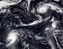
Tropical activity ultimately resumed with the formation of Tropical Storm Danielle over the central Atlantic on September 1. The storm intensified into a hurricane the following day, the latest “first hurricane of the season” since 2013.[37] It remained nearly stationary far to the west of the Azores for several days before moving northeastward and becoming extratropical on September 8 without affecting any land areas. Additionally, a slow-developing disturbance east of the Lesser Antilles became organized and developed into Tropical Storm Earl late on September 2–3.[38] It strengthened into a hurricane, tracked east of Bermuda, fluctuating between Category 1 and 2 intensity, and then became extratropical near Newfoundland on September 10. Four days later, Tropical Storm Fiona formed in the Central Atlantic. Fiona eventually became a hurricane, striking both Puerto Rico and the Dominican Republic before becoming the season’s first major hurricane as it passed by the Turks and Caicos Islands on September 20. That same day, Tropical Storm Gaston formed over the Central Atlantic and moved through the Western Azores. Fiona strengthened into a Category 4 hurricane as it passed west of Bermuda and transitioned into a powerful extratropical cyclone on September 23, just before striking Nova Scotia. That same day, Tropical Depression Nine formed in the Caribbean Sea and Tropical Depression Ten formed in the eastern tropical Atlantic, marking the first time since 2020 that four tropical cyclones were active simultaneously in the Atlantic basin.[39]
| Rank | Cost | Season |
|---|---|---|
| 1 | ≥ $294.803 billion | 2017 |
| 2 | $172.297 billion | 2005 |
| 3 | $120.425 billion | 2022 |
| 4 | ≥ $80.727 billion | 2021 |
| 5 | $72.341 billion | 2012 |
| 6 | $61.148 billion | 2004 |
| 7 | ≥ $51.114 billion | 2020 |
| 8 | ≥ $50.526 billion | 2018 |
| 9 | ≥ $48.855 billion | 2008 |
| 10 | $27.302 billion | 1992 |
Tropical Depression Nine became Hurricane Ian, the most deadly and destructive storm of the season, and its strongest in terms of winds. Ian made landfall in western Cuba and crossed the Florida Keys as a Category 3 hurricane, before briefly becoming a Category 5 hurricane. It then made landfall in southwestern Florida as a high-end Category 4 hurricane, and later in South Carolina as a Category 1.[40] Tropical Depression Ten attained tropical storm strength first, becoming Tropical Storm Hermine. It was one of the easternmost Atlantic tropical storms on record, and brought heavy rainfall to the Canary Islands. Next, Tropical Depression Eleven formed during the last week in September, and then Tropical Depression Twelve formed one week later. Ultimately, neither cyclone strengthened into a tropical storm. Soon thereafter, Hurricane Julia formed just off the coast of Venezuela. After traversing Nicaragua intact, Julia entered the Pacific basin. Not since 1996 has more than one storm crossed between the Atlantic and Pacific basins intact during a single season.[41] On October 11, Tropical Storm Karl formed in the Bay of Campeche, moved erratically over open waters, before degenerating into a remnant low offshore of Mexico. Two systems were at hurricane strength on November 2: Lisa, in the Caribbean, and Martin, in the central Atlantic. Thus, for the first time since Michelle and Noel in 2001, two Atlantic hurricanes were at hurricane strength simultaneously during November.[42] Soon thereafter, Hurricane Nicole formed and impacted the Greater Antilles, The Bahamas, and the Southeastern United States.
This season’s ACE index, as calculated by Colorado State University using data from the NHC, was approximately 95.1 units,[43] which was 80% of the long-term (30-year) average.[1] The ACE number represents the sum of the squares of the maximum sustained wind speed (knots) for all named storms while they are at least tropical storm intensity, divided by 10,000. Therefore, tropical depressions are not included.[44]
Systems[edit]
Tropical Storm Alex[edit]
  |
|
| Duration | June 5 – June 6 |
|---|---|
| Peak intensity | 70 mph (110 km/h) (1-min) 984 mbar (hPa) |
In late May, the mid-level remnants of Hurricane Agatha in the Pacific basin interacted with a Central American Gyre. Consequently, a gradual increase in deep convection occurred over the Yucatán Peninsula and the northwestern Caribbean Sea, which led to the development of a low-pressure area just north of the Belize-Mexico border on June 2. After emerging into the southeastern Gulf of Mexico early the next day, the disturbance made multiple attempts at organizing into a tropical cyclone and attained tropical storm-force winds. However, strong wind shear kept the system disorganized before it struck Southwest Florida on June 4. Several hours later, the disturbance emerged into the Atlantic, where it to develop into Tropical Storm Alex at 00:00 UTC on June 5 about 85 mi (135 km) north of Grand Bahama. Additional intensification occurred as Alex moved east-northeastward due to mid-latitude westerly flow, reaching sustained winds of 70 mph (110 km/h) around 18:00 UTC. However, drier air caused Alex to weaken on the following day, with the storm transitioning into an extratropical cyclone at 12:00 UTC roughly 105 mi (170 km) north-northwest of Bermuda. The remnants of Alex were absorbed by a baroclinic zone early on June 7.[45]
Due to the threat the developing system posed to Cuba, the Florida Keys, and South Florida, the National Hurricane Center initiated advisories on it, designating it as Potential Tropical Cyclone One. The precursor to Alex dropped heavy precipitation in these regions.[45] During a 30-hour period on June 2–3, Paso Real de San Diego in the province of Pinar del Río recorded about 12 inches (301 mm) of rain, and Playa Girón in Matanzas received over 8 inches (193 mm).[46] There were four storm-related deaths in Cuba, while about 750 homes, 7,900 acres (3,200 ha) of crops,[45] and numerous bridges suffered flood damage.[47] In Florida, several locations in the Upper Keys and the Miami metropolitan area observed between 10 and 15 in (250 and 380 mm) of rainfall, with a peak total of 15.28 in (388 mm) near Hollywood. Extensive street flooding occurred in the Miami area, but water entered few properties. Across Broward and Miami-Dade counties combined, there were about 3,500 power outages.[45] Damage from the precursor to Alex in Florida totaled $104,000.[48]
Tropical Storm Bonnie[edit]
  |
|
| Duration | July 1 – July 2 (Exited basin) |
|---|---|
| Peak intensity | 60 mph (95 km/h) (1-min) 996 mbar (hPa) |
A low-altitude tropical wave entered the Atlantic from the west coast of Africa on June 22, producing a large but disorganized area of showers and thunderstorms. Thunderstorm activity increased by June 27, while a NOAA Hurricane Hunters mission reported tropical-storm-force winds but no well-defined closed circulation. However, due to the threat the system posed to the Lesser Antilles, the NHC initiated advisories on it as Potential Tropical Cyclone Two later that same day. Later, after crossing the southern Windward Islands on June 28 and passing near the coast of Venezuela on the following day, the disturbance encountered more favorable conditions but failed to develop a distinct low-level circulation due to its fast forward speed and interaction with land. As the disturbance moved toward Central America on the morning of July 1, it became sufficiently organized to be classified as Tropical Storm Bonnie.[49] Embedded in an environment of low wind shear and warm seas, Bonnie started to steadily intensify.[50] At 03:00 UTC on July 2, Bonnie made landfall near the Costa Rica–Nicaragua border at its peak intensity within the Atlantic with sustained winds of 60 mph (95 km/h). Bonnie then crossed Central America and exited into the Eastern Pacific basin around 12:00 UTC on July 2.[49]
Bonnie and its precursor disturbance produced gusty winds and heavy rainfall as it tracked through the southern Caribbean Sea.[51] On Trinidad, floodwaters damaged at least 40 homes in one village and left approximately 200,000 people without potable water.[49] Heavy rainfall and landslides in Panama led to the evacuation of several families in Chiriquí Province.[52] In Costa Rica, over 3,000 people evacuated as a result of flooding and mudslides,[49] while 8,593 households lost electricity.[53] Over 10,000 people lost power during the storm in Nicaragua. Four deaths occurred in the country, three after being swept away in rising rivers and one while attempting to rescue other people from a bus being carried away. Overall, Bonnie caused about $25 million in damage throughout the impacted regions.[49]
Tropical Storm Colin[edit]
  |
|
| Duration | July 1 – July 2 |
|---|---|
| Peak intensity | 40 mph (65 km/h) (1-min) 1011 mbar (hPa) |
A low-pressure are formed along a surface trough offshore Savannah, Georgia, on July 1. The system then unexpectedly organized into a tropical depression around 18:00 UTC that day, and strengthened into Tropical Storm Colin at 23:30 UTC as it made landfall near Hunting Island, South Carolina. Simultaneously, Colined peaked with maximum sustained winds of 40 mph (65 km/h). The center of the storm remained just inland over coastal South Carolina on July 2, though most of its heavy rains and strong winds remained out over the Atlantic due to its proximity to the coast and wind shear.[54] Colin became increasingly disorganized later that day, with its circulation becoming elongated due to the wind shear and continued land interaction.[55] By 18:00 UTC on July 2, Colin fell to tropical depression intensity. The storm continued to weaken rapidly, and its low-level circulation dissipated over northeastern South Carolina by the end of that day.[54]
A few locations from northeast Florida to southeastern North Carolina observed 3 to 4 in (76 to 102 mm) of precipitation. In South Carolina, rainfall amounts ranged from 1–3 in (25–76 mm) in parts of the Midlands region to a peak total of 7.59 in (193 mm) near Wadmalaw Island.[54] A Fourth of July weekend event in Charleston was cancelled because of flooding at the event site, as was a festival in Southport, North Carolina.[56] However, only minor damage occurred overall. One person drowned offshore Oak Island, North Carolina, due to rip currents generated by Colin.[54]
Hurricane Danielle[edit]
  |
|
| Duration | September 1 – September 8 |
|---|---|
| Peak intensity | 85 mph (140 km/h) (1-min) 972 mbar (hPa) |
On August 31, an area of low pressure formed along a decaying frontal zone over the central subtropical Atlantic. The disturbance quickly developed into Tropical Depression Five early on September 1 roughly 715 mi (1,150 km) southeast of Cape Race, Newfoundland, before strengthening into Tropical Storm Danielle by 12:00 UTC. Favorable conditions such as abnormally warm seas and light wind shear allowed Danielle to become a hurricane around 24 hours later. The hurricane stalled on September 2, caught south of a blocking high, and weakened back to a tropical storm the next day due to upwelling of cooler waters. Later, the storm drifted westward, where it again strengthened into a hurricane early on September 4. After turning northwestward, Danielle reached its peak intensity with sustained winds of 85 mph (140 km/h) late the following day.[57] It then moved over a relatively cool part of the Gulf Stream and weakened to a low-end Category 1 hurricane.[58] The hurricane briefly re-intensified when it moved over marginally warm waters on September 7, but resumed a weakening trend shortly thereafter.[59] Danielle weakened to a tropical storm early on September 8, before transitioning into an extratropical cyclone later that day. The remnant extratropical system meandered over the northeastern Atlantic before dissipating offshore Portugal on September 15.[57]
The remnants of Danielle dissipated offshore Portugal as an extratropical cyclone, bringing heavy rain to the country, including 3.3 in (84 mm) of precipitation in Guarda in 24 hours.[57] Between September 12–13, 644 accidents were reported throughout the country, along with many instances of downed trees and flash floods.[60] In Manteigas, which had been ravaged by intense summer forest fires in nearby areas of the Serra da Estrela mountain range, floods and landslides caused major damage and at least four vehicles were dragged into the Zêzere River. Portuguese authorities also reported minor wind and flood damage in Lisbon and Setúbal.[61] Much of Spain was put on yellow alert as wind, rain and thunderstorms triggered by the cyclone moved inland.[62]
Hurricane Earl[edit]
  |
|
| Duration | September 2 – September 10 |
|---|---|
| Peak intensity | 110 mph (175 km/h) (1-min) 948 mbar (hPa) |
On August 25, a tropical wave emerged into the Atlantic from the west coast of Africa. Convective activity remained sporadic and disorganized for several days as the wave moved generally west-northwestward through an environment of dry air and unfavorable wind shear. However, convection markedly increased on September 1 as the system approached warm waters near the Lesser Antilles. Late on the following day, the system organized into Tropical Storm Earl approximately 205 mi (330 km) east of Barbuda. Continuously unconducive wind shear prevented significant intensification before Earl turned northward on September 5 through a break in a subtropical ridge over the central Atlantic. Possibly due to a diffluent environment and favorable thermodynamic conditions, Earl intensified into a hurricane late on September 6. The storm briefly strengthened into a Category 2 hurricane early on September 8 but then weakened later that day, likely due to dry air.[63]
Around 12:00 UTC on September 9, Earl re-strengthened into a Category 2 hurricane. About 12 hours later, the hurricane peaked with sustained winds of 110 mph (175 km/h) and a minimum barometric pressure of 948 mbar (28.0 inHg) as it accelerated northeastward in advance of a mid-latitude trough. However, Earl soon began losing tropical characteristics and transitioned into an extratropical cyclone around 18:00 UTC on September 10, about 230 mi (370 km) south of Cape Race, Newfoundland. The extratropical remnants executed a cyclonic loop south of Newfoundland before moving generally eastward across the Atlantic before dissipating late on September 15.[63]
The outerbands of Earl produced rainfall amounts generally ranging from 3 to 5 in (76 to 127 mm) in eastern Puerto Rico, while a weather station near Finca La Loma recorded a peak total of 7.7 in (200 mm) of precipitation. Two people died near Salinas after being struck by lightning while riding a jet ski. Bermuda was buffeted with sustained winds of 35 mph (60 km/h) as Hurricane Earl passed within about 90 mi (145 km) of the island’s eastern coast; higher gusts were reported, including one of 67 mph (108 km/h) at the National Museum of Bermuda.[63] There were localized power outages across the archipelago but no large-scale damage was observed.[64] During a 36-hour period September 10–12, 7–8 in (175–200 mm) of rain fell in the St. Johns area of Newfoundland and Labrador,[65] causing the Waterford River to overflow, which led to urban flooding. Similar rainfall amounts were also reported in communities throughout the Avalon Peninsula. Additionally, the cyclone generated rough surf which damaged the breakwater on the coast in the area of Trepassey, causing localized flooding.[63]
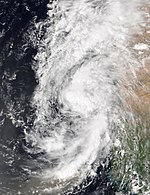
Hurricane Fiona[edit]
  |
|
| Duration | September 14 – September 23 |
|---|---|
| Peak intensity | 140 mph (220 km/h) (1-min) 931 mbar (hPa) |
A tropical wave exited the west coast of Africa and entered the Atlantic on September 7. Although shower and thunderstorm activity was initially organized, dry air significantly limited convection as the wave trekked westward for several days. However, convection began increasing on September 12 and consolidating late on September 13. A well-defined circulation formed early the following day, leading to the development of a tropical depression approximately 1,035 mi (1,665 km) east of the Lesser Antilles. Although the depression strengthened into Tropical Storm Fiona later on September 14, wind shear prevented further significant intensification for a few days as the storm continued to move generally westward. Late on September 16, Fiona struck Guadeloupe with winds of 60 mph (95 km/h). After entering the Caribbean, the cyclone encountered decreasing wind shear, allowing it to intensify into a hurricane on September 18. At 19:20 UTC, Fiona made landfall in the Lajas municipality of Puerto Rico near Punta Tocon with winds of 85 mph (140 km/h). The storm quickly emerged into the Mona Passage and moved west-northwestward until striking the Dominican Republic near Boca de Yuma with winds of 90 mph (150 km/h) around 07:30 UTC on September 19.[66]
Fiona emerged into the Atlantic from the north coast of the Dominican Republic later on September 19 and soon intensified into a Category 2 hurricane. The storm then reached Category 3 intensity early on the following day, prior to striking Grand Turk Island around 11:00 UTC. Thereafter, Fiona moved north-northeastward due to a weakness in the subtropical ridge and strengthened into a Category 4 hurricane early on September 21. At that time, the cyclone peaked with sustained winds of 140 mph (220 km/h). Although sustained winds then decreased slightly, the storm’s minimum pressure fell to 931 mbar (27.5 inHg) early on September 23. Fiona also expanded significantly that day while passing about 115 mi (185 km) northwest of Bermuda around 10:00 UTC. The storm accelerated northeastward and then north-northeastward while merging with a cold front several hours later, with Fiona becoming extratropical by 00:00 UTC on September 24 approximately 220 mi (355 km) southeast of Halifax, Nova Scotia. The remnants of Fiona remained intense and struck Nova Scotia around 07:00 UTC that day and then extreme eastern Quebec on September 25, several hours before reaching the Labrador Sea. The extratropical cyclone dissipated just offshore Nuuk, Greenland, late on September 27.[66]
Several of the Leeward Islands recorded tropical storm-force winds and heavy rainfall, with up to 22.22 in (564 mm) of precipitation on Guadeloupe, leading to one death after the overflowing Rivière des Pères swept away a house.[66] Still recovering from the effects of Hurricane Maria in 2017 and saturated from precipitation produced by Earl,[67] torrential rains fell island-wide on Puerto Rico on September 18–19, exceeding 30 in (760 mm) in some regions, causing destructive flash flooding, landslides, and rockfalls that washed out or blocked numerous roads and bridges. In addition, the effects of the storm resulted in an island-wide power grid failure. A loss of approximately 90% of commercial crops also occurred. Overall, Fiona caused 23 deaths and about $2.5 billion in damage in Puerto Rico, making Fiona the island’s third costliest tropical cyclone on record. In the Dominican Republic, heavy rainfall and hurricane-force winds destroyed more than 2,000 homes and damaged about 8,500 others, displacing over 43,000 people. More than 400,000 people lost electricity and 1.2 million people experienced a disruption of water services. Two deaths occurred in the country. In the Turks and Caicos Islands, strong winds downed many trees and power poles and damaged some homes. Similar impacts were reported in Bermuda, along with approximately 29,000 customers losing electricity. In Atlantic Canada, strong winds felled thousands of power lines and trees across the region, leaving over 500,000 customers without electricity and causing significant damage to roofs and windows in Nova Scotia. Large waves and storm surge demolished more than 100 homes in southwestern Newfoundland and flooded many dwellings and businesses on the Magdalen Islands. Eight deaths were reported in Atlantic Canada, while insured losses alone reached $800 million, making the remnants of Fiona the costliest weather disaster in the region’s history.[66]
Tropical Storm Gaston[edit]
  |
|
| Duration | September 20 – September 25 |
|---|---|
| Peak intensity | 65 mph (100 km/h) (1-min) 994 mbar (hPa) |
A tropical wave moved off the west coast of Africa and entered the Atlantic on September 12, initially producing disorganized showers and thunderstorms. After the wave moved generally westward to about midway between Africa and the Lesser Antilles, deep convection began consolidating along its northern side between September 16 and September 17. Although a surface low developed on September 19, convection remained disorganized. However, upon acquiring a well-defined center and persistent deep convection on September 20, the system became Tropical Depression Eight about 1,100 mi (1,770 km) east of Bermuda. The depression strengthened into Tropical Storm Gaston six hours later while moving north-northeastward along the western edge of a high-pressure area. Despite only marginally warm water temperatures and moderate to strong wind shear, Gaston strengthened to peak with sustained winds of 65 mph (100 km/h) early on September 21.[68]
However, additional strengthening was prevented as dry air intruded into Gaston. A blocking mid-level high pressure caused the storm to turn southeastward and then southwestward on September 23 and later to the westward on the following day.[68] Passing between the Azores late on September 23 and early on September 24, Gaston generated heavy rainfall across the archipelago, especially in the western and central islands.[69] A weather station at Horta on Faial Island measured a wind gust of 41 mph (66 km/h) as Gaston passed through. Convection diminished significantly as the storm continued westward and by 00:00 UTC on September 26, Gaston became extratropical about 345 mi (555 km) west-southwest of Flores Island. The remnant low moved west-southwestward until dissipating about 48 hours later.[68]
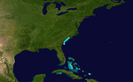
Hurricane Ian[edit]
  |
|
| Duration | September 23 – September 30 |
|---|---|
| Peak intensity | 160 mph (260 km/h) (1-min) 937 mbar (hPa) |
Between September 14 and September 15, a tropical wave emerged into the Atlantic from the west coast of Africa and moved westward for several days with disorganized showers and thunderstorms. Although the system gained additional convection upon reaching the southeastern Caribbean on September 21, wind shear prevented further development. By 06:00 UTC on September 23, however, Tropical Depression Nine formed around 150 mi (240 km) east-northeast of Aruba. The depression moved west-northwestward due to a building mid-level ridge and strengthened into Tropical Storm Ian early the next day. Ian then turned westward and initially failed to intensify further in an environment with moderate to strong wind shear. After curving to the northwest, the storm strengthened into a hurricane early on September 26. Thereafter, Ian rapidly intensified, becoming a major hurricane about 24 hours later. Around 08:30 UTC on September 27, the hurricane made landfall in Cuba near La Coloma, Pinar del Río Province, with winds of 125 mph (205 km/h). The cyclone hardly weakened while crossing Cuba and emerged into the Gulf of Mexico around 14:00 UTC.[70]
Early on September 28, Ian struck Dry Tortugas, Florida, with winds of 125 mph (205 km/h) as the storm headed north-northeastward along a broad trough and the western periphery of a subtropical ridge. Favorable conditions in the Gulf of Mexico then allowed another period of rapid deepening to commence. At 12:00 UTC on September 28, Ian briefly attained Category 5 status and peaked with maximum sustained winds of 160 mph (260 km/h) and a minimum barometric pressure of 937 mbar (27.7 inHg). Less favorable conditions caused Ian to weaken to a Category 4 hurricane prior to its landfall on Cayo Costa Island, Florida, with winds of 150 mph (240 km/h), at 19:05 UTC. About an hour and a half later, the storm struck near Punta Gorda, with winds of 145 mph (230 km/h). The hurricane weakened while slowly traversing the Florida peninsula, falling to tropical storm status while emerging into the Atlantic near Cape Canaveral at 12:00 UTC on September 29. Although most of its convection was displaced north of the center, Ian quickly re-intensified into a hurricane six hours later. Early on September 30, the storm accelerated after turning northward. Ian made its final landfall at 18:05 UTC near Georgetown, South Carolina, with winds of 80 mph (130 km/h). The storm soon merged with a cold front and transitioned into an extratropical cyclone by 00:00 UTC on October 1. Several hours later, the remnants of Ian dissipated over North Carolina.[70]
While in the early stages of developing, the system brought gusty winds and heavy rain to Trinidad and Tobago,[71][72] the ABC islands, and to the northern coast of South America on September 21–22.[73] Ian also caused five deaths in Cuba.[70] Much of western portions of the country experienced hurricane-force winds and heavy rainfall, which exceeded 20 in (510 mm) in some areas.[70] Consequently, Ian left extensive impacts to factories, hospitals, roads, tobacco farms, and homes,[74] with more than 100,000 dwellings damaged or destroyed in Pinar del Río Province alone.[70] Three provinces initially lost power, but later the nation’s entire electrical grid collapsed.[75] Significant storm surge inundation occurred along the coasts of the Gulf of Guanahacabibes and Isla de la Juventud.[76] Storm surge and high winds led to extreme damage in Southwest Florida. Lee County, where Ian made its first landfall in Florida at Category 4 intensity and produced a storm surge which peaked at 7.25 ft (2.21 m) in Fort Myers, reported some degree of impact to 52,514 structures, with 5,369 of those demolished and 14,245 others extensively damaged. Bridges and roadways, especially along the coast or on the barrier islands, also suffered major impacts. In neighboring Collier County, strong winds and storm surge inflicted major damage to more than 3,500 buildings and destroyed 33 others. The outerbands of Ian spawned 14 tornadoes in Florida, including an EF-2 tornado that caused significant damage to some condominiums and injured two people in Kings Point.[77] Ian also produced historic flooding across Central Florida due to a wide swath of rainfall totals generally ranging from 10–20 in (250–510 mm), with Osceola, Seminole, and Volusia counties reporting damage or destruction to thousands of buildings and homes. More than 3.28 million customers across the state lost electricity. An estimated 150 fatalities occurred in Florida, with 36 of the direct deaths reported in Lee County. Later, heavy rainfall and storm surge caused damage from the Carolinas to Maryland, but to a much lesser extent than in Florida. Ian also left five fatalities in North Carolina and one in Virginia, all due to indirect causes. Overall, Ian caused approximately $112.9 billion in damage in the United States, making it the nation’s third costliest tropical cyclone.[70]
Tropical Storm Hermine[edit]
  |
|
| Duration | September 23 – September 24 |
|---|---|
| Peak intensity | 40 mph (65 km/h) (1-min) 1003 mbar (hPa) |
On September 22, a tropical wave being monitored by the NHC emerged off the coast of West Africa into the tropical Atlantic east of Cabo Verde.[73] It quickly organized, becoming Tropical Depression Ten at 12:00 UTC on September 23, and then strengthened into Tropical Storm Hermine six hours later.[78] It is one of few tropical cyclones on record to form and to track between the Cabo Verde Islands and the coast of Africa.[73] Development beyond a weak, 40 mph (65 km/h)-tropical storm was stymied by southwesterly shear into the next day as the system moved northward. On account of the shear, Hermine weakened into a tropical depression at 12:00 UTC on September 24, and degenerated into a post-tropical low within 12 hours, while situated about 240 mi (385 km) northwest of Nouadhibou, Mauritania. The remnant low moved northeastward until degenerating into a surface trough early on September 26 to the southwest of the Canary Islands.[78]
Hermine brought heavy rainfall to the Canary Islands, peaking at 20.87 in (530 mm) on La Palma, which damaged many schools and some roadways, caused power outages impacting several thousands of people,[78] and downed trees. Additionally, more than 140 flights were cancelled across the archipelago.[79] Damage in the Canary Islands exceeded 10 million euro (US$9.8 million),[80] while no fatalities were reported there.[78]
Tropical Depression Eleven[edit]
  |
|
| Duration | September 28 – September 29 |
|---|---|
| Peak intensity | 35 mph (55 km/h) (1-min) 1008 mbar (hPa) |
On September 17, a tropical wave emerged into the Atlantic from the west coast of Africa. After producing disorganized convective activity for the next few days as the wave headed westward, showers and thunderstorms consolidated enough on September 20 that a low-pressure area formed. The system then moved northward due to a break in a mid-level ridge and eastward by September 27 due to a nearby broad trough. Around 00:00 UTC on September 28, the low organized into Tropical Depression Eleven approximately 600 mi (965 km) west of the Cabo Verde Islands. The depression resumed a general northward motion due to the aforementioned ridge. Despite periodic bursts in deep convection, the depression remained poorly organized due to increasing wind shear. Centered about 800 mi (1,285 km) west of the Cabo Verde Islands, the system degenerated into a remnant low by 12:00 UTC on September 29, which soon transitioned into a trough of low pressure.[81]
Tropical Depression Twelve[edit]
  |
|
| Duration | October 4 – October 6 |
|---|---|
| Peak intensity | 35 mph (55 km/h) (1-min) 1007 mbar (hPa) |
On September 29, a tropical wave emerged into the Atlantic from the west coast of Africa. Showers and thunderstorms associated with the wave waned during the next few days as it tracked westward. However, a nearby Kelvin wave enhanced the wave’s convective activity beginning on October 3. By early the following day, the convection became more concentrated and organized around the center, resulting in the formation of Tropical Depression Twelve around 12:00 UTC about 450 mi (720 km) west-southwest of the Cabo Verde Islands. Moving generally northwestward due to a weakness in a mid-level ridge, the depression encountered strong wind shear, with the center of the cyclone becoming completely exposed from its convection by early the following day. Throughout the day on October 5, the depression’s circulation became more elongated. A further increase in wind shear on October 6 caused the depression to degenerate into a surface trough approximately 750 mi (1,205 km) west-northwest of the Cabo Verde Islands. The trough associated with the remnants of the depression became indistinguishable within a few days.[82]
Hurricane Julia[edit]
  |
|
| Duration | October 7 – October 9 (Exited basin) |
|---|---|
| Peak intensity | 85 mph (140 km/h) (1-min) 982 mbar (hPa) |
A tropical wave emerged into the Atlantic from the west coast of Africa on September 26. While moving westward, the wave remained weak and consisted of little convection for the next few days. Convection became more concentrated as the wave reached the Caribbean, with the system organizing into a tropical depression early on October 7 near Curaçao. A strong burst of deep convection developed near the center of the depression as it moved across the Guajira Peninsula in the early morning of October 7, and soon afterward, it strengthened into Tropical Storm Julia over the adjacent southwestern Caribbean. Thereafter, Julia began moving in a more westward direction along the southern periphery of a building ridge. Low wind shear, high humidity at the mid-levels, and very warm seas caused the storm to intensify into a hurricane at 00:00 UTC on October 9. About six hours later, Julia peaked with maximum sustained winds of 85 mph (140 km/h). The storm then made landfall near Laguna de Perlas, Nicaragua, at 07:15 UTC. Julia’s relatively quick movement, as well as its passage across areas comparatively less rugged than to the north, caused the cyclone to only gradually weaken, falling to tropical storm intensity late on October 9. Early the following day, Julia emerged into the Pacific Ocean but quickly dissipated after striking El Salvador several hours later.[83]
On October 5, the disturbance brought heavy thunderstorms to several of the Windward Islands and the Caribbean coast of South America. More than 2 in (51 mm) of rain fell in Trinidad and Tobago in less than a half hour, causing significant flash flooding.[84][85] A few days later, heavy rainfall occurred in northern areas of Venezuela and Colombia, causing widespread flooding. There were 54 indirect flood fatalities in Venezuela. In Central America, flash flooding and associated mudslides caused widespread damage along with 35 direct fatalities. Altogether, there were at least 89 Julia-related fatalities: 54 in Venezuela, 14 in Guatemala, 10 in El Salvador, 5 in Nicaragua, 4 in Honduras, and 2 in Panama. Nicaragua suffered extensive flood damage totaling about $400 million. Over 1 million people in the country lost electricity during the storm. Additionally, Costa Rica, Honduras, and Panama reported damage to thousands of homes and significant crop losses.[83] Damage in Panama alone totaled least $6 million.[86]
Tropical Storm Karl[edit]
  |
|
| Duration | October 11 – October 14 |
|---|---|
| Peak intensity | 60 mph (95 km/h) (1-min) 997 mbar (hPa) |
A disturbance associated with the remnants of Julia formed over the Yucatán Peninsula on October 10 and reached the Bay of Campeche on October 11. The system rapidly acquired a well-defined circulation and organized sufficiently to become a tropical depression by 12:00 UTC on October 11, while about 70 mi (110 km) north-northeast of Coatzacoalcos, Veracruz, and strengthened into Tropical Storm Karl six hours later. A Hurricane Hunters mission into the storm on October 12 found that Karl’s sustained winds had increased to 60 mph (95 km/h) as it moved slowly northward. However, increasing wind shear began to weaken the storm early on October 13 as it stalled over the southwestern Gulf of Mexico. Nonetheless, Karl’s central pressure began to fall slightly after it began moving south-southeastward as the day progressed. Moderate northwesterly shear and drier mid-level air continued to inhibit Karl from strengthening on October 14.[87] Although satellite images that morning showed that the dense overcast around the storm’s low-level center had become more symmetric overnight, with its heavy thunderstorms concentrated to the southeast of the center,[88] dry air and wind shear snuffed out all of Karl’s deep convection several hours later. Around 00:00 UTC on October 15, Karl degenerated into a remnant low. The remnants of Karl moved towards Tabasco before dissipating about 24 hours later.[87]
Karl caused significant flooding in southern Mexico, which damaged homes, businesses, and bridges throughout the region. The heaviest rainfall occurred in Tabasco and neighboring Chiapas; Camoapa, Tabasco, recorded 15.3 in (387.9 mm) of rain in 24 hours on October 14–15, while Río de Janeiro, Chiapas, recorded 13.5 in (342.4 mm) during that same period.[87] Numerous families had to be evacuated from their homes because of the flooding,[89] which also forced the evacuation of more than a thousand people attending a religious event in Pichucalco, Chiapas. Additionally, three storm-related fatalities were reported in Chiapas: one in Pichucalco and two in Juárez.[87]
Hurricane Lisa[edit]
  |
|
| Duration | October 31 – November 5 |
|---|---|
| Peak intensity | 90 mph (150 km/h) (1-min) 985 mbar (hPa) |
On October 17, a tropical wave emerged into the Atlantic from the west coast of Africa. After crossing the Lesser Antilles and entering the Caribbean on October 25, the wave decelerated. Interaction between the wave and a large mid-level trough spawned a broad low-pressure area on October 28. After convection consolidated and a well-defined center formed, the system developed into Tropical Storm Lisa at 12:00 UTC on October 31 about 175 mi (280 km) south of Kingston, Jamaica. Dry air and wind shear allowed for only gradual intensification, although Lisa reached hurricane status on November 2. The storm strengthened slightly further that day, peaking with winds of 90 mph (150 km/h) and a minimum pressure of 985 mbar (29.1 inHg) while making landfall in Belize near the mouth of the Sibun River at 21:30 UTC. Lisa initially weakened quickly over the Yucatán Peninsula, falling to tropical storm intensity around 06:00 UTC on November 3 and then to tropical depression status six hours later. Despite Lisa emerging into the Gulf of Mexico early the following day, unfavorable conditions caused the storm to degenerate into a trough of low-pressure by 12:00 UTC on November 5 about 100 mi (160 km) northeast of Veracruz.[90]
Passing over Belize City as it made landfall on November 2, Lisa generated high winds that knocked down trees and electric poles, and damaged several homes; some structures collapsed completely.[91] Additionally, storm surge and heavy precipitation inundated many areas of the city.[92] Altogether, the 12 shelters set up in Belize City housed 1,221 people.[91] Throughout Belize, the hurricane destroyed about 500 homes and damaged around 5,000 others. Damage in the country totaled roughly $100 million.[90] In Guatemala, Lisa caused flooding and a landslide, which damaged homes and property. About 143 people in the municipalities of Melchor de Mencos and San José were evacuated to shelters.[93] Lisa also brought heavy rains to southern Mexico.[92]
Hurricane Martin[edit]
  |
|
| Duration | November 1 – November 3 |
|---|---|
| Peak intensity | 85 mph (140 km/h) (1-min) 965 mbar (hPa) |
On October 31, the NHC began monitoring a non-tropical area of low pressure located in the central subtropical Atlantic that, although attached to a frontal boundary, had a small core with gale-force winds and a concentrated area of convection near its center.[94] Early on November 1, deep convection developed near the center, which had become separated from the frontal boundary. At the same time the system developed a non-frontal warm core, resulting in the formation of Tropical Storm Martin.[95] The storm continued to organize into the next day, as a better-defined eye developed, with a tight banding pattern wrapping around the center, which resulted in Martin strengthening into a Category 1 hurricane.[96] While maintaining hurricane strength, Martin transitioned into a post-tropical cyclone on November 3, over the open North Atlantic,[97] and was subsequently absorbed into another extratropical system.
Hurricane Nicole[edit]
  |
|
| Duration | November 7 – November 11 |
|---|---|
| Peak intensity | 75 mph (120 km/h) (1-min) 980 mbar (hPa) |
A mid to upper-level trough crossed into western Atlantic from northeastern United States on November 3. After the trough interacted with the Intertropical Convergence Zone on the following day, a large area of convection formed between the eastern Caribbean to just north of the Lesser Antilles. On November 5, a broad low developed just south of Hispaniola, before re-forming north of Puerto Rico on the next day. A further increase in convection led to the formation of Subtropical Storm Nicole early on November 7, roughly 540 mi (870 km) south-southwest of Bermuda. The system initially moved northwestward due to a low to mid-level ridge, before a cold front caused it to move westward to west-southwestward beginning on November 8. Convection consolidated further around the center, resulting in Nicole transitioning into a tropical storm around 18:00 UTC. At 17:00 UTC on November 9, Nicole struck Marsh Harbour, Great Abaco Island, Bahamas, with winds of 70 mph (110 km/h). Several hours later, the storm strengthened into a Category 1 hurricane while simultaneously striking Grand Bahama with winds of 75 mph (120 km/h). At 07:45 UTC on November 10, Nicole made landfall near Vero Beach, Florida, at the same intensity. Nicole quickly weakened to a tropical storm while crossing Central Florida. Later on November 10, the storm briefly emerged into the Gulf of Mexico near Crystal River, before striking Cedar Key and then the mouth of the Aucilla River early the next day. Crossing into southwestern Georgia, the cyclone fell to tropical depression status. By 18:00 UTC on November 11, a mid-latitude trough absorbed Nicole over eastern North Carolina.[98]
Despite being relatively weak, Nicole’s large size produced widespread heavy rainfall and strong winds across the Greater Antilles, The Bahamas, and Florida, knocking out power and inflicting significant damage in many areas. Days of strong on-shore wind flow onto the east coast of Florida produced severe beach erosion, especially in Volusia, St. Johns, and Flagler counties. Eleven deaths altogether were indirectly connected to the storm, six in the Dominican Republic and five in Florida.[98]
Other system[edit]

On August 15, the NHC first noted the potential for tropical cyclone development in the southwestern Gulf of Mexico from a tropical wave that was located over the central Caribbean Sea.[99] The low emerged over the Gulf early on August 19 producing disorganized showers.[100] Due to the threat the developing system posed to northeastern Mexico and South Texas, the NHC initiated advisories on it as Potential Tropical Cyclone Four at 21:00 UTC that same day.[36] As the disturbance moved northwestward toward the Gulf coast of Mexico on August 20, a Hurricane Hunters mission found that it was still a surface trough.[101] Later that day, it moved inland, crossing the coast about 60 mi (95 km) southwest of the mouth of the Rio Grande.[102] With that, the window of opportunity for tropical development closed, and the NHC issued its last advisory on the system at 03:00 UTC on August 21.[36] The disturbance brought heavy rain to coastal Tamaulipas and coastal South Texas,[102] but no significant impacts associated with the disturbance were reported.[36]
Storm names[edit]
The following list of names was used for named storms that formed in the North Atlantic in 2022. The names not retired from this list will be used again in the 2028 season.[103] This is the same list used in the 2016 season, with the exceptions of Martin and Owen, which replaced Matthew and Otto, respectively.[104] The name Martin was used for the first time this season.
Retirement[edit]
On March 29, 2023, during the 45th Session of the RA IV Hurricane Committee, the World Meteorological Organization retired the names Fiona and Ian from its rotating name lists due to the catastrophic damages they caused, and they will never be used again for another Atlantic hurricane. They will be replaced with Farrah and Idris for the 2028 season.[105]
Season effects[edit]
This is a table of all of the storms that formed in the 2022 Atlantic hurricane season. It includes their duration (within the basin), names, areas affected, damages, and death totals. Deaths in parentheses are additional and indirect (an example of an indirect death would be a traffic accident), but were still related to that storm. Damage and deaths include totals while the storm was extratropical, a wave, or a low, and all of the damage figures are in 2022 USD.
| Storm name |
Dates active | Storm category at peak intensity |
Max 1-min wind mph (km/h) |
Min. press. (mbar) |
Areas affected | Damage (USD) |
Deaths | Ref(s) | ||
|---|---|---|---|---|---|---|---|---|---|---|
| Alex | June 5–6 | Tropical storm | 70 (110) | 984 | Yucatán Peninsula, Western Cuba, Florida, Northern Bahamas, Bermuda | $104,000 | 4 | [45][48] | ||
| Bonnie | July 1–2 | Tropical storm | 60 (95) | 996 | Trinidad and Tobago, Grenada, ABC Islands, Venezuela, Colombia, San Andres Island, Central America (before crossover) | $25 million | 4 | [49] | ||
| Colin | July 1–2 | Tropical storm | 40 (65) | 1011 | South Atlantic United States | None | 1 | [54] | ||
| Danielle | September 1–8 | Category 1 hurricane | 85 (140) | 972 | Western Iberian Peninsula | Unknown | None | |||
| Earl | September 2–10 | Category 2 hurricane | 110 (175) | 948 | Northern Leeward Islands, Puerto Rico, Bermuda, Newfoundland | Minimal | 2 | [63] | ||
| Fiona | September 14–23 | Category 4 hurricane | 140 (220) | 931 | Lesser Antilles, Puerto Rico, Dominican Republic, Eastern Bahamas, Turks and Caicos Islands, Bermuda, Eastern Canada | $6.390 billion | 7 (22) | [66] | ||
| Gaston | September 20–25 | Tropical storm | 65 (100) | 994 | Azores | None | None | |||
| Ian | September 23–30 | Category 5 hurricane | 160 (260) | 937 | Trinidad and Tobago, Venezuela, Colombia, ABC islands, Jamaica, Cayman Islands, Cuba, Southeastern Coast of the United States | >$113.1 billion | ≥69 (92) | [70][106] | ||
| Hermine | September 23–24 | Tropical storm | 40 (65) | 1003 | Canary Islands | $9.8 million | None | [78][80] | ||
| Eleven | September 28–29 | Tropical depression | 35 (55) | 1008 | None | None | None | |||
| Twelve | October 4–6 | Tropical depression | 35 (55) | 1007 | None | None | None | |||
| Julia | October 7–9 | Category 1 hurricane | 85 (140) | 982 | Trinidad and Tobago, Venezuela, ABC Islands, Colombia, Central America (before crossover) | >$406 million | 35 (54) | [83][86] | ||
| Karl | October 11–14 | Tropical storm | 60 (95) | 997 | Southern Mexico | Unknown | 3 | [87][89] | ||
| Lisa | October 31 – November 5 | Category 1 hurricane | 90 (150) | 985 | Jamaica, Cayman Islands, Central America | $100 million | None | [90] | ||
| Martin | November 1–3 | Category 1 hurricane | 85 (140) | 965 | None | None | None | |||
| Nicole | November 7–11 | Category 1 hurricane | 75 (120) | 980 | Greater Antilles, Bahamas, Southeastern Coast of the United States | >$1 billion | 0 (11) | [98] | ||
| Season aggregates | ||||||||||
| 16 systems | June 5 – November 11 | 160 (260) | 931 | >$121.03 billion | ≥148 (189) | |||||
See also[edit]
- ^ The “strength” of a tropical cyclone is measured by the minimum barometric pressure, not wind speed. Most meteorological organizations rate the intensity of a storm by this figure, so the lower the minimum pressure of the storm, the more intense or “stronger” it is considered to be. The strongest winds were actually from Ian, at 160 mph (260 km/h).
- ^ The long-term (1991-2020) seasonal averages are: 14 named storms, 7 hurricanes, and 3 major hurricanes.[1]
References[edit]
- ^ a b c Monthly Tropical Weather Summary for November 2022 (Report). Miami, Florida: National Hurricane Center. December 1, 2022. Retrieved December 2, 2022.
- ^ Masters, Jeff (November 10, 2022). “Hurricane Nicole hits Florida”. New Haven, Connecticut: Yale Climate Connections. Retrieved November 16, 2022.
- ^ “Hurricanes Frequently Asked Questions”. Miami, Florida: NOAA Atlantic Oceanographic and Meteorological Laboratory. June 1, 2021. Retrieved January 30, 2022.
- ^ Erdman, Jonathan (August 22, 2022). “It’s The Atlantic Hurricane Season’s Least Active Start In 30 Years”. weather.com. The Weather Channel. Retrieved August 24, 2022.
- ^ Croft, Jay (September 2, 2022). “Danielle becomes first hurricane of the 2022 Atlantic season”. CNN. Retrieved September 3, 2022.
- ^ Masters, Jeff; Henson, Bob (September 20, 2022). “Cat 3 Fiona rakes Turks and Caicos; Disturbance 98L approaches Caribbean”. New Haven, Connecticut: Yale climate Connections. Retrieved September 20, 2022.
- ^ Schneider, Mike; Frisaro, Freida (November 10, 2022). “Tropical Storm Nicole weakens to depression, reaches Georgia”. ABC News. Retrieved November 11, 2022.
- ^ a b c “Background Information: North Atlantic Hurricane Season”. College Park, Maryland: Climate Prediction Center. May 22, 2019. Retrieved April 5, 2021.
- ^ a b “Atlantic hurricane best track (HURDAT version 2)” (Database). United States National Hurricane Center. September 19, 2022. Retrieved April 23, 2023.
 This article incorporates text from this source, which is in the public domain.
- ^ a b “Colorado State University releases first look at 2022 Hurricane Season”. Cape Coral, Florida: WFTX-TV. December 9, 2021. Retrieved May 25, 2022.
- ^ a b c Saunders, Marc; Lea, Adam (December 10, 2021). “Extended Range Forecast for Atlantic Hurricane Activity in 2022” (PDF). tropicalstormrisk.com. London, UK: University College London. Retrieved December 10, 2021.
- ^ Saunders, Marc; Roberts, Frank; Lea, Adam (April 6, 2022). “April Forecast Update for North Atlantic Hurricane Activity in 2022” (PDF). tropicalstormrisk.com. London, UK: University College London. Retrieved April 7, 2022.
- ^ “Extended Range Forecast of Atlantic Seasonal Hurricane Activity and Landfall Strike Probability for 2022” (PDF). Fort Collins, Colorado: Colorado State University. April 7, 2022. Retrieved April 7, 2022.
- ^ Belles, Jonathan (April 14, 2022). “TWC Hurricane Outlook Released: 2022 Atlantic Season Expected to Be Another Busy One”. The Weather Channel. Retrieved April 14, 2022.
- ^ a b Davis, Kyle; Zeng, Xubin (April 14, 2022). “Forecast of the 2022 Hurricane Activities over the North Atlantic” (PDF). Tucson, Arizona: University of Arizona. Retrieved April 14, 2022.
- ^ a b Peake, Tracy (April 20, 2022). “NC State Researchers Predict Active Hurricane Season”. Raleigh, North Carolina: North Carolina State University. Retrieved April 20, 2022.
- ^ “ESSC: Earth System Science Center – North Atlantic Hurricane Season Prediction”.
- ^ a b “North Atlantic tropical storm seasonal forecast 2022”.
- ^ a b “NOAA predicts above-normal 2022 Atlantic Hurricane Season | National Oceanic and Atmospheric Administration”.
- ^ Lea, Adam; Nick, Wood (May 31, 2022). “Pre-Season Forecast Update for North Atlantic Hurricane Activity in 2022” (PDF). tropicalstormrisk.com. London, UK: University College London. Retrieved June 1, 2022.
- ^ “Extended Range Forecast of Atlantic Seasonal Hurricane Activity and Landfall Strike Probability for 2022” (PDF). Fort Collins, Colorado: Colorado State University. June 2, 2022. Retrieved June 2, 2022.
- ^ “Atlantic Hurricane Season Outlook Update: The Weather Company Increases Number of Expected Storms”. Atlanta, Georgia: The Weather Channel. June 17, 2022. Retrieved June 17, 2022.
- ^ a b Davis, Kyle; Zeng, Xubin (June 20, 2022). “Forecast of the 2022 Hurricane Activities over the North Atlantic”. Tucson, Arizona: University of Arizona. Retrieved June 21, 2022.
- ^ a b Lea, Adam; Nick, Wood (July 5, 2022). “July Forecast Update for North Atlantic Hurricane Activity in 2022” (PDF). tropicalstormrisk.com. London, UK: University College London. Retrieved July 5, 2022.
- ^ a b “Extended Range Forecast of Atlantic Seasonal Hurricane Activity and Landfall Strike Probability for 2022” (PDF). Fort Collins, Colorado: Colorado State University. July 7, 2022. Retrieved July 7, 2022.
- ^ a b “Forecast for the whole 2022 season”.
- ^ a b c Henson, Bob (August 4, 2022). “Latest outlooks for Atlantic hurricane season: Less frenzied, but still above average”. New Haven Connecticut: Yale Climate Connections. Retrieved August 6, 2022.
- ^ “Atlantic hurricane season outlook updated”. Atlanta, Georgia: The Weather Channel. August 18, 2022. Retrieved August 18, 2022.
- ^ Saunders, Marc; Lea, Adam (December 9, 2020). “Extended Range Forecast for Atlantic Hurricane Activity in 2021” (PDF). tropicalstormrisk.com. London, UK: University College London. Retrieved April 16, 2022.
- ^ Klotzbach, Philip [@philklotzbach] (April 7, 2022). “Atlantic seasonal #hurricane forecast from @ColoradoStateU calls for above-average season: 19 named storms, 9 hurricanes & 4 major hurricanes. Reasons for above-average forecast include predicted lack of #ElNino and warmer than normal subtropical Atlantic t.co/uauRVHEjql t.co/7dzsFjQBN9” (Tweet). Archived from the original on April 7, 2022. Retrieved April 10, 2022 – via Twitter.
- ^ Klotzbach, Philip [@philklotzbach] (June 2, 2022). “Atlantic seasonal #hurricane forecast update from @ColoradoStateU calls for very active season: 20 named storms, 10 hurricanes & 5 major hurricanes. Forecast increased from April due to low chance of #ElNino & warmer than normal tropical Atlantic tropical.colostate.edu/Forecast/2022-06.pdf twitter.com/philklotzbach/status/1532361400277839873” (Tweet). Retrieved June 2, 2022 – via Twitter.
- ^ Donegan, Brian (May 25, 2022). “For first time since 2014, Atlantic hurricane season might not start early”. New York City, New York: Fox Weather. Retrieved May 31, 2022.
- ^ Henson, Bob; Masters, Jeff (June 5, 2022). “After South Florida deluge, Tropical Storm Alex finally develops”. New Haven Connecticut: Yale Climate Connections. Retrieved March 17, 2023.
- ^ Masters, Jeff; Henson, Bob (July 2, 2022). “Tropical Storm Colin forms along the South Carolina coast”. New Haven Connecticut: Yale Climate Connections. Retrieved July 2, 2022.
- ^ Masters, Jeff (August 31, 2022). “Hinnamnor in Pacific kicks off as Cat 5; Atlantic appears set to end its slumber”. New Haven, Connecticut: Yale climate Connections. Retrieved August 31, 2022.
- ^ a b c d Cangialosi, John (November 1, 2022). Tropical Cyclone Report: Potential Tropical Cyclone Four (PDF) (Report). Miami, Florida: National Hurricane Center. Retrieved November 2, 2022.
- ^ Jay Croft (September 2, 2022). “Danielle becomes first hurricane of the 2022 Atlantic season”. CNN. Retrieved September 6, 2022.
- ^ Henson, Bob; Masters, Jeff (September 4, 2022). “Korea braces and the Atlantic churns; New Pacific system may affect Mexico and U.S.” New Haven, Connecticut: Yale Climate Connections. Retrieved September 14, 2022.
- ^ Henson, Bob; Masters, Jeff (September 24, 2022). “Fiona sets Atlantic Canada reeling; Ian forms in Caribbean”. New Haven, Connecticut: Yale Climate Connections. Retrieved September 25, 2022.
- ^ Masters, Jeff (April 3, 2023). “Hurricane Ian was briefly a Category 5 storm, National Hurricane Center announces”. New Haven, Connecticut: Yale Climate Connections. Retrieved April 3, 2023.
- ^ Henson, Bob (October 10, 2022). “As Julia fades, floods plague Central America”. New Haven, Connecticut: Yale Climate Connections. Retrieved October 11, 2022.
- ^ Masters, Jeff (November 2, 2022). “A rarity: two November hurricanes roil the Atlantic”. New Haven, Connecticut: Yale Climate Connections. Retrieved November 5, 2022.
- ^ “North Atlantic Ocean Historical Tropical Cyclone Statistics”. Fort Collins, Colorado: Colorado State University. Retrieved February 18, 2023.
- ^ Klotzbach, Philip; Bell, Michael (April 7, 2022). “Extended Range Forecast of Atlantic Seasonal Hurricane Activity and Landfall Strike Probability for 2022” (PDF). Fort Collins, Colorado: Colorado State University. pp. 6, 22. Retrieved June 7, 2022.
- ^ a b c d e Brown, Daniel; Delgado, Sandy (October 26, 2022). Tropical Cyclone Report: Tropical Storm Alex (PDF) (Report). Miami, Florida: National Hurricane Center. Retrieved March 3, 2023.
- ^ Davies, Richard (June 4, 2022). “Cuba – Deadly Flash Floods After 300 mm of Rain”. floodlist.com. Retrieved June 6, 2022.
- ^ Tribou, Richard (June 4, 2022). “No-name tropical system floods Florida, still expected to become Tropical Storm Alex”. Orlando Sentinel. Archived from the original on June 4, 2022. Retrieved June 4, 2022.
- ^ a b Storm Events Database: Search Results for All Counties in Florida (June 3–6, 2022) (Report). Ashville, North Carolina: National Centers for Environmental Information. Retrieved October 28, 2022.
- ^ a b c d e f Papin, Philippe (March 20, 2023). Tropical Cyclone Report: Hurricane Bonnie (PDF) (Report). Miami, Florida: National Hurricane Center. Retrieved April 18, 2023.
- ^ Hogsett, Wallace (July 1, 2022). Tropical Storm Bonnie Advisory Number 17 (Report). Miami, Florida: National Hurricane Center. Retrieved July 5, 2022.
- ^ Masters, Jeff (June 29, 2022). “Disturbance 95L threatens heavy rains for Texas; disturbance PTC 2 speeds across southern Caribbean”. New Haven, Connecticut: Yale Climate Connections. Retrieved June 30, 2022.
- ^ Saldaña, Jaime (July 2, 2022). “Bugaba: Desalojan a varias familias por tormenta Bonnie”. Eco Panamá (in Spanish). Archived from the original on July 2, 2022. Retrieved April 18, 2023.
- ^ Villegas, Audrey (July 2, 2022). “Más de 8.500 casas sin electricidad tras paso de tormenta tropical”. CRHoy.com (in Spanish). Archived from the original on July 3, 2022. Retrieved April 18, 2023.
- ^ a b c d e Latto, Andrew; Cangialosi, John (December 1, 2022). Tropical Cyclone Report: Tropical Storm Colin (PDF) (Report). Miami, Florida: National Hurricane Center. Retrieved December 29, 2022.
- ^ Cangialosi, John (July 2, 2022). Tropical Storm Colin Discussion Number 3 (Report). Miami Florida: National Hurricane Center. Retrieved July 4, 2022.
- ^ “Tropical Storm Colin threatens a wet weekend for Carolinas”. Washington, North Carolina: WITN. Associated Press. July 2, 2022. Archived from the original on July 2, 2022. Retrieved July 3, 2022.
- ^ a b c Berg, Robbie (January 25, 2023). Tropical Cyclone Report: Hurricane Danielle (PDF) (Report). Miami, Florida: National Hurricane Center. Retrieved March 5, 2023.
- ^ Zelinsky, David (September 5, 2022). Hurricane Danielle Discussion Number 18 (Report). Miami, Florida: National Hurricane Center. Retrieved September 6, 2022.
- ^ Blake, Eric (September 7, 2022). Hurricane Danielle Advisory Number 26 (Report). Miami, Florida: National Hurricane Center. Retrieved September 8, 2022.
- ^ Graça, Alfredo (September 15, 2022). “Extratropical storm Danielle batters Portugal: floods, chaos and landslides”. Yourweather.co.uk. Retrieved October 23, 2022.
- ^ Davies, Richard (September 14, 2022). “Portugal – Floods and Landslides Cause Severe Damage in Manteigas – FloodList”. floodlist.com. Retrieved October 23, 2022.
- ^ Ede, Andrew (September 12, 2022). “Storm Danielle affecting the mainland, but will it hit Mallorca?”. Majorca Daily Bulletin. Retrieved October 23, 2022.
- ^ a b c d e Blake, Eric (March 21, 2023). Tropical Cyclone Report: Hurricane Earl (PDF) (Report). Miami, Florida: National Hurricane Center. Retrieved April 19, 2023.
- ^ Bell, Jonathan; Lagan, Sarah (September 10, 2022). “Residents praised for taking Earl seriously”. The Royal Gazette. Hamilton, Bermuda. Retrieved September 12, 2022.
- ^ “Heavy downpour overflowing riverbanks, flooding streets in St. John’s area”. CBC News. September 12, 2022. Retrieved September 12, 2022.
- ^ a b c d e Pasch, Richard; Reinhart, Brad; Alaka, Laura (March 23, 2023). Tropical Cyclone Report: Hurricane Fiona (PDF) (Report). Miami, Florida: National Hurricane Center. Retrieved March 23, 2023.
- ^ Masters, Jeff; Henson, Bob (September 18, 2022). “Hurricane Fiona deluges Puerto Rico; Typhoon Nandamol hits Japan”. New Haven, Connecticut: Yale Climate Connections. Retrieved September 19, 2022.
- ^ a b c Pasch, Richard (March 17, 2023). Tropical Cyclone Report: Tropical Storm Gaston (PDF) (Report). Miami, Florida: National Hurricane Center. Retrieved March 20, 2023.
- ^ “Gaston turns post-tropical in the eastern Atlantic”. spectrumnews1.com. Retrieved September 26, 2022.
- ^ a b c d e f g Bucci, Lisa; Laura, Alaka; Hagen, Andrew; Delgado, Sandy; Beven, Jack (April 3, 2023). Tropical Cyclone Report: Hurricane Ian (PDF) (Report). Miami, Florida: National Hurricane Center. Retrieved April 3, 2023.
- ^ Boodram, Kim (September 23, 2022). “T&T sees flooding, roofs blown off”. Trinidad Express Newspapers. Retrieved September 25, 2022.
- ^ Douglas, Sean (September 23, 2022). “Weather system passes over Trinidad and Tobago – Flooding, fallen trees, damage to homes”. Trinidad and Tobago Newsday. Retrieved September 25, 2022.
- ^ a b c Masters, Jeff; Henson, Bob (September 22, 2022). “Cat 4 Fiona steams toward Canada; Caribbean disturbance 98L a major concern”. New Haven, Connecticut: Yale Climate Connections. Retrieved September 22, 2022.
- ^ “Cuba remains in the dark after hurricane knocks out power grid”. NPR. Associated Press. September 28, 2022. Retrieved September 28, 2022.
- ^ “Huracán Ian causó estragos en Cuba con cinco muertos y más de 100,000 viviendas destruidas” [Hurricane Ian wreaked havoc in Cuba with five deaths and more than 100,000 homes destroyed]. El Diario Nueva York (in Spanish). New York, New York. Deutsche Welle. October 2, 2022. Retrieved October 5, 2022.
- ^ “Reportan los primeros daños en Cuba tras impacto del huracán Ian” [Report the first damage in Cuba after the impact of Hurricane Ian] (in Spanish). Fort Lauderdale, Florida: Telemundo 51. EFE. September 27, 2022. Archived from the original on September 27, 2022. Retrieved September 30, 2022.
- ^ Storm Event Database National Centers for Environmental Information (Report). National Centers for Environmental Information. Retrieved April 4, 2023.
- ^ a b c d e Reinhart, Brad (January 25, 2023). Tropical Cyclone Report: Tropical Storm Hermine (PDF) (Report). Miami, Florida: National Hurricane Center. Retrieved January 25, 2023.
- ^ Suarez, Borja (September 25, 2022). “Flights cancelled as storm Hermine hits Spain’s Canary Islands”. Reuters. Retrieved September 25, 2022.
- ^ a b “Gran Canaria cifra en 10 millones de euros los daños causados por la tormenta Hermine” [Gran Canaria estimates the damage caused by storm Hermine at 10 million euros]. Canarias a Hora (in Spanish). September 30, 2022. Retrieved September 30, 2022.
- ^ Brown, Daniel (December 14, 2022). Tropical Cyclone Report: Tropical Depression Eleven (PDF) (Report). Miami, Florida: National Hurricane Center. Retrieved December 20, 2022.
- ^ Papin, Philippe (March 6, 2023). Tropical Cyclone Report: Tropical Depression Twelve (PDF) (Report). Miami, Florida: National Hurricane Center. Retrieved March 8, 2023.
- ^ a b c Cangialosi, John (March 15, 2023). Tropical Cyclone Report: Hurricane Julia (PDF) (Report). Miami, Florida: National Hurricane Center. Retrieved March 15, 2023.
- ^ Masters, Jeff; Henson, Bob (October 5, 2022). “Disturbance 91L drenches the Windward Islands”. New Haven, Connecticut: Yale Climate Connections. Retrieved October 6, 2022.
- ^ “Tropical wave dumps rain over Trinidad and Tobago – Flooded”. Trinidad and Tobago Newsday. October 6, 2022. Retrieved October 6, 2022.
- ^ a b Castillo, Clarissa (October 17, 2022). “Tierras Altas: tormenta Julia dejó pérdidas por $7 millones”. Eco TV (in Spanish). Retrieved October 24, 2022.
- ^ a b c d e Berg, Robbie (January 30, 2023). Tropical Cyclone Report: Tropical Storm Karl (PDF) (Report). Miami, Florida: National Hurricane Center. Retrieved January 31, 2022.
- ^ Reinhart, Brad (October 14, 2022). Tropical Storm Karl Discussion 13 (Report). Miami, Florida: National Hurricane Center. Retrieved October 14, 2022.
- ^ a b Velázquez, Iris (October 15, 2022). “Deja ‘Karl’ un muerto e inundaciones en Chiapas” [‘Karl’ leaves one dead and floods in Chiapas]. El Norte (in Spanish). Monterrey, Nuevo León. Retrieved October 15, 2022.
- ^ a b c Blake, Eric S. (March 14, 2023). Tropical Cyclone Report: Hurricane Lisa (PDF) (Report). Miami, Florida: National Hurricane Center. Retrieved March 14, 2023.
- ^ a b “Tropical Depression Lisa Emerges Over the Southwestern Gulf of Mexico”. The New York Times. November 4, 2022. Archived from the original on November 5, 2022. Retrieved April 23, 2023.
- ^ a b Masters, Jeff (November 3, 2022). “Lisa weakens to a tropical depression after hitting Belize as a Cat 1 hurricane”. New Haven, Connecticut: Yale Climate Connections. Retrieved November 3, 2022.
- ^ “Huracán Lisa en vivo: Dónde está el ciclón y hacia dónde se dirige” [Hurricane Lisa Live: Where is the cyclone and where is it going?]. El Comercio (in Spanish). Agence France-Presse. Retrieved November 6, 2022.
- ^ Papin, Philippe (October 31, 2022). Two-Day Graphical Tropical Weather Outlook (Report). Miami, Florida: National hurricane Center. Retrieved November 1, 2022.
- ^ Landsea, Christopher (November 1, 2022). Tropical Storm Martin Discussion Number 1 (Report). Miami, Florida: National Hurricane Center. Retrieved November 1, 2022.
- ^ Blake, Eric (November 2, 2022). Tropical Storm Martin Discussion Number 5 (Report). Miami, Florida: National Hurricane Center. Retrieved November 2, 2022.
- ^ Zelinsky, David (November 3, 2022). Post-Tropical Cyclone Martin Discussion Number 10 (Report). Miami, Florida: National Hurricane Center. Retrieved November 3, 2022.
- ^ a b c Beven, John; Alaka, Laura (March 17, 2023). Tropical Cyclone Report: Hurricane Nicole (PDF) (Report). Miami, Florida: National Hurricane Center. Retrieved March 17, 2023.
- ^ Papin, Philippe (August 15, 2022). Five Day Graphical Tropical Weather Outlook (Report). Miami, Florida: National Hurricane Center. Retrieved August 16, 2022.
- ^ Cangialosi, John (August 19, 2022). Two Day Graphical Tropical Weather Outlook (Report). Miami, Florida: National Hurricane Center. Retrieved August 19, 2022.
- ^ Cangialosi, John; Latto, Andrew (August 20, 2022). Potential Tropical Cyclone Four Advisory Number 4 (Report). Miami, Florida: National Hurricane Center. Retrieved August 20, 2022.
- ^ a b “Potential Tropical Cyclone Four makes landfall in Mexico”. New Orleans, Louisiana: WDSU. August 21, 2022. Retrieved August 21, 2022.
- ^ “Hurricane Names for the 2022 Hurricane Season”. Dublin, New Hampshire: Yankee Publishing. December 6, 2021. Retrieved February 5, 2022.
- ^ “World Meteorological Organization retires storm names Matthew and Otto”. Washington, D.C.: National Oceanic and Atmospheric Administration. March 27, 2017. Retrieved February 5, 2022.
- ^ “WMO’s hurricane committee retires Fiona and Ian from list of names”. Geneva, Switzerland: World Meteorological Organization. March 29, 2023. Retrieved March 29, 2023.
- ^ “Karen Clark pegs Hurricane Ian losses at $63 billion”. Business Insurance. Archived from the original on October 2, 2022. Retrieved October 2, 2022.
External links[edit]
Recent Comments