| Object
|
Bouwjaar
|
Architect
|
Locatie
|
Coördinaten
|
Nr.
|
Afbeelding
|
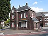
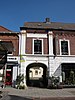
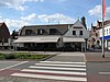
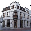
| Woning
|
±1910
|
|
Bassin 16
|
51° 15′ 25″ NB, 5° 42′ 16″ OL
|
0988/WN041
|
|
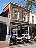
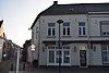
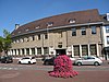
| Horeca / woning
|
|
J. Rouleau
|
Beekstraat 13
|
51° 15′ 17″ NB, 5° 42′ 22″ OL
|
0988/WN042
|
|
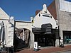
| Woonhuis
|
|
|
Beekstraat 55
|
51° 15′ 21″ NB, 5° 42′ 20″ OL
|
0988/WN043
|
|
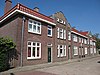
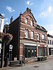
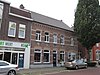
| Woningbouwcomplex van zes woningen
|
±1920
|
|
Begijnenhofstraat 1 t/m 11
|
51° 15′ 10″ NB, 5° 42′ 38″ OL
|
0988/WN044
|
|
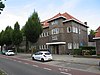
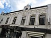
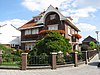
| Villa met kantoorruimte in traditionele bouwtrant
|
1924
|
Ir. C. Geenen (Eindhoven)
|
Biest 2
|
51° 15′ 22″ NB, 5° 42′ 34″ OL
|
0988/WN045
|
|
| Terrein Voorburcht, gracht en schootsvelden
|
±1432
|
|
Biest 3
|
51° 15′ 10″ NB, 5° 42′ 38″ OL
|
0988/WN046
|
Upload foto
|
| Herenhuis
|
1914
|
J. Rouleau
|
Biest 4
|
51° 15′ 22″ NB, 5° 42′ 35″ OL
|
0988/WN047
|
|
| Herenhuis
|
1914
|
J. Rouleau
|
Biest 6
|
51° 15′ 22″ NB, 5° 42′ 35″ OL
|
0988/WN048
|
|
| Vrijstaand woonhuis
|
1935
|
P. Stultiëns
|
Biest 13
|
51° 15′ 27″ NB, 5° 42′ 40″ OL
|
0988/WN049
|
|
| Woonhuis
|
1902
|
H. Smeets
|
Biest 14a
|
51° 15′ 24″ NB, 5° 42′ 37″ OL
|
0988/WN050
|
|
| Vrijstaand woonhuis
|
1935
|
P.H. Weegels
|
Biest 15
|
51° 15′ 27″ NB, 5° 42′ 41″ OL
|
0988/WN051
|
|
| Vrijstaand woonhuis
|
1934
|
P. Stultiëns
|
Biest 17
|
51° 15′ 28″ NB, 5° 42′ 41″ OL
|
0988/WN052
|
|
| Vrijstaand woonhuis
|
1934
|
J.M. Stals
|
Biest 19
|
51° 15′ 28″ NB, 5° 42′ 41″ OL
|
0988/WN053
|
|
| Twee halfvrijstaande woonhuizen
|
1933
|
P. Stultiëns
|
Biest 21
|
51° 15′ 28″ NB, 5° 42′ 42″ OL
|
0988/WN054
|
|
| Twee halfvrijstaande woonhuizen
|
1933
|
P. Stultiëns
|
Biest 23
|
51° 15′ 28″ NB, 5° 42′ 42″ OL
|
0988/WN055
|
|
| Woonhuis
|
1924
|
P. Stultiëns
|
Biest 27
|
51° 15′ 29″ NB, 5° 42′ 43″ OL
|
0988/WN056
|
|
| Dubbel woonhuis
|
1925
|
|
Biest 35 en 35a
|
51° 15′ 30″ NB, 5° 42′ 44″ OL
|
0988/WN057
|
|
| Dubbel woonhuis
|
1925
|
|
Biest 35b en 35c
|
51° 15′ 30″ NB, 5° 42′ 44″ OL
|
0988/WN058
|
|
| Twee samengevoegde arbeiderswoningen
|
eind 19e eeuw
|
|
Biest 48
|
51° 15′ 26″ NB, 5° 42′ 41″ OL
|
0988/WN059
|
|
| Twee arbeiderswoningen
|
1918
|
|
Biest 50-52
|
51° 15′ 27″ NB, 5° 42′ 41″ OL
|
0988/WN060
|
|
| Halfvrijstaand woonhuis
|
1936
|
P. Stultiëns
|
Biest 53
|
51° 15′ 36″ NB, 5° 42′ 49″ OL
|
0988/WN061
|
|
| Voormalige boerderij
|
1756 / 1835
|
|
Biest 56
|
51° 15′ 27″ NB, 5° 42′ 43″ OL
|
0988/WN062
|
|
| Herenhuis
|
1910
|
|
Biest 66
|
51° 15′ 29″ NB, 5° 42′ 45″ OL
|
0988/WN063
|
|
| Herenhuis
|
1910
|
|
Biest 68
|
51° 15′ 29″ NB, 5° 42′ 45″ OL
|
0988/WN064
|
|
| Dubbelpand voorheen Charitas-huis
|
1906 / 1936
|
|
Biest 70 en 74, Charitashof 30
|
51° 15′ 29″ NB, 5° 42′ 46″ OL
|
0988/WN065
|
|
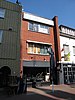
| Horeca
|
2e helft 17e eeuw
|
|
Biest 80
|
51° 15′ 30″ NB, 5° 42′ 46″ OL
|
0988/WN068
|
|
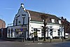
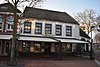
| Voormalige brouwerij en mouterij, nu café
|
1623 / eind 19e eeuw
|
|
Biest 112 en 112a
|
51° 15′ 36″ NB, 5° 42′ 49″ OL
|
0988/WN069
|
|
| Veldkruis
|
|
|
Blaakvenweg – Geuzendijk
|
51° 15′ 31″ NB, 5° 38′ 51″ OL
|
0988/WN071
|
Upload foto
|
| Romp Boonesmolen
|
|
|
Bonesmolen 2
|
51° 14′ 51″ NB, 5° 42′ 16″ OL
|
0988/WN072
|
|
| Bakhuis
|
|
|
Breijbaan 38
|
51° 14′ 18″ NB, 5° 45′ 12″ OL
|
0988/WN073
|
Upload foto
|
| Boerderij
|
|
|
Castertweg 2 ongenummerd
|
|
0988/WN074
|
Upload foto
|
| Woningen
|
1928
|
|
Coenraad Abelsstraat 17 t/m 25
|
51° 15′ 12″ NB, 5° 42′ 1″ OL
|
0988/WN075
|
|
| OLV van Fatimakerk[1] |
1955
|
P. Weegels
|
Coenraad Abelsstraat 31 a
|
51° 15′ 10″ NB, 5° 41′ 58″ OL
|
0988/WN076
|
Meer afbeeldingen
|
| Paterskapel / moskee[2] |
1911
|
P. Cuypers jr.
|
Coenraad Abelsstraat 36 b
|
51° 15′ 10″ NB, 5° 41′ 57″ OL
|
0988/WN077
|
|
| Voormalige boerderij
|
|
|
Dijkerakkerweg 5
|
51° 13′ 48″ NB, 5° 42′ 26″ OL
|
0988/WN078
|
|
| Boerderij
|
|
|
Dijkerstraat 34
|
51° 13′ 50″ NB, 5° 41′ 56″ OL
|
0988/WN079
|
Upload foto
|
| Boerderij
|
|
|
Dijkerstraat 36
|
51° 13′ 50″ NB, 5° 41′ 50″ OL
|
0988/WN080
|
Upload foto
|
| Boerderij
|
|
|
Dijkerstraat 40
|
51° 13′ 51″ NB, 5° 41′ 45″ OL
|
0988/WN081
|
Upload foto
|
| Boerderij
|
|
|
Dijkerstraat 42
|
51° 13′ 52″ NB, 5° 41′ 41″ OL
|
0988/WN082
|
Upload foto
|
| Vm Dienstwoning spoorw
|
|
|
Drakestijn 2
|
|
0988/WN083
|
Upload foto
|
| Bakhuis
|
|
|
Dupesweg 1
|
51° 13′ 0″ NB, 5° 45′ 14″ OL
|
0988/WN084
|
Upload foto
|
| Zuidwestelijke zijgevel boerderij
|
|
|
Eindhovenseweg 130
|
51° 16′ 9″ NB, 5° 40′ 50″ OL
|
0988/WN085
|
Upload foto
|
| Bakhuis
|
|
|
Eindhovenseweg 130
|
51° 16′ 9″ NB, 5° 40′ 50″ OL
|
0988/WN086
|
Upload foto
|
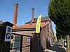
| Voorm. brouwerij
|
|
|
Emmasingel 12
|
51° 15′ 10″ NB, 5° 42′ 34″ OL
|
0988/WN087
|
|
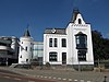
| “Walburg”
|
|
|
Emmasingel 32
|
51° 15′ 6″ NB, 5° 42′ 30″ OL
|
0988/WN088
|
|
| St. Martinusschool
|
|
|
Emmasingel 37
|
51° 15′ 13″ NB, 5° 42′ 36″ OL
|
0988/WN089
|
|
| Woonhuis
|
|
|
Emmasingel 40
|
51° 15′ 5″ NB, 5° 42′ 26″ OL
|
0988/WN090
|
|
| Kantoor / woning
|
|
|
Emmasingel 55
|
51° 15′ 7″ NB, 5° 42′ 35″ OL
|
0988/WN091
|
|
| Woonhuis
|
|
|
Emmasingel 57
|
51° 15′ 6″ NB, 5° 42′ 34″ OL
|
0988/WN092
|
|
| Woonhuis
|
|
|
Emmasingel 59
|
51° 15′ 6″ NB, 5° 42′ 34″ OL
|
0988/WN093
|
|
| Villa
|
|
|
Emmasingel 85
|
51° 15′ 4″ NB, 5° 42′ 27″ OL
|
0988/WN094
|
|
| Woonhuis met praktijk
|
|
|
Emmasingel 93
|
51° 15′ 3″ NB, 5° 42′ 25″ OL
|
0988/WN095
|
|
| Heilig Hartbeeld
|
1921
|
A.F.H. Falise
|
Emmasingel ongenummerd
|
51° 15′ 4″ NB, 5° 42′ 23″ OL
|
0988/WN096
|
|
| Veldkruis
|
|
|
Geuzendijk bij gemeentegrens
|
|
0988/WN097
|
Upload foto
|
| Boerderij
|
|
|
Grootvenweg 1
|
51° 13′ 43″ NB, 5° 42′ 24″ OL
|
0988/WN098
|
Upload foto
|
| Veldkruis
|
|
|
Heerweg 17
|
51° 16′ 17″ NB, 5° 43′ 3″ OL
|
0988/WN099
|
Upload foto
|
| Bedrijfspand
|
|
|
Hegstraat 4
|
51° 15′ 16″ NB, 5° 42′ 24″ OL
|
0988/WN100
|
|
| Boerderijen en kapelletjes etc.
|
|
|
Heijenroth “de Hei” gehucht
|
|
0988/WN101
|
Upload foto
|
| Woning / praktijkruimte
|
eind 18e eeuw
|
|
Hoogstraat 15
|
51° 15′ 17″ NB, 5° 42′ 27″ OL
|
0988/WN102
|
|
| Herenhuis
|
eind 18e eeuw
|
|
Hoogstraat 22
|
51° 15′ 17″ NB, 5° 42′ 28″ OL
|
0988/WN103
|
|
| Woonhuis
|
eind 18e eeuw
|
|
Hoogstraat 27
|
51° 15′ 18″ NB, 5° 42′ 29″ OL
|
0988/WN104
|
|
| Winkel / woning
|
eind 18e eeuw
|
|
Hoogstraat 28
|
51° 15′ 18″ NB, 5° 42′ 29″ OL
|
0988/WN105
|
|
| Winkel / woning
|
midden 18e eeuw
|
|
Hoogstraat 29
|
51° 15′ 18″ NB, 5° 42′ 29″ OL
|
0988/WN106
|
|
| Woonhuis
|
1777 / 1880 /1980
|
|
Hoogstraat 32, Oelemarkt 2
|
51° 15′ 18″ NB, 5° 42′ 29″ OL
|
0988/WN107
|
|
| Boerderij
|
±1830
|
|
Hulsterdijk 10
|
51° 15′ 27″ NB, 5° 40′ 44″ OL
|
0988/WN108
|
Upload foto
|
| Boerderij
|
1779
|
|
Hushoverweg 77b
|
51° 15′ 55″ NB, 5° 41′ 30″ OL
|
0988/WN109
|
Upload foto
|
| Veldkruis
|
|
|
Kerkveldweg – Molensteeg
|
51° 12′ 28″ NB, 5° 43′ 23″ OL
|
0988/WN111
|
Upload foto
|
| Voormalige ‘De Gruyter’-winkel / woning
|
1934
|
|
Korenmarkt 1-2
|
51° 15′ 14″ NB, 5° 42′ 25″ OL
|
0988/WN112
|
|
| Voormalige ‘De Gruyter’-winkel / woning
|
1934
|
|
Korenmarkt 3 – 3a
|
51° 15′ 14″ NB, 5° 42′ 25″ OL
|
0988/WN113
|
|
| Vm. waag nu kantoor
|
1920
|
|
Langpoort 1
|
51° 15′ 3″ NB, 5° 42′ 22″ OL
|
0988/WN114
|
|
| Winkel / woning
|
18e eeuw
|
|
Langstraat 4
|
51° 15′ 11″ NB, 5° 42′ 23″ OL
|
0988/WN115
|
|
| Winkel / woning
|
|
|
Langstraat 9
|
51° 15′ 10″ NB, 5° 42′ 24″ OL
|
0988/WN116
|
Upload foto
|
| Winkel / woning
|
|
|
Langstraat 19
|
51° 15′ 8″ NB, 5° 42′ 23″ OL
|
0988/WN117
|
|
| Detailhandel
|
|
|
Langstraat 20B-H,M
|
51° 15′ 9″ NB, 5° 42′ 22″ OL
|
0988/WN118
|
|
| Winkel / woning
|
|
|
Langstraat 41
|
51° 15′ 6″ NB, 5° 42′ 22″ OL
|
0988/WN119
|
|
| Winkel / woning
|
|
|
Langstraat 46
|
51° 15′ 5″ NB, 5° 42′ 20″ OL
|
0988/WN120
|
|
| Winkel / woning
|
|
|
Langstraat 47
|
51° 15′ 5″ NB, 5° 42′ 21″ OL
|
0988/WN121
|
|
| Winkel / woning
|
|
|
Langstraat 48
|
51° 15′ 5″ NB, 5° 42′ 20″ OL
|
0988/WN122
|
|
| Winkel / woning
|
|
|
Langstraat 49/49a
|
51° 15′ 5″ NB, 5° 42′ 21″ OL
|
0988/WN123
|
|
| Woonhuizen
|
|
|
Looimolenstraat 2 t/m 10
|
51° 15′ 10″ NB, 5° 42′ 11″ OL
|
0988/WN124
|
|
| Woonhuizen
|
|
|
Looimolenstraat 23 t/m 59
|
51° 15′ 10″ NB, 5° 42′ 6″ OL
|
0988/WN066
|
|
| Bakhuis
|
|
|
Lutenakkersteeg 2
|
51° 15′ 8″ NB, 5° 40′ 42″ OL
|
0988/WN125
|
Upload foto
|
| Boerderij
|
|
|
Lutenakkersteeg 3
|
51° 15′ 9″ NB, 5° 40′ 39″ OL
|
0988/WN126
|
Upload foto
|
| Boerderij
|
|
|
Maaseikerweg 200
|
51° 14′ 3″ NB, 5° 43′ 16″ OL
|
0988/WN127
|
Upload foto
|
| Boerderij en schuur
|
|
|
Maasenweg 16
|
51° 15′ 51″ NB, 5° 42′ 6″ OL
|
0988/WN128
|
Upload foto
|
| Winkel / woning
|
|
|
Maaspoort 2
|
51° 15′ 7″ NB, 5° 42′ 36″ OL
|
0988/WN129
|
|
| Winkel / woning
|
|
|
Maaspoort 17
|
51° 15′ 7″ NB, 5° 42′ 39″ OL
|
0988/WN130
|
|
| Kantoor/woningen
|
|
|
Maaspoort 18 – 20
|
51° 15′ 6″ NB, 5° 42′ 39″ OL
|
0988/WN131
|
|
| Winkel / woning
|
|
|
Maaspoort 19
|
51° 15′ 7″ NB, 5° 42′ 40″ OL
|
0988/WN132
|
|
| Winkel / woning
|
|
|
Maaspoort 24
|
51° 15′ 6″ NB, 5° 42′ 41″ OL
|
0988/WN133
|
|
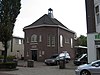
| Ned. Hervormde Bethelkerk[3] |
1912
|
G.W. Heukelom
|
Maaspoort 30
|
51° 15′ 5″ NB, 5° 42′ 42″ OL
|
0988/WN134
|
|
| Winkel / woning
|
|
|
Maasstraat 2
|
51° 15′ 11″ NB, 5° 42′ 24″ OL
|
0988/WN135
|
|
| Winkel / woning
|
|
|
Maasstraat 3
|
51° 15′ 11″ NB, 5° 42′ 25″ OL
|
0988/WN136
|
|
| Winkel / woning
|
|
|
Maasstraat 4
|
51° 15′ 11″ NB, 5° 42′ 24″ OL
|
0988/WN137
|
|
| Woning
|
|
|
Maasstraat 9
|
51° 15′ 11″ NB, 5° 42′ 26″ OL
|
0988/WN138
|
|
| Woning
|
|
|
Maasstraat 11
|
51° 15′ 11″ NB, 5° 42′ 27″ OL
|
0988/WN139
|
|
| Woning
|
|
|
Maasstraat 13
|
51° 15′ 10″ NB, 5° 42′ 27″ OL
|
0988/WN140
|
|
| Kantoor / woning
|
|
|
Maasstraat 14
|
51° 15′ 10″ NB, 5° 42′ 26″ OL
|
0988/WN141
|
|
| Pastorie
|
|
|
Maasstraat 15
|
51° 15′ 10″ NB, 5° 42′ 28″ OL
|
0988/WN142
|
|
| Vm. woonhuis
|
|
|
Maasstraat 18
|
51° 15′ 10″ NB, 5° 42′ 28″ OL
|
0988/WN143
|
|
| Winkel / woning
|
|
|
Maasstraat 26
|
51° 15′ 9″ NB, 5° 42′ 29″ OL
|
0988/WN144
|
|
| Kantoor / woning
|
|
|
Maasstraat 28
|
51° 15′ 9″ NB, 5° 42′ 30″ OL
|
0988/WN146
|
|
| Horeca / woning
|
|
|
Maasstraat 46
|
51° 15′ 8″ NB, 5° 42′ 34″ OL
|
0988/WN147
|
|
| Winkel / woning
|
|
|
Markt 17
|
51° 15′ 15″ NB, 5° 42′ 23″ OL
|
0988/WN148
|
|
| Horeca / woning
|
|
|
Markt 21
|
51° 15′ 15″ NB, 5° 42′ 24″ OL
|
0988/WN149
|
|
| Winkel / woning
|
|
|
Muntpromenade 2
|
51° 15′ 15″ NB, 5° 42′ 22″ OL
|
0988/WN150
|
|
| Gymzalen Boosten
|
|
|
Nelissenhofweg 1
|
51° 14′ 39″ NB, 5° 41′ 6″ OL
|
0988/WN151
|
|
| Horeca / woning
|
1777
|
|
Oelemarkt 4
|
51° 15′ 18″ NB, 5° 42′ 30″ OL
|
0988/WN152
|
|
| Vm. koetshuis nr. 10, nu café
|
1888
|
|
Oelemarkt 8
|
51° 15′ 18″ NB, 5° 42′ 31″ OL
|
0988/WN153
|
Meer afbeeldingen
|
| Horeca / bovenwoning
|
midden 19e eeuw
|
|
Oelemarkt 9
|
51° 15′ 19″ NB, 5° 42′ 30″ OL
|
0988/WN154
|
|
| Restaurant / bovenwoning
|
1884
|
|
Oelemarkt 12
|
51° 15′ 20″ NB, 5° 42′ 31″ OL
|
0988/WN155
|
|
| Horeca / woning
|
1e helft 18e eeuw
|
|
Oelemarkt 13
|
51° 15′ 20″ NB, 5° 42′ 30″ OL
|
0988/WN156
|
|
| Winkel / woning
|
begin 19e eeuw
|
|
Oelemarkt 15
|
51° 15′ 21″ NB, 5° 42′ 30″ OL
|
0988/WN157
|
|
| Voormalige brouwerij, nu horeca
|
18e eeuw
|
|
Oelemarkt 17
|
51° 15′ 21″ NB, 5° 42′ 30″ OL
|
0988/WN158
|
|
| Horeca / b&b
|
1775
|
|
Oelemarkt 22
|
51° 15′ 21″ NB, 5° 42′ 31″ OL
|
0988/WN159
|
|
| Straatwand
|
|
|
Oudkerkhof
|
51° 15′ 12″ NB, 5° 42′ 29″ OL
|
0988/WN160
|
|
| Voorm. pakhuis
|
|
|
Paradijsstraatje 47-49
|
51° 15′ 7″ NB, 5° 42′ 28″ OL
|
0988/WN161
|
|
| Veldkruis
|
|
|
Pelmersheideweg bij nr. 16
|
|
0988/WN162
|
Upload foto
|
| Museum
|
|
|
Recollectenstraat 5- 5a
|
51° 15′ 29″ NB, 5° 42′ 34″ OL
|
0988/WN163
|
|
| Boerderij
|
|
|
Roermondseweg 149
|
51° 14′ 51″ NB, 5° 44′ 47″ OL
|
0988/WN164
|
Upload foto
|
| Woonhuis
|
|
|
Roermondseweg 151
|
51° 14′ 50″ NB, 5° 44′ 47″ OL
|
0988/WN165
|
Upload foto
|
| Voormalige boerderij
|
|
|
Schonkenstraat 3
|
51° 16′ 19″ NB, 5° 42′ 21″ OL
|
0988/WN166
|
Upload foto
|
| Herenhuis
|
1870
|
|
Schoolstraat 10
|
51° 15′ 16″ NB, 5° 42′ 30″ OL
|
0988/WN167
|
|
| Voormalige stadsboerderij
|
midden 18e eeuw
|
|
Schoolstraat 20
|
51° 15′ 18″ NB, 5° 42′ 31″ OL
|
0988/WN169
|
|
| Woonhuis
|
|
|
Sint Hieronymusstraat 1
|
51° 15′ 4″ NB, 5° 42′ 30″ OL
|
0988/WN170
|
|
| Bakhuis
|
|
|
Sint Sebastiaanskapelstraat t.o. 36
|
|
0988/WN171
|
Upload foto
|
| Horeca / kantoor / woningen
|
|
|
Stationsplein 1, 3 en 5
|
51° 14′ 58″ NB, 5° 42′ 15″ OL
|
0988/WN172
|
|
| Vm hotel
|
|
|
Stationsstraat 7
|
51° 15′ 2″ NB, 5° 42′ 18″ OL
|
0988/WN173
|
|
| Horeca / woning
|
|
|
Stationsstraat 20
|
51° 14′ 60″ NB, 5° 42′ 15″ OL
|
0988/WN174
|
|
| Woning (Pandje Poell)
|
|
|
Walburgpassage 50
|
51° 15′ 9″ NB, 5° 42′ 25″ OL
|
0988/WN175
|
|
| Veldkruis
|
|
|
Wijffelterbroekdijk t.o. nr. 4
|
|
0988/WN176
|
Upload foto
|
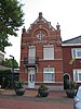
| Postkantoor
|
|
|
Wilhelminasingel 10
|
51° 15′ 5″ NB, 5° 42′ 17″ OL
|
0988/WN177
|
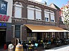
|
| Horeca
|
|
|
Wilhelminasingel 276
|
51° 15′ 23″ NB, 5° 42′ 16″ OL
|
0988/WN178
|
|


Recent Comments