Urban regulation plan Bielsko – Wikipedia, Free Encyclopedia
Urban regulation plan Bielsko -regulatory plan developed by Maks Fabiani, a Slovenian-Italian architect and urban planner, in 1898–1899 at the request of the Bielsko City Council (today’s Bielsko-Biała). He set the directions of spatial development of the city in the 20th century, while establishing significant changes in the existing spatial system (e.g. separation of building zones) and communication (including the construction of beltways or “straightening of curves”). Some of the plan’s assumptions were implemented only in the interwar period or even after World War II, and some have never been implemented.
The expansion of the industry resulted in increased urbanization of Bielsko. After opening in 1890 a new railway station, located on the northern outskirts of the city, the Dolne Przedmieście began to grow in this direction, covering the area over the 1860 Niper stream. Numerous schools, public buildings, bourgeois tenements, villas of the richest industrialists, new sacred buildings, and the dirt road leading towards the new station began to be built. The new buildings were modeled primarily on the architecture of Vienna (hence the term Little Vienna – used by some first compared to the Lower Przedmieście, then to all of Bielsko [first] ).
At the end of the nineteenth century, it was necessary to determine the directions of further spatial development of the city, regulate the communication routes and set new thoroughfares to unload traffic. To this end, in the years 1893–1894, geodetic measurements, led by Józef Höltschel, a retired professor of Vienna polytechnics, began. After Höltschel’s death in 1894, these works were suspended. A few years later, the City Council decided to organize the urban planning of Bielsko, inviting Franciszek von Gruber and Camilla Sitti as professional advisers, known by Austrian urban planners. They prepared a preliminary sketch of the regulatory plan, postulating “carry out the whole action in a more in -depth and studied manner” . The direct originator of the regulation of the urban planning of Bielsko was an industrialist, social activist and local politician, Gustaw Josephy.
In March 1898, work began on the overall urban regulation plan of Bielsko. This task was entrusted to Maks Fabianie, a Slovenian-Italian architect and urbanist, who in the same year published the regulatory plan of Ljubljana, destroyed in 1895 by an earthquake. The first conceptual work was carried out from spring 1898. In December, individual parts were discussed at the meetings of the City Council and in January 1899 the agreed preliminary project was applied to the current city plan in the dimension of catastral measurements. In this way, the prepared plans in February were submitted to the City Council, which accepted them. Further work, this time in the field, was carried out from February to October 1899. The resulting further corrections were later applied to the General Plan. The completed version of the study was published in October that year in the brochure Explanation report on the general regulatory plans of the city of Bielitz by the city. Then for several months the plan was made available to city residents who could report objections, applications and corrections. The final version of the plan, significantly modified (see: Section Implementation) Compared to the original, appeared in print in the document of the City Council included in four parts regarding the detailed implementation of the plan.
The Bielsko urban regulation project consisted of 55 sections, covering two basic ranges of cases:
- ordering existing buildings
- Determining the city’s future development plan in two phases:
- Over the next ten years, making the necessary reconstruction of streets, removal of unnecessary streets, widening and leveling the others, construction of pavements and renovation works
- In the long run, the arrangement of the city’s spatial development directions in the 20th century, definition of future communication arteries, new districts with a specific architectural and urban layout
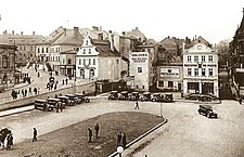
Fabiani was accepted by Töpferplatz as the central point of Bielsko (today pl. Brave ), from which the streets, including the main axis of the city-leading to the main railway station of Franz-Josef-Straße (today 3 house ) along with your extensions to the south, Schlossgraben (today Castle ) and Bleichstraße (today Partisans ). When preparing the plan, he was guided by the principle of protecting the historic substance and incorporating it into a new city layout by revealing some observation axes and creating new urban spaces without violating historical buildings, especially within the Old Town. He also sought to straighten street curvatures and reduce too sharp declines of the area (Śródmieście is spread on numerous hills). For this purpose, he designed, for example, the Old Town bypass – the road connecting Töpferplatz with Kaiserstraße (today Cieszyn ) bypassing the old town located much higher. At the same time, all communication arteries were to correspond with the road system of the neighboring white, forming de facto with Bielsko one urban organism (formally only from 1951). To discharge the cruising traffic, two beltways were designed:
- Internal running from the main railway station west to the Upper Przedmieście (today’s ul. Piastowska) and further south along Schneidergasse (today Wyspiański ) and Parkstraße (today November ) to the vicinity of Maisengrund and Berggasse in Żywiec Przedmieście, i.e. today’s ul. Sikornik and Michałowicz
- Outdoor running from the main railway station northwest, then along the northern border of the city based on the railway line to Cieszyn and: Luschkagasse streets (today Wita Stwosza ), Salzgasse (today Solna ) and Kudlichgasse (today Of the Blessed Virgin Mary Queen of Poland ) on the then western periphery, connecting to the internal beltway in the Maisergrund region (today Sikrnik )
The project also assumed the creation of staircases and pedestrian passes in places of particularly strong declines of the area: from Bleichstraße to Purzelberg Street (today Lompy ) and between Franz-Josef-Straße and Bahnstraße (today Barlicki ) and widening the stairs forming the eastern part of Staffelgasse (today Stair ). Fabiani also postulated the creation of a bridge on Biała connecting Börsenplatz (today pl. Tarry ) with Augasse (today Stojałowski ), Bialski Boulevard along the Niwka River, which should be channeled (and Augasse transformed into a street for traffic).
The Bielsko regulatory project assumed the division of the city into five building zones:
- The Old Town should preserve its historic urban layout and historical architecture. Thus, the modern buildings in this area should be strongly limited or completely eliminated.
- Areas between the railway station in the north, Schieshausstraße (today Słowacki in the west, Gustaw-Josephy-Platz (today pl. Żwirki and Wigury ) in the south and the White River in the east and along Josefstraße (today Sobieski ) and Kaiserstraße (today Cieszyn ) should have dense, compact buildings created primarily by tenement houses and public buildings.
- A mixed, residential and industrial zone should be created by Żywieckie Przedmieście and the area north of the inner beltway
- The strictly industrial zone should include the hazel district and northern suburbs located along the railway lines to Krakow, Katowice and Cieszyn.
- The villa should be located in the upper suburbs, excluding Josef- and Kaiserstraße with the immediate vicinity.
In theory, the project assumed the city’s radial development system, which would grow brilliantly from the center, along the network of streets running straight towards the outer direction and crossed with the circular beltways. This concept, based on the designs of Otto Wagner (whose Fabiani was a student) and his Vienna regulation plan, allowed unlimited possibilities of spatial development as a result of extending radial artery and adding new beltways.
Fabiani also devoted a lot of attention to park and city greenery. In the place intended to close the cemeteries: Old Evangelical (closed in 1911, but never closed) and Catholic at the church of St. The Trinity (liquidated in 1899) predicted city parks. He also in favor of enlargement of the city park and the creation of a wooded promenade along Biała. He also proposed park areas in the Mühlgasse region (today Mill ) and Rotenturmstraße (today Batory ). At the same time, he postulated the liquidation of the castle gardens existing from 1489 located between the Sułkowski castle and Biała and the construction of a modern residential district in their place.
In addition, he proposed the expansion of the church of St. Mikołaj or the construction of a new parish Catholic Church due to the fact that the medieval temple existing in the unchanged shape from the mid -eighteenth century did not meet the current needs. He also wanted to expand the workers’ district in Żywiec Przedmieście, at Berggasse (today Michałowicza ) and Kamitzgasse (today Tenement ) and construction of a workers’ hotel for five thousand places. The best known is, however, the project to rebuild Töpferplatz, recognized by Fabiani as the most important public space of Bielsko (which reflected the actual state of affairs), which was to be the Art Nouveau building of the town hall “About Florentine beautiful” .
The implementation of all the assumptions of the plan was calculated at 1,800,000 Austro-Hungarian crowns. It was one of the main causes of non -performance of the plan in its entirety – the amount was quickly reduced by nearly half, to 1,000,000 crowns. In addition, the project itself caused a lot of controversy. There were opinions that it was “Utopian” , “Thinking on some imaginary future” etc. The implementation of some demands was prevented by objections from residents to whom the plan was made available for inspection. Some of Fabiani’s projects have been modified.
Of the two designed beltways, only in 1913 the northern section of the internal beltway was built in 1913, which is today a fragment of ul. Piastowska. The main reason was too high costs of buying plots. After World War II, the Śródmieście bypass, without a connection with the nineteenth-century intentions of Fabiani or even without destiny as a beltway, but it was created-it created it extended to 2.5 km ul. Piastowska, fragment of al. Andersa and extended and elongated ul. Michałowicz (in the 19th century a small street of Berggasse); For subsequent projects (typical beltways), the Śródmiejska Western Bypass and “Nowopiekarska Street”, which is the northern Śródmieście bypass, only in the 21st century.
The construction of the Old Town bypass was never started and until the 1950s. Transit traffic towards Cieszyn took place through medieval streets of the Old Town. Niwka was channeled in 1913–1916, and the bridge connecting d. Börsenplatz (after 1918 pl. F. Smolki ) With the street created in this way, it was put into use in 1974 (without connection with the plan from 1899). Instead, the proposed stairs and pedestrian passership arose.
The postulated separation of building zones took place only partially. While the division into districts with a compact, villa and mixed is clearly visible to this day, the transfer of industrial plants outside the center only took place at the end of the 20th century.

Of the park’s assumptions designed by Fabiani, only the city park was enlarged. The castle gardens were liquidated in 1934–1937, a functionalist housing estate was created in their place.
St. Mikołaj, today’s cathedral, has been expanded in the neo-Gothic-modern style in 1909–1912. The workers ‘estate in Żywiec Przedmieście was expanded in 1911, but the designed workers’ hotel was not established. The largest of the projects was not implemented – the reconstruction of Töpferplatz (later bearing the name pl. Brave ), which, despite his meaning until 1938, did not have the western frontage (the one that according to Fabiani was to be occupied by the town hall).
- ↑ Cieszyn was also referred to as the “little Vienna” at that time.
- Urban ordering Bielsko and Max Fabiani’s plans. In: Ewa Chojecka: Architecture and urban planning of Bielsko-Biała until 1939. City as a work of art . Bielsko-Biała: Municipal Office in Bielsko-Biała, 1994, pp. 78–83, series: Bielsko-Biała Library. ISBN 83-901390-0-6 .
- Names of street and squares in Bielsko. In: Ewa Janoszek, Wojciech Kominiak: Bielsko-Biała and its surroundings on the former postcard in the times of the Second Polish Republic . Bielsko-Biała: WMW Mirosław Caputa, 2008, pp. 221–225. ISBN 978-83915603-1-0 . (source for nineteenth-century streets and squares)
Recent Comments