National Register of Historic Places listings in Marshall County, Tennessee
From Wikipedia, the free encyclopedia
Location of Marshall County in Tennessee
This is a list of the National Register of Historic Places listings in Marshall County, Tennessee.
This is intended to be a complete list of the properties and districts on the National Register of Historic Places in Marshall County, Tennessee, United States. Latitude and longitude coordinates are provided for many National Register properties and districts; these locations may be seen together in a map.[1]
There are 23 properties and districts listed on the National Register in the county.
This National Park Service list is complete through NPS recent listings posted April 14, 2023.[2]
Current listings[edit]
| [3] | Name on the Register[4] | Image | Date listed[5] | Location | City or town | Description |
|---|---|---|---|---|---|---|
| 1 | Joe Chase Adams House |
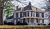 |
December 2, 1993 (#93001354) |
327 E. Church St. 35°26′59″N 86°47′02″W / 35.449722°N 86.783889°W |
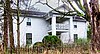
Lewisburg | |
| 2 | Baird-Welch House |
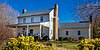 |
March 21, 1985 (#85000621) |
Water St. 35°21′43″N 86°50′18″W / 35.361944°N 86.838333°W |
Cornersville | |
| 3 | Bear Creek Cumberland Presbyterian Church |
 |
March 28, 1985 (#85000667) |
Bear Creek Rd. 35°25′23″N 86°55′55″W / 35.423056°N 86.931944°W |
Mooresville | |
| 4 | Belfast Railroad Depot |
 |
August 9, 1984 (#84003606) |
U.S. Route 431 35°25′12″N 86°42′07″W / 35.42°N 86.701944°W |
Belfast | |
| 5 | Berlin Historic District | August 30, 1984 (#84003609) |
U.S. Route 431 35°31′36″N 86°49′50″W / 35.526667°N 86.830556°W |
Berlin | ||
| 6 | Joseph Brittain House |
 |
March 17, 1997 (#97000241) |
Junction of Thick and Sweeney Rds. 35°40′44″N 86°43′45″W / 35.678889°N 86.729167°W |
Thick | |
| 7 | Chapel Hill Cumberland Presbyterian Church |
 |
August 30, 1985 (#85001897) |
302 N. Horton Pkwy. 35°37′46″N 86°41′28″W / 35.629444°N 86.691111°W |
Chapel Hill | |
| 8 | Confederate Cemetery Monument |
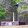 |
July 11, 2001 (#01000731) |
2279 TN-64 35°29′54″N 86°41′53″W / 35.498333°N 86.698056°W |
Lewisburg | |
| 9 | Cornersville Methodist Episcopal Church South |
 |
April 15, 1982 (#82003991) |
100 S. Mulberry St. 35°21′43″N 86°50′29″W / 35.361944°N 86.841389°W |
Cornersville | |
| 10 | Dixie Theatre | October 28, 2021 (#100007126) |
110 West Church St. 35°27′00″N 86°47′18″W / 35.4501°N 86.7883°W |
Lewisburg | ||
| 11 | Ewing Farm |
 |
April 5, 1984 (#84003612) |
1498 New Columbia Hwy. 35°28′47″N 86°47′58″W / 35.479722°N 86.799444°W |
Lewisburg | |
| 12 | Fitzpatrick House |
 |
August 26, 1982 (#82003992) |
810 Fitzpatrick Rd. 35°26′30″N 86°54′54″W / 35.441667°N 86.915°W |
Culleoka | |
| 13 | Nathan Bedford Forrest Boyhood Home |
 |
July 13, 1977 (#77001280) |
1435 Dean Rd 35°38′25″N 86°45′02″W / 35.640278°N 86.750556°W |
Chapel Hill | |
| 14 | Robert C. Harris House |
 |
January 27, 1983 (#83003051) |
3107 Old Columbia Rd. 35°30′08″N 86°52′29″W / 35.502222°N 86.874722°W |
South Berlin | |
| 15 | Ladies Rest Room |
 |
November 29, 1995 (#95001380) |
105 1st Ave., N. 35°26′45″N 86°46′57″W / 35.445833°N 86.7825°W |
Lewisburg | |
| 16 | Lillard’s Mill Hydroelectric Station |
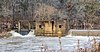 |
April 20, 1990 (#89002370) |
Milltown Rd. Boat Ramp Duck River 35°34′59″N 86°46′48″W / 35.583056°N 86.78°W |
Milltown | |
| 17 | Palmetto Farm |
 |
March 28, 1985 (#85000675) |
2935 Shelbyville Hwy. State Route 64 35°29′28″N 86°39′49″W / 35.491111°N 86.663611°W |
Bedford | Extends into Bedford County |
| 18 | Presbyterian Church, U.S.A. |
 |
November 27, 2019 (#100004693) |
300 Water St. 35°27′04″N 86°47′25″W / 35.4511°N 86.7902°W |
Lewisburg | |
| 19 | Swaim House |
|
July 12, 1984 (#84003613) |
200 N. Horton Pkwy 35°37′41″N 86°41′33″W / 35.62793°N 86.69249°W |
Chapel Hill | |
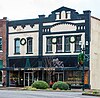
| 20 | J.C. Tate General Merchandise Store |
 |
July 12, 1978 (#78002608) |
1515 Fishing Ford Rd. 35°25′11″N 86°42′10″W / 35.419722°N 86.702778°W |
Belfast | |
| 21 | Valley Farm |
 |
April 5, 1984 (#84003616) |
1892 Cornersville Hwy. 35°23′28″N 86°49′11″W / 35.391111°N 86.819722°W |
Cornersville | |
| 22 | Verona Methodist Episcopal Church, South |
 |
November 7, 1985 (#85002755) |
724 John Lund Rd. 35°31′46″N 86°46′21″W / 35.529444°N 86.7725°W |
Lewisburg | Renamed Reformed Baptist Fellowship |
| 23 | WJJM Radio Station and Tower |
 |
July 10, 2017 (#100001304) |
344 E Church St. 35°27′01″N 86°47′01″W / 35.450155°N 86.783616°W |
Lewisburg |
See also[edit]
References[edit]
- ^ The latitude and longitude information provided in this table was derived originally from the National Register Information System, which has been found to be fairly accurate for about 99% of listings. Some locations in this table may have been corrected to current GPS standards.
- ^ National Park Service, United States Department of the Interior, “National Register of Historic Places: Weekly List Actions”, retrieved April 14, 2023.
- ^ Numbers represent an alphabetical ordering by significant words. Various colorings, defined here, differentiate National Historic Landmarks and historic districts from other NRHP buildings, structures, sites or objects.
- ^ “National Register Information System”. National Register of Historic Places. National Park Service. April 24, 2008.
- ^ The eight-digit number below each date is the number assigned to each location in the National Register Information System database, which can be viewed by clicking the number.
Recent Comments