Artux – Wikipedia
From Wikipedia, the free encyclopedia
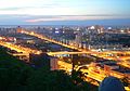
County-level city in Xinjiang, People’s Republic of China
Artux,[4]Artush[5][6] (Uyghur: ئاتۇش شەھىرى; Kyrgyz: ارتىش, Артыш, Artysh), and officially rendered as Atush (Chinese: 阿图什市; pinyin: Ātúshí Shì),[7] is a county-level city and the capital of the Kyrgyz autonomous prefecture of Kizilsu in Xinjiang, China. The government seat is in Guangminglu Subdistrict (光明路街道).[8]
History[edit]

In January 1943, Artux County was established.[1][9]
In June 1986, Artux County became Artux City.[1][9]
In 2018, the dome of Eshtachi Mosque (39°41′33.46″N 76°7′25.88″E / 39.6926278°N 76.1238556°E) was removed.[5][6] In recent times other mosques have been taken down too.
The Artux City Vocational Skills Education Training Service Center in Artux is one of the Xinjiang re-education camps.[10]
At 10:23 pm on January 19, 2020, a 5.2 magnitude earthquake struck in Artux.[4]
Geography and climate[edit]
It is situated in the northwest part of the Tarim Basin, south of the Tien Shan mountains. Like most of Xinjiang, Artux has a cool arid climate (Köppen BWk) with hot summers, freezing winters and little precipitation and low humidity year-round. The annual mean temperature is 13.1 °C (55.6 °F) and the annual mean precipitation around 95 millimetres or 3.74 inches. Most of this limited precipitation falls from erratic thunderstorms in the summer months, although at this time relative humidity averages less than 35 percent.
| Climate data for Artux (1981–2010 normals) | |||||||||||||
|---|---|---|---|---|---|---|---|---|---|---|---|---|---|
| Month | Jan | Feb | Mar | Apr | May | Jun | Jul | Aug | Sep | Oct | Nov | Dec | Year |
| Record high °C (°F) | 19.0 (66.2) |
18.6 (65.5) |
28.4 (83.1) |
34.9 (94.8) |
36.0 (96.8) |
39.5 (103.1) |
41.0 (105.8) |
41.8 (107.2) |
37.0 (98.6) |
30.9 (87.6) |
25.1 (77.2) |
18.9 (66.0) |
41.8 (107.2) |
| Average high °C (°F) | 0.3 (32.5) |
6.0 (42.8) |
14.4 (57.9) |
22.6 (72.7) |
27.6 (81.7) |
31.5 (88.7) |
33.5 (92.3) |
32.5 (90.5) |
27.7 (81.9) |
20.2 (68.4) |
10.8 (51.4) |
2.0 (35.6) |
19.1 (66.4) |
| Daily mean °C (°F) | −4.7 (23.5) |
−0.7 (30.7) |
9.0 (48.2) |
16.7 (62.1) |
21.5 (70.7) |
25.3 (77.5) |
27.1 (80.8) |
26.2 (79.2) |
21.3 (70.3) |
13.8 (56.8) |
4.9 (40.8) |
−2.8 (27.0) |
13.1 (55.6) |
| Average low °C (°F) | −8.8 (16.2) |
−4.2 (24.4) |
3.8 (38.8) |
10.9 (51.6) |
15.6 (60.1) |
19.1 (66.4) |
20.9 (69.6) |
20.0 (68.0) |
15.1 (59.2) |
7.7 (45.9) |
−0.2 (31.6) |
−6.6 (20.1) |
7.8 (46.0) |
| Record low °C (°F) | −20.5 (−4.9) |
−20.7 (−5.3) |
−7.9 (17.8) |
−0.1 (31.8) |
4.1 (39.4) |
8.1 (46.6) |
11.4 (52.5) |
11.5 (52.7) |
6.5 (43.7) |
−2.2 (28.0) |
−12.6 (9.3) |
−19.9 (−3.8) |
−20.7 (−5.3) |
| Average precipitation mm (inches) | 2.7 (0.11) |
4.9 (0.19) |
8.6 (0.34) |
6.4 (0.25) |
13.0 (0.51) |
12.3 (0.48) |
13.6 (0.54) |
13.5 (0.53) |
10.2 (0.40) |
6.7 (0.26) |
2.5 (0.10) |
2.4 (0.09) |
96.8 (3.8) |
| Average relative humidity (%) | 62 | 50 | 38 | 30 | 30 | 30 | 32 | 35 | 38 | 42 | 52 | 64 | 42 |
| Source: China Meteorological Administration[11] | |||||||||||||
Administrative divisions[edit]
Artux includes three subdistricts, one town, six townships and one other area:[12][1][13]
Subdistricts (يولى كوچا باشقارمىسى / 街道):
- Bext Avenue Subdistrict (Xingfu Lu; بەخت يولى كوچا باشقارمىسى / 幸福路街道), Nurluq Avenue Subdistrict (Guangming Lu; نۇرلۇق يولى كوچا باشقارمىسى / 光明路街道), Xincheng Subdistrict (新城街道)
Town (بازىرى / 镇):
Townships (يېزىسى / 乡):
- Süntag[14] (Songtake, Suntagh; سۇنتاغ يېزىسى / 松他克乡), Azak[14] (Azhake, Azaq; ئازاق يېزىسى / 阿扎克乡), Agu[14] (Ahu, Aghu; ئاغۇ يېزىسى / 阿湖乡), Katyaylak[14] (Gedaliang, Kattaylaq; كاتتايلاق يېزىسى / 格达良乡), Karajül[15] (Halajun, Karajol,[14] Qarajol; قاراجول يېزىسى / 哈拉峻乡),[16] Tugurmiti (Tugumaiti; تۈگۈرمىتى يېزىسى / 吐古买提乡)
Other areas:
- Bingtuan Nongsanshi Hongqi Farm (兵团农三师红旗农场)
The city had two subdistricts, five townships and three farms under its jurisdiction in 2018.
Economy[edit]
Artux’s economy is primarily agriculture, the agricultural products are mainly cotton, grapes, and sheep.
Industries in Artux include salt-making, cotton-ginning, food processing and cooking oil processing. Agricultural products include wheat, corn, sorghum, sesame, rice and others, and the local specialty is the common fig. Sheep are the main livestock in Artux.[9]
Demographics[edit]
| Year | Pop. | ±% p.a. |
|---|---|---|
| 2000 | 200,345 | — |
| 2010 | 240,368 | +1.84% |
| 2015 | 269,317 | +2.30% |
| [1][2] | ||
As of 1997[update], 81.5% of the population of Artux was Uyghur.[3]
As of 1999[update], 79.68% of the population of Artux was Uyghur and 7.21% of the population was Han Chinese.[17]
As of 2015[update], 216,651 (80.44%) of the 269,317 residents of Artux were Uyghur, 30,174 (11.20%) were Kyrgyz, 21,754 (8.08%) were Han Chinese and 738 were from other ethnic groups.[2]
Transportation[edit]
Artux is served by the Southern Xinjiang Railway.[9]
Notable persons[edit]
Historical maps[edit]
Historical English-language maps including Artux:
-

Map including Artux A-t’u-shih (DMA, 1983)
-
![Map including Artux (labeled as A-T'U-SHIH (ARTUSH)) (AMS, 1966)[a]](https://upload.wikimedia.org/wikipedia/commons/thumb/a/ae/Txu-oclc-6654394-nj-43-5th-ed.jpg/215px-Txu-oclc-6654394-nj-43-5th-ed.jpg)
Map including Artux (labeled as A-T’U-SHIH (ARTUSH)) (AMS, 1966)[a]
-
![From the Operational Navigation Chart; map including Artux (A-t'u-shih) (DMA, 1980)[b]](https://upload.wikimedia.org/wikipedia/commons/thumb/f/fb/Operational_Navigation_Chart_G-7%2C_6th_edition.jpg/331px-Operational_Navigation_Chart_G-7%2C_6th_edition.jpg)
From the Operational Navigation Chart; map including Artux (A-t’u-shih) (DMA, 1980)[b]
-
![Map including Artux (A-t'u-shih) (DMA, 1984)[c]](https://upload.wikimedia.org/wikipedia/commons/thumb/a/a1/Txu-pclmaps-oclc-22834566_g-7a.jpg/335px-Txu-pclmaps-oclc-22834566_g-7a.jpg)
Map including Artux (A-t’u-shih) (DMA, 1984)[c]
- ^ From map: “DELINEATION OF INTERNATIONAL BOUNDARIES MUST NOT BE CONSIDERED AUTHORITATIVE”
- ^ From map: “The representation of international boundaries is not necessarily authoritative.”
- ^ From map: “The representation of international boundaries is not necessarily authoritative”
References[edit]
- ^ a b c d e 阿图什市历史沿革 [Artux City Historical Development] (in Simplified Chinese). XZQH.org. 29 January 2015. Retrieved 6 August 2020.
2000年第五次人口普查,阿图什市常住总人口200345人,{…}2003年,全市总面积15697.78平方千米,{…}2010年第六次人口普查,阿图什市常住总人口240368人,其中:幸福路街道21786人,光明路街道36316人,松他克乡36849人,阿扎克乡38574人,阿湖乡16189人,上阿图什乡45847人,格达良乡16248人,哈拉峻乡15931人,吐古买提乡9009人,兵团农三师红旗农场3619人。
- ^ a b c 3-7 各地、州、市、县(市)分民族人口数 (in Simplified Chinese). شىنجاڭ ئۇيغۇر ئاپتونوم رايونى 新疆维吾尔自治区统计局 Statistic Bureau of Xinjiang Uygur Autonomous Region. Archived from the original on 2017-10-11. Retrieved 2017-09-03.
- ^ a b 1997年阿图什市行政区划 [1997 Artux City Administrative Divisions] (in Simplified Chinese). XZQH.org. 31 December 2010. Retrieved 7 August 2020.
克孜勒苏柯尔克孜自治州辖市,州府驻地。位于自治州西南部,与吉尔吉斯斯坦接壤。面积1.5万平方千米,人口18.4万,有柯尔克孜、维吾尔、汉、回、哈萨克、塔吉克等16个民族,其中维吾尔族占81.5%,辖2街道7乡。(本页根据《中国政区大典》整理,1997年左右资料)
- ^ a b Mu Xuequan, ed. (19 January 2020). “5.2-magnitude quake hits Xinjiang: CENC”. Xinhua News Agency. Archived from the original on September 29, 2021. Retrieved 6 August 2020.
the city of Artux in Kizilsu Kirgiz Autonomous Prefecture in northwest China’s Xinjiang Uygur Autonomous Region
- ^ a b Fred Hiatt (3 November 2019). “In China, every day is Kristallnacht”. The Washington Post. Retrieved 10 August 2020.
The dome of a Uighur mosque in Artush, Xinjiang, was removed in 2018.
- ^ a b Asim Kashgarian (1 December 2019). “US: China Targets Uighur Mosques to Eradicate Minority’s Faith”. Voice of America. Retrieved 11 August 2020.
Artush Eshtachi Grand Mosque is seen in Artush, in China’s northwest Xinjiang province.
10/8/2016 9/8/2018
39°41′33.46″N 76°7′25.88″E
Satellite imagery with a comparative analysis of Artush Eshtachi Mosque. - ^ The official spelling according to 中国地名录. Beijing: SinoMaps Press. 1997. ISBN 7-5031-1718-4.
- ^ 阿图什市概况. xzqh.org. 2015-01-29. Retrieved 2019-09-30.
- ^ a b c d Xia Zhengyi 夏征农; Chen Zhili 陈至立, eds. (September 2009). 辞海:第六版彩图本 [Cihai (Sixth Edition in Color)] (in Chinese). Shanghai: Shanghai Lexicographical Publishing House. p. 0017. ISBN 9787532628599.
- ^ Hannah Knowles, Kim Bellware and Lateshia Beachum (25 November 2019). “Secret documents detail inner workings of China’s mass detention camps for minorities”. The Washington Post. Retrieved 11 August 2020.
A guard tower and barbed wire fences are seen around a section of the Artux City Vocational Skills Education Training Service Center in Artux in western China’s Xinjiang region in December. This is one of a growing number of internment camps in the Xinjiang region.
{{cite news}}: CS1 maint: uses authors parameter (link) - ^ 中国气象数据网 – WeatherBk Data (in Chinese (China)). China Meteorological Administration. Retrieved 2020-04-15.
- ^ 2019年统计用区划代码和城乡划分代码:阿图什市 [2019 Statistical Area Numbers and Rural-Urban Area Numbers: Artux City] (in Simplified Chinese). National Bureau of Statistics of the People’s Republic of China. 2019. Retrieved 5 August 2020.
统计用区划代码 名称 653001001000 幸福路街道 653001002000 光明路街道 653001003000 新城街道 653001100000 上阿图什镇 653001200000 松他克乡 653001201000 阿扎克乡 653001202000 阿湖乡 653001204000 格达良乡 653001205000 哈拉峻乡 653001206000 吐古买提乡 653001500000 兵团农三师红旗农场
- ^ 阿图什市行政区划 (in Simplified Chinese). Artux People’s Government. 12 June 2019. Retrieved 6 August 2020.
阿图什市于1986年经国务院批准撤县设市,辖7乡、3场、2个街道办事处
- ^ a b c d e f Xie Yuzhong 解玉忠 (2003). 地名中的新疆 (in Simplified Chinese). Ürümqi: 新疆人民出版社. pp. 189–190. ISBN 7-228-08004-1.
- ^ Karajül (Approved – N) at GEOnet Names Server, United States National Geospatial-Intelligence Agency
- ^ 生物景观类 (in Simplified Chinese). Artux People’s Government. 12 June 2019. Retrieved 6 August 2020.
柳树林距哈拉峻乡政府驻地约26千米,占地数十亩。
- ^ Morris Rossabi, ed. (2004). Governing China’s Multiethnic Frontiers (PDF). University of Washington Press. p. 179. ISBN 0-295-98390-6.
- ^ 3-7 各地、州、市、县(市)分民族人口数 [3-7 Population by Nationality by Prefecture, State, City and County (City)]. tjj.xinjiang.gov.cn (in Chinese). Statistical Bureau of Xinjiang Uyghur Autonomous Region. 2020-06-10. Archived from the original on 2020-11-01. Retrieved 2021-06-11.
|
Links to related articles |
|||||||||||||||||||||||||||||||||||||||||||||||||||||||||||||||||||||||||||
|---|---|---|---|---|---|---|---|---|---|---|---|---|---|---|---|---|---|---|---|---|---|---|---|---|---|---|---|---|---|---|---|---|---|---|---|---|---|---|---|---|---|---|---|---|---|---|---|---|---|---|---|---|---|---|---|---|---|---|---|---|---|---|---|---|---|---|---|---|---|---|---|---|---|---|---|
|
|||||||||||||||||||||||||||||||||||||||||||||||||||||||||||||||||||||||||||


Recent Comments