Életot – Wikipedia
From Wikipedia, the free encyclopedia
Commune in Normandy, France
|
Életot |
|
|---|---|
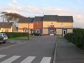
Town hall and post office |
|

Coat of arms |
|
|
Location of Életot  |
|


|
|
| Coordinates:
49°47′21″N 0°27′17″E / 49.7892°N 0.4547°ECoordinates: 49°47′21″N 0°27′17″E / 49.7892°N 0.4547°E |
|
| Country | France |
| Region | Normandy |
| Department | Seine-Maritime |
| Arrondissement | Le Havre |
| Canton | Fécamp |
| Intercommunality | CA Fécamp Caux Littoral |
| Area
1 |
6.81 km2 (2.63 sq mi) |
| Population | 643 |
| • Density | 94/km2 (240/sq mi) |
| Time zone | UTC+01:00 (CET) |
| • Summer (DST) | UTC+02:00 (CEST) |
| INSEE/Postal code | |
| Elevation | 0–118 m (0–387 ft) (avg. 100 m or 330 ft) |
| 1 French Land Register data, which excludes lakes, ponds, glaciers > 1 km2 (0.386 sq mi or 247 acres) and river estuaries. | |
Életot is a commune in the Seine-Maritime department in the Normandy region in northern France.
Geography[edit]
A farming village on the coast of the Pays de Caux, situated some 32 miles (51 km) northeast of Le Havre, on the D79 road. A pebble beach and spectacular limestone cliffs can be reached by way of the steps of the val d’Ausson.
Heraldry[edit]
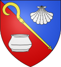 |
The arms of Életot are blazoned : Per bend sinister azure and gules, an abbot’s crozier Or bendwise sinister between an escallop and a roman vase argent. |
Population[edit]
| Year | Pop. | ±% p.a. |
|---|---|---|
| 1968 | 508 | — |
| 1975 | 516 | +0.22% |
| 1982 | 510 | −0.17% |
| 1990 | 552 | +0.99% |
| 1999 | 537 | −0.31% |
| 2007 | 600 | +1.40% |
| 2012 | 618 | +0.59% |
| 2017 | 645 | +0.86% |
| Source: INSEE[2] | ||
Places of interest[edit]
- The church of St.Pierre, dating from the seventeenth century.
See also[edit]
References[edit]
- ^
“Populations légales 2019”. The National Institute of Statistics and Economic Studies. 29 December 2021.
- ^ Population en historique depuis 1968, INSEE
Wikimedia Commons has media related to Életot.
Recent Comments