| [3] |
Name on the Register[4] |
Image
|
Date listed[5] |
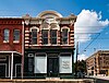
Location
|
City or town |
Description
|
| 1
|
Anderson Camp Ground
|
|
December 27, 1982
(#82001735)
|
W of Brushy Creek on Farm to Market Road 837
31°57′14″N 95°37′23″W / 31.953889°N 95.623056°W / 31.953889; -95.623056 (Anderson Camp Ground)
|
Brushy Creek |
also called Brushy Creek Arbor and United Methodist Church
|
| 2
|
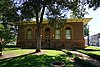
Anderson County Courthouse
|
|
September 28, 1992
(#92001256)
|
1 Public Sq.
31°45′54″N 95°37′34″W / 31.765°N 95.626111°W / 31.765; -95.626111 (Anderson County Courthouse)
|
Palestine |
Recorded Texas Historic Landmark
|
| 3
|
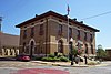
Anderson County Jail
|
|
June 11, 1998
(#98000692)
|
704 Avenue A
31°45′50″N 95°37′36″W / 31.763889°N 95.626667°W / 31.763889; -95.626667 (Anderson County Jail)
|
Palestine |
Historic and Architectural Resources of Palestine MPS
|
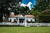
| 4
|
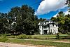
William and Caroline Broyles House
|
|
November 10, 1988
(#88002614)
|
1305 S. Sycamore St.
31°44′52″N 95°37′44″W / 31.747778°N 95.628889°W / 31.747778; -95.628889 (William and Caroline Broyles House)
|
Palestine |
Recorded Texas Historic Landmark
|
| 5
|
Denby Building
|
|
June 11, 1998
(#98000694)
|
201 W. Crawford St.
31°45′47″N 95°37′56″W / 31.763056°N 95.632222°W / 31.763056; -95.632222 (Denby Building)
|
Palestine |
Historic and Architectural Resources of Palestine MPS
|
| 6
|
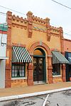
G. E. Dilley Building
|
|
June 11, 1998
(#98000698)
|
503 W. Main St.
31°45′44″N 95°38′05″W / 31.762222°N 95.634722°W / 31.762222; -95.634722 (G. E. Dilley Building)
|
Palestine |
Historic and Architectural Resources of Palestine MPS
|
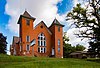
| 7
|
First Presbyterian Church
|
|
June 11, 1998
(#98000695)
|
406 Avenue A
31°45′45″N 95°37′44″W / 31.7625°N 95.628889°W / 31.7625; -95.628889 (First Presbyterian Church)
|
Palestine |
Recorded Texas Historic Landmark; Historic and Architectural Resources of Palestine MPS
|
| 8
|
Freeman Farm
|
|
June 12, 2000
(#00000656)
|
Co. Rd. 323, 3 miles SE of Frankston
31°59′38″N 95°29′53″W / 31.993889°N 95.498056°W / 31.993889; -95.498056 (Freeman Farm)
|
Frankston |
also called Kickapoo Farm, Freeman Plantation
|
| 9
|
Gatewood-Shelton Gin
|
|
June 3, 1998
(#98000637)
|
304 E. Crawford
31°45′50″N 95°37′41″W / 31.763889°N 95.628056°W / 31.763889; -95.628056 (Gatewood-Shelton Gin)
|
Palestine |
Historic and Architectural Resources of Palestine MPS
|
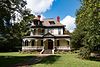
| 10
|
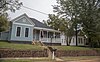
Howard House
|
|
March 14, 1993
(#93000072)
|
1011 N. Perry St.
31°46′11″N 95°37′34″W / 31.769722°N 95.626111°W / 31.769722; -95.626111 (Howard House)
|
Palestine |
Recorded Texas Historic Landmark; part of the North Side Historic District
|
| 11
|
Lincoln High School
|
Upload image
|
June 3, 1998
(#98000636)
|
920 W. Swantz St.
31°45′20″N 95°38′26″W / 31.755556°N 95.640556°W / 31.755556; -95.640556 (Lincoln High School)
|
Palestine |
Historic and Architectural Resources of Palestine MPS; burned in 1999, demolished.
|
| 12
|
Link House
|
|
May 29, 1980
(#80004073)
|
925 N. Link St.
31°46′06″N 95°37′46″W / 31.76847°N 95.6294°W / 31.76847; -95.6294 (Link House)
|
Palestine |
Part of the North Side Historic District; also called Link-Bunton House
|
| 13
|
Michaux Park Historic District
|
|
April 28, 2004
(#04000380)
|
Roughly bounded by S. Micheaux St., Jolly St., Crokett Rd., Rogers St., and E Park Ave.
31°45′16″N 95°37′32″W / 31.7545°N 95.6256°W / 31.7545; -95.6256 (Michaux Park Historic District)
|
Palestine |
Historic and Architectural Resources of Palestine MPS
|
| 14
|
Mount Vernon African Methodist Episcopal Church
|
|
June 3, 1998
(#98000635)
|
913 E. Calhoun St.
31°46′05″N 95°37′22″W / 31.768056°N 95.622778°W / 31.768056; -95.622778 (Mount Vernon African Methodist Episcopal Church)
|
Palestine |
Recorded Texas Historic Landmark; Historic and Architectural Resources of Palestine MPS
|
| 15
|
North Side Historic District
|
|
July 1, 1998
(#98000825)
|
Roughly bounded by Kolsted, N. Perry, W. Green, and N. Conrad Sts.
31°46′07″N 95°37′53″W / 31.768611°N 95.631389°W / 31.768611; -95.631389 (North Side Historic District)
|
Palestine |
Includes Recorded Texas Historic Landmarks; Historic and Architectural Resources of Palestine MPS
|
| 16
|
Old Town Residential Historic District
|
|
June 15, 2006
(#06000509)
|
Roughly surrounded by Lacey St.
31°46′02″N 95°37′22″W / 31.767222°N 95.622778°W / 31.767222; -95.622778 (Old Town Residential Historic District)
|
Palestine |
|
| 17
|
Pace McDonald Site
|
|
August 12, 1982
(#82004488)
|
Address restricted[6] |
Palestine |
Smithsonian trinomial 41AN51
|
| 18
|
Palestine Carnegie Library
|
|
October 17, 1988
(#88001944)
|
502 N. Queen St.
31°45′48″N 95°38′04″W / 31.763333°N 95.634444°W / 31.763333; -95.634444 (Palestine Carnegie Library)
|
Palestine |
Recorded Texas Historic Landmark
|
| 19
|
Palestine High School
|
|
September 24, 1986
(#86002295)
|
400 Micheaux Ave.
31°45′29″N 95°37′38″W / 31.758056°N 95.627222°W / 31.758056; -95.627222 (Palestine High School)
|
Palestine |
Recorded Texas Historic Landmark; currently the Museum for East Texas Culture
|
| 20
|
Palestine New Town Commercial Historic District
|
|
October 6, 2021
(#100007058)
|
Roughly bounded by North Queen, Crawford, North Houston, and Spring Sts.
31°45′44″N 95°37′57″W / 31.7622°N 95.6325°W / 31.7622; -95.6325 (Palestine New Town Commercial Historic District)
|
Palestine |
|
| 21
|
Post Office-Palestine
|
|
June 11, 1998
(#98000693)
|
101 E. Oak St.
31°45′46″N 95°37′52″W / 31.76281°N 95.63120°W / 31.76281; -95.63120 (Post Office-Palestine)
|
Palestine |
Historic and Architectural Resources of Palestine MPS
|
| 22
|
John H Reagan Monument
|
|
June 3, 1998
(#98000633)
|
Reagan Park; vicinity of Park and Crockett Sts.
31°45′28″N 95°37′31″W / 31.75781°N 95.62530°W / 31.75781; -95.62530 (John H Reagan Monument)
|
Palestine |
Historic and Architectural Resources of Palestine MPS
|
| 23
|
Redlands Hotel
|
|
June 3, 1998
(#98000634)
|
400 N. Queen St.
31°45′46″N 95°38′04″W / 31.76287°N 95.63436°W / 31.76287; -95.63436 (Redlands Hotel)
|
Palestine |
Historic and Architectural Resources of Palestine MPS
|
| 24
|
Robinson Bank Building
|
|
June 11, 1998
(#98000691)
|
213 W. Main St.
31°45′44″N 95°37′58″W / 31.762222°N 95.632778°W / 31.762222; -95.632778 (Robinson Bank Building)
|
Palestine |
Historic and Architectural Resources of Palestine MPS
|
| 25
|
Sacred Heart Catholic Church and School
|
|
December 6, 1979
(#79002909)
|
503 N. Queen St.
31°45′45″N 95°38′04″W / 31.7625°N 95.634444°W / 31.7625; -95.634444 (Sacred Heart Catholic Church and School)
|
Palestine |
Recorded Texas Historic Landmark
|
| 26
|
A. C. Saunders Site
|
|
July 15, 1982
(#82004487)
|
Address restricted[6] |
Frankston |
Smithsonian trinomial 41AN19
|
| 27
|
South Side Historic District
|
|
July 1, 1998
(#98000826)
|
Roughly bounded by W. Colorado, and S. Michaux Sts., and Union Pacific Railroad Tracks
31°45′21″N 95°37′50″W / 31.755833°N 95.630556°W / 31.755833; -95.630556 (South Side Historic District)
|
Palestine |
Includes Recorded Texas Historic Landmarks; Historic and Architectural Resources of Palestine MPS
|
| 28
|
Texas & Pacific Steam Locomotive No. 610
|
|
March 25, 1977
(#77001477)
|
Park Road 70
31°44′28″N 95°34′16″W / 31.74118°N 95.5712°W / 31.74118; -95.5712 (Texas & Pacific Steam Locomotive No. 610)
|
Palestine |
|


Recent Comments