National Register of Historic Places listings in Cape Girardeau County, Missouri


(#04000385)
37°18′04″N 89°31′09″W / 37.301111°N 89.519167°W / 37.301111; -89.519167 (B’Nai Israel Synagogue)
(#07000573)
37°24′43″N 89°26′16″W / 37.411944°N 89.437778°W / 37.411944; -89.437778 (Bainbridge Ferry)
(#07000577)
37°26′11″N 89°28′07″W / 37.436517°N 89.468747°W / 37.436517; -89.468747 (Bainbridge Ferry Rd.)


(#85000853)
37°22′54″N 89°39′56″W / 37.381667°N 89.665556°W / 37.381667; -89.665556 (Bennett-Tobler-Pace-Oliver House)
(#99001598)
37°21′49″N 89°41′26″W / 37.363611°N 89.690556°W / 37.363611; -89.690556 (Big Hill Farmstead Historic District)


(#15001017)
37°18′24″N 89°31′39″W / 37.306789°N 89.527404°W / 37.306789; -89.527404 (Broadway Commercial Historic District)


(#15000354)
37°18′24″N 89°31′42″W / 37.306667°N 89.528472°W / 37.306667; -89.528472 (Broadway Theatre)

(#03000654)
37°18′23″N 89°31′20″W / 37.306389°N 89.522222°W / 37.306389; -89.522222 (Broadway and North Fountain Street Historic District)


(#07000753)
37°18′24″N 89°31′27″W / 37.306667°N 89.524167°W / 37.306667; -89.524167 (Broadway-Middle Commercial Historic District)

(#70000325)
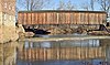
37°22′02″N 89°48′09″W / 37.367222°N 89.8025°W / 37.367222; -89.8025 (Burfordville Covered Bridge)


(#71000463)
37°22′05″N 89°48′06″W / 37.368056°N 89.801667°W / 37.368056; -89.801667 (Burfordville Mill)

(#07000572)
37°27′05″N 89°41′58″W / 37.451389°N 89.699444°W / 37.451389; -89.699444 (Abraham Byrd House)

(#00000820)
37°18′20″N 89°31′06″W / 37.305556°N 89.518333°W / 37.305556; -89.518333 (Cape Girardeau Commercial Historic District)

(#10000856)
37°18′18″N 89°31′12″W / 37.305°N 89.52°W / 37.305; -89.52 (Cape Girardeau Court of Common Pleas)

(#08000663)
37°18′12″N 89°31′50″W / 37.303333°N 89.530556°W / 37.303333; -89.530556 (Central High School)

(#16000084)
37°19′12″N 89°31′57″W / 37.320063°N 89.532561°W / 37.320063; -89.532561 (Dr. Jean Chapman House)

(#94000738)
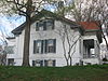
37°18′12″N 89°31′20″W / 37.303333°N 89.522222°W / 37.303333; -89.522222 (George Boardman Clark House)

(#10000723)
37°18′05″N 89°31′17″W / 37.301389°N 89.521389°W / 37.301389; -89.521389 (Courthouse-Seminary Neighborhood Historic District)
(#09000502)
37°18′30″N 89°31′56″W / 37.308333°N 89.532222°W / 37.308333; -89.532222 (Erlbacher Buildings)

(#05001025)
37°18′26″N 89°31′45″W / 37.307222°N 89.529028°W / 37.307222; -89.529028 (Esquire Theater)


(#100004219)
37°17′27″N 89°31′35″W / 37.2909°N 89.5263°W / 37.2909; -89.5263 (Fort D)


(#99000742)
37°22′57″N 89°40′10″W / 37.3825°N 89.669444°W / 37.3825; -89.669444 (Frizel-Welling House)

(#79001354)
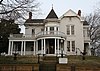
37°17′53″N 89°31′14″W / 37.298056°N 89.520556°W / 37.298056; -89.520556 (Glenn House)
(#07000571)
37°27′04″N 89°27′27″W / 37.451111°N 89.457500°W / 37.451111; -89.457500 (Green’s Ferry)

(#00000819)
37°17′58″N 89°31′38″W / 37.299444°N 89.527222°W / 37.299444; -89.527222 (Haarig Commercial Historic District)


(#87001575)
37°21′10″N 89°33′37″W / 37.352778°N 89.560278°W / 37.352778; -89.560278 (Hanover Lutheran Church)
(#05001375)
37°18′17″N 89°31′17″W / 37.304722°N 89.521500°W / 37.304722; -89.521500 (William Henry and Lilla Luce Harrison House)

(#03000653)
37°18′24″N 89°31′21″W / 37.306667°N 89.522500°W / 37.306667; -89.522500 (Himmelberger and Harrison Building)

(#97000629)
37°18′18″N 89°31′19″W / 37.305000°N 89.521806°W / 37.305000; -89.521806 (House at 323 Themis Street)

(#02000699)
37°17′52″N 89°31′18″W / 37.297778°N 89.521667°W / 37.297778; -89.521667 (Huhn-Harrison House)


(#05001562)
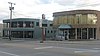
37°22′57″N 89°40′06″W / 37.3825°N 89.668436°W / 37.3825; -89.668436 (Jackson Uptown Commercial Historic District)

(#09000300)
37°17′49″N 89°31′45″W / 37.296944°N 89.529167°W / 37.296944; -89.529167 (Jefferson School)

(#05001090)
37°19′57″N 89°34′45″W / 37.3325°N 89.579167°W / 37.3325; -89.579167 (Kage School)

(#94000739)
37°18′11″N 89°31′11″W / 37.303056°N 89.519722°W / 37.303056; -89.519722 (Klostermann Block)

(#08000535)
37°18′05″N 89°31′18″W / 37.301389°N 89.521667°W / 37.301389; -89.521667 (Edward S. and Mary Annatoile Albert Lilly House)

(#08001259)
37°18′16″N 89°31′08″W / 37.304444°N 89.518889°W / 37.304444; -89.518889 (Main-Spanish Commercial Historic District)

(#02000356)
37°18′24″N 89°31′19″W / 37.306667°N 89.521944°W / 37.306667; -89.521944 (Marquette Hotel)

(#06000042)
37°22′41″N 89°37′07″W / 37.378056°N 89.618611°W / 37.378056; -89.618611 (McKendree Chapel)
(#95001494)
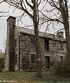
37°25′58″N 89°47′52″W / 37.432778°N 89.797778°W / 37.432778; -89.797778 (Miller-Seabaugh House and Dr. Seabaugh Office Building)

(#09000648)
37°35′52″N 89°42′50″W / 37.597639°N 89.71375°W / 37.597639; -89.71375 (Old Appleton Bridge)

(#05001091)
37°18′40″N 89°31′12″W / 37.311111°N 89.520000°W / 37.311111; -89.520000 (Old Lorimier Cemetery)


(#80002323)
37°18′35″N 89°31′40″W / 37.309722°N 89.527778°W / 37.309722; -89.527778 (Oliver-Leming House)

(#08000226)
37°18′09″N 89°32′19″W / 37.302500°N 89.538611°W / 37.302500; -89.538611 (Abraham Russell Ponder House)

(#99000745)
37°18′22″N 89°31′46″W / 37.306111°N 89.529444°W / 37.306111; -89.529444 (Frederick W. and Mary Karau Pott House)


(#83003942)
37°18′41″N 89°31′05″W / 37.311389°N 89.518056°W / 37.311389; -89.518056 (James Reynolds House)
(#100007826)
37°15′53″N 89°37′34″W / 37.2647°N 89.6260°W / 37.2647; -89.6260 (Shady Grove Cemetery)

(#99000743)
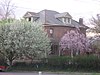
37°17′55″N 89°31′14″W / 37.298750°N 89.520556°W / 37.298750; -89.520556 (August and Amalia Shivelbine House)
(#09000829)
37°18′00″N 89°31′29″W / 37.300000°N 89.524720°W / 37.300000; -89.524720 (South Middle Street Historic District)

(#05000509)
37°18′22″N 89°31′16″W / 37.306111°N 89.521111°W / 37.306111; -89.521111 (Southeast Missourian Building)

(#13001085)
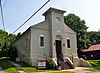
37°18′34″N 89°31′26″W / 37.309543°N 89.523856°W / 37.309543; -89.523856 (St. James A.M.E. Church)

(#82003131)
37°18′03″N 89°31′10″W / 37.300833°N 89.519444°W / 37.300833; -89.519444 (St. Vincent De Paul Catholic Church)

(#05001092)
37°17′47″N 89°31′16″W / 37.296389°N 89.521111°W / 37.296389; -89.521111 (St. Vincent’s College Building)
(#83000974)
37°18′24″N 89°32′30″W / 37.306667°N 89.541667°W / 37.306667; -89.541667 (Col George C. Thilenius House)

(#70000326)

(#09000439)
37°18′23″N 89°31′35″W / 37.306527°N 89.526527°W / 37.306527; -89.526527 (Julius Vasterling Building)

(#04001285)
37°18′20″N 89°31′04″W / 37.305556°N 89.517778°W / 37.305556; -89.517778 (Warehouse Row Historic District)
(#99000987)
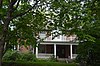
37°17′57″N 89°31′19″W / 37.299305°N 89.522083°W / 37.299305; -89.522083 (Robert Felix and Elma Taylor Wichterich House)
(#15000365)
37°18′34″N 89°31′39″W / 37.309444°N 89.527500°W / 37.309444; -89.527500 (J. Maple and Grace Senne Wilson House)

(#03001269)
37°18′14″N 89°31′33″W / 37.303889°N 89.525833°W / 37.303889; -89.525833 (Wood Building)
Recent Comments