National Register of Historic Places listings in Hancock County, West Virginia
From Wikipedia, the free encyclopedia

Location of Hancock County in West Virginia
This is a list of the National Register of Historic Places listings in Hancock County, West Virginia.
This is intended to be a complete list of the properties and districts on the National Register of Historic Places in Hancock County, West Virginia, United States. The locations of National Register properties and districts for which the latitude and longitude coordinates are included below, may be seen in an online map.[1]
There are 11 properties listed on the National Register in the county.
This National Park Service list is complete through NPS recent listings posted March 31, 2023.[2]
Current listings[edit]
| [3] | Name on the Register | Image | Date listed[4] | Location | City or town | Description |
|---|---|---|---|---|---|---|
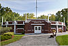
| 1 | Dunbar Recreation Center |
 |
July 22, 2021 (#100006740) |
300 Kessell St. 40°24′45″N 80°35′04″W / 40.4125°N 80.5844°W |
Weirton | |
| 2 | First National Bank-Graham Building |
 |
November 2, 2000 (#00001312) |
100 N. Chester St. 40°29′54″N 80°36′35″W / 40.4983°N 80.6097°W |
New Cumberland | |
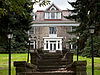
| 3 | Johnston-Truax House |
 |
September 23, 1993 (#93000611) |
209 Seneca St. 40°25′34″N 80°33′27″W / 40.4261°N 80.5575°W |
Weirton | |
| 4 | Marland Heights Park and Margaret Manson Weir Memorial Pool |
 |
November 15, 1993 (#93001230) |
Junction of Williams Dr. and Riverview Dr. 40°24′14″N 80°35′59″W / 40.4039°N 80.5997°W |
Weirton | |
| 5 | Marshall House |
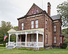 |
March 12, 2001 (#01000263) |
1008 Ridge Ave. 40°29′47″N 80°36′16″W / 40.4964°N 80.6044°W |
New Cumberland | |
| 6 | James F. Murray House |
 |
July 12, 1990 (#90001066) |
530 Louisiana Ave. 40°36′42″N 80°33′42″W / 40.6117°N 80.5617°W |
Chester | Destroyed |
| 7 | People’s Bank |
 |
March 17, 1995 (#95000253) |
3383 Main St. 40°24′05″N 80°35′03″W / 40.4014°N 80.5842°W |
Weirton | |
| 8 | Dr. George Rigas House |
 |
April 21, 2004 (#04000358) |
3412 West St. 40°24′14″N 80°35′26″W / 40.4039°N 80.5906°W |
Weirton | |
| 8 | Peter Tarr Furnace Site |
 |
January 1, 1976 (#76001935) |
Kings Creek Rd., north of Weirton[5] 40°26′15″N 80°34′22″W / 40.4374°N 80.5728°W |
Weirton | |
| 9 | Waterford Park |
 |
December 12, 2002 (#02001528) |
WV 2 40°34′49″N 80°39′42″W / 40.5803°N 80.6617°W |
Newell | |
| 10 | William E. Wells House |
 |
April 23, 2009 (#09000244) |
372 Virginia Terr. 40°36′53″N 80°36′04″W / 40.6147°N 80.6011°W |
Newell | 11 John Village House 3185 Wylie Ridge Road, Weirton, WV. Built in 1774 |
Former listing[edit]
See also[edit]
References[edit]
- ^ The latitude and longitude information provided in this table was derived originally from the National Register Information System, which has been found to be fairly accurate for about 99% of listings. Some locations in this table may have been corrected to current GPS standards.
- ^ National Park Service, United States Department of the Interior, “National Register of Historic Places: Weekly List Actions”, retrieved March 31, 2023.
- ^ a b Numbers represent an alphabetical ordering by significant words. Various colorings, defined here, differentiate National Historic Landmarks and historic districts from other NRHP buildings, structures, sites or objects.
- ^ The eight-digit number below each date is the number assigned to each location in the National Register Information System database, which can be viewed by clicking the number.
- ^ Location derived from this online news story; the NRIS lists the site as “Address Restricted”
Recent Comments