Old Town Hall Historic District (Huntington, New York)
From Wikipedia, the free encyclopedia
Historic district in New York, United States
United States historic place
|
Old Town Hall Historic District |
|
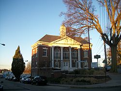
The former Huntington Town Hall as seen from Stewart Avenue and West Main Street, November 13, 2013.
|
|

 |
|

Interactive map showing the location for Huntington Old Town Hall District |
|
| Location | Main St. & Nassau Rd., Huntington, New York |
|---|---|
| Coordinates |
40°52′17″N 73°25′26″W / 40.87139°N 73.42389°WCoordinates: 40°52′17″N 73°25′26″W / 40.87139°N 73.42389°W |
| Area | 5 acres (2.0 ha) |
| Architect | Multiple |
| Architectural style | Late 19th And 20th Century Revivals, Greek Revival, Late Victorian |
| MPS | Huntington Town MRA |
| NRHP reference No. | 85002588[1] |
| Added to NRHP | September 26, 1985 |
Old Town Hall Historic District is a national historic district located at Huntington in Suffolk County, New York. The district has eight contributing buildings. It includes civic buildings, a church, a cemetery, and residential buildings. Properties date from initial settlement in 1653 to the early 20th century. Located in the district are sites such as the Old Huntington Town Hall itself on the northeast corner of Main Street and Stewart Avenue, the Fort Golgotha and the Old Burial Hill Cemetery across from there, and the former Huntington Sewing and Trade School.[2]
It was added to the National Register of Historic Places in 1985.[1]
References[edit]
- ^ a b
“National Register Information System”. National Register of Historic Places. National Park Service. March 13, 2009.
- ^ NYS Parks & Recreation (n.d.). “National Register of Historic Places Registration: Old Town Hall Historic District”. New York State Office of Parks, Recreation and Historic Preservation. Retrieved 2010-02-20. See also: “Accompanying 12 photos”.
External links[edit]
![]() Media related to Old Town Hall Historic District (Huntington, New York) at Wikimedia Commons
Media related to Old Town Hall Historic District (Huntington, New York) at Wikimedia Commons

Recent Comments