Mauregard – Wikipedia
From Wikipedia, the free encyclopedia
Commune in Île-de-France, France
|
Mauregard |
|
|---|---|
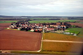 An aerial view of Mauregard |
|
 Coat of arms |
|
|
Location of Mauregard  |
|
 Show map of France  Show map of Île-de-France (region) |
|
| Coordinates:
49°02′00″N 2°34′52″E / 49.0334°N 2.5811°E / 49.0334; 2.5811Coordinates: 49°02′00″N 2°34′52″E / 49.0334°N 2.5811°E / 49.0334; 2.5811 |
|
| Country | France |
| Region | Île-de-France |
| Department | Seine-et-Marne |
| Arrondissement | Meaux |
| Canton | Mitry-Mory |
| Intercommunality | CA Roissy Pays de France |
| Government | |
| • Mayor
(2020–2026) |
Madeleine Latour[1] |
| Area
1 |
8.67 km2 (3.35 sq mi) |
| Population | 361 |
| • Density | 42/km2 (110/sq mi) |
| Time zone | UTC+01:00 (CET) |
| • Summer (DST) | UTC+02:00 (CEST) |
| INSEE/Postal code | |
| Elevation | 98–126 m (322–413 ft) |
| 1 French Land Register data, which excludes lakes, ponds, glaciers > 1 km2 (0.386 sq mi or 247 acres) and river estuaries. | |


Mauregard is a commune in the Seine-et-Marne department in the Île-de-France region in north-central France.
Parts of the Charles de Gaulle International Airport (France’s largest and busiest airport) are located in Mauregard, including Terminal 1 and Terminal 3. The large airport property (over 8,000 acres (3,200 ha)) straddles land in three départements and six communes, with the Roissy-en-France commune providing its alternate name of Roissy Airport.
Demographics[edit]
Inhabitants are called Mauregaulois.
Education[edit]
There is a single preschool and elementary school, Ecole de Mauregard.[3]
See also[edit]
References[edit]
- ^
“Répertoire national des élus: les maires” (in French). data.gouv.fr, Plateforme ouverte des données publiques françaises. 13 September 2022.
- ^ “Populations légales 2019”. The National Institute of Statistics and Economic Studies. 29 December 2021.
- ^ “VIE SCOLAIRE ET PETITE ENFANCE Archived 2016-09-11 at the Wayback Machine.” Mauregard. Retrieved on September 3, 2016.
External links[edit]

Recent Comments