| NÜSSE 1
|
Code
|
NÜSSE 2
|
Code
|
NÜSSE 3
|
Code
|
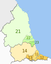
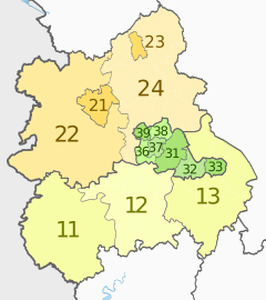
| Nordosten, England
|
UKC
|
Tees Valley und Durham
|
UKC1
|
Hartlepool und Stockton-on-Tees
|
UKC11
|
|
South Teesside (Middlesbrough und Redcar und Cleveland)
|
UKC12
|
| Darlington
|
UKC13
|
| Durham
|
UKC14
|
| Northumberland und Tyne and Wear
|
UKC2
|
Northumberland
|
UKC21
|
| Tyneside (Newcastle upon Tyne, Gateshead, Südtyneside, Nordtyneside)
|
UKC22
|
| Sunderland
|
UKC23
|
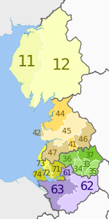
| Nordwesten, England
|
UKD
|
Cumbria
|
UKD1
|
West Cumbria (Allerdale, Barrow-in-Furness, Copeland)
|
UKD11
|
|
East Cumbria (Carlisle, Eden, Süd-Lakeland)
|
UKD12
|
| Cheshire
|
UKD6
|
Warrington
|
UKD61
|
| Cheshire East
|
UKD62
|
| Cheshire West und Chester
|
UKD63
|
| Großraum Manchester
|
UKD3
|
Manchester
|
UKD33
|
| Großraum Manchester Südwesten (Salford und Trafford)
|
UKD34
|
| Greater Manchester South East (Stockport und Tameside)
|
UKD35
|
| Großraum Manchester Nordwesten (Bolton und Wigan)
|
UKD36
|
| Großraum Manchester Nordosten (Bury, Oldham und Rochdale)
|
UKD37
|
| Lancashire
|
UKD4
|
Blackburn mit Darwen
|
UKD41
|
| Blackpool
|
UKD42
|
| Lancaster und Wyre
|
UKD44
|
| Mid Lancashire (Fylde, Preston, Ribble Valley und South Ribble)
|
UKD45
|
| East Lancashire (Burnley, Hyndburn, Pendle und Rossendale)
|
UKD46
|
| Chorley und West Lancashire
|
UKD47
|
| Merseyside
|
UKD7
|
East Merseyside (Knowsley, St. Helens und Halton)
|
UKD71
|
| Liverpool
|
UKD72
|
| Sefton
|
UKD73
|
| Wirral
|
UKD74
|
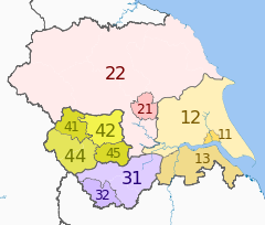
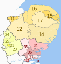
| Yorkshire und der Humber, England
|
UKE
|
East Riding und North Lincolnshire
|
UKE1
|
Kingston upon Hull
|
UKE11
|
|
East Riding of Yorkshire
|
UKE12
|
| Nord- und Nordost-Lincolnshire
|
UKE13
|
| North Yorkshire
|
UKE2
|
York
|
UKE21
|
| North Yorkshire CC
|
UKE22
|
| South Yorkshire
|
UKE3
|
Barnsley, Doncaster und Rotherham
|
UKE31
|
| Sheffield
|
UKE32
|
| West Yorkshire
|
UKE4
|
Bradford
|
UKE41
|
| Leeds
|
UKE42
|
| Calderdale und Kirklees
|
UKE44
|
| Wakefield
|
UKE45
|
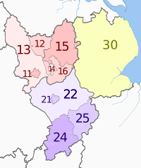
| East Midlands, England
|
UKF
|
Derbyshire und Nottinghamshire
|
UKF1
|
Derby
|
UKF11
|
|
East Derbyshire (Bolsover, Chesterfield, Nordost-Derbyshire)
|
UKF12
|
| Süd- und West-Derbyshire (Amber Valley, Derbyshire Dales, Erewash, High Peak, Süd-Derbyshire)
|
UKF13
|
| Nottingham
|
UKF14
|
| North Nottinghamshire (Ashfield, Bassetlaw, Mansfield, Newark und Sherwood)
|
UKF15
|
| South Nottinghamshire (Broxtowe, Gedling, Rushcliffe)
|
UKF16
|
| Leicestershire, Rutland und Northamptonshire
|
UKF2
|
Leicester
|
UKF21
|
| Leicestershire CC und Rutland
|
UKF22
|
| West Northamptonshire (Northampton, Daventry und South Northamptonshire)
|
UKF24
|
| North Northamptonshire (East Northamptonshire, Corby, Wellingborough und Kettering)
|
UKF25
|
| Lincolnshire
|
UKF3
|
Lincolnshire CC
|
UKF30
|
| West Midlands, England
|
UKG
|
Herefordshire, Worcestershire und Warwickshire
|
UKG1
|
Herefordshire
|
UKG11
|
|
Worcestershire CC
|
UKG12
|
| Warwickshire CC
|
UKG13
|
| Shropshire und Staffordshire
|
UKG2
|
Telford und Wrekin
|
UKG21
|
| Shropshire
|
UKG22
|
| Stoke-on-Trent
|
UKG23
|
| Staffordshire CC
|
UKG24
|
| West Midlands
|
UKG3
|
Birmingham
|
UKG31
|
| Solihull
|
UKG32
|
| Coventry
|
UKG33
|
| Dudley
|
UKG36
|
| Sandwell
|
UKG37
|
| Walsall
|
UKG38
|
| Wolverhampton
|
UKG39
|
| Östlich von England
|
UKH
|
Ostanglien
|
UKH1
|
Peterborough
|
UKH11
|
|
Cambridgeshire CC
|
UKH12
|
| Suffolk
|
UKH14
|
| Norwich und East Norfolk (Broadland und Great Yarmouth)
|
UKH15
|
| Nord- und West-Norfolk
|
UKH16
|
| Breckland und South Norfolk
|
UKH17
|
| Bedfordshire und Hertfordshire
|
UKH2
|
Luton
|
UKH21
|
| Bedford
|
UKH24
|
| Zentrales Bedfordshire
|
UKH25
|
| Hertfordshire
|
UKH23
|
| Essex
|
UKH3
|
Southend-on-Sea
|
UKH31
|
| Thurrock
|
UKH32
|
| Essex Haven Gateway (Braintree, Colchester und Tendring)
|
UKH34
|
| West Essex (Epping Forest, Harlow und Uttlesford)
|
UKH35
|
| Herz von Essex (Brentwood, Chelmsford und Maldon)
|
UKH36
|
| Essex Thames Gateway (Basildon, Castle Point und Rochford)
|
UKH37
|
| London, England
|
UKI
|
Inneres London – Westen
|
UKI3
|
Camden und City of London
|
UKI31
|

|
Westminster
|
UKI32
|
| Hammersmith und Fulham und Kensington und Chelsea
|
UKI33
|
| Wandsworth
|
UKI34
|
| Inneres London – Osten
|
UKI4
|
Hackney und Newham
|
UKI41
|
| Turm Weiler
|
UKI42
|
| Haringey und Islington
|
UKI43
|
| Lewisham und Southwark
|
UKI44
|
| Lambeth
|
UKI45
|
| Äußeres London – Osten und Nordosten
|
UKI5
|
Bexley und Greenwich
|
UKI51
|
| Barking & Dagenham und Havering
|
UKI52
|
| Redbridge und Waltham Forest
|
UKI53
|
| Enfield
|
UKI54
|
| Äußeres London – Süden
|
UKI6
|
Bromley
|
UKI61
|
| Croydon
|
UKI62
|
| Merton, Kingston upon Thames und Sutton
|
UKI63
|
| Äußeres London – West und Nordwesten
|
UKI7
|
Barnet
|
UKI71
|
| Brent
|
UKI72
|
| Ealing
|
UKI73
|
| Harrow und Hillingdon
|
UKI74
|
| Hounslow und Richmond upon Thames
|
UKI75
|
| Südosten, England
|
UKJ
|
Berkshire, Buckinghamshire und Oxfordshire
|
UKJ1
|
Berkshire
|
UKJ11
|

|
Milton Keynes
|
UKJ12
|
| Buckinghamshire CC
|
UKJ13
|
| Oxfordshire
|
UKJ14
|
| Surrey, Ost- und West-Sussex
|
UKJ2
|
Brighton und Hove
|
UKJ21
|
| East Sussex CC
|
UKJ22
|
| West Surrey (Elmbridge, Guildford, Runnymede, Spelthorne, Surrey Heath, Waverley und Woking)
|
UKJ25
|
| East Surrey (Epsom und Ewell, Mole Valley, Reigate und Banstead und Tandridge)
|
UKJ26
|
| West Sussex (Südwesten) – (Adur, Arun, Chichester und Worthing)
|
UKJ27
|
| West Sussex (Nordosten) – (Crawley, Horsham und Mid Sussex)
|
UKJ28
|
| Hampshire und Isle of Wight
|
UKJ3
|
Portsmouth
|
UKJ31
|
| Southampton
|
UKJ32
|
| Isle of Wight
|
UKJ34
|
| South Hampshire (Eastleigh, Fareham, Gosport und Havant)
|
UKJ35
|
| Central Hampshire (East Hampshire, New Forest, Test Valley und Winchester)
|
UKJ36
|
| North Hampshire (Basingstoke und Deane, Hart und Rushmoor)
|
UKJ37
|
| Kent
|
UKJ4
|
Medway
|
UKJ41
|
| Kent Thames Gateway (Dartford, Gravesham und Swale)
|
UKJ43
|
| East Kent (Canterbury, Dover, Folkestone und Hythe und Thanet)
|
UKJ44
|
| Mid Kent (Ashford und Maidstone)
|
UKJ45
|
| West Kent (Sevenoaks, Tonbridge und Malling und Tunbridge Wells)
|
UKJ46
|
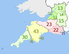
| Südwesten, England
|
UKK
|
Gloucestershire, Wiltshire und Bristol / Bath
|
UKK1
|
Bristol
|
UKK11
|
|
Bath und North East Somerset, North Somerset und South Gloucestershire
|
UKK12
|
| Gloucestershire CC
|
UKK13
|
| Swindon
|
UKK14
|
| Wiltshire
|
UKK15
|
| Dorset und Somerset
|
UKK2
|
Bournemouth und Poole
|
UKK21
|
| Dorset CC
|
UKK22
|
| Somerset
|
UKK23
|
| Cornwall und Scilly-Inseln
|
UKK3
|
Cornwall und Scilly-Inseln
|
UKK30
|
| Devon
|
UKK4
|
Plymouth
|
UKK41
|
| Torbay
|
UKK42
|
| Devon CC
|
UKK43
|
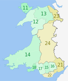
| Wales
|
UKL
|
West Wales und die Täler
|
UKL1
|
Isle of Anglesey
|
UKL11
|
|
Gwynedd
|
UKL12
|
| Conwy und Denbighshire
|
UKL13
|
| Südwestwales (Ceredigion, Carmarthenshire, Pembrokeshire)
|
UKL14
|
| Zentraltäler (Merthyr Tydfil, Rhondda Cynon Taff)
|
UKL15
|
| Gwent-Täler (Blaenau Gwent, Caerphilly, Torfaen)
|
UKL16
|
| Bridgend und Neath Port Talbot
|
UKL17
|
| Swansea
|
UKL18
|
| Ostwales
|
UKL2
|
Monmouthshire und Newport
|
UKL21
|
| Cardiff und Vale of Glamorgan
|
UKL22
|
| Flintshire und Wrexham
|
UKL23
|
| Powys
|
UKL24
|
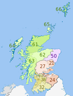
| Schottland
|
UKM
|
Ostschottland
|
UKM2
|
Angus und Dundee
|
UKM21
|

|
Clackmannanshire und Fife
|
UKM22
|
| East Lothian und Midlothian
|
UKM23
|
| Schottische Grenzen
|
UKM24
|
| Edinburgh
|
UKM25
|
| Falkirk
|
UKM26
|
| Perth und Kinross und Stirling
|
UKM27
|
| West Lothian
|
UKM28
|
| Südwestschottland
|
UKM3
|
East Dunbartonshire, West Dunbartonshire und Helensburgh und Lomond
|
UKM31
|
| Dumfries und Galloway
|
UKM32
|
| Ost- und Nord-Ayrshire-Festland
|
UKM33
|
| Glasgow
|
UKM34
|
| Inverclyde, East Renfrewshire und Renfrewshire
|
UKM35
|
| North Lanarkshire
|
UKM36
|
| Süd-Ayrshire
|
UKM37
|
| South Lanarkshire
|
UKM38
|
| Nordostschottland
|
UKM5
|
Aberdeen und Aberdeenshire
|
UKM50
|
| Hochland und Inseln
|
UKM6
|
Caithness und Sutherland sowie Ross und Cromarty
|
UKM61
|
| Inverness, Nairn, Moray und Badenoch und Strathspey
|
UKM62
|
| Lochaber, Skye und Lochalsh, Arran und Cumbrae sowie Argyll und Bute (außer Helensburgh und Lomond)
|
UKM63
|
| Eilean Siar (Westinseln)
|
UKM64
|
| Orkney-Inseln
|
UKM65
|
| Shetlandinseln
|
UKM66
|
| Nordirland
|
UKN
|
Nordirland
|
UKN0
|
Belfast
|
UKN01
|

|
Äußeres Belfast (Carrickfergus, Castlereagh, Lisburn, Newtownabbey, North Down)
|
UKN02
|
| Östlich von Nordirland (Antrim, Ards, Ballymena, Banbridge, Craigavon, Down, Larne)
|
UKN03
|
| Nordnordirland (Ballymoney, Coleraine, Derry, Limavady, Moyle, Strabane)
|
UKN04
|
| West und Süd von Nordirland (Armagh, Cookstown, Dungannon, Fermanagh, Magherafelt, Newry und Mourne, Omagh)
|
UKN05
|
| NUTS Extra-regio 1
|
UKZ
|
NUTS außerhalb des Regios 2
|
UKZZ
|
NUTS Extra-regio 3
|
UKZZZ
|
Recent Comments